Migori County

Last updated

Migori
Migori County
Awendo Migori Kenia.jpg
Close to Awendo Town, Migori
Migori County in Kenya.svg
Location in Kenya
CountryFlag of Kenya.svg  Kenya
Formed4 March 2013
Capital Migori
Government
   Governor Ochilo Ayacko
Area
  Total2,586.4 km2 (998.6 sq mi)
Population
 (2019)
  Total1,116,436
  Density430/km2 (1,100/sq mi)
Time zone UTC+3 (EAT)
Website migori.go.ke

Migori County is a county in the former Nyanza Province of southwestern Kenya. It borders Homa Bay County to the north, Kisii County to the northeast, Narok County to the southeast, Tanzania to the west and south, and Lake Victoria to the west. The county also borders Uganda via Migingo Island in Lake Victoria. The county is headquartered by Migori, which is also its largest town. At the 2019 census, Migori County had a population of 1,116,436, almost 200,000 more than the 917,170 recorded in 2009. [1]

Contents

Migori County is located in the sugar belt wetlands of western Kenya and is mostly at the heart of the African tropics. However, the county enjoys a pleasant climate due to its high altitude which modifies the climate alongside the cool breeze from Lake Victoria.

Demographically, Migori County is the most diverse region of the former Nyanza Province after Kisumu County. Its inhabitants include the Suba, Joluo, Kuria, Abagusii, Luhya, Somalis, Indians, Arabs, Agikuyu and Nubians.

The county is important to Kenya because of the significance of Isebania border post to the East African economy, the A-1 Kenya-Tanzania cuts the county in half, the place of Sony (South Nyanza) Sugar Company in the lives of over one hundred thousand households in Kenya, the influential role of Lake Victoria on food sustainability of Western region of Kenya, and its sizeable meat industry courtesy of the ranches in Kurialand and Suna West.

Migori town serves as in important link between Kenya and Tanzania and the second most viable commercial center in Luo-Nyanza after Kisumu. Other major towns in Migori county include Kehancha, Rongo, Awendo and Isebania in Kuria District.

Religion

Religion in Migori County [2]

Religion (2019 Census)Number
Catholicismy 190,734
Protestant 411,800
Evangelical Churches 280,400
African instituted Churches 152,709
Orthodox 8,012
Other Cristian 32,242
Islam 7,552
Hindu 134
Traditionists2,652
Other14,495
No ReligionAtheists 7,370
Don't Know712
Not Stated137

Location

Migori Town (-1.0634,34.4731) is 368 kilometers from Nairobi. Migori town is bordered by hills.

Muhuru Bay in Migori.jpg

Water bodies in the county include the Kuja and Migori rivers, and Lake Victoria.

Economy

The main economic activities include agriculture, fishing, manufacturing and mining. There is some small scale gold mining carried out in the county.

The county also sees some limited commercial activity, mainly small and micro-enterprises in the Jua Kali sector. These include auto mechanics, furniture works, tailoring, welding, trade and agriculture.

Agricultural activity is carried out in areas such as Ngege, Oyani and Anjego. There is a national cereals board depot in Migori Town.

Demographics

According to the Kenya National Bureau of Statistics National Census data Migori has a population of 1,116,436 with 536,187 males and 580,214 females, and 35 intersex. Below is the breakdown of the population based on the constituencies of the county.

  1. Kuria West 101,090 (Male) 107,417 (Female) 6 (Intersex) Total= 208,513      
  2. Nyatike 83,989 (Male) 92,164 (Female) 9 (Intersex) Total= 176,162    
  3. Uriri 68,127 (Male)  73,318 (Female) 3 (Intersex) Total= 141,448
  4. Suna West 61,430 (Male) 67,459 (Female) 1 (Intersex) Total= 128,890  
  5. Rongo 59,257 (Male) 65,329 (Female) 1 (Intersex) Total= 124,587
  6. Suna East 58,977 (Male)  63,694 (Female) 3 (Intersex) Total= 122,674
  7. Awendo 56,348 (Male)  60,939 (Female) (Intersex)        Total= 117,290
  8. Kuria East 46,969 (Male) 49,894 (Female) 9 (Intersex) Total= 96,872 [3]

The population density is 353 PER SQ. km and 43% of the population live below the poverty line. The age distribution was 0–14 years 49%, 15–64 years 48% and over 65 years 3%. Kuria West Constituency has the highest density at 490/km2 while Nyatike Constituency had the lowest at 213/km2. While the population of the county as of 2009 was 917,170, it is expected to grow to about 1.3 million people by 2018. Children below the age of 15 account for 49% of the population of the county. [4]

Urban Centers and Towns

Thimlich Ohinga Cultural Landscape- Kenya.JPG

Migori County has several urban centers and municipalities which are clustered into two groups. The first are towns councils and municipalities and include Migori town in Suna East/and Suna West which has about 100,000 people. Migori town acts as the capital of the county and hosts several important economic and political institutions. The second municipality is Kehancha town in Kuria West which has a population of approximately 50,000 people.

The second cluster of urban centers in Migori are town councils and these include Rongo Town, Awendo Town and Isebania border.

Other important trading centers or rural shopping centers in the county include Muhuru Bay, Macalder Mines, Karungu Bay, Bondo Nyironge, Ogwedhi Sigawa, God Jope, Giribe among others.

Climate

Migori county has two main rainy seasons. The first rainy seasons starts in March and ends in May and is called long rains. The second season called "opon" starts in September and ends in November. The driest months are between December and February and June and September. The minimum average temperatures is usually the low of 24 degrees Celsius (74 F) and a high of 31 degrees Celsius (87 F). Rainfalls come in the afternoon and the heat is often dry and thus bearable.

Tourism and Places to Visit

The county has no official national park or game reserve. However, the county boasts of several interesting places of interest that one can find appealing to visit.

Macalder Mines

People working.jpg

This is a 90 km gold belt that has been exploited for over 70 years by artisan miners using traditional method.

Gogo Falls

The dam which was built on River Kuja in 1957 provides a capacity of about 60 watts and is a primary source of power for the towns in the county and water for the dams.
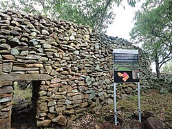
Thimlich Ohinga

This is an old African civilization of the Luo people of Kadem clan formerly labeled Liare Valley and described as "the frightening dense forest." This old settlement was a village built on stones by the early Luo/Suba people around the 14th century. Ohinga is a Luo word for fort wall.

God Kweru Shrine

Locally known as the "Calvary" this place is a religious site for the Legio Maria followers, a traditional African religion formed to fight colonialism in the 1940s. The followers of Legio Maria host their yearly pilgrimages at the Got Kweru shrine in Suna West. [5]

Muhuru Bay

Lake Victoria's Mugabo beach beauty 01.jpg

Muhuru Bay is the Miami of Migori County. It provides white sandy shores lined with palms comes and magnificent natural sites and bays. It is also known for fresh Lake Victoria Nile Perches, Tilapia, Kamongo among other fishes. There is a beach hotel named Muhuru Bay Beach Hotel where events such as boat excursion, exploring, fishing and bird watching happens. Muhuru Bay is increasingly popular with back packers from the United States.

Kogaja Village

Cross the border at a rural post in Kopanga and enjoy the serenity of the rural folks at Suna West as they plant cassava in the fields and cross the border between Kenya and Tanzania as if the border doesn't exist. [6]

Flora and fauna

Some common trees and shrubs include Bondo ( Euphorbia candelabrum ), Ochwoga ( Carissa edulis ), Mukinduri ( Croton megalocarpus ), Ngow (fig), Bong'u ( Ficus spp.), Onera ( Terminalia brownii ), Toona ciliata , Ochond rateng'/Musaja ( Sapium spp.), Oncoba spinosa , Terminalia catappa , and cypress.

The birds here are varied with many records of blue flycatcher, blue-spotted wood dove, harrier hawk, bat hawk, baglafecht weaver, tawny eagle, purple grenadier, sunbird, yellow-billed stork, hadada ibis, African citril, cape turtle dove, paradise flycatcher, yellow white eye, white-browed robinchat, black-headed gonolek, and black kite among others.

Education

Only 15% of Migori County residents have secondary level of education or above. Rongo constituency has the highest share of residents with a secondary level of education or above at 19%. This is 7 percentage points above Kuria East constituency, which has the lowest share. [7]

Rongo constituency is 4 percentage points above the county average. Suna Central ward has the highest share of residents with a secondary level of education or above at 31%. This is five times Wasimbete ward, which has the lowest share of residents with a secondary level of education or above. Suna Central ward is 16 percentage points above the county average. [8]

A total of 65% of Migori County residents have a primary level of education only. Uriri constituency has the highest share of residents with a primary level of education only at 68%. [9] This is 5 percentage points above Kuria West constituency, which has the lowest share of residents with a primary level of education only. Uriri constituency is 3 percentage points above the county average. West Kanyamkago ward has the highest share of residents with a primary level of education only at 71%. This is 19 percentage points above Isibania ward, which has the lowest share of residents with primary only. West Kanyamkago ward is 6 percentage points above the county average. [10]

Some 20% of Migori County residents have no formal education. Kuria East constituency has the highest share of residents with no formal education at 24%. [11] This is 6 percentage points above Rongo constituency, which has the lowest share of residents with no formal education. Kuria East constituency is 4 percentage points above the county average. Ntimaru East ward has the highest percentage of residents with no formal education at 31%. This is twice Central Kamagambo ward, which has the lowest percentage of residents with no formal education. Ntimaru ward is 11 percentage points above the county average.

Employment

In Migori County, 9% of the residents with no formal education, 9% of those with a primary education and 22% of those with a secondary level of education or above are working for pay.

Roads

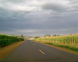
The main highway in Migori is the A-1 road to Tanzania which passes from Rongo to Isebania and is the only road on bitumen standard at around 105 kilometers. The rest of the roads are 1928 kilometers of which a quarter are gravel while majority are earth roads.

Airports

The county is served with three airstrips namely Lichota ( Migori Town), Macalder Mines and Kehancha. .

Energy

Only 1% of residents in Migori County use liquefied petroleum gas (LPG), and 2% use paraffin. 80% use firewood and 17% use charcoal. Firewood is the most common cooking fuel by gender with 85% of female headed households and 77% of male headed households using it.

Uriri constituency has the highest level of firewood use in Migori County at 93%.This is 23 percentage points above Suna West constituency, which has the lowest share at 70%. Uriri constituency is about percentage points above the county average. West Kanyamkago ward has the highest level of firewood use in Migori County at 98%.This is five times Isibania ward, which has the lowest share. West Kanyamkago ward is 18 percentage points above the county average.

Suna West constituency has the highest level of charcoal use in Migori County at 26%.This is 20 percentage points above Uriri constituency, which has the lowest share. Suna West constituency is 9 percentage points above the county average. Isibania ward has the highest level of charcoal use in Migori County at 71%.This is 69 percentage points more than Kaler ward, which has the lowest share. Isibania ward is 54 percentage points above the county average. Only 5% of residents in Migori County use electricity as their main source of lighting. A further 26% use lanterns, and 66% use tin lamps. 1% use fuel wood. Electricity use is mostly common in male headed households at 6% as compared with female headed households at 4%.

Awendo constituency has the highest level of electricity use at 11%.That is 11 percentage points above Kuria East constituency, which has the lowest level of electricity use. Awendo constituency is 6 percentage points above the county average. Isibania ward has the highest level of electricity use at 26%.That is 26 percentage points above Ntimaru East ward, which has no level of electricity use. Isibania ward is 21 percentage points above the county average

Health

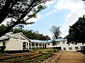
Migori County has four district hospitals and five sub-district hospitals, namely Awendo, Rongo, Uriri.

The most prevalent diseases in the county are malaria, HIV/AIDS, diarrhea, and upper respiratory tract infections.

Religion

The vast majority of Migori Kenyans are Christians, with the Seventh-day Adventist, Anglican and Roman Catholic churches being the most established Christian denominations. Other well-established denominations include the African Inland Church and the Presbyterian Church of East Africa.

In addition, there are a number of Evangelical churches and Independent African Christian churches.

Islam is another major religion in Migori. Followers include both Sunni and Shi'ite Muslims. The largest number of Muslims in Migori are found in Migori town centre and the neighboring regions.

Many of the traditional African religions are no longer widely practiced. Some of the denominations considered as indigenous religions combine aspects of Christianity with traditional religious beliefs. Two of these denominations are Legio Maria and Roho Israel, found mostly in rural areas.

The few Migorians who adhere to Hinduism and Sikhism are mostly Indians. They reside mostly in Migori Town.

Subdivisions

Local authorities (councils)
AuthorityTypePopulation*Urban pop.*
Migori Municipality46,57631,644
Awendo Town93,38713,760
Rongo Town64,5286,175
Migori CountyCounty310,4064,331
Total-514,89755,910
* 1999 census. Source:
Administrative divisions
DivisionPopulation*Urban
population*
Population
density
Headquarters
Awendo90,15313,509352Awendo
Karungu27,9013,322201Karungu
Muhuru16,8820386
Nyatike65,5020133
Rongo79,8172,918376Rongo
Suba East91,54829,825451Migori
Suba West52,8760191
Uriri90,2180237Uriri
Total514,89749,574257 (average)-
* 1999 census. Sources: ,

The county has eight constituencies: [12]

Villages and settlements

See also

Related Research Articles

<span class="mw-page-title-main">Suba people (Kenya)</span> Bantu group of people in Kenya

The Suba (Abasuba) are a heterogeneous Bantu group of people in Kenya with an amalgamation of clans drawn from their main tribes Ganda people, Luhya people, and Soga who speak the Suba language that is closely similar to the Ganda language spare some lexical items borrowed from [[Luo. Their population is estimated at 157,787, with substantial fluent speakers. They migrated to Kenya from Uganda and settled on the two Lake Victoria islands of Rusinga and Mfangano, others also settled on the mainland areas including Gembe, Gwassi, Kaksingri of Suba South and Migori and are believed to be the last tribe to have settled in Kenya. The immigrants to present-day Subaland trace their ancestry among Ganda people, Luhya people, Soga people, and the Luo people. The evidence supporting this is the fact that some Suba groups speak languages similar to Luganda, Lusoga and the Luhya. The Suba groups tracing ancestry among the Kenyan tribes preceded those groups from Uganda in present-day Subaland and are the numerous and influential ones. Those groups from Uganda are mostly concentrated in Rusinga and Mfangano islands with small pockets of them being found in mainland Kenya. Linguistically, the Suba are highly influenced by the neighbouring Luo, to the point of a language shift having taken place among large portions of the mainland Suba. As a result, their own language has been classified as endangered. Despite this language shift, the Suba have kept a distinct ethnic identity. The Rusinga Festival is held in December of every year as a cultural festival to celebrate and preserve Suba culture and language.

<span class="mw-page-title-main">Kakamega County</span> County in Kenya

Kakamega County is a county in the former Western Province of Kenya. It borders Vihiga County to the South, Siaya County to the West, Bungoma and Trans Nzoia counties to the North and Nandi and Uasin Gishu counties to the East. Its capital and largest town is Kakamega. The county has a population of 1,867,579 and an area of 3,033.8 km2.

<span class="mw-page-title-main">Narok County</span> County in Kenya

Narok County is a county in southwestern Kenya with an estimated population of 1,157,873 according to 2019 Census. The dominant ethnic group is the Maasai. Its capital and largest town is Narok, with the only other major urban centre being Kilgoris. Narok County Government was formed by the County Governments Act of 2012 as prescribed in the 2010 Constitution of Kenya. Narok County governor is Patrick Ole Ntutu after winning in the 2022 elections and his Deputy is Tamalinye K. Koech.

<span class="mw-page-title-main">Marsabit County</span> County in Kenya

Marsabit County is a county in Kenya. Covering a surface area of 66,923.1 square kilometres. Marsabit is the second largest county by size in Kenya after Turkana county which has an area of 71,597.8 km2. Its capital is Marsabit and its largest town is Moyale. According to the 2019 census, the county has a population of 459,785. It is bordered to the North by Ethiopia, to the West by Turkana County to the South by Samburu County and Isiolo County, and to the East by Wajir County.

<span class="mw-page-title-main">Local authorities of Kenya</span> Bodies controlling local governance in urban areas in Kenya

Local authorities in Kenya are the bodies controlling local governance in urban areas in Kenya.

<span class="mw-page-title-main">Migori</span>

Migori county 044, also known as Suna-Migori, is a multi-ethnic municipal town which acts as the capital of Migori County, Kenya. The town is located 63 kilometers south of Kisii town and 22 km north of the Tanzanian border. The Migori Metropolitan area consists of Migori municipality and the adjacent smaller towns. The area has eight constituencies, namely Rongo, Awendo, Suna East, Suna West, Uriri, Nyatike, Kuria East and Kuria West with a total population of 393,012 according to the Kenya National Bureau of Statistics-sponsored national census of 2019. The neighboring town/constituency of Awendo has 96,872 and Kuria East (Sirare) has 117, 290. In 2010, The Star newspaper reported that the town (proper) had a population of approximately 100,000 people.

<span class="mw-page-title-main">Homa Bay County</span> County in Kenya

Homa Bay County is a county in the former Nyanza Province of Kenya. Its capital and largest town is Homa Bay. The county has a population of 1,131,950 and an area of 3,154.7 km2. Lake Victoria is a major source of livelihood for Homa Bay County. It has 40 wards, each represented by an MCA in the Homa Bay county assembly located in Homa Bay town, which is the county headquarters.

Kuria District was an administrative district in the Nyanza Province of Kenya. Its capital town is Kehancha. The district has a population of 256,086 and an area of 581/km2. It is inhabited by a minority group of people fondly known as Kuria people, also referred to as Abakuria (Mkuria/Wakuria) in Swahili. They are scattered across the Kenya-Tanzania border and are neighbors to the Kisii, Luo, and Maasai people.

<span class="mw-page-title-main">Garissa County</span> County in Kenya

Garissa County is an administrative county in Kenya. It is located in Eastern Kenya bordering Somalia to the East, Wajir County and Isiolo County to the North, Tana River County to the West and Lamu County to the South. Its capital and largest urban area is Garissa.

<span class="mw-page-title-main">Demographics of Birmingham</span>

The demography of Birmingham, England, is analysed by the Office for National Statistics and data produced for each of the wards that make up the city, and the overall city itself, which is the largest city proper in England as well as the core of the third most populous urban area, the West Midlands conurbation.

Migori was an electoral constituency in Kenya. It is one of eight constituencies of Migori County. The constituency was established for the 1963 elections. In 2013, the constituency was divided into Suna West and Suna East.

Nyatike is an electoral constituency in Kenya. It is one of eight constituencies of Migori County. There are seven wards in the constituency, all electing members (MCAs) to the Migori County Assembly. The constituency was established for the 1988 elections. Being a semi-arid region, residents of Nyatike mainly depend on fishing as the major economic activity. Around the areas of Macalder and Osiri, small-scale gold mining has also become a source of livelihood. Currently, the constituency is a major player in Migori County politics as it has the highest number of voters of the 8 constituencies.

<span class="mw-page-title-main">Nairobi City County</span> County of Kenya

Nairobi City County is one of the 47 counties of Kenya. With an estimated population of 5,454,000 in 2024, it is the third smallest yet the most populous of the counties, also serving as the capital of Kenya. In 2013, the county entity was effected, replacing Nairobi City Council, the long-standing unit of administration since pre-independence. The city county consists of eleven gazetted sub-counties and eighty five electoral wards. On the national level, Nairobi also sends seventeen Members of Parliament across the constituencies and one County Woman Representative to the National Assembly; one senator to the Senate. The county government, which is allocated devolved functions as per the constitution, is headed by the county governor, who appoints his cabinet. The county's legislature is headed by the County Speaker, who presides over the County Assembly: single-member elected Members of the County Assembly (MCAs) represent their respective electoral wards. Additional MCAs are also nominated by political parties as a form of affirmative action.

<span class="mw-page-title-main">Sub-Counties of Kenya</span>

Sub-counties, also known as Districts, are the decentralised units through which government of Kenya provides functions and services. At national level, sub-counties take a more administrative function like security, statistical purposes, provision of government services, etc. Even though the sub-counties are divisions of counties, powers to create new national sub-counties lies with the national government. As of 2023, there are 314 sub-counties, compared to 290 constituencies. A deputy county commissioner is appointed by the state to lead each sub-county. The sub-counties are further divided into divisions, locations and sub-locations.

Migori District was an administrative district in the Nyanza Province of Kenya. It is located in southwestern Kenya. Its capital town was Migori. The district has a population of 514,897 and an area of 2,005 km2.

The Isebania–Kisii–Ahero Road is a road section of the A1 road in Kenya, connecting the towns of Isebania, Migori, Kisii and Ahero.

Suna East is a constituency in Kenya. It is one of eight constituencies in Migori County. It was established in 2013 when Migori Constituency was divided into Suna West and Suna East.

Suna West is a constituency in Kenya. It is one of eight constituencies in Migori County. It was established in 2013 when Migori Constituency was divided into Suna East and Suna West.

<span class="mw-page-title-main">John Owino</span> Kenyan politician

Hon. John Walter Owino, is a Kenyan politician and member of the National Assembly for Awendo Constituency. He is a member of the Orange Democratic Movement.

References

  1. "Kenya's population census results at a glance".
  2. "2019 Kenya Population and Housing Census Volume IV: Distribution of Population by Socio-Economic Characteristics" (PDF). Kenya National Bureau of Statistics. Retrieved 2 May 2021.
  3. "CENSUS: Kuria West most populous constituency, pass Nyatike which record a decline | Migori News". migorinews.co.ke. Retrieved 5 November 2019.
  4. "Info". findingkenya.com. Retrieved 19 September 2018.
  5. "God Kweru Shrine | Attractions in Migori". Twenzetu. Retrieved 28 May 2020.
  6. "Kogaja Village | Atrractions in Migori". Twenzetu. Retrieved 28 May 2020.
  7. "Transforming Community through Education". drpamelaofoundation.org. Retrieved 28 May 2020.
  8. "Transforming Community through Education". drpamelaofoundation.org. Retrieved 28 May 2020.
  9. "Transforming Community through Education". drpamelaofoundation.org. Retrieved 28 May 2020.
  10. "Transforming Community through Education". drpamelaofoundation.org. Retrieved 28 May 2020.
  11. "Transforming Community through Education". drpamelaofoundation.org. Retrieved 28 May 2020.
  12. "Constituency – Constituencies in Kenya". softkenya. Retrieved 9 June 2018.

0°40′S34°50′E / 0.667°S 34.833°E / -0.667; 34.833