Humboldt, Kansas

Last updated

Humboldt, Kansas
City Square Park Bandstand NRHP 13001036 Allen County, KS.jpg
City Square Park Bandstand and City Water Tower (2021)
Allen County Kansas Incorporated and Unincorporated areas Humboldt Highlighted.svg
Location within Allen County and Kansas
Map of Allen Co, Ks, USA.png
Coordinates: 37°48′45″N95°26′11″W / 37.81250°N 95.43639°W / 37.81250; -95.43639 [1]
Country United States
State Kansas
County Allen
Founded1857
Incorporated 1878
Named for Baron von Humboldt
Area
[2]
  Total1.50 sq mi (3.89 km2)
  Land1.49 sq mi (3.87 km2)
  Water0.01 sq mi (0.02 km2)  0.69%
Elevation
[1]
974 ft (297 m)
Population
 (2020) [3]
  Total1,847
  Density1,200/sq mi (470/km2)
Time zone UTC-6 (CST)
  Summer (DST) UTC-5 (CDT)
ZIP code
66748
Area code 620
FIPS code 20-33450
GNIS ID 485596 [1]
Website{URL

Humboldt is a city in Allen County, Kansas, United States. [1] It is situated along the Neosho River. As of the 2020 census, the population of the city was 1,847. [3]

Contents

History

Humboldt, c. 1865-1875 Humboldt, Kansas (circa 1865-1875).jpg
Humboldt, c.1865–1875

19th century

Humboldt, originally a American settlement named after Baron von Humboldt, was founded in 1857. [4] Germans migrating from Hartford, Connecticut, began organizing a colony during the winter of 1856–57. They arrived in Lawrence, Kansas, in March 1857, and at the townsite on May 10, 1857. Orlin Thurston, a young attorney, moved to Humboldt during the summer of 1857 and put up a steam sawmill; he began sawing wood and building houses on the prairie side of town. The first frame building was erected by J.A. Coffey; and in May 1858, W.C. O'Brien opened the first gristmill in the county. The United Brethren Denomination erected the first church in 1859. [5]

In 1861 Humboldt was attacked by a collection of border ruffians and Osages led by John Mathews out of Oswego, Kansas who took several recently freed African-Americans back into captivity. The Humboldt Home Guard joined with the Kansas 6th Cavalry under James G. Blunt to counter-attack. In a battle on September. 18, 1861 Mathews was killed at Chetopa, Kansas.

The city was organized as a village in 1866 and incorporated as a city of the second class by the act of February 28, 1870. In October 1870 the Leavenworth, Lawrence & Galveston railway was run through Humboldt; [6] the railway was operated during the 20th century as part of the Atchison, Topeka and Santa Fe Railway and is currently operated by the South Kansas and Oklahoma Railroad.

Humboldt was the Allen county seat for seven years, from 1858 until 1865, when Iola became the seat. Humboldt won two contentious legislative elections to become the seat in 1858 and 1860, but another election in 1865 at the end of the American Civil War resulted in the re-location of the county seat to Iola. The legitimacy of this election was questioned by Humboldt residents due to low turnout arising from soldiers fighting the War. Some residents claim that the county seat was "stolen". Iola effectively secured the seat by donating 100 lots to the county to aid in the construction of public buildings and subsequently raising funds to build a courthouse.[ citation needed ] However, Humboldt was also guilty of shady practices. Lieut. Col. Charles W. Blair, the commander of Fort Scott, temporarily replaced the commander of the post at Humboldt, Maj. Henry C. Haas, to keep the soldiers there from illegally voting in the county seat election. Blair claimed none of the troops were legal voters in Humboldt. The Humboldt newspaper, however, denied the troops had been involved in any wrongdoing. County seat wars of this sort were common in Kansas and the American West. [7] [8]

Civil War fortifications

Humboldt was very much involved in the American Civil War. The town was raided September 1, 1861, by Confederate raiders, who took much property and kidnapped eight free blacks, who may have been placed into slavery. Several persons may have been wounded by gunfire, but no one was killed. Many of the raiders were hunted down and one of the leaders, Col. John Mathews, was killed. [9]

Actions were taken to prevent Humboldt coming under further attack. Two home guard companies were organized in the Humboldt area. These militia units sought to protect the town and to scout as far south as the Kansas-Indian Territory border to prevent Confederates from coming too close to town. Some of the militia were involved with the pursuit of the September raiders. Two Humboldt area structures, O'Brien's Mill and W. W. Curdy dry goods store, were fortified. [10] [11] [12]

Amazingly, Humboldt fell victim to another raid on October 14, 1861, 1+12 months after the first raid. The second raid caught the town totally off guard and the 100 home guards surrendered when they discovered they could not protect the town from the 330 raiders. O'Brien's Mill and most of the town was burned. The W. W. Curdy store apparently was spared, but it played no further role in Humboldt's defenses. It was said the second raid was at least in part revenge for the killing of Mathews and for the actions of U.S. Senator James H. Lane and his brigade's sacking and destruction of Osceola, Missouri. [13] [14]

After the second raid the threats to Humboldt's safety were taken very seriously. At times the town had local militia units operating and most of the rest of the Civil War the town had Army troops stationed there. Sometimes the military post there was called Post Humboldt. A blockhouse was partially constructed at 514 S. 3rd Street. This was used by the local militia as its headquarters and as a recruiting office. [15] [16]

Other points in town were used by the military. The German settlers in town built a church on Bridge Street, in the east part of town. This was used as the post's quartermaster store and was run by a sergeant. On the west side of town, a number of cabins were built on the east side of the Neosho River. This was sometimes called Log Town, but was more commonly known as Camp Hunter. When the ranks swelled beyond the capacity of the cabins, tents were pitched at the camp. Of the places used by the military, home guards and militia, today only the German church stands and it was converted into a private residence in the 1950s. The geographic coordinates of the various points are:

In October 1864, the area was threatened by a huge raid through Missouri and eastern Kansas. The Confederate raiders were commanded by Maj. Gen. Sterling Price and most of the troops and militia went to meet the threat further east. Also, in the same time period Maj. Haas, in command of the troops, and Maj. Watson Stewart, in command of the militia had differences of opinion as to the extent of the jurisdiction of Haas. Haas wanted control of the militia and Stewart contested this. The militia maintained its independence, but not until Haas managed to arrest one of the militia's officers. [17] [18]

The post at Humboldt was manned by troops at least through June 1865. It probably lasted into July and very possibly into August. When troops abandoned the town, the use of the military buildings came to an end, as well. [19] [20]

Geography

According to the United States Census Bureau, the city has a total area of 1.45 square miles (3.76 km2), of which 1.44 square miles (3.73 km2) is land and 0.01 square miles (0.03 km2) is water. [21]

Humboldt is situated along the east bank of the Neosho River, midway between Iola (to the north) and Chanute (to the south, in Neosho County) along Old 169 Highway.

Climate

The climate in this area is characterized by hot, humid summers and generally mild to cool winters. According to the Köppen climate classification system, Humboldt has a humid subtropical climate, abbreviated "Cfa" on climate maps. [22]

Demographics

Historical population
CensusPop.Note
1870 1,202
1880 1,54228.3%
1890 1,361−11.7%
1900 1,4023.0%
1910 2,54881.7%
1920 2,525−0.9%
1930 2,5581.3%
1940 2,290−10.5%
1950 2,3080.8%
1960 2,285−1.0%
1970 2,249−1.6%
1980 2,230−0.8%
1990 2,178−2.3%
2000 1,999−8.2%
2010 1,953−2.3%
2020 1,847−5.4%
U.S. Decennial Census

2010 census

As of the census [23] of 2010, there were 1,953 people, 829 households, and 511 families residing in the city. The population density was 1,356.3 inhabitants per square mile (523.7/km2). There were 923 housing units at an average density of 641.0 per square mile (247.5/km2). The racial makeup of the city was 94.0% White, 1.4% African American, 0.6% Native American, 0.1% Pacific Islander, 2.0% from other races, and 2.0% from two or more races. Hispanic or Latino of any race were 5.1% of the population.

There were 829 households, of which 30.6% had children under the age of 18 living with them, 46.2% were married couples living together, 10.0% had a female householder with no husband present, 5.4% had a male householder with no wife present, and 38.4% were non-families. 34.0% of all households were made up of individuals, and 17.6% had someone living alone who was 65 years of age or older. The average household size was 2.33 and the average family size was 2.97.

The median age in the city was 40.7 years. 25.2% of residents were under the age of 18; 6.9% were between the ages of 18 and 24; 23.6% were from 25 to 44; 26.5% were from 45 to 64; and 18% were 65 years of age or older. The gender makeup of the city was 46.8% male and 53.2% female.

2000 census

As of the U.S. Census in 2000, [24] there were 1,999 people, 825 households, and 554 families residing in the city. The population density was 1,403.3 inhabitants per square mile (541.8/km2). There were 925 housing units at an average density of 649.4 per square mile (250.7/km2). The racial makeup of the city was 93.00% White, 1.75% Black or African American, 0.45% Native American, 0.10% Asian, 2.65% from other races, and 2.05% from two or more races. Hispanic or Latino of any race were 5.15% of the population.

There were 825 households, out of which 27.5% had children under the age of 18 living with them, 54.4% were married couples living together, 8.7% had a female householder with no husband present, and 32.8% were non-families. 29.1% of all households were made up of individuals, and 14.7% had someone living alone who was 65 years of age or older. The average household size was 2.37 and the average family size was 2.92.

In the city, the age distribution of the population shows 23.6% under the age of 18, 8.9% from 18 to 24, 24.2% from 25 to 44, 22.9% from 45 to 64, and 20.4% who were 65 years of age or older. The median age was 40 years. For every 100 females, there were 96.8 males. For every 100 females age 18 and over, there were 91.8 males.

The median income for a household in the city was $30,408, and the median income for a family was $39,750. Males had a median income of $28,512 versus $18,712 for females. The per capita income for the city was $17,651. About 9.8% of families and 12.7% of the population were below the poverty line, including 15.1% of those under age 18 and 10.8% of those age 65 or over.

Events

Humboldt is the location of the Biblesta parade. Local churches, businesses, and organizations create floats for the parade based on Bible stories. Other festivities during Biblesta generally include a music concert and bean feed. [25]

Education

The Humboldt school district (USD 258), with three schools, serves 498 students. [26]

Infrastructure

The old highway passes through the center of town, while the current U.S. Route 169 passes by approximately one mile to the east.

Rail service to Tulsa, Oklahoma and other points is available in Humboldt; the South Kansas and Oklahoma Railroad line ends at Hawaii Road on the city's east side.

Allen County Airport is located only a few miles to the northeast.

Notable people

See also

Related Research Articles

<span class="mw-page-title-main">Newton County, Missouri</span> County in Missouri, United States

Newton County is a county located in the southwest portion of the U.S. state of Missouri. As of the 2020 census, the population was 58,648. Its county seat is Neosho. The county was organized in 1838 and is named in honor of John Newton, a hero who fought in the Revolutionary War.

<span class="mw-page-title-main">Woodson County, Kansas</span> County in Kansas, United States

Woodson County is a county located in the U.S. state of Kansas. Its county seat is Yates Center. As of the 2020 census, the county population was 3,115. The county was named after Daniel Woodson, a five-time acting governor of the Kansas Territory.

<span class="mw-page-title-main">Wilson County, Kansas</span> County in Kansas, United States

Wilson County is a county located in Southeast Kansas. Its county seat is Fredonia. As of the 2020 census, the county population was 8,624. The county was named after Hiero Wilson, a colonel in the American Civil War.

<span class="mw-page-title-main">Neosho County, Kansas</span> County in Kansas, United States

Neosho County is a county located in Southeast Kansas. Its county seat is Erie. As of the 2020 census, the county population was 15,904. The county was named for the Neosho River, which passes through the county.

<span class="mw-page-title-main">Franklin County, Kansas</span> County in Kansas, United States

Franklin County is a county located in the eastern portion of the U.S. state of Kansas. Its county seat and most populous city is Ottawa. As of the 2020 census, the county population was 25,996. The county was named for Benjamin Franklin, a founding father of the United States. Formerly it was considered part of the Kansas City metropolitan area, but was removed in 2013.

<span class="mw-page-title-main">Allen County, Kansas</span> County in Kansas, United States

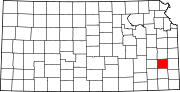
Allen County is a county located in the southeast portion of the U.S. state of Kansas. Its county seat and most populous city is Iola. As of the 2020 census, the population was 12,526. The county was named for William Allen, a U.S. Senator from Ohio and prominent supporter of westward expansion.

<span class="mw-page-title-main">Bassett, Kansas</span> City in Allen County, Kansas

Bassett is a city in Allen County, Kansas, United States. It is situated along the Neosho River. As of the 2020 census, the population of the city was 20.

<span class="mw-page-title-main">Elsmore, Kansas</span> City in Allen County, Kansas

Elsmore is a city in Allen County, Kansas, United States. As of the 2020 census, the population of the city was 50. The name Elsmore is a corruption of Elsinore, where Shakespeare's play Hamlet was set.

<span class="mw-page-title-main">Iola, Kansas</span> City in Allen County, Kansas

Iola is the county seat of Allen County, Kansas, United States. The city is situated along the Neosho River in southeast Kansas. As of the 2020 census, the population of the city was 5,396. It is named in honor of Iola Colborn.

<span class="mw-page-title-main">Parsons, Kansas</span> City in Labette County, Kansas

Parsons is a city in Labette County, Kansas, United States. As of the 2020 census, the population of the city was 9,600. It is the most populous city of Labette County, and the second-most populous city in the southeastern region of Kansas. It is home to Labette Community College and the Parsons State Hospital & Training Center.

<span class="mw-page-title-main">Tyro, Kansas</span> City in Montgomery County, Kansas

Tyro is a city in Montgomery County, Kansas, United States. As of the 2020 census, the population of the city was 177.

<span class="mw-page-title-main">Erie, Kansas</span> City in Neosho County, Kansas

Erie is a city in and the county seat of Neosho County, Kansas, United States, and situated in the valley of the Neosho River, about a mile Northeast of the river. As of the 2020 census, the population of the city was 1,047.

<span class="mw-page-title-main">Altoona, Kansas</span> City in Wilson County, Kansas

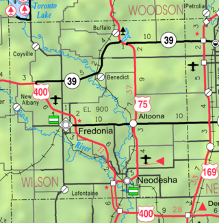
Altoona is a city in Wilson County, Kansas, United States, along the Verdigris River. As of the 2020 census, the population of the city was 354.

<span class="mw-page-title-main">Benedict, Kansas</span> City in Wilson County, Kansas

Benedict is a city in Wilson County, Kansas, United States, along the Verdigris River. As of the 2020 census, the population of the city was 69.

<span class="mw-page-title-main">Buffalo, Kansas</span> City in Wilson County, Kansas

Buffalo is a city in Wilson County, Kansas, United States. As of the 2020 census, the population of the city was 217.

<span class="mw-page-title-main">New Albany, Kansas</span> City in Wilson County, Kansas

New Albany is a city in Wilson County, Kansas, United States. As of the 2020 census, the population of the city was 57.

<span class="mw-page-title-main">Neosho Falls, Kansas</span> City in Woodson County, Kansas, United States

Neosho Falls is a city in Woodson County, Kansas, United States. As of the 2020 census, the population of the city was 134.

<span class="mw-page-title-main">Tompkinsville, Kentucky</span> City in Kentucky, United States

Tompkinsville is a home rule-class city in and the county seat of Monroe County, Kentucky, United States. The population was 2,309 at the 2020 census. The city was named after Vice President Daniel D. Tompkins who served under President James Monroe, for whom the county was named.

Octagon City is a ghost town in Allen County, Kansas, United States. It was a failed intentional community that was founded in 1856 about six miles (10 km) south of Humboldt, Kansas near the Neosho River. It was created by the Vegetarian Kansas Emigration Company, headed by prominent vegetarian Henry S. Clubb and entrepreneurs Charles DeWolfe and John McLaurin. The original intent was to build a vegetarian commune on the south side of the Neosho River, but investor interest in a non-vegetarian moral community was much higher and the decision was made to build Octagon City on the north side of the Neosho River to make the entire project sustainable. Members of Octagon City were under oath to educate their children and uphold a moral lifestyle.

Cofachique is a ghost town situated along the Neosho River near the present-day city of Iola in Allen County, Kansas, United States. Being the first town established in Allen County in 1855, it was the original county seat. However, within five years the greater part of the town was moved to the new town of Iola, while the old site of Cofachique became farm land. The town was named in honor of an Osage chief known as Cofachique, who is said to have been particularly helpful to early settlers, bringing aid to the distressed and homeless. The name "Cofachique" appears to have origins with the Cofachiqui tribe in South Carolina, who were Siouan speakers, and the Osage who settled this area were closely affiliated with the Siouan.

References

  1. 1 2 3 4 U.S. Geological Survey Geographic Names Information System: Humboldt, Kansas
  2. "2019 U.S. Gazetteer Files". United States Census Bureau. Retrieved July 24, 2020.
  3. 1 2 "Profile of Humboldt, Kansas in 2020". United States Census Bureau. Archived from the original on June 24, 2022. Retrieved June 23, 2022.
  4. "Humboldt". Allen County. Retrieved May 18, 2014.
  5. "History of Humboldt, Kansas" Archived 2006-08-16 at the Wayback Machine , HumboldtKS.com
  6. Blackmar, Frank W., ed. "Humboldt". Kansas: a cyclopedia of state history, embracing events, institutions, industries, counties, cities, towns, prominent persons, etc. ... Vol. I. Standard Pub. Co. (Chicago: 1912) pp. 879–880.
  7. Lieut. Col. Charles W. Blair, report to Capt. T. I. Hurd, The War of the Rebellion(Washington: Government Printing Office, 1896), Series I, Vol. XLVIII, Part II, p. 337.
  8. "Editor Humboldt Herald", The Humboldt Herald, May 12, 1865, p. 2.
  9. Watson Stewart, Personal Memoirs of Watson Stewart (Davenport, Iowa: February 25, 1904)
  10. Stewart, Personal Memoirs.
  11. "The Humboldt Raid", Fort Scott Democrat (Fort Scott, Kans.), September 21, 1861, p. 3.
  12. H. W. Signor, letter to George W. Martin, January 1, 1911, pp. 1-4 (in the Manuscript Div. of the Kansas State Historical Society, Topeka, Kans.)
  13. Signor, pp. 1-4.
  14. Nat Armel, "The Sacking and Burning of Humboldt", Humboldt Union, September 5, 1965, p. 4
  15. Stewart, "Sketches of Early History!", Humboldt Union, July 15, 1876, p. 4.
  16. Armel, p. 6
  17. Stewart, Personal Memoirs, p. 41.
  18. Genevieve and Harold Choguill, editors, A History of the Humboldt, Kansas, Community: 1855–1988 (Newton, Kans.: Mennonite Press, 1988), pp. 7-8
  19. Humboldt, Kansas, website.
  20. "Frederick H. Dyer, transcription by Susan Tortorelli, "17th Illinois Cavalry: Dyer's Regimental History,"". Archived from the original on November 25, 2011. Retrieved August 10, 2012.
  21. "US Gazetteer files 2010". United States Census Bureau. Archived from the original on July 2, 2012. Retrieved July 6, 2012.
  22. Climate Summary for Humboldt, Kansas
  23. "U.S. Census website". United States Census Bureau . Retrieved July 6, 2012.
  24. "U.S. Census website". United States Census Bureau . Retrieved January 31, 2008.
  25. "Biblesta Parade Humboldt, Kansas". www.biblesta.com. Retrieved January 18, 2016.
  26. "USD 258 Public Schools". Archived from the original on April 9, 2008. Retrieved November 27, 2007.

Further reading