
The 2004 Pacific hurricane season was unusual in that no tropical cyclones of at least tropical storm intensity made landfall, the first such occurrence since 1991. The season was also below-average in terms of named storms and hurricanes, near-average in terms of major hurricanes. The season officially began on May 15 in the eastern Pacific, and on June 1 in the central Pacific; it officially ended in both basins on November 30. These dates conventionally delimit the period during each year when a majority of tropical cyclones form. The season was reflected by an accumulated cyclone energy (ACE) index of 71 units.

The 1999 Pacific hurricane season was one of the least active Pacific hurricane seasons on record. The season officially began on May 15 in the Eastern Pacific, and on June 1 in the Central Pacific; in both basins, it ended on November 30. These dates conventionally delimit the period during which most tropical cyclones form in the northeastern Pacific Ocean. The first tropical cyclone of the season, Hurricane Adrian, developed on June 18, while the final storm of the season, Tropical Storm Irwin, dissipated on October 11. No storms developed in the Central Pacific during the season. However, two storms from the Eastern Pacific, Dora and Eugene, entered the basin, with the former entering as a hurricane and becoming the second farthest travelling Pacific hurricane on record.

The 1998 Pacific hurricane season was a fairly average Pacific hurricane season. Despite this, it had nine hurricanes and six major hurricanes, which was well above average. The season officially started on May 15 in the eastern Pacific and on June 1 in the central Pacific, and ended on November 30; these dates conventionally delimit the period during which most tropical cyclones form in that region. The first tropical cyclone developed on June 11, about ten days later than the normal start of the season. The final storm of the year, Hurricane Madeline, dissipated on October 20. Storm activity in the Central Pacific Hurricane Center's warning zone was low, with just one tropical depression observed in the region. Two tropical cyclones from the eastern Pacific also entered the central Pacific; the former did so as a hurricane.

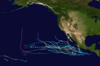
The 1995 Pacific hurricane season was the least active Pacific hurricane season since 1979, and marked the beginning of a multi-decade period of low activity in the basin. Of the eleven tropical cyclones that formed during the season, four affected land, with the most notable storm of the season being Hurricane Ismael, which killed at least 116 people in Mexico. The strongest hurricane in the season was Hurricane Juliette, which reached peak winds of 150 mph (240 km/h), but did not significantly affect land. Hurricane Adolph was an early-season Category 4 hurricane. Hurricane Henriette brushed the Baja California Peninsula in early September.

The 1993 Pacific hurricane season included more than double the average number of major hurricanes – Category 3 or stronger cyclones on the Saffir–Simpson scale. This activity was the result of an El Niño event, which is the main factor contributing to above-average activity across the Pacific basin. The season featured 15 named storms, 11 hurricanes, and 9 major hurricanes. While the number of named storms was near the long-term average, the number of hurricanes was above the average of 8, and the number of major hurricanes far exceeded the long-term average of 4. Seasonal activity began on May 17 and ended on November 8, within the confines of a traditional hurricane season which begins on May 15 in the East Pacific and June 1 in the Central Pacific. The season ends on November 30 in both basins. These dates conventionally delimit the period during each year when most tropical cyclones form.

The 1992 Pacific hurricane season is the most active Pacific hurricane season on record, featuring 27 named storms, and the second-costliest Pacific hurricane season in history, behind the 2013 season. The season also produced the second-highest ACE value on record in the basin, only surpassed by the 2018 season. The season officially started on May 15 in the eastern Pacific, and on June 1 in the central Pacific, and lasted until November 30. These dates conventionally delimit the period of each year when most tropical cyclones form in the northeastern Pacific Ocean. However, these bounds were easily exceeded when Hurricane Ekeka formed on January 28 and again a couple months later with Tropical Storm Hali.

The 1991 Pacific hurricane season was a near-average Pacific hurricane season. The worst storm this year was Tropical Storm Ignacio, which killed 23 people in Mexico and injured 40 others. Elsewhere, Hurricane Fefa caused flooding in Hawaii. Hurricane Kevin was the strongest system of the season and became the then longest-lasting hurricane in the eastern north Pacific basin at the time, and Hurricane Nora was the strongest November storm to that point. The season officially started on May 15, 1991, in the eastern Pacific, and on June 1, 1991, in the central Pacific. It lasted until November 30, 1991, in both basins. These dates conventionally delimit the period of each year when most tropical cyclones form in the northeastern Pacific Ocean.

The 1990 Pacific hurricane season was a very active season which observed 21 named storms within the basin. The season also produced the fourth highest ACE index value on record. The season was officially started on May 15 in the eastern Pacific, and on June 1 in the central Pacific, and lasted until November 30. These dates conventionally delimit the period of each year when most tropical cyclones form in the northeastern Pacific Ocean. However, the formation of tropical cyclones is possible at any time of the year, as illustrated in 1990 by the formation of the season's first named storm, Hurricane Alma, on May 12. At the time, this was the earliest formation of a tropical storm on record in the eastern Pacific

The 1988 Pacific hurricane season was the least active Pacific hurricane season since 1981. It officially began May 15, in the eastern Pacific, and June 1, in the central Pacific and lasted until November 30. These dates conventionally delimit the period of each year when most tropical cyclones form in the northeastern Pacific Ocean. The first named storm, Tropical Storm Aletta, formed on June 16, and the last-named storm, Tropical Storm Miriam, was previously named Hurricane Joan in the Atlantic Ocean before crossing Central America and re-emerging in the eastern Pacific; Miriam continued westward and dissipated on November 2.
The 1987 Pacific hurricane season was the last year in which the Eastern Pacific Hurricane Center was the primary warning center for tropical cyclones in the eastern Pacific Ocean. The season officially started May 15, 1987, in the eastern Pacific, and June 1, 1987, in the central Pacific, and lasted until November 30, 1987. These dates conventionally delimit the period of each year when the vast majority of tropical cyclones form in the northeastern Pacific Ocean.

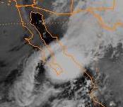
Hurricane Ismael was a weak, but deadly Pacific hurricane that killed over one hundred people in northern Mexico in September of the 1995 Pacific hurricane season. It developed from a persistent area of deep convection on September 12, and steadily strengthened as it moved to the north-northwest. Ismael attained hurricane status on September 14 while located 210 miles (340 km) off the coast of Mexico. It continued to the north, and after passing a short distance east of Baja California it made landfall on Topolobampo in the state of Sinaloa with winds of 80 mph (130 km/h). Ismael rapidly weakened over land, and dissipated on September 16 over northwestern Mexico. The remnants entered the United States and extended eastward into the Mid-Atlantic States.

Hurricane Nora was the first tropical cyclone to enter the Continental United States from the Pacific Ocean since Hurricane Lester in 1992. Nora was the fourteenth named tropical cyclone and the seventh hurricane of the 1997 Pacific hurricane season. The September storm formed off the Pacific coast of Mexico, and aided by waters warmed by the 1997–98 El Niño event, eventually peaked at Category 4 intensity on the Saffir–Simpson hurricane scale.
Hurricane Lester was the first Pacific tropical cyclone to enter the United States as a tropical storm since 1967. The fourteenth named storm and eighth hurricane of the 1992 Pacific hurricane season, Lester formed on August 20 from a tropical wave southwest of Mexico. The tropical storm moved generally northwestward while steadily intensifying. After turning to the north, approaching the Mexican coast, Lester attained hurricane status. The hurricane reached peak winds of 85 mph (137 km/h) before making landfall on west-central Baja California. The system weakened while moving across the peninsula and then over northwestern Mexico. Not long after entering Arizona, Lester weakened to a tropical depression, and degenerated into an extratropical low on August 24, 1992, over New Mexico. The storm's remnants later merged with the remnants of Hurricane Andrew and another frontal system on August 29.

The 2010 Pacific hurricane season was the least active Pacific hurricane season on record, tied with 1977. The season had the second-fewest ACE units on record, as many of the storms were weak and short-lived. Additionally, the season saw only 3 of the named storms strengthen into hurricanes. However, of those, 2 became major hurricanes, and 1, Celia, reached Category 5 intensity on the Saffir-Simpson scale. The season officially began on May 15 in the eastern North Pacific and on June 1 in the central North Pacific. It ended in both regions on November 30. These dates, adopted by convention, historically describe the period in each year when most tropical cyclogenesis occurs in these regions of the Pacific. However, the formation of tropical cyclones is possible at any time of the year, as evidenced by the formation of Tropical Storm Omeka on December 19.

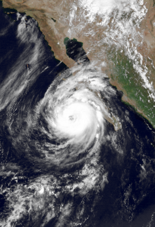
Hurricane Juliette was the strongest hurricane and final tropical cyclone of the inactive 1995 Pacific hurricane season. The tenth named storm of the season, Juliette formed on September 16 from a tropical wave off the southwest coast of Mexico. For the majority of its track, the storm moved toward the west-northwest, and Juliette quickly intensified to major hurricane status. On September 20, the hurricane reached peak winds of 150 mph (240 km/h). Later it turned toward the northeast, briefly threatening the Baja California Peninsula, although the hurricane never affected land.
Tropical Storm Rachel was the only tropical cyclone to make landfall during the 1990 Pacific hurricane season. The twenty-fourth tropical depression and eighteenth named storm, Rachel developed on September 27 from a tropical wave southwest of mainland Mexico. After becoming a tropical depression, the system tracked slowly southwestward and eventually curved northwestward. The depression intensified into a tropical storm after three days and was named Rachel by the National Hurricane Center. Rachel continued to steadily strengthen, and peaked as a strong 65 mph (100 km/h) tropical storm on October 2. After attaining peak intensity, Rachel re-curved to make a landfall in southern Baja California Sur and again in the Mexican Mainland on October 3. The storm produced heavy rainfall across northern Mexico and the Southwestern United States. Thousands of people were left homeless and 18 fatalities were reported.

Tropical Storm Zeke was the final named storm of the record-breaking 1992 Pacific hurricane season. Forming out of a tropical wave on October 25, Zeke began as a disorganized depression. Tracking west-northwestward, the system gradually developed organized convection and intensified into a tropical storm. However, it soon entered a high wind shear environment, causing Zeke to weaken to a tropical depression. The following day, the storm re-intensified despite unfavorable conditions and later attained peak winds of 50 mph (80 km/h) on October 29. Rapid weakening followed shortly thereafter as convection dissipated and the center became exposed. During the afternoon of October 30, Zeke degenerated into a remnant low pressure system and dissipated several days later several hundred miles south of Baja California Sur.

Tropical Storm Ignacio was a strong tropical storm that deluged the Mexican coast with heavy rains. The 9th named storm and 11th tropical cyclone of the 1991 Pacific hurricane season, the system formed from two tropical waves. The pair moved across the Atlantic during the first ten days of September. The second of the two spawned Tropical Storm Erika in the eastern Atlantic. Emerging into the eastern Pacific between the September 10 and September 12, an area of thunderstorms developed southeast of an upper level cyclone off the southern tip of Baja California Sur due to the interaction of the upper cyclone with the pair of tropical waves. By the September 15, the thunderstorm activity organized into bands, indicating the presence of a new tropical depression, the eleventh of the season. The cyclone moved north-northwest due to steering around the upper cyclone, and became a tropical storm by noon on the September 16. Once the upper cyclone moved away from Ignacio, its motion towards the Mexican coast stopped on September 17, and it executed a slow anticyclonic loop that would be completed late on the September 18. Proximity to land and west to southwesterly vertical wind shear weakened the cyclone, and Ignacio regained tropical depression status late on the September 18. The system dissipated as a tropical cyclone that night, and its remnants moved west-southwest into the tropical Pacific, occasionally flaring up new convection over the succeeding couple days.

