Hurricane Genevieve (2014)

Last updated
Map key
  Tropical depression (≤38 mph, ≤62 km/h)
  Tropical storm (39–73 mph, 63–118 km/h)
  Category 1 (74–95 mph, 119–153 km/h)
  Category 2 (96–110 mph, 154–177 km/h)
  Category 3 (111–129 mph, 178–208 km/h)
  Category 4 (130–156 mph, 209–251 km/h)
  Category 5 (≥157 mph, ≥252 km/h)
  Unknown
Storm type
Disc Plain black.svg Tropical cyclone
Solid black.svg Subtropical cyclone
ArrowUp.svg Extratropical cyclone, remnant low, tropical disturbance, or monsoon depression

The National Hurricane Center (NHC) began to monitor a tropical wave associated with a few showers and thunderstorms, moving westward off the coast of northern Central America on July 17. [1] Four days later, thunderstorm activity became more concentrated; [2] by July 22, the area of low-pressure became better organized. [3] On July 23, the NHC noted that the system could become a tropical depression within the next two days; [4] however, they also noted that wind shear could increase within a couple of days. [5] Following an increase of deep convection developing near the center as well as the collection of ASCAT data showing an area of tropical storm-force winds, the NHC upgraded the system to Tropical Storm Genevieve on July 25. [6] Shortly thereafter, the system attained its initial peak intensity of 45 mph (72 km/h). [7]

Tropical Storm Genevieve at its initial peak intensity on July 25 Genevieve 2014-07-25 2205Z.jpg
Tropical Storm Genevieve at its initial peak intensity on July 25

Shortly afterward, increased wind shear took its toll on the system, causing Genevieve to lose its organization as it continued westward, under the influence of a subtropical ridge and the Intertropical Convergence Zone. [8] After the low-level center of circulation was exposed and became separated from the deep convection, the NHC subsequently downgraded it to a tropical depression on July 26. [9] Although deep convection increased near the center early on the next day, Genevieve continued to battle westerly shear when crossing 140°W, moving into the waters monitored by the Central Pacific Hurricane Center (CPHC). [10] Due to the lack of deep convection, the CPHC indicated that Genevieve had become a remnant low early on July 28, as only a low-level cloud swirl remained. However, the CPHC noted the possibility of re-development since shear was forecast to decrease. [11]

Roughly 36 hours later, the remnants of Genevieve regenerated into a tropical depression to the southeast of the main Hawaiian Islands. [12] The system briefly became better organized on July 30, prompting the CPHC to forecast the storm would re-intensify into a tropical storm. [13] However, by the end of the day, the low-level circulation center had become displaced to the east of the deep convection due to increased southeasterly shear [14] and infiltration of dry air. [15] By 21:00 UTC July 31, the CPHC reported that Genevieve had once again degenerated to a remnant low, as only an isolated area of deep convection remained west of the center. [16]

Intensification and peak intensity

The remnants of Genevieve continued to travel in a generally westward direction, moving into an environment more conducive for tropical cyclogenesis, and on the afternoon of August 2, Genevieve regenerated into a tropical depression, as the storm reacquired deep convection and its upper-level outflow pattern improved. [17] By 21:00 UTC the same day, Genevieve reacquired tropical storm intensity, continuing to travel westward around the subtropical ridge to its north, [18] but only six hours later, the CPHC downgraded Genevieve into a tropical depression. [19] Deep convection near the center waxed and waned several times, but Genevieve failed to re-intensify. [20] After moving west-southwest, Genevieve turned west-northwest on August 4 as it continued to track around the ridge to its north. [21]

Despite moderate wind shear, convection soon wrapped around the southeastern side of the low-level circulation. [22] By 21:00 UTC on August 5, the CPHC upgraded the system to a tropical storm, despite continued wind shear. [23] Wind shear quickly decreased, triggering a period of rapid intensification. [24] By the afternoon of August 6, Genevieve intensified to a low-end Category 1 hurricane; the system also developed a central dense overcast and well-organized banding around the newly-developed eye. Traversing over very warm sea surface temperatures, [25] the intensification rate accelerated that evening. Based on advanced Dvorak technique estimates of 130 mph (210 km/h) as well as the presence of a very well-defined eye surrounded by very cold cloud tops, the CPHC upgraded the hurricane into Category 3 intensity on the Saffir-Simpson Hurricane Wind Scale early on the next day. [26]

Infrared loop of Genevieve after it crossed the International Date Line Genevieve 2014-08-07 1101-1732Z (infrared).gif
Infrared loop of Genevieve after it crossed the International Date Line

Genevieve crossed the International Date Line at 06:00 UTC on August 7, entering the area of responsibility of the RSMC Tokyo operated by the Japan Meteorological Agency (JMA). Thus, the JMA immediately recognized Genevieve as a typhoon with ten-minute maximum sustained winds at 115 mph (185 km/h). [27] The Joint Typhoon Warning Center (JTWC) also upgraded Genevieve to a super typhoon, based on the compact and symmetric ring of uniform convection embedded with a 14 mi (23 km) eye, as well as excellent poleward outflow into the strong tropical upper tropospheric trough (TUTT) positioned to the north and northeast. [28] Only six hours later, the JTWC reported that Genevieve had reached Category 5 status with one-minute sustained winds at 160 mph (260 km/h), when a microwave imagery revealed a 69 mi (111 km) diameter eyewall with a convective band over the south quadrant. [29] As Genevieve continued to remain in a favorable environment with radial outflow and low vertical wind shear, the JMA indicated that the typhoon about 760 mi (1,220 km) east-southeast of Wake Island had reached its peak intensity late on August 7, with ten-minute maximum sustained winds at 125 mph (201 km/h). [30]

Demise

During the morning of August 8, Genevieve started to track northward along the western periphery of a deep-layered subtropical ridge positioned to the east and northeast. Although the typhoon remained compact at noon, more fragmented deep convective banding revealed that Genevieve had begun a weakening trend. [31] As the result, the JTWC downgraded Genevieve to a typhoon late on the same day, due to warmer convection surrounding the system. [32] Early on August 9, Genevieve accelerated north-northeastward, and it began to encounter increasing vertical wind shear of 35 mph (56 km/h) with subsidence along the western periphery and weakening outflow into the TUTT. Therefore, the eye of the typhoon became cloud-filled, while the deepest convection around the core was also becoming warmer. [33] The system began to track north-northwestward in the afternoon, when the cold dense overcast has decreased in size and become less symmetric. [34]

Severe Tropical Storm Genevieve on August 11 Genevieve 2014-08-11 0130Z.jpg
Severe Tropical Storm Genevieve on August 11

Genevieve reformed a 17 mi (27 km) eye with more symmetric and organized convection for short time early on August 10, but the eye disappeared very soon as the system elongated more. [35] Upper-level analysis indicated a complex environment— an anticyclone located to the southeast, a TUTT cell to the west, and a second anticyclone to the north. The TUTT cell and the first anticyclone caused strong upper-level southwestern flow and moderate vertical wind shear over the system, but the issues were offset by the quick speed of the typhoon. [36] Tracking northwestward, Genevieve crossed 30°N at noon and began to encounter unfavorable sea surface temperatures less than 79 °F (26 °C). At the same time, a digging trough was expanding the region of subsidence which isolated the core from the tropical moisture along the equatorward periphery. [37] Later, deep convection along the tightly-wrapped low-level circulation center of the typhoon rapidly diminished as dry air surrounded the system. [38]

Late on August 10, the JMA downgraded Genevieve to a severe tropical storm about 670 mi (1,080 km) west-northwest of Midway Atoll, and the JTWC downgraded it to a tropical storm early on the next day. [39] [40] Dry air, cool ocean temperatures and a rapid weakening of the linkage to tropical moisture made deep convection over the storm almost completely dissipate. This process was hastened by the disintegration of the TUTT cell which had helped to enhance equatorward outflow. [41] Under the combination of many unfavorable environmental factors, the JMA downgraded the rapidly weakening system to a tropical storm, when it started to move west-northwestward and slowed down at noon. [42] Owing to diminished convection associated with a weak low-level circulation center, the JTWC issued its final warning and downgraded Genevieve to a tropical depression late on the same day. [43]

After the JMA downgraded Genevieve to a tropical depression at 06:00 UTC on August 12, the system drifted westward and then northwestward very slowly until it accelerated northeastward late on August 13. [44] [45] The JMA reported that Genevieve had dissipated as a tropical depression before noon on August 14; [46] [47] however, the Ocean Prediction Center indicated that this post-tropical cyclone crossed the International Date Line and entered the Central North Pacific Ocean again late on the same day. [48] The remnants of Genevieve were eventually absorbed by another extratropical cyclone before noon on August 15. [49] [50]

See also

Related Research Articles

<span class="mw-page-title-main">2002 Pacific hurricane season</span>

The 2002 Pacific hurricane season was a near–average season which produced fifteen named storms. Eight hurricanes formed, including a record-equaling three Category 5 hurricanes, a record it shares with the 1994 and 2018 seasons. It was also a near-average season in terms of accumulated cyclone energy (ACE), having an ACE of 125. The season officially began on May 15, 2002 in the East Pacific Ocean, and on June 1, 2002 in the Central Pacific; both ended on November 30. These dates conventionally delimit the period of each year when most tropical cyclone formation occurs in these regions of the Pacific. The first system of the 2002 season, Hurricane Alma, formed on May 24, and the last, Tropical Depression Sixteen-E, dissipated on November 16.

<span class="mw-page-title-main">1996 Pacific hurricane season</span>

The 1996 Pacific hurricane season had below normal tropical cyclone activity, producing 9 tropical storms, of which 5 became hurricanes, with 2 of those intensifying into major hurricanes. With an Accumulated cyclone energy (ACE) index of 53.9, the season ranks among the least intense Pacific hurricane seasons on record. It officially began May 15, 1996, in the eastern north Pacific and on June 1, 1996, in the central north Pacific. It ended on November 30, 1996. These dates conventionally delimit the period of each year when most tropical cyclones form in the northeastern Pacific Ocean. The season slightly exceeded these bounds when tropical storm One-E formed on May 13.

<span class="mw-page-title-main">2007 Pacific hurricane season</span>

The 2007 Pacific hurricane season was a well below-average Pacific hurricane season, featuring only one major hurricane. The season officially started on May 15 in the eastern Pacific and on June 1 in the central Pacific, and ended on November 30; these dates conventionally delimit the period during which most tropical cyclones form in the region. The first tropical cyclone of the season, Alvin, developed on May 27, while the final system of the year, Kiko, dissipated on October 23. Due to unusually strong wind shear, activity fell short of the long-term average, with a total of 11 named storms, 4 hurricanes, and 1 major hurricane. At the time, 2007 featured the second-lowest value of the Accumulated cyclone energy (ACE) index since reliable records began in 1971. Two tropical cyclones – Cosme and Flossie – crossed into the central Pacific basin during the year, activity below the average of 4 to 5 systems.

<span class="mw-page-title-main">Hurricane Ioke</span> Category 5 Pacific hurricane and typhoon in 2006

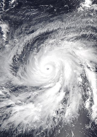
Hurricane Ioke, also referred to as Typhoon Ioke, was a record-breaking, long-lived and extremely powerful storm that traversed the Pacific for 17 days, reaching the equivalent of Category 5 status on the Saffir–Simpson hurricane scale on three different occasions. It was the most intense hurricane ever recorded in the Central Pacific, as well as the fifth-most intense Pacific hurricane on record, tied with 1973's Hurricane Ava. It also generated the most accumulated cyclone energy for a single storm, until Cyclone Freddy surpassed its record in 2023. Ioke was the ninth named storm, fifth hurricane, and third major hurricane of the active 2006 Pacific hurricane season.

<span class="mw-page-title-main">Hurricane Dora (1999)</span> Category 4 Pacific hurricane in 1999

Hurricane Dora was one of few tropical cyclones to track across all three north Pacific basins and the first since Hurricane John in 1994. The fourth named storm, third hurricane, and second major hurricane of the 1999 Pacific hurricane season, Dora developed on August 6 from a tropical wave to the south of Mexico. Forming as a tropical depression, the system gradually strengthened and was upgraded to Tropical Storm Dora later that day. Thereafter Dora began heading in a steadily westward direction, before becoming a hurricane on August 8. Amid warm sea surface temperatures and low wind shear, the storm continued to intensify, eventually peaking as a 140 mph (220 km/h) Category 4 hurricane on August 12.

<span class="mw-page-title-main">Hurricane Ekeka</span> Category 3 Pacific hurricane in 1992

Hurricane Ekeka was the most intense off-season tropical cyclone on record in the northeastern Pacific basin. The first storm of the 1992 Pacific hurricane season, Ekeka developed on January 28 well to the south of Hawaii. It gradually intensified to reach major hurricane status on February 2, although it subsequently began to weaken due to unfavorable high wind shear. It crossed the International Date Line as a weakened tropical storm, and shortly thereafter degraded to tropical depression status. Ekeka continued westward, passing through the Marshall Islands and later over Chuuk State, before dissipating on February 9 about 310 miles (500 km) off the north coast of Papua New Guinea. The storm did not cause any significant damage or deaths.

<span class="mw-page-title-main">Hurricane Felicia (2009)</span> Category 4 Pacific hurricane in 2009

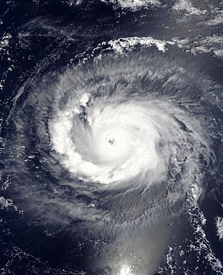
Hurricane Felicia was a powerful Category 4 Pacific hurricane whose remnants caused significant rainfall and flooding on the Hawaiian Islands. Felicia was the third strongest tropical cyclone of the 2009 Pacific hurricane season, as well as the strongest storm to exist in the eastern Pacific at the time since Hurricane Daniel in 2006. Forming as a tropical depression on August 3, the storm supported strong thunderstorm activity and quickly organized. It became a tropical storm over the following day, and subsequently underwent rapid deepening to attain hurricane status. Later that afternoon, Felicia developed a well-defined eye as its winds sharply rose to major hurricane-force on the Saffir–Simpson scale. Further strengthening ensued, and Felicia peaked in intensity as a Category 4 hurricane with sustained winds of 145 mph (233 km/h) and a barometric pressure of 935 mbar. After reaching this strength, unfavorable conditions, such as wind shear, began to impact the storm while it took on a northwestward path. Henceforth, Felicia slowly weakened for several days; by August 8 it had been downgraded to a Category 1 hurricane, once again becoming a tropical storm the next day. It retraced westward towards Hawaii on August 10, all the while decreasing in organization. On August 11, Felicia weakened to tropical depression status, and soon degenerated into remnant low just prior to passing over the islands.

<span class="mw-page-title-main">2009 Pacific hurricane season</span>

The 2009 Pacific hurricane season was the most active Pacific hurricane season since 1997. The season officially started on May 15 in the East Pacific Ocean, and on June 1 in the Central Pacific; they both ended on November 30. These dates conventionally delimit the period of each year when most tropical cyclones form in the Eastern Pacific tropical cyclone basin; however, tropical cyclone formation is possible at any time of the year. The first system of the season, Tropical Depression One-E, developed on June 18, and the last, Hurricane Neki, dissipated on October 27, keeping activity well within the bounds of the season.

<span class="mw-page-title-main">Hurricane Neki</span> Category 3 Pacific hurricane in 2009

Hurricane Neki was the final tropical cyclone of the 2009 Pacific hurricane season. It developed on October 18 as an unusually large disturbance from a trough south of Hawaii. Moving northwestward, it organized only slowly at first due to its large size. After reaching hurricane status on October 21, Neki intensified at a much faster rate and peaked with winds of 125 mph (205 km/h). It later turned to the north and north-northeast and weakened due to hostile conditions. While passing through the Papahānaumokuākea Marine National Monument, Neki was downgraded to a tropical storm after the center became exposed from the deepest convection. It caused little impact in the island chain. After stalling and executing a small loop, Neki resumed its northward track and dissipated on October 27.

<span class="mw-page-title-main">2013 Pacific hurricane season</span>

The 2013 Pacific hurricane season was an above average Pacific hurricane season with 21 tropical cyclones forming. Of these, 20 became named storms – 18 in the Eastern Pacific basin, and 2 in the Central Pacific basin. Of the 18 named storms in the east, 9 became hurricanes, with one, Raymond, becoming the season's only major hurricane. In the central, neither named storm became a hurricane. It was also a below-normal season in terms of Accumulated cyclone energy (ACE), as many of its systems were weak and short-lived. The season officially began on May 15 in the Eastern Pacific and started on June 1 in the Central Pacific; both ended on November 30. These dates conventionally delimit the period of each year when most tropical development occurs in these North Pacific basins. The first cyclone, Tropical Storm Alvin, formed on May 15, and the last, Tropical Storm Sonia, dissipated on November 4.

<span class="mw-page-title-main">2014 Pacific hurricane season</span>

The 2014 Pacific hurricane season was the fifth-busiest season since reliable records began in 1949, alongside the 2016 season. The season officially started on May 15 in the East Pacific Ocean, and on June 1 in the Central Pacific; they both ended on November 30. These dates conventionally delimit the period of each year when most tropical cyclones form in the Pacific basin.

<span class="mw-page-title-main">Hurricane Uleki</span> Category 3 Pacific hurricane in 1988

Hurricane Uleki, also referred as Typhoon Uleki, was a long-lived tropical cyclone in August–September 1988 that had minimal effects on land. Originating from a disturbance in the Intertropical Convergence Zone in late-August, Uleki was identified as a tropical depression well to the southeast of Hawaii on August 28. Steady organization ensued as it moved west, becoming a tropical storm on August 30 and a hurricane on August 31. Rapid intensification took place thereafter and the storm reached its peak intensity on September 2 as a Category 3 on the Saffir–Simpson hurricane wind scale. hurricane hunters investigating the cyclone found peak winds of 125 mph (201 km/h) and a barometric pressure of 957 mbar. Thereafter, Uleki stalled for two days to the southwest of Hawaii, resulting in heavy surf across the state. The dangerous swells killed two people on Oahu.

<span class="mw-page-title-main">2013–14 South-West Indian Ocean cyclone season</span> Event of tropical cyclone formation in the Indian Ocean

The 2013–14 South-West Indian Ocean cyclone season was an above-average event in tropical cyclone formation. The season officially began on July 1, 2013, though the first tropical system designated by Météo-France was a short-lived tropical disturbance that developed on July 8. However, the first named storm was Cyclone Amara in December. Bruce was the first very intense tropical cyclone since Edzani in 2010, which originated from the Australian region. The strongest system of the cyclone season was Hellen, also one of the most intense tropical cyclones over the Mozambique Channel. The season officially ended on June 30, 2014

<span class="mw-page-title-main">Tropical Storm Flossie (2013)</span> Pacific tropical storm in 2013

Tropical Storm Flossie yielded stormy weather to Hawaii in late July 2013. The sixth tropical cyclone and named storm of the annual hurricane season, Flossie originated from a tropical wave that emerged off the western coast of Africa on July 9. Tracking westward across the Atlantic with little development, it passed over Central America and into the eastern Pacific Ocean on July 18, where favorable environmental conditions promoted steady organization. By 0600 UTC on July 25, the wave acquired enough organization to be deemed a tropical depression; it intensified into a tropical storm six hours later. Continuing westward, Flossie attained peak winds of 70 mph (110 km/h) on July 27 before entering the central Pacific Ocean. There, unfavorable upper-level winds established a weakening trend; on July 30, Flossie weakened to a tropical depression, and by 1200 UTC that same day, the storm degenerated into a remnant low, northeast of Kauai.

<span class="mw-page-title-main">Hurricane Iselle</span> Category 4 Pacific hurricane in 2014

Hurricane Iselle was the strongest tropical cyclone to make landfall on the Big Island of Hawaii in recorded history. The tenth named storm, fifth hurricane, and fourth major hurricane of the 2014 hurricane season, Iselle developed from an area of disturbed weather southwest of Mexico on July 31, 2014. Assuming a west-northwest course that it would maintain throughout its existence, generally favorable atmospheric conditions allowed for gradual strengthening, with the cyclone attaining hurricane status a day after formation. Continued strengthening progressed for several days up until August 4, when Iselle reached peak intensity with maximum sustained winds of 140 mph (220 km/h) and a minimum barometric pressure of 947 mbar, making it a Category 4 hurricane. Thereafter, Iselle encountered hostile environmental conditions and quickly weakened before making landfall on the Big Island on August 8 as a moderate tropical storm. Its passage over the island disrupted the cyclone, and Iselle later dissipated on August 9.

<span class="mw-page-title-main">Typhoon Halola</span> Pacific typhoon in 2015

Typhoon Halola, known in the Philippines as Typhoon Goring, was a small but long-lived tropical cyclone in July 2015 that traveled 7,640 km (4,750 mi) across the Pacific Ocean. The fifth named storm of the 2015 Pacific hurricane season, Halola originated from a Western Pacific monsoon trough that had expanded into the Central Pacific by July 5. Over the next several days, the system waxed and waned due to changes in wind shear before organizing into a tropical depression on July 10 while well southwest of Hawaii. The depression strengthened into Tropical Storm Halola on the next day as it traveled westward. Halola crossed the International Date Line on July 13 and entered the Western Pacific, where it was immediately recognized as a severe tropical storm. The storm further strengthened into a typhoon over the next day before encountering strong wind shear on July 16, upon which it quickly weakened into a tropical depression as it passed south of Wake Island. However, the shear relaxed on July 19, allowing Halola to reintensify. On July 21, Halola regained typhoon status and later peaked with 10-minute sustained winds of 150 km/h (93 mph) and a minimum pressure of 955 hPa. From July 23 onward, increasing wind shear and dry air caused Halola to weaken slowly. The system fell below typhoon intensity on July 25 as it began to recurve northwards. Halola made landfall over Kyushu on July 26 as a tropical storm and dissipated in the Tsushima Strait shortly after.

<span class="mw-page-title-main">Hurricane Hector (2018)</span> Category 4 Pacific hurricane in 2018

Hurricane Hector was a powerful and long-lasting tropical cyclone that traversed the Pacific Ocean during late July and August 2018. Hector was the eighth named storm, fourth hurricane, and third major hurricane of the 2018 Pacific hurricane season. It originated from a disturbance that was located north of South America on July 22. The disturbance tracked westward and entered the eastern Pacific around July 25. It gradually organized over the next several days, becoming a tropical depression at 12:00 UTC on July 31. The system was upgraded into a tropical storm about 12 hours later and received the name Hector. Throughout most of its existence, the cyclone traveled due west or slightly north of west. A favorable environment allowed the fledgling tropical storm to rapidly intensify to its initial peak as a Category 2 hurricane by 18:00 UTC on August 2. Wind shear caused Hector to weaken for a brief period before the storm began to strengthen again. Hector reached Category 3 status by 00:00 UTC on August 4 and went through an eyewall replacement cycle soon after, which caused the intensification to halt. After the replacement cycle, the cyclone continued to organize, developing a well-defined eye surrounded by cold cloud tops.

<span class="mw-page-title-main">Hurricane Walaka</span> Category 5 Pacific hurricane in 2018

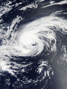
Hurricane Walaka was a Category 5 hurricane that brought high surf and a powerful storm surge to the Hawaiian Islands. Walaka was the nineteenth named storm, twelfth hurricane, eighth major hurricane, and second Category 5 hurricane of the 2018 Pacific hurricane season.

<span class="mw-page-title-main">Hurricane Kilo</span> Category 4 Pacific hurricane and typhoon in 2015

Hurricane Kilo, also referred to as Typhoon Kilo, was a powerful and long-lived tropical cyclone that traveled more than 4,000 miles (6,400 kilometers) from its formation point southeast of the Hawaiian Islands to its extratropical transition point to the northeast of Japan. Affecting areas from Hawaii to the Russian Far East along its long track, Kilo was the third of a record eight named storms to develop in the North Central Pacific tropical cyclone basin during the 2015 Pacific hurricane season.

<span class="mw-page-title-main">Hurricane Dora (2023)</span> Category 4 Pacific hurricane and typhoon in 2023

Hurricane Dora, also known as Typhoon Dora, was a long‑lived and powerful tropical cyclone that tracked across all three North Pacific tropical cyclone basins in August 2023. The fourth named storm, fourth hurricane, and second major hurricane of the 2023 Pacific hurricane season, Dora developed on July 31, from a tropical wave that had crossed over Central America from the North Atlantic, and became a tropical storm early the following day. During August 2–3, the system rapidly intensified to Category 4 strength. The same day, Dora moved into the Central Pacific basin from the East Pacific basin. Dora's annular structure deteriorated, leaving the system susceptible to dry air intrusions, and the hurricane passed south of Johnston Island. Dora weakened to Category 3 strength on the morning of August 10.

References

  1. Tropical Weather Discussion 1605 UTC Thu Jul 17 2014. National Hurricane Center (Report). Miami, Florida: National Oceanic and Atmospheric Administration. July 17, 2014. Archived from the original on August 12, 2014. Retrieved August 6, 2014.
  2. Daniel Brown (July 21, 2014). Tropical Weather Outlook. National Hurricane Center (Report). Miami, Florida: National Oceanic and Atmospheric Administration. Archived from the original on August 12, 2014. Retrieved August 6, 2014.
  3. Tropical Weather Outlook 11:00 pm PDT Tue Jul 22 2014. National Hurricane Center (Report). Miami, Florida: National Oceanic and Atmospheric Administration. July 23, 2014. Archived from the original on August 12, 2014. Retrieved August 6, 2014.
  4. Eric S. Blake (July 23, 2014). Tropical Weather Outlook. National Hurricane Center (Report). Miami, Florida: National Oceanic and Atmospheric Administration. Archived from the original on August 12, 2014. Retrieved August 6, 2014.
  5. Eric S. Blake (July 24, 2014). Tropical Weather Outlook. National Hurricane Center (Report). Miami, Florida: National Oceanic and Atmospheric Administration. Archived from the original on August 12, 2014. Retrieved August 6, 2014.
  6. Robbie J. Berg (July 25, 2014). Tropical Storm Genevieve Discussion Number 1. National Hurricane Center (Report). Miami, Florida: National Oceanic and Atmospheric Administration. Archived from the original on July 31, 2014. Retrieved August 6, 2014.
  7. Lixion A. Avila (July 25, 2014). Tropical Storm Genevieve Discussion Number 2. National Hurricane Center (Report). Miami, Florida: National Oceanic and Atmospheric Administration. Archived from the original on August 12, 2014. Retrieved August 15, 2014.
  8. Robbie J. Berg (July 26, 2014). Tropical Storm Genevieve Discussion Number 5. National Hurricane Center (Report). Miami, Florida: National Oceanic and Atmospheric Administration. Archived from the original on August 12, 2014. Retrieved August 7, 2014.
  9. Lixion A. Avila (July 26, 2014). Tropical Depression Genevieve Discussion Number 6. National Hurricane Center (Report). Miami, Florida: National Oceanic and Atmospheric Administration. Archived from the original on August 12, 2014. Retrieved August 7, 2014.
  10. John P. Cangialosi (July 26, 2014). Tropical Depression Genevieve Discussion Number 9. National Hurricane Center (Report). Miami, Florida: National Oceanic and Atmospheric Administration. Archived from the original on August 12, 2014. Retrieved August 7, 2014.
  11. Thomas Birchard (July 26, 2014). Post-Tropical Cyclone Genevieve Discussion Number 12. Central Pacific Hurricane Center (Report). Honolulu, Hawaii: National Oceanic and Atmospheric Administration. Archived from the original on August 12, 2014. Retrieved August 7, 2014.
  12. Robert Burke (July 29, 2014). Tropical Depression Genevieve Discussion Number 13. Central Pacific Hurricane Center (Report). Honolulu, Hawaii: National Oceanic and Atmospheric Administration. Archived from the original on August 12, 2014. Retrieved August 7, 2014.
  13. Jeffrey Powell; Chris Jacobson (July 30, 2014). Tropical Depression Genevieve Discussion Number 15. Central Pacific Hurricane Center (Report). Honolulu, Hawaii: National Oceanic and Atmospheric Administration. Retrieved August 7, 2014.
  14. Robert Burke (July 30, 2014). Tropical Depression Genevieve Discussion Number 18. Central Pacific Hurricane Center (Report). Honolulu, Hawaii: National Oceanic and Atmospheric Administration. Archived from the original on August 12, 2014. Retrieved August 7, 2014.
  15. Sam Houston (July 31, 2014). Tropical Depression Genevieve Discussion Number 19. Central Pacific Hurricane Center (Report). Honolulu, Hawaii: National Oceanic and Atmospheric Administration. Archived from the original on August 12, 2014. Retrieved August 8, 2014.
  16. Robert Burke (July 31, 2014). Post-Tropical Cyclone Genevieve Discussion Number 21. Central Pacific Hurricane Center (Report). Honolulu, Hawaii: National Oceanic and Atmospheric Administration. Archived from the original on August 12, 2014. Retrieved August 8, 2014.
  17. Sam Houston (August 2, 2014). Tropical Depression Genevieve Discussion Number 22. Central Pacific Hurricane Center (Report). Honolulu, Hawaii: National Oceanic and Atmospheric Administration. Archived from the original on August 12, 2014. Retrieved August 8, 2014.
  18. Robert Burke (August 2, 2014). Tropical Storm Genevieve Discussion Number 23. Central Pacific Hurricane Center (Report). Honolulu, Hawaii: National Oceanic and Atmospheric Administration. Archived from the original on August 12, 2014. Retrieved August 8, 2014.
  19. Robert Burke (August 2, 2014). Tropical Depression Genevieve Discussion Number 24. Central Pacific Hurricane Center (Report). Honolulu, Hawaii: National Oceanic and Atmospheric Administration. Archived from the original on August 12, 2014. Retrieved August 8, 2014.
  20. Jeffrey Powell (August 3, 2014). Tropical Depression Genevieve Discussion Number 25. Central Pacific Hurricane Center (Report). Honolulu, Hawaii: National Oceanic and Atmospheric Administration. Archived from the original on August 12, 2014. Retrieved August 8, 2014.
  21. Chris Jacobson; Jeffrey Powell (August 4, 2014). Tropical Depression Genevieve Discussion Number 30. Central Pacific Hurricane Center (Report). Honolulu, Hawaii: National Oceanic and Atmospheric Administration. Archived from the original on August 12, 2014. Retrieved August 8, 2014.
  22. Kevin Kodama (August 4, 2014). Tropical Depression Genevieve Discussion Number 32. Central Pacific Hurricane Center (Report). Honolulu, Hawaii: National Oceanic and Atmospheric Administration. Archived from the original on August 12, 2014. Retrieved August 8, 2014.
  23. Robert Ballard (August 5, 2014). Tropical Storm Genevieve Discussion Number 35. Central Pacific Hurricane Center (Report). Honolulu, Hawaii: National Oceanic and Atmospheric Administration. Archived from the original on August 12, 2014. Retrieved August 12, 2014.
  24. Chris Jacobson; Sam Houston (August 6, 2014). Tropical Storm Genevieve Discussion Number 37. Central Pacific Hurricane Center (Report). Honolulu, Hawaii: National Oceanic and Atmospheric Administration. Archived from the original on December 20, 2014. Retrieved August 12, 2014.
  25. Chris Jacobson; Sam Houston (August 6, 2014). Hurricane Genevieve Discussion Number 38. Central Pacific Hurricane Center (Report). Honolulu, Hawaii: National Oceanic and Atmospheric Administration. Archived from the original on August 9, 2014. Retrieved August 12, 2014.
  26. Kevin Kodama (August 6, 2014). Hurricane Genevieve Discussion Number 40. Central Pacific Hurricane Center (Report). Honolulu, Hawaii: National Oceanic and Atmospheric Administration. Archived from the original on August 12, 2014. Retrieved August 12, 2014.
  27. "RSMC Tropical Cyclone Advisory 070600". Japan Meteorological Agency. Archived from the original on August 7, 2014. Retrieved August 15, 2014.
  28. "Prognostic Reasoning for Super Typhoon 11W [sic] (Genevieve) Warning Nr 41". Joint Typhoon Warning Center. United States Navy. Archived from the original on May 22, 2024. Retrieved August 15, 2014.
  29. "Prognostic Reasoning for Super Typhoon 11W [sic] (Genevieve) Warning Nr 42". Joint Typhoon Warning Center. United States Navy. Archived from the original on May 22, 2024. Retrieved August 15, 2014.
  30. "RSMC Tropical Cyclone Advisory 071800". Japan Meteorological Agency. Archived from the original on May 22, 2024. Retrieved August 15, 2014.
  31. "Prognostic Reasoning for Super Typhoon 07E (Genevieve) Warning Nr 46". Joint Typhoon Warning Center. United States Navy. Archived from the original on May 22, 2024. Retrieved August 15, 2014.
  32. "Prognostic Reasoning for Typhoon 07E (Genevieve) Warning Nr 46". Joint Typhoon Warning Center. United States Navy. Archived from the original on May 22, 2024. Retrieved August 15, 2014.
  33. "Prognostic Reasoning for Typhoon 07E (Genevieve) Warning Nr 49". Joint Typhoon Warning Center. United States Navy. Archived from the original on May 22, 2024. Retrieved August 15, 2014.
  34. "Prognostic Reasoning for Typhoon 07E (Genevieve) Warning Nr 51". Joint Typhoon Warning Center. United States Navy. Archived from the original on May 22, 2024. Retrieved August 15, 2014.
  35. "Prognostic Reasoning for Typhoon 07E (Genevieve) Warning Nr 52". Joint Typhoon Warning Center. United States Navy. Archived from the original on May 22, 2024. Retrieved August 15, 2014.
  36. "Prognostic Reasoning for Typhoon 07E (Genevieve) Warning Nr 53". Joint Typhoon Warning Center. United States Navy. Archived from the original on May 22, 2024. Retrieved August 15, 2014.
  37. "Prognostic Reasoning for Typhoon 07E (Genevieve) Warning Nr 54". Joint Typhoon Warning Center. United States Navy. Archived from the original on May 22, 2024. Retrieved August 15, 2014.
  38. "Prognostic Reasoning for Typhoon 07E (Genevieve) Warning Nr 55". Joint Typhoon Warning Center. United States Navy. Archived from the original on May 22, 2024. Retrieved August 15, 2014.
  39. "RSMC Tropical Cyclone Best Track Name 1413 Genevieve (1413)". Japan Meteorological Agency. Archived from the original on October 6, 2014. Retrieved September 30, 2014.
  40. "Tropical Storm 07E (Genevieve) Warning Nr 56". Joint Typhoon Warning Center. United States Navy. Archived from the original on May 22, 2024. Retrieved August 15, 2014.
  41. "Prognostic Reasoning for Tropical Storm 07E (Genevieve) Warning Nr 58". Joint Typhoon Warning Center. United States Navy. Archived from the original on May 22, 2024. Retrieved August 15, 2014.
  42. "RSMC Tropical Cyclone Advisory 111200". Japan Meteorological Agency. Archived from the original on May 22, 2024. Retrieved August 15, 2014.
  43. "Tropical Depression 07E (Genevieve) Warning Nr 59". Joint Typhoon Warning Center. United States Navy. Archived from the original on May 22, 2024. Retrieved August 15, 2014.
  44. "RSMC Tropical Cyclone Advisory 120600". Japan Meteorological Agency. Archived from the original on May 22, 2024. Retrieved August 15, 2014.
  45. "Marine Weather Warning for GMDSS Metarea XI 2014-08-13T18:00:00Z". WIS Portal – GISC Tokyo. Japan Meteorological Agency. Archived from the original on 2016-03-04. Retrieved 15 August 2014.
  46. "Marine Weather Warning for GMDSS Metarea XI 2014-08-14T06:00:00Z". WIS Portal – GISC Tokyo. Japan Meteorological Agency. Archived from the original on 2014-08-19. Retrieved 15 August 2014.
  47. "Marine Weather Warning for GMDSS Metarea XI 2014-08-14T12:00:00Z". WIS Portal – GISC Tokyo. Japan Meteorological Agency. Archived from the original on 2014-08-19. Retrieved 15 August 2014.
  48. "High Seas Forecast for METAREA XII 0545 UTC Fri Aug 15 2014". Ocean Prediction Center. Archived from the original on August 19, 2014. Retrieved August 15, 2014.
  49. "High Seas Forecast for METAREA XII 1145 UTC Fri Aug 15 2014". Ocean Prediction Center. Archived from the original on August 19, 2014. Retrieved August 15, 2014.
  50. "High Seas Forecast for METAREA XII 1745 UTC Fri Aug 15 2014". Ocean Prediction Center. Archived from the original on August 19, 2014. Retrieved August 15, 2014.
Hurricane/Typhoon Genevieve
Genevieve 2014-08-08 VIIRS.jpg
Genevieve at peak intensity on August 8