
Interstate 25 (I-25) is a major interstate highway in the western United States. It is primarily a north–south highway, serving as the main route through New Mexico, Colorado, and Wyoming. I-25 stretches from Interstate 10 at Las Cruces, New Mexico, to Interstate 90 in Buffalo, Wyoming. It passes through or near Albuquerque, New Mexico; Colorado Springs, Colorado; Denver, Colorado; and Cheyenne, Wyoming. The I-25 corridor is mainly rural, especially in Wyoming, excluding the Albuquerque, Pueblo, Colorado Springs, and Denver areas.

U.S. Route 89 is a north–south United States Highway with two sections, and one former section. The southern section runs for 848 miles from Flagstaff, Arizona, to the southern entrance of Yellowstone National Park. The northern section runs for 404 miles from the northern entrance of Yellowstone National Park in Montana, ending at the Canada–US border. Unnumbered roads through Yellowstone connect the two sections. Before 1992, U.S. Highway 89 was a Canada to Mexico, border-to-border, highway that ended at Nogales, Arizona, on its southern end.

U.S. Route 191 is a spur of U.S. Route 91 that has two branches. The southern branch runs for 1,465 miles (2,358 km) from Douglas, Arizona on the Mexican border to the southern part of Yellowstone National Park. The northern branch runs for 440 miles (710 km) from the northern part of Yellowstone National Park to Loring, Montana, at the Canada–US border. Unnumbered roads within Yellowstone National Park connect the two branches. The highway passes through the states of Arizona, Utah, Wyoming, and Montana.

Highway 16 is an east–west state highway in Arkansas. The route begins in Siloam Springs at US Highway 412 (US 412) and Highway 59 and runs east through Fayetteville and the Ozark National Forest to US Highway 67 Business (US 67B) in Searcy. Highway 16 was created during the 1926 Arkansas state highway numbering, and today serves as a narrow, winding, 2-lane road except for overlaps of 10 miles (16 km) through Fayetteville. Much of the highway winds through the Ozarks, including the Ozark National Forest, where a portion of the highway is designated as an Arkansas Scenic Byway. The route has a short spur route in Siloam Springs designated as Highway 16 Spur.
Minnesota State Highway 16 is a 87.671-mile-long (141.093 km) two-lane highway in southeast Minnesota, which runs from its interchange with Interstate Highway 90 in Dexter and continues east to its eastern terminus at the Wisconsin state line concurrent with U.S. Highways 14 and 61 outside La Crescent just west of La Crosse, Wisconsin.

North Carolina Highway 226 (NC 226) is a primary state highway in the U.S. state of North Carolina. Traveling north–south through Western North Carolina, it connects the cities and towns of Grover, Shelby, Marion, Spruce Pine and Bakersville. It also a scenic byway in the South Mountains area and connects with the summer colony of Little Switzerland, via NC 226A.

U.S. Route 93 (US‑93) is a north–south U.S. Highway in the U.S. state of Idaho.
Idaho State Highway 28 (SH-28) is a 135.645-mile-long (218.299 km) state highway in Idaho which runs from Salmon, Idaho to Interstate 15 (I-15) near the Continental Divide.
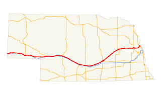
U.S. Highway 30 (US 30) is part of the United States Numbered Highway System that runs for 3,073 miles (4,946 km) from Astoria, Oregon to Atlantic City, New Jersey. Within the state of Nebraska it is a state highway that travels 451.74 miles (727.01 km) west to east across the state from the Wyoming state line west of Bushnell to the Missouri River in Blair on the Iowa state line. For much of its length it travels within the Platte River valley, adjacent or near the river between Brule and Fremont, a distance of just over 300 miles (480 km). This corridor was also highly traveled during Westward Expansion along the California and Oregon Trails, it was also used by the Pony Express and the Transcontinental Railroad. The landscape is dominated by vast agricultural fields within the fertile Platte River valley across the center of the state, while the western portion passes through higher plains and the eastern portion through the rolling hills adjacent to the Missouri River valley.

The Dinosaur Diamond Scenic Byway is a 512-mile-long (824 km) National Scenic Byway in the U.S. states of Utah and Colorado. The highway forms a diamond-shaped loop with vertices at Moab, Helper, Vernal and Grand Junction.
Idaho State Highway 200 (SH-200) is a two-lane highway from Ponderay, Idaho eastward to the Montana border. The highway has been dedicated as a national scenic byway and given the name Pend Oreille Scenic Byway.

State Highway 75 is a two-lane highway that travels through the Sawtooth Valley of central Idaho. The highway's southern terminus is in Shoshone, and its northern is near Challis. It is designated as one of Idaho's scenic byways and provides access to Sawtooth National Recreation Area. It primarily follows the Big Wood River in the south and the main Salmon River in the north, divided by Galena Summit.
U.S. Highway 75 is a part of the United States Numbered Highway System that runs for 1,239 miles (1,994 km) from Dallas, Texas to Kittson County, Minnesota where it ends just short of the Canada–United States border. Within the State of Nebraska it is a state highway that enters Nebraska on the Kansas state line about 9 miles (14 km) south of Dawson and travels north across the extreme eastern portion of the state, to the Nebraska–Iowa border in South Sioux City where it crosses the Missouri River along a concurrency with Interstate 129. The northern 210 miles (340 km) of the route generally travels parallel to the Missouri River. The 87.32-mile (140.53 km) section between the I-680 interchange in Omaha and the Interstate 129 interchange is designated the Lewis & Clark Scenic Byway, one of nine scenic byways in the state.

State Highway 1 is a state highway in Boundary County, in the U.S. state of Idaho. It extends 11.185 miles (18.00 km) from U.S. Route 95 (US-95) east of Copeland, north to British Columbia Highway 21 (BC 21) in Porthill. The route serves as a connector between Bonners Ferry, via US-95 south, Porthill, and Creston, BC. The highway is one of two border crossings from Idaho into British Columbia. The other crossing is at the US-95/BC 95 in Eastport. The highway is also known for being the only state highway in Boundary County, the two other highways are US-95 and US-2. The highway is also part of the International Selkirk Loop, the only international scenic byway in North America.
In Tennessee, U.S. Route 64 stretches from the Mississippi River in Memphis to the North Carolina state line near Ducktown. The highway, along with US 72, is a major route for travel between Memphis and Chattanooga.
Wyoming Highway 239 is a 1.64-mile-long (2.64 km) state road that in Lincoln County, Wyoming connects U.S. Route 89 and Idaho State Highway 34 at the Idaho state line.
Monticello Crossroads Scenic Byway is a 29.0-mile-long (46.7 km) scenic route located in the central part of the U.S. state of Georgia. It travels through pine forests and hilly agricultural land in Jasper County. It includes sections of State Route 11 (SR 11) and SR 83 north from Monticello. The routes were used by Native Americans and evangelist Methodist circuit riders. The byway passes through the Monticello Historic District and travels past several buildings on the National Register of Historic Places.
State Highway 97 (SH-97) is a state highway in Kootenai County, Idaho. The highway runs for 35.745 miles (57.526 km) from State Highway 3 to Interstate 90 (I-90) along the east side of Lake Coeur d'Alene, passing through the community of Harrison. The entire highway is designated as the Lake Coeur d'Alene Scenic Byway.
State Highway 77 (SH-77) is a state highway in Cassia County, Idaho. The highway runs for 33.978 miles (54.682 km) from SH-81 in Malta to Interstate 84 north of Declo, serving the town of Albion.


