Iliamna, Alaska

Last updated

Iliamna, Alaska
Illiamna
AKMap-doton-Newhalen.PNG
Location of Iliamna, Alaska
Coordinates: 59°45′54″N154°50′25″W / 59.76500°N 154.84028°W / 59.76500; -154.84028
Country United States
State Alaska
Borough Lake and Peninsula
Government
  Borough mayor Glen Alsworth, Sr. [1]
   State senator Lyman Hoffman (D) [2]
   State rep. Bryce Edgmon (I)
Area
[3]
  Total37.69 sq mi (97.61 km2)
  Land37.22 sq mi (96.39 km2)
  Water0.47 sq mi (1.21 km2)
Elevation
155 ft (47 m)
Population
 (2020)
  Total108
  Density2.90/sq mi (1.12/km2)
Time zone UTC-9 (Alaska (AKST))
  Summer (DST) UTC-8 (AKDT)
ZIP codes
99606, 99647
Area code 907
FIPS code 02-35120

Iliamna (Dena'ina: Illiamna) is a census-designated place (CDP) in Lake and Peninsula Borough, Alaska, United States. The population was 108 at the 2020 census, [4] slightly down from 109 in 2010. [5]

Contents

History

Iliamna Landing Field, 1942 Landing Fields - Alaska - Illiamna - NARA - 68158848 (cropped).jpg
Iliamna Landing Field, 1942

Iliamna was originally the name of an Athabaskan village at the point where the Iliamna River flows into Iliamna Lake, about 40 miles (64 km) east of present-day Iliamna. That site is now called Old Iliamna (Dena'inaNuch'ak'dalitnu’). In 1935, the residents of Old Iliamna moved to the present-day location. [6]

The first sport fishing lodge in Iliamna was built in the 1930s, and the second was built in the 1950s. Many more were built later in the 20th century. Iliamna's economy has two main elements: subsistence fishing and hunting and sport fishing lodges. Year-round residents largely pursue subsistence activities, while summer workers from other areas work in the lodges.

Around 1913, Herman Gartelmann, Jack Kinney, and Ed Ahola built a roadhouse here, taking advantage of air travel through Lake Clark Pass. Jack and Ed were from Old Iliamna village. Frederick Roehl purchased the roadhouse around 1917, and when he died in 1923, Hans Seversen took over and the facility became known as Seversen's Roadhouse. He started hosting big game hunters in 1921 and the first sport fishermen in 1937. Martin Seversen ran the operation from 1946 and put up a new building. Mary Seversen Clark sold the operation in 1956. [7]

Iliamna faces the prospect of developing into a mining town, as several multi-national companies plan to develop the area northwest of the village into one of North America's largest gold-copper-molybdenum mines. The first company to submit plans to the State of Alaska is Northern Dynasty Minerals, a wholly owned subsidiary of Hunter Dickinson. The Lake and Peninsula Borough, the region's governing body, passed a strong resolution in support of the mine's development, but the majority of the surrounding villages adamantly oppose it. Two non-profit organizations are leading the fight against open-pit mining in the Bristol Bay watershed - the Bristol Bay Alliance and the Renewable Resources Coalition. A study concluded in 2006 indicated the majority of Alaskans were opposed to the development.[ citation needed ]

Geography

Iliamna is located in southwest Alaska at 59°45′54″N154°50′25″W / 59.76500°N 154.84028°W / 59.76500; -154.84028 (59.765135, -154.840312). [8] It is bordered to the south by the city of Newhalen, to the west by the Newhalen River, and to the southeast by Iliamna Lake.

According to the United States Census Bureau, the CDP has a total area of 37.6 square miles (97.4 km2), of which 37.1 square miles (96.2 km2) are land and 0.46 square miles (1.2 km2), or 1.23%, are water. [5]

Climate

Climate chart for Iliamna Monthly Climate Normals (1991-2020) - ILIAMNA AIRPORT, AK.svg
Climate chart for Iliamna

Iliamna has a continental subarctic climate (Köppen Dfc) with mild summers and severely cold winters. Iliamna's year-round average temperature is 37.7 °F (3.2 °C), with five months averaging below freezing (32 °F (0 °C)) and three months averaging above 50 °F (10 °C), July is the warmest month with an average temperature of 57.8 °F (14.3 °C) and January is the coldest month with an average temperature of 18.4 °F (−7.6 °C). [9] Winters are sometimes very cold, and in some years there are even low temperatures below −40 °F (−40 °C), usually 32 days have a minimum 0 °F (−18 °C) or below annually, and the coldest temperature in a year can drop to −21 °F (−29 °C), so Iliamna falls in USDA Plant Hardiness Zones 4b. [10] The coldest day of the year averaged −11 °F (−24 °C) in the 1991 to 2020 normals, while the warmest night average was at 57 °F (14 °C). The coldest daytime maximum on record is −33 °F (−36 °C) on January 19, 1947, while, conversely, the record warm daily minimum is 61 °F (16 °C) on August 13, 2019. [11] Extreme temperatures have ranged from −47 °F (−44 °C) on January 22, 1947, up to 91 °F (33 °C) on June 27, 1953. [11] The coldest month has been January 1947 and December 1942 with a mean temperature of −6.5 °F (−21.4 °C), while the warmest month was July 2019 at 63.2 °F (17.3 °C); the annual mean temperature has ranged from 28.2 °F (−2.1 °C) in 1956 to 42.1 °F (5.6 °C) in 2019. [11]

Iliamna receives 25.01 inches (635 mm) of annual precipitation, mostly between summer and fall. [9] September 1961 was the wettest month, with 11.02 inches (280 mm) of precipitation, and there were many months without recorded precipitation. The wettest year was 1985 with 40.79 inches (1,036 mm) of precipitation, while the driest was 1968 with 15.33 inches (389 mm). [11]

Climate data for Iliamna Airport, Alaska (1991–2020 normals, extremes 1920–present [lower-alpha 1] )
MonthJanFebMarAprMayJunJulAugSepOctNovDecYear
Record high °F (°C)57
(14)
49
(9)
52
(11)
67
(19)
80
(27)
91
(33)
86
(30)
83
(28)
75
(24)
66
(19)
52
(11)
49
(9)
91
(33)
Mean maximum °F (°C)42.4
(5.8)
42.6
(5.9)
43.5
(6.4)
54.2
(12.3)
67.6
(19.8)
74.3
(23.5)
76.8
(24.9)
73.4
(23.0)
64.1
(17.8)
54.4
(12.4)
45.7
(7.6)
43.2
(6.2)
78.8
(26.0)
Mean daily maximum °F (°C)24.8
(−4.0)
29.9
(−1.2)
31.7
(−0.2)
43.3
(6.3)
54.7
(12.6)
62.0
(16.7)
64.9
(18.3)
63.5
(17.5)
56.0
(13.3)
44.6
(7.0)
33.2
(0.7)
28.0
(−2.2)
44.7
(7.1)
Daily mean °F (°C)18.4
(−7.6)
23.1
(−4.9)
23.7
(−4.6)
36.1
(2.3)
46.3
(7.9)
53.7
(12.1)
57.8
(14.3)
56.7
(13.7)
49.7
(9.8)
38.4
(3.6)
27.1
(−2.7)
21.7
(−5.7)
37.7
(3.2)
Mean daily minimum °F (°C)11.9
(−11.2)
16.3
(−8.7)
15.7
(−9.1)
28.8
(−1.8)
37.9
(3.3)
45.4
(7.4)
50.7
(10.4)
49.9
(9.9)
43.3
(6.3)
32.3
(0.2)
21.0
(−6.1)
15.3
(−9.3)
30.7
(−0.7)
Mean minimum °F (°C)−16.9
(−27.2)
−11.0
(−23.9)
−6.7
(−21.5)
10.1
(−12.2)
28.3
(−2.1)
36.4
(2.4)
43.4
(6.3)
39.8
(4.3)
30.6
(−0.8)
16.0
(−8.9)
−0.6
(−18.1)
−9.6
(−23.1)
−21.0
(−29.4)
Record low °F (°C)−47
(−44)
−46
(−43)
−30
(−34)
−30
(−34)
4
(−16)
28
(−2)
30
(−1)
22
(−6)
20
(−7)
−4
(−20)
−20
(−29)
−31
(−35)
−47
(−44)
Average precipitation inches (mm)0.90
(23)
1.06
(27)
0.84
(21)
0.83
(21)
1.19
(30)
1.51
(38)
3.08
(78)
4.14
(105)
5.01
(127)
2.84
(72)
2.16
(55)
1.45
(37)
25.01
(635)
Average snowfall inches (cm)12.0
(30)
9.5
(24)
10.0
(25)
5.4
(14)
1.0
(2.5)
0.0
(0.0)
0.0
(0.0)
0.0
(0.0)
0.0
(0.0)
2.3
(5.8)
8.2
(21)
12.7
(32)
61.1
(155)
Average precipitation days (≥ 0.01 in)7.78.77.58.08.99.513.515.916.213.311.810.7131.6
Average snowy days (≥ 0.1 in)7.06.66.84.60.80.00.00.00.01.65.27.940.5
Average dew point °F (°C)10.0
(−12.2)
16.8
(−8.4)
13.3
(−10.4)
25.1
(−3.8)
33.7
(0.9)
42.3
(5.7)
48.6
(9.2)
48.3
(9.1)
40.9
(4.9)
29.9
(−1.2)
18.4
(−7.6)
13.4
(−10.3)
28.4
(−2.0)
Source 1: NOAA / National Weather Service (average snowfall/snow days 19201997) [9] [11]
Source 2: Western Regional Climate Center (dew point 1998–2011) [12]

Note

  1. Temperatures have been recorded at Iliamna Airport since April 1920, with there being periods of no recording during March 1923-March 1941 and December 1973-June 1975.

Demographics

Historical population
CensusPop.Note
1940 30
1950 4446.7%
1960 476.8%
1970 5823.4%
1980 9462.1%
1990 940.0%
2000 1028.5%
2010 1096.9%
2020 108−0.9%
U.S. Decennial Census [13]

The current Iliamna first appeared on the 1940 U.S. Census as an unincorporated village. It was made a census-designated place (CDP) in 1980. Prior to 1940, the Iliamna listed on the census was for the former village of (Old) Iliamna, located on the east side of the lake, which is no longer in existence. [14]

As of the census [15] of 2000, there were 102 people, 35 households, and 26 families residing in the CDP. The population density was 2.8 inhabitants per square mile (1.1/km2). There were 58 housing units at an average density of 1.6 per square mile (0.62/km2). The racial makeup of the CDP was 39.22% White, 50.00% Native American, and 10.78% from two or more races.

There were 35 households, out of which 45.7% had children under the age of 18 living with them, 62.9% were married couples living together, 5.7% had a female householder with no husband present, and 25.7% were non-families. 20.0% of all households were made up of individuals, and 2.9% had someone living alone who was 65 years of age or older. The average household size was 2.91 and the average family size was 3.42.

In the CDP, the population was spread out, with 34.3% under the age of 18, 6.9% from 18 to 24, 28.4% from 25 to 44, 28.4% from 45 to 64, and 2.0% who were 65 years of age or older. The median age was 32 years. For every 100 females, there were 112.5 males. For every 100 females age 18 and over, there were 103.0 males.

The median income for a household in the CDP was $60,625, and the median income for a family was $61,250. Males had a median income of $38,333 versus $36,667 for females. The per capita income for the CDP was $19,741. There were no families and 3.1% of the population living below the poverty line, including no under eighteens and none of those over 64.

Related Research Articles

<span class="mw-page-title-main">Akiachak, Alaska</span> Census-designated place in Alaska, United States

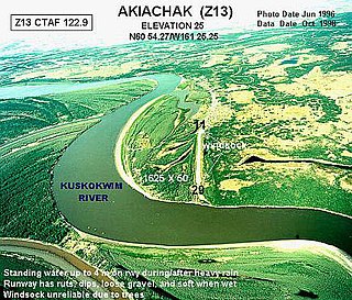
Akiachak is a census-designated place (CDP) in the Bethel Census Area in the U.S. state of Alaska. The population was 677 in the 2020 census, up from 627 in 2010, and 585 in 2000.

<span class="mw-page-title-main">Stony River, Alaska</span> Census-designated place in Alaska, United States

Stony River is a census-designated place (CDP) in Bethel Census Area, Alaska, United States. The population was 54 at the 2010 census, down from 61 in 2000.

<span class="mw-page-title-main">King Salmon, Alaska</span> Census-designated place in Alaska

King Salmon is a census-designated place (CDP) in Bristol Bay Borough in the U.S. state of Alaska. It is 284 miles (457 km) southwest of Anchorage. As of the 2020 census the population was 307, down from 374 in 2010. It is home to Katmai National Park and Preserve. King Salmon is the borough seat of neighboring Lake and Peninsula Borough, but does not serve that purpose in its own borough, whose borough seat is in Naknek.

<span class="mw-page-title-main">Kalifornsky, Alaska</span> Census-designated place in Alaska, United States

Kalifornsky is a census-designated place (CDP) in Kenai Peninsula Borough, Alaska, United States. The population was 8,487 at the 2020 census, up from 7,850 in 2010. It is the most populated locality in the borough.

<span class="mw-page-title-main">Nanwalek, Alaska</span> Census-designated place in Alaska, United States

Nanwalek, formerly Alexandrovsk and later English Bay, is a census-designated place (CDP) in the Kenai Peninsula Borough, Alaska, United States, that contains a traditional Alutiiq village. The population was 254 at the 2010 census, up from 177 in 2000. There is one school located in the community, attended by 76 students.

Aleneva is a census-designated place in the Kodiak Island Borough in the U.S. state of Alaska. As of the 2010 census, the population was 37, down from 68 in 2000.

Kokhanok is a census-designated place (CDP) in Lake and Peninsula Borough, Alaska, United States. At the 2020 census the population was 152, down from 170 in 2000.

Newhalen is a city in Lake and Peninsula Borough, Alaska, United States. At the 2020 census, the population was 168.

<span class="mw-page-title-main">Nondalton, Alaska</span> Town in Alaska, United States

Nondalton is a town on the west shore of Six Mile Lake in the Lake and Peninsula Borough, Alaska, United States. At the 2020 census, the population was 133, down from 164 in 2010.

<span class="mw-page-title-main">Pedro Bay, Alaska</span> Census-designated place in Alaska, United States

Pedro Bay is a census-designated place (CDP) in Lake and Peninsula Borough, Alaska, United States. The population was 43 as of the 2020 census, slightly up from 42 in 2010.

<span class="mw-page-title-main">Port Alsworth, Alaska</span> Census-designated place in Alaska, United States

Port Alsworth is a census-designated place (CDP) in Lake and Peninsula Borough, Alaska, United States. It is 165 miles (266 km) by air southwest of Anchorage. The population was 186 at the 2020 census, up from 159 in 2010. It is the most populated community in the borough.

<span class="mw-page-title-main">Knik River, Alaska</span> CDP in Alaska, United States

Knik River is a census-designated place (CDP) in Matanuska-Susitna Borough in the U.S. state of Alaska. Located 15 miles southeast from Palmer along the Knik River, it is part of the Anchorage, Alaska Metropolitan Statistical Area. The population was 792 at the 2020 census, up from 744 in 2010.

<span class="mw-page-title-main">Susitna North, Alaska</span> CDP in Alaska, United States

Susitna North is a census-designated place (CDP) in the Matanuska-Susitna Borough in the U.S. state of Alaska. It is part of the Anchorage, Alaska Metropolitan Statistical Area. The population was 1,564 at the 2020 census, up from 1,260 in 2010. The CDP was formerly named Y, for the intersection of the George Parks Highway and the Talkeetna Spur Road. In the immediate vicinity of this intersection is a community center, containing a health clinic, law enforcement, Susitna Valley High School, and retail services for highway travelers such as gasoline and food.

<span class="mw-page-title-main">Metlakatla, Alaska</span> CDP in Alaska, United States

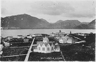
Metlakatla is a census-designated place (CDP) on Annette Island in Prince of Wales-Hyder Census Area, Alaska, United States. At the 2010 census the population was 1,405; this had grown to 1,454 by the 2020 census.

<span class="mw-page-title-main">Slana, Alaska</span> CDP in Alaska, United States

Slana is a census-designated place (CDP) in the Copper River Census Area in the Unorganized Borough of the U.S. state of Alaska. As of the 2020 census, the population of the CDP was 116, down from 147 in 2010.

<span class="mw-page-title-main">Allakaket, Alaska</span> City in Alaska, United States

Allakaket is a second class city in the Yukon-Koyukuk Census Area of the Unorganized Borough of the U.S. state of Alaska. The population was 105 at the 2010 census.

<span class="mw-page-title-main">Evansville, Alaska</span> CDP in Alaska, United States

Evansville is a census-designated place (CDP) in Yukon-Koyukuk Census Area, Alaska, United States. The population was 15 at the 2010 census, down from 28 in 2000. The community is adjacent to Bettles. The community is named after Wilford Evans, Sr, who took part in the founding of Bettles Lodge.

<span class="mw-page-title-main">Price Township, Pennsylvania</span> Place in Pennsylvania, United States

Price Township is a township in Monroe County, Pennsylvania, United States. The population was 3,675 at the 2020 census.

<span class="mw-page-title-main">Lesslie, South Carolina</span> CDP in South Carolina, United States

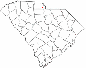
Lesslie is a census-designated place located in York County, South Carolina, United States, southeast of the city of Rock Hill. In 2010, Lesslie had a total population of 2,882 people.

<span class="mw-page-title-main">Lake Clark National Park and Preserve</span> National park in southwest Alaska, United States

Lake Clark National Park and Preserve is an American national park in southwest Alaska, about 100 miles (160 km) southwest of Anchorage. The park was first proclaimed a national monument in 1978, then established as a national park and preserve in 1980 by the Alaska National Interest Lands Conservation Act. The park includes many streams and lakes vital to the Bristol Bay salmon fishery, including its namesake Lake Clark. A wide variety of recreational activities may be pursued in the park and preserve year-round. The park protects rainforests along the coastline of Cook Inlet, alpine tundra, glaciers, glacial lakes, major salmon-bearing rivers, and two volcanoes, Mount Redoubt and Mount Iliamna. Mount Redoubt is active, erupting in 1989 and 2009. The wide variety of ecosystems in the park mean that virtually all major Alaskan animals, terrestrial and marine, may be seen in and around the park. Salmon, particularly sockeye salmon, play a major role in the ecosystem and the local economy. Large populations of brown bears are attracted to feed on the spawning salmon in the Kijik River and at Silver Salmon Creek. Bear watching is a common activity in the park.

References

  1. 2015 Alaska Municipal Officials Directory. Juneau: Alaska Municipal League. 2015. p. 12.
  2. "Senator Lyman Hoffman". Alaska Senate Majority. Alaskasenate.org. Archived from the original on April 8, 2020. Retrieved November 16, 2019.
  3. "2020 U.S. Gazetteer Files". United States Census Bureau. Retrieved October 29, 2021.
  4. "2020 Census Data - Cities and Census Designated Places" (Web). State of Alaska, Department of Labor and Workforce Development. Retrieved December 5, 2021.
  5. 1 2 "Geographic Identifiers: 2010 Census Summary File 1 (G001), Iliamna CDP, Alaska". American FactFinder. U.S. Census Bureau. Archived from the original on February 13, 2020. Retrieved August 14, 2019.
  6. "Native Village of Iliamna". Lake and Peninsula Borough, Alaska . Retrieved February 5, 2017.
  7. Bennett, Bo (2000). Rods & Wings. Anchorage: Publication Consultants. pp. 62–63. ISBN   9781888125627.
  8. "US Gazetteer files: 2010, 2000, and 1990". United States Census Bureau. February 12, 2011. Retrieved April 23, 2011.
  9. 1 2 3 "U.S. Climate Normals Quick Access". National Oceanic and Atmospheric Administration. Archived from the original on May 7, 2023. Retrieved September 12, 2022.
  10. "USDA Plant Hardiness Zone Map". Agricultural Research Center, PRISM Climate Group Oregon State University. Archived from the original on February 27, 2014. Retrieved November 1, 2019. Input 99603 in the ZIP Code box.
  11. 1 2 3 4 5 "NOAA Online Weather Data". National Weather Service. Retrieved September 12, 2022.
  12. "AVERAGE MONTHLY DEW POINT TEMPERATURE (F)". WRCC. Archived from the original on July 29, 2023. Retrieved July 29, 2023.
  13. "U.S. Decennial Census". Census.gov. Retrieved June 6, 2013.
  14. "Geological Survey Professional Paper". 1949.
  15. "U.S. Census website". United States Census Bureau . Retrieved January 31, 2008.