Survey Education
Introduction of innovative surveying systems such as the Global Positioning System, Electronic Distance Measurement, digital levels and theodolites, Laser scanners, digital sensors, high resolution satellite imageries etc., has revolutionised the scope of spatial data collection. However, on account of deficiencies in our system of Survey Education and practices, many of these technologies have yet to acquire the status of enabling technology in India.
Broadly, the ethos can be attributed to two main reasons - the Survey Education, by itself, being not popular as a discipline of science and there being no regularatory standards to control the practices of collecting spatial data. A lot of spatial data being generated by various institutions using high-end technology by untrained manpower, being inconsistent in accuracies and unrelated to any meta-data standards on account of lack of professional supervision, cannot be put to universal use in a multi-disciplinary environment.
Such efforts, although meeting a limited requirement, do not contribute to the national need of a standardised spatial data base and are often found wanting in accuracy when integrated with a regional or national perspective. For deriving full benefits and optimising the use of resources, knowledge of the fundamentals of land surveying and various methodologies of interfacing them with the new technologies has, therefore, become an inescapable requirement for all technologists and planners engaged in generation and manipulation of spatial information.
Survey Education deals with the concepts and methodologies of gathering, processing and representing geo-spatial data in a defined form and format. It encompasses education on theories and practices in disciplines of geodesy, geo-physics, photogrammetry, land surveying, cartography and reprography. With the introduction of computers and change of emphasis from analogue to digital technology and high expectations from GIS, computer sciences and various systems for generation of spatial data bases have become an integral part of survey education.
To keep pace with the present day requirement of spatial data, education on the modern tools of data gathering such as GPS, Digital Photogrammetry, laser ranging, remote sensing etc., and associated technologies in visualization of spatial data, has acquired a special place in Survey Education. Despite the sophistication in technology, need-based emphasis on accuracies, reliability and consistency in data generation remain the cardinal principle in Survey Education.
Additional Surveyor General: P. V. Srinivas
Deputy Surveyor General (Tech): S. K. Sinha
Deputy Surveyor General (Adm): Col. Sareen Chander

A geographic information system (GIS) consists of integrated computer hardware and software that store, manage, analyze, edit, output, and visualize geographic data. Much of this often happens within a spatial database, however, this is not essential to meet the definition of a GIS. In a broader sense, one may consider such a system also to include human users and support staff, procedures and workflows, the body of knowledge of relevant concepts and methods, and institutional organizations.

A digital elevation model (DEM) or digital surface model (DSM) is a 3D computer graphics representation of elevation data to represent terrain or overlaying objects, commonly of a planet, moon, or asteroid. A "global DEM" refers to a discrete global grid. DEMs are used often in geographic information systems (GIS), and are the most common basis for digitally produced relief maps. A digital terrain model (DTM) represents specifically the ground surface while DEM and DSM may represent tree top canopy or building roofs.

Topography is the study of the forms and features of land surfaces. The topography of an area may refer to the land forms and features themselves, or a description or depiction in maps.

Geomatics is defined in the ISO/TC 211 series of standards as the "discipline concerned with the collection, distribution, storage, analysis, processing, presentation of geographic data or geographic information". Under another definition, it consists of products, services and tools involved in the collection, integration and management of geographic (geospatial) data. Surveying engineering was the widely used name for geomatic(s) engineering in the past. Geomatics was placed by the UNESCO Encyclopedia of Life Support Systems under the branch of technical geography.

Photogrammetry is the science and technology of obtaining reliable information about physical objects and the environment through the process of recording, measuring and interpreting photographic images and patterns of electromagnetic radiant imagery and other phenomena.

Geoinformatics is a scientific field primarily within the domains of Computer Science and technical geography. It focuses on the programming of applications, spatial data structures, and the analysis of objects and space-time phenomena related to the surface and underneath of Earth and other celestial bodies. The field develops software and web services to model and analyse spatial data, serving the needs of geosciences and related scientific and engineering disciplines. The term is often used interchangeably with Geomatics, although the two have distinct focuses; Geomatics emphasizes acquiring spatial knowledge and leveraging information systems, not their development. At least one publication has claimed the discipline is pure computer science outside the realm of geography.
Ordnance Survey of Northern Ireland (OSNI) is the official mapping agency of Northern Ireland. The agency ceased to exist separately on 1 April 2008 when it became part of Land and Property Services, an executive agency of the Northern Ireland Department of Finance and Personnel, along with the Rate Collection Agency, the Valuation and Lands Agency, and the Land Registry.

The Survey of India is India's central engineering agency in charge of mapping and surveying. Set up in 1767 to help consolidate the territories of the British East India Company, it is one of the oldest Engineering Departments of the Government of India. Its members are from Survey of India Service cadre of Civil Services of India. It is headed by the Surveyor General of India. At present, the Surveyor General is Hitesh Kumar S. Makwana.
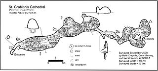
A cave survey is a map of all or part of a cave system, which may be produced to meet differing standards of accuracy depending on the cave conditions and equipment available underground. Cave surveying and cartography, i.e. the creation of an accurate, detailed map, is one of the most common technical activities undertaken within a cave and is a fundamental part of speleology. Surveys can be used to compare caves to each other by length, depth and volume, may reveal clues on speleogenesis, provide a spatial reference for other areas of scientific study and assist visitors with route-finding.
The Indian Institute of Remote Sensing is an institute for research, higher education and training in the field of remote sensing, geoinformatics and GPS technology for natural resources, environmental and disaster management. The institute was established in the year 1966 under the Indian Department of Space. It is located in the city of Dehradun, Uttarakhand.
The American Society for Photogrammetry and Remote Sensing (ASPRS) is an American learned society devoted to photogrammetry and remote sensing. It is the United States' member organization of the International Society for Photogrammetry and Remote Sensing. Founded in 1934 as American Society of Photogrammetry and renamed in 1985, the ASPRS is a scientific association serving over 7,000 professional members around the world. As a professional body with oversight of specialists in the arts of imagery exploitation and photographic cartography. Its official journal is Photogrammetric Engineering & Remote Sensing (PE&RS), known as Photogrammetric Engineering between 1937 and 1975.

A national mapping agency is an organisation, usually publicly owned, that produces topographic maps and geographic information of a country. Some national mapping agencies also deal with cadastral matters.

The UNSW School of Surveying and Geospatial Engineering (SAGE), part of the UNSW Faculty of Engineering, was founded in 1970 and disestablished in 2013.

The Ethiopian Mapping Agency (EMA) is an Ethiopian government agency, a department within the Ministry of Finance and Cooperation, that is responsible for cartographic mapping and remote sensing activities in Ethiopia. The EMA has expanded its operation to include a comprehensive map revision program in addition to various phases of digital mapping and information technology.
Prof. em. Dr. Armin Gruen is, since 1984, professor and head of the Chair of photogrammetry at the Institute of Geodesy and Photogrammetry (IGP), Federal Institute of Technology (ETH) Zurich, Switzerland. Since 1 August 2009, he is retired and is now with the Chair of Information Architecture, ETH Zurich Faculty of Architecture. He is currently acting as a principal investigator on the Simulation Platform of the SEC-FCL in Singapore.

Mobile mapping is the process of collecting geospatial data from a mobile vehicle, typically fitted with a range of GNSS, photographic, radar, laser, LiDAR or any number of remote sensing systems. Such systems are composed of an integrated array of time synchronised navigation sensors and imaging sensors mounted on a mobile platform. The primary output from such systems include GIS data, digital maps, and georeferenced images and video.
Survey of Pakistan is the sole national mapping and land surveying government agency of Pakistan. Its head of department is titles as "Surveyor General of Pakistan".

The Surveying and Spatial Sciences Institute (SSSI) is the professional association for surveyors and spatial science workers, including cartography, hydrography, remote sensing, engineering and mining surveying, photogrammetry and spatial information in Australia. The Institute's members are involved in communities of practice such as land administration, land development, natural resource management, forestry, agriculture, defence, marine environment, local government, health, education, transport, tourism, and many more. The institute deals with policy, administration, collection, measurement, analysis, interpretation, portrayal and dissemination of spatially- related land and sea information, together with associated planning, design and management.
The Journal of Spatial Science is an academic journal about spatial sciences published by Taylor & Francis on behalf of the Mapping Sciences Institute (Australia) and the Surveying and Spatial Sciences Institute. It covers cartography, geodesy, geographic information science, hydrography, digital image analysis and photogrammetry, remote sensing, surveying and related areas. Its editor-in-chief is Graeme Wright; its 2018 impact factor is 1.711.
Geological structure measurement by LiDAR technology is a remote sensing method applied in structural geology. It enables monitoring and characterisation of rock bodies. This method's typical use is to acquire high resolution structural and deformational data for identifying geological hazards risk, such as assessing rockfall risks or studying pre-earthquake deformation signs.