
Maryland Route 55 (MD 55) is a state highway in the U.S. state of Maryland. Known as Vale Summit Road, the state highway runs 2.53 miles (4.07 km) from MD 36 in Vale Summit north to U.S. Route 40 Alternate in Clarysville. MD 55 connects the La Vale area with Midland in the upper Georges Creek Valley in northwestern Allegany County. MD 55 was paved from Clarysville to Vale Summit around 1921 and extended south to Midland in the late 1930s. The southern terminus of the state highway was truncated at Vale Summit when MD 36 took over part of the highway for a new alignment in the early 1970s.
Clarysville is an unincorporated community and census-designated place (CDP) in Allegany County, Maryland, United States. As of the 2010 census it had a population of 73.

The Casselman Bridge is an historic transportation structure on the Casselman River, located immediately east of Grantsville in Garrett County, Maryland. The bridge was built in 1813-1814 as part of the National Road. Historic markers posted at each end read:
Erected 1813 by David Shriver, Jr.,
Sup't of the "Cumberland Road". This 80 foot span
was the largest stone arch in America
at the time. It was continuously
used from 1813 to 1933.
The Breakneck Road Historic District is a rural agricultural landscape near Flintstone, Allegany County, Maryland. The farms and their associated lands have remained in the possession of a small number of families since the time of their settlement.
U.S. Route 40 Alternate is the U.S. Highway designation for a former segment of U.S. Route 40 (US 40) through Garrett and Allegany counties in Maryland. The highway begins at US 40 near exit 14 on Interstate 68 (I-68) and runs 31.80 miles (51.18 km) eastward to Cumberland, where it ends at exit 44 on I-68. Alt US 40 is maintained by the Maryland State Highway Administration (MDSHA).

16 Altamont Terrace is a historic home in Cumberland, Allegany County, Maryland, United States. Built circa 1851, it is an example of Greek Revival architecture, with an Ionic portico above a stone foundation and cast iron balconies. The house served as the Allegany County hospital from 1889 to 1890. The building was converted into apartments in about 1905.
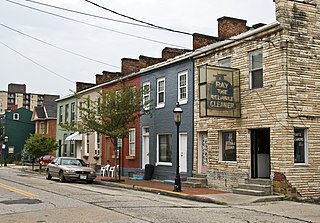
200, 202, 204, 206 and 208 Decatur Street are adjoining rowhouses in Cumberland, Allegany County, Maryland. The houses were built in the 1840s or early 1850s. The houses are of a type that, while common elsewhere in Maryland, were not extensively built in Cumberland, in which individual and semi-detached houses were more common. The houses exhibit plain but consistent detailing of a neoclassical nature.

The "Old National Pike Milestones" marked each mile of the old National Road in Maryland, an eastern coastal state of the United States, from its dominating city of Baltimore to major towns of western Maryland, as Frederick, and between it and Hagerstown, to Hancock, through to Cumberland in the western panhandle of the state in the foothills of the Appalachian Mountains. The surviving stones have been included in the "National Register of Historic Places", maintained by the National Park Service of the U.S. Department of the Interior, and may be seen along the route variously designated as U.S. Route 40, Maryland Route 144, Alternate U.S. Route 40, and several other roads that trace the path of the original "Old National Pike". From Baltimore to Cumberland, the road was surveyed and laid out with construction in several phases over different periods of time by several turnpike companies, chartered by the General Assembly of Maryland beginning in 1808. Earlier in 1806, the United States Congress with the approval of third President Thomas Jefferson, authorized the surveying and further construction of a "national road" to continue on from Cumberland on the upstream of the Potomac River further to the west across additional mountainous ranges in the Allegheny Mountains to the newly admitted State of Ohio. Later the congressional action was amended to direct the road to the state boundaries on the Ohio River and it eventually landed at Wheeling, West Virginia. In later decades, the road was extended west across Ohio, Indiana and into the Illinois Country, to eventually terminate by the 1840s in Vandalia, the territorial capital of Illinois, just east of the Mississippi River, and northeast of the newly emergent, frontier river port metropolis of St. Louis of the Missouri Territory and the former Louisiana Purchase of 1803 to the west.

The Francis Haley House is a historic home in Cumberland, Allegany County, Maryland, United States. The house is an Italianate-influenced 2+1⁄2-story, brick structure built about 1870. It was erected as the residence of a brick manufacturer, Francis Haley.

Thomas Koon House is a historic home in Cumberland, Allegany County, Maryland, United States. It is a brick Prairie-style house of large scale built in about 1912. It features arranged rectangular blocks with large expanses of window space, a terra cotta tiled hip roof and a small similarly influenced detached garage. The house was designed by Holmboe & Lafferty of Clarksburg for Doctor Thomas W. Koon, who arrived in Cumberland setting up an "active general practice" in May 1900.
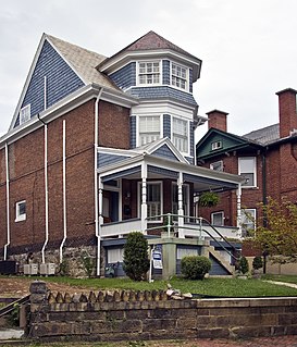
Wright Butler House is a historic home in Cumberland, Allegany County, Maryland, United States. It is a 2+1⁄2-story, Queen Anne-style suburban one-unit dwelling built about 1896. The house was the home of Wright Butler (1868–1932), one of Cumberland's leading architects at the turn of the 20th century. He also designed the George Truog House.
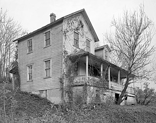
Phoenix Mill Farm, historically known as Mill Run Farm, is a historic home located in Dickens, Allegany County, Maryland, United States. It is a 2+1⁄2-story Flemish bond brick structure showing Greek Revival style influences built about 1845. It has a gable roof and double flush chimneys. On the property is the site of Smouse Mill. The home was erected for John Jacob Smouse, who operated the mill.

Western Maryland Railroad Right-of-Way, Milepost 126 to Milepost 160 is a historic section of the Western Maryland Railway (WM) in Allegany County, Maryland, and Morgan County, West Virginia. It is an abandoned 34-mile (55 km) section of the right-of-way between milepost 126 at the intersection of the Chesapeake and Ohio (C&O) Canal and Long Ridge Road, Woodmont, and milepost 160 just west of Maryland Route 51, North Branch. It closely parallels the Potomac River and the C&O Canal, which runs along the north bank of the river, and includes three tunnels. Seven miles of the roadbed are in West Virginia near Paw Paw.
The Frostburg Historic District is a national historic district in Frostburg, Allegany County, Maryland. It comprises 356 resources within the city of Frostburg, along U.S. Route 40, which forms the main axis of the district. Included are a collection of early-20th century commercial buildings, primarily of brick construction, two or three stories tall, and a collection of mid- to late-19th and early-20th century homes reflecting a variety of architectural styles, including Italianate, Second Empire, Queen Anne, and Colonial Revival.

The Washington Street Historic District is a national historic district named after George Washington in Cumberland, Allegany County, Maryland. It is an approximately 35-acre (140,000 m2) residential area to the west of downtown Cumberland and consists primarily of six blocks of Washington Street. It contains large-scale 19th- and 20th-century houses representing most of the major architectural styles, including examples of Greek Revival, Italianate, Gothic, Queen Anne, Romanesque, Colonial Revival, and bungalow. Also included in the district are the 1890s Romanesque courthouse, the 1850s Greek Revival academy building, and the Algonquin Hotel. It was listed on the National Register of Historic Places in 1973.

The Lonaconing Historic District is a national historic district in Lonaconing, Allegany County, Maryland. It comprises 278 buildings and structures consisting of a variety of 19th and early-20th century commercial, industrial, and residential buildings. These structures identify with the development of Lonaconing as a center of the iron, coal, and silk industries in the George's Creek Valley of Western Maryland. It includes a group of 40 late-19th and early-20th century brick or frame commercial structures, including a hotel, bank, three dry goods stores, and numerous other shops and warehouses, mostly constructed after a fire which devastated downtown in 1881.
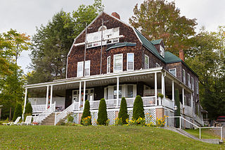
The Pennington Cottage is a historic home located at Deer Park, Garrett County, Maryland, United States. It is a 2+1⁄2-story, late-19th-century Shingle-Style frame structure, with a gambrel roof and a one-story porch that stretches across the principal facade and along portions of the sides. The house is entirely covered with dark wood shingles. It was built as a part of the Baltimore and Ohio Railroad's Deer Park Hotel complex, as the summer home of Baltimore architect Josias Pennington.

Stanton's Mill is a historic grist mill complex located at Grantsville, Garrett County, Maryland, consisting of five interrelated buildings and structures. The Stanton's Mill building dates from about 1797. It is two stories and constructed of heavy timber frame with a gable roof; an addition was constructed in 1890. The complex includes a stone-faced, mid-19th-century timber crib dam and raceway, natural earthen tailrace, and a small, single-span stone arch bridge, dating to 1813, constructed as part of the National Road. Also on the property is a frame storage building, constructed about 1900.

The Garrett County Courthouse is a historic county courthouse located at Oakland, Garrett County, Maryland, United States. It is a three-story, 1907–1908 neo-classical Renaissance Revival masonry structure in the form of a Latin Cross with a central rotunda and dome. The Courthouse was designed by James Riely Gordon (1863–1937), a New York architect who specialized in designing government buildings.

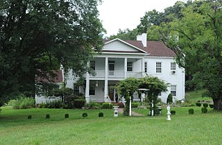
Brooklandville House, or the Valley Inn, is a historic restaurant and tavern building, and a former inn, located in Brooklandville, Baltimore County, Maryland. It is a 2+1⁄2-story stone structure facing the former railroad and dating from about 1832. It is associated with the Baltimore and Susquehanna Railroad, which crossed the property just to the south.


