
Karimnagar is also known as Elagandula is a city and District Headquarters in the Indian state of Telangana. Karimnagar is a major urban agglomeration and fifth largest City in the state. It is governed by Municipal corporation and is the headquarters of the Karimnagar district It is situated on the banks of Manair River, which is a tributary of the Godavari River.It is the third largest and fastest growing urban settlement in the state, according to 2011 census. It has registered a population growth rate of 45.46% and 38.87% respectively over the past two decades between 1991 and 2011, which is highest growth rate among major cities of Telangana. It serves as a major educational and health hub for the northern districts of Telangana. It is a major business center and widely known for its agricultural and granite industries, earning the nickname "City of Granites."

Nizamabad is also known as Induru is a city in the Indian state of Telangana. Nizamabad is a major urban agglomeration and third largest city in the state. It is governed by municipal corporation and is the headquarters of the Nizamabad district. Although previously part of Hyderabad State and then Andhra Pradesh state, Nizamabad became a part of the newly formed state of Telangana by the Andhra Pradesh Reorganisation Act, 2014.It is located about 186 kilometres (116 mi) north of the state capital, Hyderabad.
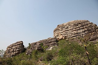
Dhulikatta is a village in Eligaid Mandal in Peddapalli district before it was in Karimnagar District in the state of Telangana earlier known as Andhra Pradesh in India. It is 15 km away from the Peddapalli District centre and 25 km from Karimnagar. The three day Satavahana festival is held there every year in January.

Jagtial is a city and the district headquarters of jagtial district of Telangana, India. It has an average elevation of 293 metres (961 ft). It is located about 190 kilometres (118 mi) north of the state capital Hyderabad.

Karimnagar district is one of the 33 districts of the Indian state of Telangana. Karimnagar city is its administrative headquarters. The district shares boundaries with Peddapalli, Jagityal, Sircilla, Siddipet, Jangaon, Hanamkonda district and Jayashankar Bhupalapally districts.

Nizamabad district is a district located in the north-western region of the Indian state of Telangana. The city of Nizamabad is the district headquarters. The district share boundaries with Jagtial, Sircilla, Nirmal, Kamareddy districts and with Nanded district of the state boundary of Maharashtra.

Korutla municipality is the second largest town and revenue division in the Jagtial district in the Indian state of Telangana. It is a historical town ruled by Jain Kings and second largest town in Jagtial district. It is the headquarters of Koratla constituency. It is located about 23 kilometres (14 mi) from the district headquarters Jagtial, 235 kilometers from Hyderabad, 73 kilometers from Karimnagar and 76 kilometers from Nizamabad.
Nirmal is a town and the district headquarters of Nirmal district in the Indian state of Telangana. It is famed for its toys made out of wood.
Armoor is a city in a Indian state Telangana in Nizamabad district, it is fastest growing city in the state and second biggest developed city in nizamabad district after nizamabad city, in the state of Telangana in India. Armoor is situated on NH 7 and NH 63. In earlier days, it was called Navanathapuram since it has nine mountains around the city Armoor is a variation of it.Armoor is one of fastest growing city in the Telangana state
Kammarpally is a village & mandal in the Nizamabad district in the state of Telangana in India. It is situated on National Highway 63.

Peddapalli is a town and Revenue Division in Peddapalli District in the Indian state of Telangana. It is the headquarters of the Peddapalli District and Peddapalli mandal. It is located about 197 kilometres North of the state capital Hyderabad, 36 kilometres from Karimnagar, 28 kilometres from Ramagundam. Peddapalli has a railway junction named PDPL which connects PDPL - KRMR - NZB railway line and New Delhi (NDLS) - Chennai Central (MAS) railway line. There are two trains that terminate here. Karimnagar Tirupati express rail engine changes to electric engine here. As of 2011 census of India, Peddapalli has a population of 41,171. In 2016 due to population Increase, the civic body of Peddapalli was upgraded from Nagar Panchayat to Municipal council Post upgradation to Council.
Sironcha is a town and municipal council in Gadchiroli district of Maharashtra state in India. It connected with NH-63.

Adilabad district is a district located in the northern region of Telangana, India. It is known as the gateway district to South and Central India. The town of Adilabad is its headquarters. The district shares boundaries with Asifabad, Nirmal districts and with the state boundary of Maharashtra.
Awadam or Avadam is a village in Mancherial district of the Indian state of Telangana. It is located in Nennal mandal. It falls under Bellampalli and Peddapalle.
Mancherial district is a district located in the northern region of the Indian state of Telangana. The district comprises 18 mandals and two revenue divisions – Mancherial and Bellampalli. The district headquarters is located at Mancherial town. It is surrounded by Komaram Bheem, Nirmal, Jagtial, Peddapalli and Bhupalpally districts of Telangana and with Maharashtra state.

Nirmal district is a district located in the northern region of the Indian state of Telangana. The district headquarters is located in the town of Nirmal. It borders the Telangana districts of Adilabad, Nizamabad, Mancherial, Asifabad, Jagtial districts as well as Nanded district of the state Maharashtra.

Kamareddy district is a district located in the northern region of the Indian state of Telangana. The district shares boundaries with Medak, Nizamabad, Sangareddy, Siddipet and Rajanna Sircilla districts and with the state boundary of Maharashtra and Karnataka.
Jayashankar Bhupalpally district is a district in the Indian state of Telangana. The district headquarters are located at Bhupalpally. It was a part of the erstwhile Warangal district and Karimnagar district prior to the re-organisation of districts in the state. The district share boundaries with Karimnagar, Mancherial, Peddapalli, Hanamkonda, Warangal, and Mulugu districts and with the state boundary of Maharashtra and Chhattisgarh.
Pedapalli district is a district located in the northern region of the Indian state of Telangana. Its administrative headquarters is at Peddapalli and Commissionerate is at Ramagundam. The district shares boundaries with Mancherial, Karimnagar, Jagtial and Jayashankar Bhupalpally districts. This district covers Ramagundam city which is situated in the Godavari valley coalfields and has one of the India's largest thermal power stations in south region under NTPC. Mostly industries are connected with Godavarikhani - NTPC - Ramagundam.

Rajanna Sircilla district is a district in the Indian state of Telangana. Sircilla is the district headquarters. The district shares boundaries with Karimnagar, Siddipet, Jagtial, Kamareddy, and Nizamabad districts.

