
Lake Travis is a reservoir on the Colorado River in central Texas in the United States.

The Colorado River is one of the principal rivers in the Southwestern United States and northern Mexico. The 1,450-mile-long (2,330 km) river drains an expansive, arid watershed that encompasses parts of seven U.S. states and two Mexican states. The name Colorado derives from the Spanish language for "colored reddish" due to its heavy silt load. Starting in the central Rocky Mountains of Colorado, it flows generally southwest across the Colorado Plateau and through the Grand Canyon before reaching Lake Mead on the Arizona–Nevada border, where it turns south toward the international border. After entering Mexico, the Colorado approaches the mostly dry Colorado River Delta at the tip of the Gulf of California between Baja California and Sonora.

Inks Lake is a reservoir on the Colorado River in the Texas Hill Country in the United States. The reservoir was formed in 1938 by the construction of Inks Dam by the Lower Colorado River Authority. Located near Burnet, Texas, the lake serves to provide flood control in tandem with Lake Buchanan and features the smallest hydroelectric power plant on the Highland Lakes chain. Inks Lake was named for Roy B. Inks, one of the original board members of the Lower Colorado River Authority, and serves as a venue for outdoor recreation, including fishing, boating, swimming, camping, and picnicking.

Glen Canyon Dam is a concrete arch-gravity dam on the Colorado River in northern Arizona, United States, near the town of Page. The 710-foot (220 m) high dam was built by the U.S. Bureau of Reclamation (USBR) from 1956 to 1966 and forms Lake Powell, one of the largest man-made reservoirs in the U.S. with a capacity of more than 25 million acre-feet (31 km3). The dam is named for Glen Canyon, a series of deep sandstone gorges now flooded by the reservoir; Lake Powell is named for John Wesley Powell, who in 1869 led the first expedition to traverse the Colorado River's Grand Canyon by boat.

Lake Mead is a reservoir formed by the Hoover Dam on the Colorado River in the Southwestern United States. It is located in the states of Nevada and Arizona, 24 mi (39 km) east of Las Vegas. It is the largest reservoir in the US in terms of water capacity. Lake Mead provides water to the states of Arizona, California, and Nevada as well as some of Mexico, providing sustenance to nearly 20 million people and large areas of farmland.

Lake Powell is an artificial reservoir on the Colorado River in Utah and Arizona, United States. It is a major vacation destination visited by approximately two million people every year. It is the second largest artificial reservoir by maximum water capacity in the United States behind Lake Mead, storing 25,166,000 acre-feet (3.1042×10¹⁰ m3) of water when full. However, Lake Mead has fallen below Lake Powell in size several times during the 21st century in terms of volume of water, depth and surface area.

Flaming Gorge Dam is a concrete thin-arch dam on the Green River, a major tributary of the Colorado River, in northern Utah in the United States. Flaming Gorge Dam forms the Flaming Gorge Reservoir, which extends 91 miles (146 km) into southern Wyoming, submerging four distinct gorges of the Green River. The dam is a major component of the Colorado River Storage Project, which stores and distributes upper Colorado River Basin water.

The Otay River is a river in southern San Diego County, California. The 25 mi (40 km) river begins at San Miguel Mountain, flows through the Upper and Lower Otay Reservoirs, and continues on between the southern part of the Chula Vista and the Otay Mesa West district of San Diego, to its river mouth on San Diego Bay.

A dam failure or dam burst is a catastrophic type of structural failure characterized by the sudden, rapid, and uncontrolled release of impounded water or the likelihood of such an uncontrolled release. Between the years 2000 and 2009 more than 200 notable dam failures happened worldwide.

John Redmond Reservoir is a reservoir on the Neosho River in eastern Kansas. Built and managed by the U.S. Army Corps of Engineers, it is used for flood control, recreation, water supply, and wildlife management. It borders the Flint Hills National Wildlife Refuge to the northwest.
Lake Pueblo State Park is a state park located in Pueblo County, Colorado. It includes 60 miles (97 km) of shoreline and 10,000 acres (40 km2) of land. Activities it offers include two full-service marinas, recreational fishing, hiking, camping and swimming at a special swim beach.

Vega State Park is a 1,823-acre (738 ha) Colorado state park in Mesa County, Colorado in the United States. Vega Reservoir is a fishing destination and is located at an elevation of 7,696 feet (2,346 m). Year-round recreational activities at Vega State Park include boating, hiking, snowmobiling and camping. The park was established in 1967 in cooperation with the Bureau of Reclamation which was responsible for the construction of Vega Dam and Vega Reservoir.
Antero Reservoir is a reservoir in the US state of Colorado. It was created by the first dam placed on the South Platte River in Park County, central Colorado. It is owned by Denver Water and supplies drinking water to the greater Denver metro region almost 140 miles (230 km) away.

Hauser Dam is a hydroelectric straight gravity dam on the Missouri River about 14 miles (23 km) northeast of Helena, Montana, in the United States. The original dam, built between 1905 and 1907, failed in 1908 and caused severe flooding and damage downstream. A second dam was built on the site in 1908 and opened in 1911 and comprises the present structure. The current Hauser Dam is 700 feet (210 m) long and 80 feet (24 m) high. The reservoir formed by the dam, Hauser Lake, is 25 miles (40 km) long, has a surface area of 3,800 acres (1,500 ha), and has a storage capacity of 98,000 acre-feet (121,000,000 m3) of water when full.

Khandoli Dam is a dam located 10 km North-East of Giridih town towards Bengabad in Jharkhand, India. Khandoli is also an important tourist spot at the foot of the Khandoli hill. The reservoir of the Khandoli dam provides water supply to more than one lakh residents of the Giridih city.

Lovewell Reservoir is a reservoir in Jewell County, Kansas, United States. Built and managed by the U.S. Bureau of Reclamation, it is used for flood control, irrigation, and recreation. Lovewell State Park is located on its north shore.

Cedar Bluff Reservoir is a reservoir in Trego County, Kansas, United States. Built and managed by the U.S. Bureau of Reclamation for irrigation and area water supply, it is also used for flood control and recreation. Cedar Bluff State Park is located on its shore.

Elkhead Reservoir State Park is a Colorado state park located in Moffat and Routt counties in northwest Colorado, near Craig. The park surrounds and includes the 900 surface acre Elkhead Reservoir. It is referred to as Elkhead State Park. Elkhead Reservoir State Park is managed as a complex out of the Yampa River State Park office, located to the west of the town of Hayden, CO.
The Marble Canyon Dam, also known as the Redwall Dam, was a proposed dam on the Colorado River in Arizona. The dam was intended to impound a relatively small reservoir in the central portion of Marble Canyon to develop hydroelectric power. Plans centered on two sites between miles 30 and 40 in the canyon. At one point a 38-mile (61 km) tunnel was proposed to a site just outside Grand Canyon National Park to develop the site's full power generation potential, reducing the Colorado River to a trickle through the park.
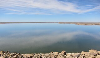
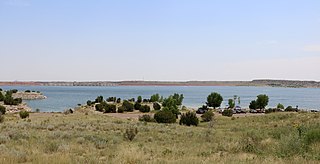
John Martin Reservoir is a reservoir on the Arkansas River in southeastern Colorado. Built and managed by the U.S. Army Corps of Engineers, it is used for flood control, irrigation, and recreation. John Martin Reservoir State Park lies on its shore.

