The Arapaho are a Native American people historically living on the plains of Colorado and Wyoming. They were close allies of the Cheyenne tribe and loosely aligned with the Lakota and Dakota.

Effigy Mounds National Monument preserves more than 200 prehistoric mounds built by pre-Columbian Mound Builder cultures, mostly in the first millennium CE, during the later part of the Woodland period of pre-Columbian North America. Numerous effigy mounds are shaped like animals, including bears and birds.

The Sand Creek massacre was a massacre of Cheyenne and Arapaho people by the U.S. Army in the American Indian Wars that occurred on November 29, 1864, when a 675-man force of the Third Colorado Cavalry under the command of U.S. Volunteers Colonel John Chivington attacked and destroyed a village of Cheyenne and Arapaho people in southeastern Colorado Territory, killing and mutilating an estimated 69 to over 600 Native American people. Chivington claimed 500 to 600 warriors were killed. However, most sources estimate around 150 people were killed, about two-thirds of whom were women and children. The location has been designated the Sand Creek Massacre National Historic Site and is administered by the National Park Service. The massacre is considered part of a series of events known as the Colorado Wars.

Black Kettle was a leader of the Southern Cheyenne during the American Indian Wars. Born to the Northern Só'taeo'o / Só'taétaneo'o band of the Northern Cheyenne in the Black Hills of present-day South Dakota, he later married into the Wotápio / Wutapai band of the Southern Cheyenne.

John Evans was an American politician, physician, founder of various hospitals and medical associations, railroad promoter, governor of the territory of Colorado, and namesake of Evanston, Illinois; Evans, Colorado; and formerly Mount Evans, Colorado.

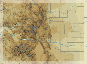
The Colorado War was an Indian War fought in 1864 and 1865 between the Southern Cheyenne, Arapaho, and allied Brulé and Oglala Sioux peoples versus the U.S. Army, Colorado militia, and white settlers in Colorado Territory and adjacent regions. The Kiowa and the Comanche played a minor role in actions that occurred in the southern part of the Territory along the Arkansas River. The Cheyenne, Arapaho, and Sioux played the major role in actions that occurred north of the Arkansas River and along the South Platte River, the Great Platte River Road, and the eastern portion of the Overland Trail. The United States government and Colorado Territory authorities participated through the 1st Colorado Cavalry Regiment, often called the Colorado volunteers. The war was centered on the Colorado Eastern Plains, extending eastward into Kansas and Nebraska.

The 3rd Colorado Cavalry Regiment was a Union Army unit formed in the mid-1860s when increased traffic on the United States emigrant trails and settler encroachment resulted in numerous attacks against them by the Cheyenne and Arapaho. The Hungate massacre and the display in Denver of mutilated victims raised political pressure for the government to protect its people. Governor John Evans sought and gained authorization from the War Department in Washington to found the Third. More a militia than a military unit, the "Bloodless Third" was composed of "100-daysers," that is, volunteers who signed on for 100 days to fight against the Indians. The unit's only commander was Col. George L. Shoup, a politician from Colorado. The regiment was assigned to the District of Colorado commanded by Col. John M. Chivington.

Bent's Old Fort is a fort located in Otero County in southeastern Colorado, United States. A company owned by Charles Bent and William Bent and Ceran St. Vrain built the fort in 1833 to trade with Southern Cheyenne and Arapaho Plains Indians and trappers for buffalo robes. For much of its 16-year history, the fort was the only major white American permanent settlement on the Santa Fe Trail between Missouri and the Mexican settlements. It was destroyed in 1849.

William Wells Bent was a frontier trader and rancher in the American West, with forts in Colorado. He also acted as a mediator among the Cheyenne Nation, other Native American tribes and the expanding United States. With his brothers, Bent established a trade business along the Santa Fe Trail. In the early 1830s Bent built an adobe fort, called Bent's Fort, along the Arkansas River in present-day Colorado. Furs, horses and other goods were traded for food and other household goods by travelers along the Santa Fe trail, fur-trappers, and local Mexican and Native American people. Bent negotiated a peace among the many Plains tribes north and south of the Arkansas River, as well as between the Native American and the United States government.

Medicine Bow–Routt National Forest is the official title to a U.S. Forest Service managed area extending over 2,222,313 acres (8,993.38 km2) in the states of Wyoming and Colorado, United States. What were once three separate areas, Medicine Bow National Forest, Routt National Forest, and Thunder Basin National Grassland were administratively combined in 1995 due to similarity of the resources, proximity to each other and for administrative purposes.
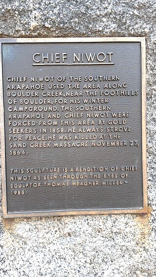
Chief Niwot or Left Hand(-ed) was a Southern Arapaho chief, diplomat, and interpreter who negotiated for peace between white settlers and the Cheyenne and Arapaho tribes during the Pike's Peak Gold Rush and Colorado War.

The Land Run of 1892 was the opening of the Cheyenne-Arapaho Reservation to settlement in the U.S. state of Oklahoma. One of seven in Oklahoma, it occurred on April 19, 1892, and opened up land that would become Blaine, Custer, Dewey, Washita, and Roger Mills counties. The land run also opened up what would become part of Ellis County, but was designated County "E" and then Day County prior to statehood.
Bear Creek is a tributary of the South Platte River in central Colorado in the United States. It begins as a small creek up in the Mount Blue Sky Wilderness in Summit Lake and makes its way through Evergreen, CO, Kittredge, CO, Idledale, CO and Morrison, CO before entering Bear Creek Lake Park, managed by the City of Lakewood, Colorado.
The Hungate massacre involved the murder of the family of Nathan Hungate along Running Creek on June 11, 1864. It was a precipitating factor leading to the Sand Creek massacre of November 29, 1864.

Fort Weld, also called Camp Weld, began as a military camp on 30 acres east of the Platte River in what is now the La Alma-Lincoln Park neighborhood of Denver, Colorado. It was named for Lewis Ledyard Weld, the first Territorial Secretary. The central square of the post was used to practice drills of the troops. Buildings—soldier's quarters, officers' headquarters, mess rooms, a hospital, and a guard house—surrounded the square. The main entrance to the camp was on the eastern side of the post. It was established on September 1861 and abandoned in 1865.

Amache Ochinee Prowers, also known as Walking Woman, was a Native American activist, advocate, cattle rancher, and operator of a store on the Santa Fe Trail. Her father was a Cheyenne peace chief who was killed during the Sand Creek massacre on November 29, 1864, after which she became a mediator between Colorado territorial settlers, Mexicans, and Native Americans during the 1860s and 1870s. She was inducted into the Colorado Women's Hall of Fame in 2018.

John Wesley Prowers was an American trader, cattle rancher, legislator, and businessman in the territory and state of Colorado. Married to Amache Prowers, a Cheyenne woman, his father-in-law was a Cheyenne chief who negotiated for peace and was killed during the Sand Creek massacre.

Ochinee, also known as Lone Bear and One-Eye, was a Native American Peace Chief of the Cheyenne tribe. He was the father of Amache Prowers, a tradeswoman, advocate and leader among the Southern Cheyenne. Ochinee, who had worked to create peace for the Cheyenne, died during the Sand Creek massacre on November 29, 1864.
Margaret Poisal was "the only woman who was an official witness, interpreter, and consultant at many meetings and treaty councils held along or in close proximity to the Santa Fe Trail." The daughter of French Canadian trapper John Poisal and Arapaho Snake Woman, Poisal was educated at a convent school. She married Thomas Fitzpatrick, an Indian agent, and they worked together negotiating peace between Native American tribes and the United States government. After Fitzpatrick died, Poisal continued to work as an interpreter and peacemaker.