
Gales Ferry is a village in the town of Ledyard, Connecticut, United States. It is located along the eastern bank of the Thames River. The village developed as a result of having a ferry to Uncasville located at this site, and from which the village was named. Gales Ferry was listed as a census-designated place for the 2010 Census, with a population of 1,162.

This is a list of the National Register of Historic Places listings in Olmsted County, Minnesota. It is intended to be a complete list of the properties and districts on the National Register of Historic Places in Olmsted County, Minnesota, United States. The locations of National Register properties and districts for which the latitude and longitude coordinates are included below, may be seen in an online map.

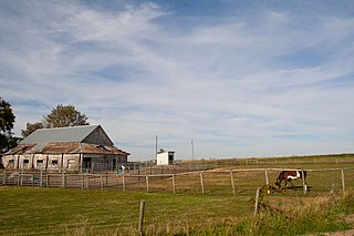
Sinking Springs Farms is a historic farm and national historic district located at Manchester Township in York County, Pennsylvania.
The William and Amanda J. Ellis Farmstead Historic District is a nationally recognized historic district located near Elliott, Iowa, United States. It was listed on the National Register of Historic Places in 2015. At the time of its nomination it contained four resources, which included two contributing buildings, and two non-contributing buildings. William and Amanda Jane Ellis owned this farm from 1882 to 1919. During that time the Queen Anne style house with Stick influences and the heavy timber frame barn were built. Both were constructed around 1900. Two garages are the non-contributing buildings.
The William A. Leet and Frederick Hassler Farmstead District, also known as the Leet/Hassler Farmstead or Glenhaven, is a nationally recognized historic district located in Manning, Iowa, United States. It was listed on the National Register of Historic Places in 1999. At the time of its nomination it contained 12 resources, which included four contributing buildings, three contributing structures, four contributing objects, and one non-contributing building.
The Duncan–Duitsman Farm Historic District is a nationally recognized agricultural historic district located northeast of George, Iowa, United States. It was listed on the National Register of Historic Places in 1994. At the time of its nomination it contained 19 resources, which included 12 contributing buildings, four contributing sites, one contributing structure, and two non-contributing buildings. Its historic importance is derived from being two pioneer farmsteads from the last section of Iowa opened to settlement.
The Poplar Rural District is a nationally recognized historic district located north of Jacksonville, Iowa, United States. It was listed on the National Register of Historic Places in 1992. At the time of its nomination the district consisted of 55 resources, including 29 contributing buildings, one contributing site, five contributing structures, one contributing object, 15 non-contributing buildings, and four non-contributing structures. The 36 contributing resources include three houses, 12 barns, 14 outbuildings, which are all included as buildings. The three corn cribs and the two granaries/corn cribs are the structures. A concrete post fence line is the object, and the landscape of the district is the site. They are all associated with the largest rural settlement of Danish immigrants in the United States. The farmsteads are located on the hilltops or along the hillsides. The latter appear to be somewhat linked to the ethnic heritage of the Danish immigrants who tended to locate their farmsteads on sheltered hillsides. The period of significance starts with the construction of the original Jackson #1 schoolhouse in 1884, and concludes with the construction of the second Jackson #1 schoolhouse in 1923.

The Reeves Farmstead Historic District is a nationally recognized historic district located north of Le Mars, Iowa, United States. It was listed on the National Register of Historic Places in 2001. At the time of its nomination the district consisted of 13 resources, including 11 contributing buildings, one non-contributing building, and one non-contributing object. The contributing buildings include an American Four Square house, a barn, cob house and wash house, hen house, outhouse, machine shed, corn crib, two hog houses, and a garage. The non-contributing building is a second garage built in the late 20th century, and the non-contributing object is an incomplete wind mill. The buildings were all built in the late 19th- or early 20th century, but exact dates are uncertain. The fully integrated farmstead from the early to mid 20th century features buildings that utilize simple architecture that was typical of many Iowa farms. It was removed from the National Register of Historic Places in 2020.

The August H.J. and Justena Lange Farmstead Historic District is an agricultural historic district located northeast of La Porte City, Iowa, United States. It was listed on the National Register of Historic Places in 1997. At the time of its nomination it consisted of 16 resources, which included seven contributing buildings, two contributing structures, one contributing objects, three non-contributing buildings, and three non-contributing structures. The farmstead was developed from 1887, when the Lange's took possession of the property, and 1916 when they moved into La Porte City. They had a general farming operation here that was augmented by August's specialized skill as a blacksmith. The farmstead was organized spatially with the domestic buildings on the west side of Spring Creek Road and the farming operation on the east side.

The John and Marie (Palen) Schrup Farmstead Historic District is a nationally recognized historic district in Dubuque County, Iowa, United States. It was listed on the National Register of Historic Places in 2009. At the time of its nomination it consisted of four resources, which included three contributing buildings and one non-contributing building. The three buildings include a stone house, barn, and well-house. The buildings are typical of those constructed by immigrant families from Luxembourg that settled in Dubuque and nearby Jackson counties. The front part of the house is the oldest structure here and was built when Martin Burkhart owned the property. He sold the farmstead to Casper Burkhart the following year, who then sold it to John and Marie Schrup in 1856. The Schrups were responsible for adding onto the back of the house about the time they bought it and the other two buildings. The dairy farm of 193 acres (78 ha) remained in the family until 1973. Because it was always a modest enterprise, the stone buildings were not torn down and replaced with modern structures as happened on many of the Luxembourgian farms built in the mid-19th century. A wooden shed was built in the early 20th century, and is the non-contributing building. A pole barn was also added to the farmstead and it fell down c. 1995.
John A. Adams Farmstead Historic District, also known as Cedarcroft Farm, is a historic home and farm and national historic district located near Warrensburg, Johnson County, Missouri. The district consists of four contributing properties—three contributing buildings and one contributing structure. The buildings are a house, a barn, and a barn. The structure is a system of sewer and drainage tiles and dams constructed beginning in 1875 and which underlays much of the district.

The Jan F. and Antonie Janko Farmstead District is an agricultural historic district located west of Ely, Iowa, United States. It was listed on the National Register of Historic Places in 2000. At the time of its nomination it consisted of seven resources, which included five contributing buildings, one contributing structure, and one non-contributing structure. The historic buildings include a two-story, wood frame, side gable house (1887); a gabled basement barn ; a gabled barn (1893); chicken house, and a single-stall garage (1910s-1930s). The corncrib is the historic structure. A three-stall garage (1972) is the non-contributing structure. The farmstead is located on a hilltop and sideslope. The house sits on the highest elevation, with the outbuildings located down the slope to the west and southwest.
The Josias L. and Elizabeth A. Minor Farmstead District is an agricultural historic district located northwest of Ely, Iowa, United States. It was listed on the National Register of Historic Places in 2000. At the time of its nomination it consisted of five resources, which included four contributing buildings and one non-contributing structure. The historic buildings include a 1+1⁄2-story, T-plan, half-timbered house (1856); gabled barn #1 ; gabled barn #2 ; and the summer kitchen (1850s). The corncrib is the historic structure. Family lore says that Josias Minor settled here in 1846, but an 1878 biography of him gives September 1855 as the settlement date, which is used here for dating the buildings.

The Podhajsky-Jansa Farmstead District is an agricultural historic district located southwest of Ely, Iowa, United States. It was listed on the National Register of Historic Places in 2000. At the time of its nomination it consisted of 12 resources, which included five contributing buildings, four contributing structures, and three non-contributing structures. The historic buildings include two small side gabled houses ; a two-story, frame, American Foursquare house ; a gabled barn that was moved here from another farm ; and a feeder barn. One of two corncribs (1933), a hog house, and a chicken house are the historic structures. Another corncrib and a couple of metal sheds from the mid to late 20th century are the non-contributing structures.

The Camp Harlan-Camp McKean Historic District, also known as the Hugh B. and Mary H. Swan Farmstead and the Springdale Stock Farm, is a nationally recognized historic district located northwest of Mount Pleasant, Iowa, United States. It was listed on the National Register of Historic Places in 2013. At the time of its nomination it consisted of eight resources, which includes two contributing buildings, one contributing site, one contributing object and four non-contributing buildings.

The Gregorius and Mary Hanka Farmstead is a historic farmstead in Embarrass Township, Minnesota, United States. It was established by a Finnish immigrant family around 1910 and includes four surviving buildings constructed with traditional Finnish log architecture. The farm was listed as a historic district on the National Register of Historic Places in 1990 for its state-level significance in the themes of agriculture, architecture, and European ethnic heritage. It was nominated for reflecting the successful conversion of St. Louis County's cutover forests into productive agricultural land by Finnish immigrants, and their use of traditional log architecture.
The Meyers Farmstead Historic District, also known as the Jacob E. and Amanda Meyers Farm and the John B. and Ella Meyers Farm, is an agricultural historic district located in Lisbon, Iowa, United States. It was listed on the National Register of Historic Places in 2021. At the time of its nomination it consisted of six resources, which included two contributing buildings, two contributing structures, and two contributing objects. The historic buildings include a heavy timber frame Pennsylvania banked barn (1870s) and a feeder/hay barn. The historic structures include a combination corn crib/hog house (1880s) and a concrete silo. The contributing objects include a concrete watering trough and water pump and a metal gateway. The farmhouse is also extant but was separated from the rest of the farm buildings when South Jefferson Street was extended in 2002. That separation and the modifications made to it over the years has led to its loss of historical integrity
The Raritan–Readington South Branch Historic District is a 556-acre (225 ha) historic district along River Road from New Jersey Route 31 to U.S. Route 202 near Flemington in Hunterdon County, New Jersey. It is primarily on the western side of the South Branch Raritan River in Raritan Township. It extends onto the eastern side of the river in Readington Township. County Route 523 and County Route 612 pass through the district to the north. The district encompasses the small settlements of Holcomb Mills, Flemington Junction, and Rockefellows Mills. It was added to the National Register of Historic Places on January 26, 1990, for its significance in architecture, politics, transportation, and exploration/settlement. The district includes 36 contributing buildings, four contributing structures, and three contributing sites. It also includes the John Reading Farmstead, previously listed on the NRHP individually.

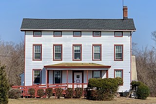
The Sharpenstine Farmstead is a historic farmhouse located at 98 East Mill Road near Long Valley in Washington Township, Morris County, New Jersey. It was added to the National Register of Historic Places on May 1, 1992, for its significance in architecture. The 22.4-acre (9.1 ha) farm overlooks the valley formed by the South Branch Raritan River. The house is part of the Stone Houses and Outbuildings in Washington Township Multiple Property Submission (MPS).
The W.L. and Winnie (Woodfield) Belfrage Farmstead Historic District is a nationally recognized historic district located south of Sergeant Bluff, Iowa, United States. It was listed on the National Register of Historic Places in 2017. At the time of its nomination it contained six resources, which included four contributing buildings and two non-contributing buildings. The four contributing buildings are the dairy barn (1910), farmhouse (1920), brooder house, and the chicken coop. The two no-contributing buildings are the cattle shed (1960) and the garage/utility building (2006).


