
Gairsain is the summer capital of the Indian state of Uttarakhand. A town and Nagar Panchayat, Gairsain is situated at the eastern edge of the vast Dudhatoli mountain range, and is located in Chamoli district almost at the centre of the state, at a distance of approximately 250 kilometres from Dehradun. It is easily accessible from both the Garhwal and the Kumaon divisions, and in a way, acts as the bridge between the two regions. It is being considered as the future Permanent capital of Uttarakhand.
Didihat is a town and a Nagar Palika in Pithoragarh District in the state of Uttarakhand, India. It is one of the eleven administrative subdivisions of Pithoragarh district and also serves as its administrative headquarter. With a population of 6522, Didihat is located at a distance of 415 km (258 mi) from the state capital Dehradun.

Namik Glacier is situated in the Pithoragarh district of Uttarakhand state in India. The glacier is situated on the Kumaon Himalayas at an altitude of 3,600 m (11,800 ft). This glacier is the source of the Ramganga River. The glacier is surrounded by the following peaks: Nanda Devi 7,848 metres (25,748 ft), Nanda Kot 6,861 metres (22,510 ft), and Trishuli 7,120 metres (23,360 ft). The glacier falls on ancient Indo-Tibet trade route. It is 23 km (14 mi) trekking from Liti and situated at the villages of Gogina and Namik. There are a number of waterfalls and sulphur springs originating around this glacier. The glacier can be reached by trekking from gogina on the sama liti Road near. It is 63 kilometres (39 mi) from Bageshwar. Jeeps can be hired from Bageshwar or Kapkot up to Gogina. 'Namik' means a place where saline water springs are present.

Bageshwar is a district of Uttarakhand state in northern India. The town of Bageshwar is the district headquarters. Prior to its establishment as a district in 1997 it was part of Almora district.
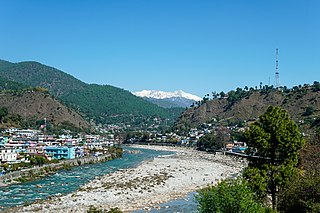
Bageshwar is a town and a municipal board in Bageshwar district in the state of Uttarakhand, India. It is located at a distance of 470 km from the National Capital New Delhi and 332 km from the State Capital Dehradun. Bageshwar is known for its scenic environment, glaciers, rivers and temples. It is also the administrative headquarters of Bageshwar district.

The Sarayu (Kumaoni:Sarjyū) is a river that originates at a ridge south of Nanda Kot mountain in Bageshwar district in Uttarakhand, India. It flows through Kapkot, Bageshwar, and Seraghat towns before discharging into the Sharda River at Pancheshwar at the India-Nepal border. Sharda river then flows into Ghaghara river in Sitapur District, Uttar Pradesh, India.

Almora is a municipal board and a cantonment town in the state of Uttarakhand, India. It is the administrative headquarters of Almora district. Almora is located on a ridge at the southern edge of the Kumaon Hills of the Himalaya range, at a distance of 363 km from the national capital New Delhi and 415 km via Saharanpur Rd, 351 km via NH109 and 388.6 km via Ambala- Dehradun- Haridwar Rd from the state capital Dehradun. According to the provisional results of the 2011 national census of India, Almora has a population of 35,513. Nestled within higher peaks of the Himalaya, Almora enjoys a year-round mild temperate climate. The town is visited by thousands of tourists annually from all over the world. Almora has beautifully been able to maintain its sanctity all over these years. There are total 11 Blocks in Almora district.

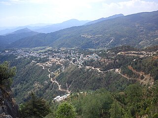
Chaukori is a hill station in the Pithoragarh district set among the lofty peaks of the western Himalayan Range in the Kumaon Division of Uttarakhand, India. To its north is Tibet and to its south is Terai. The Mahakali River, running along its eastern boundary, forms the Indo-Nepal international border. This place has become a prominent tourist place and from here a wide and picturesque view of Himalayan range can be viewed. The golden yellow colour of sun rays falling on the Himalayan range in the morning time is really worth seeing. There are cottages available here where one can stay and enjoy the serene surroundings. Tourists coming to this place generally also visit the nearby tourist places like Patal Bhuvaneshwar, Kausani, Bageshwar and Almora.
Kausani is a hill station and Village situated in Bageshwar district in the state of Uttarakhand, India. It is famous for its scenic splendour and its spectacular 300 km-wide panoramic view of Himalayan peaks like Trisul, Nanda Devi and Panchchuli. Mahatma Gandhi called this place the 'Switzerland of India', due to similarity in landscapes.

Bhagat Singh Koshyari is an Indian politician serving as the 22nd and current Governor of Maharashtra from 5 September 2019. An RSS veteran, Koshyari served as National Vice-President of BJP and party's 1st State president for Uttarakhand. He also served as 2nd Chief Minister of Uttarakhand from 2001 to 2002 and thereafter, he was the leader of the opposition in the Uttarakhand Legislative Assembly from 2002 to 2003. He has also served as an MLC in Uttar Pradesh Legislative Council and MLA in Uttarakhand Legislative Assembly. Later Served as an MP in Rajya Sabha from 2008 to 2014 from Uttarakhand and then the MP in the 16th Lok Sabha from Nainital-Udhamsingh Nagar constituency, earning him the distinction of being elected in both houses of State Legislature and both houses of National Parliament respectively.

Baijnath is a small town on the banks of the Gomati river in the Bageshwar district in Kumaon division of Uttarakhand, India. The place is most noted for its ancient temples, which have been recognized as Monuments of National Importance by the Archaeological Survey of India in Uttarakhand. Baijnath has been selected as one of the four places to be connected by the 'Shiva Heritage Circuit' in Kumaon, under the Swadesh Darshan Scheme of the Government of India.

Kanda is a small historic, scenic town and tehsil in Bageshwar district, in the state of Uttarakhand, India.

Bagnath Temple is an ancient shrine dedicated to Shiva, situated in the Bageshwar city at the confluence of Sarayu and Gomati rivers. Bagnath Temple is festooned with bells of all sizes and features impressive carvings. It is the most famous Temple in Bageshwar District. It is flooded with devotees on the occasion of Shivratri. The city of Bageshwar gets its name from this Temple.

Gomati is a tributary of the Saryu River. The river originates in the higher reaches of Bhatkot northwest to the town of Baijnath in Uttarakhand, India. It joins Saryu at Bageshwar, which then proceeds towards Pancheshwar where it joins the Kali River.

Someshwar is the name of the sub-division headquarters, a conglomeration of revenue villages and it also refers to the entire region as Someshwar Tehsil and Sub Division in the Almora District in the hill-state of Uttarakhand, India.
Sani Udiyar is a Village situated in Kanda Tehsil in Bageshwar district in the State of Uttarakhand, India. It is located at a distance of 15 kilometres (9.3 mi) from Kanda and 36 kilometres (22 mi) from Bageshwar. Sani Udiyar is a medium-sized village with total 88 families residing. It has substantial population of people belonging to Schedule Caste.

The Sarju, also known as Saryu, is a major river draining Central Kumaon region in the Indian state of Uttarakhand. Originating from Sarmul, Sarju flows through the cities of Kapkot, Bageshwar and Seraghat before joining Mahakali at Pancheshwar. The Sarju is the largest tributary of the Sharda River. The river forms the South-eastern border between the districts of Pithoragarh and Almora. Temperate and sub-Tropical forests cover the entire Catchment area of the River.
Mankot is a Village situated in Bageshwar district in the State of Uttarakhand, India. It is located at a distance of 18 kilometres (11 mi) from Bageshwar on the National Highway 309A. Mankot is a medium-sized village with total 114 families residing.
The Coolie-Begar movement was a non-violent movement by the general public of Kumaun in the Bageshwar town of United Provinces in 1921. This movement was led by Badri Datt Pandey, who was awarded the title of 'Kumaon Kesari' after the success of this movement. The aim of this movement was to put pressure on the British to end the practice of Coolie-Begar. Mahatma Gandhi, while praising the movement, named it 'Bloodless Revolution'.

Badhangarhi temple is an ancient Hindu temple dedicated to Lord kali, worshipped as Maa Dakshineshwar kaali or Bhagwati. People living in Tharali, Naranbagar, Dewal block of chamoli and garur, kapkot block of Bageshwar have a great faith in Badhangarhi, a popular deity in this region. It is situated in Tharali tehsil of Chamoli Garhwal district of Uttarakhand. The nearest town to Badhangarhi is Gwaldam which is 8 km from the main Badhangarhi temple. The temple is situated at the elevation of about 2260 m.

