
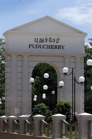
Puducherry, also known as Pondicherry, is a union territory of India, consisting of four small geographically unconnected districts. It was formed out of four territories of former French India, namely Pondichéry, Karikal (Karaikal), Mahé and Yanaon, excluding Chandannagar (Chandernagore), and it is named after the largest district, Puducherry, which was also the capital of French India. Historically known as Pondicherry, the territory changed its official name to Puducherry on 1 October 2006.
Karaikal is a town of the Indian Union Territory of Puducherry. Karaikal was sold to the French by the Rajah of Thanjavur and became a French Colony in 1739. The French held control, with occasional interruptions from the British, until 1954, when it was de facto incorporated into the Republic of India, along with Mahé, Yanaon, and Pondichéry.

Cuddalore, also spelt as Kadalur, is the city and headquarters of the Cuddalore District in the Indian state of Tamil Nadu. Situated south of Chennai, Cuddalore was an important city and port during the British Raj.
Velankanni (Vēḷāṅkaṇṇi), is a Special Grade Panchayat Town in Nagapattinam district in the Indian state of Tamil Nadu. It lies on the Coromandel Coast of the Bay of Bengal, 350 km south of Chennai (Madras), 12 km south of Nagapattinam, and 33 km southeast of Thiruvarur.
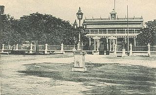
Pondicherry is the capital and most populous city of the Union Territory of Puducherry in India. The city is in the Puducherry district on the southeast coast of India and is surrounded by the Bay of Bengal to the east and the state of Tamil Nadu, with which it shares most of its culture, heritage, and language.

Nagapattinam district is one of the 38 districts of Tamil Nadu state in southern India. Nagapattinam district was carved out by bifurcating the erstwhile composite Thanjavur district on 19 October 1991. The town of Nagapattinam is the district headquarters.
Tindivanam is a town and a municipality in Viluppuram district in the Indian state of Tamil Nadu. It is the second largest town in Villupuram District after the headquarters town Villupuram. Important roads from north to south Tamil Nadu pass through Tindivanam and similarly from west to east.

East Coast Road (ECR), combination of SH-49, NH-332A, NH-32, officially known as Mutthamizh Arignar Kalaignar Road without public voting, is a two-lane highway in Tamil Nadu, India, built along the Bay of Bengal coast. It connects Tamil Nadu's state capital Chennai with Kanyakumari via Puducherry, Cuddalore, Chidambaram, Sirkali, Thirukkadaiyur, Tharangambadi, Karaikal, Nagore, Nagapattinam, Thiruthuraipoondi, Muthupet, Adirampattinam, Manora,Peravurani,Manamelkudi, Mimisal, Ramanathapuram, Rameswaram,Thoothukudi, Tiruchendur, Uvari, Kudankulam. The total length of the road is about 777 km between Chennai and Kanyakumari.
The Puducherry district, also known by its former name Pondicherry district, is one of the four districts of the union territory of Puducherry in South India. The district occupies an area of 290 square kilometres (110 sq mi), spread over 12 non-contiguous enclaves lying on or near the Bay of Bengal within a compact area in the state of Tamil Nadu. According to the 2011 census, the district has a population of 950,289.

Pondicherry University, also known as PU, is a central research university located in Kalapet, Pondicherry in Union Territory of Puducherry, India. It was established by an Act of Parliament in 1985 by the Department of Higher Education, Ministry of Education, Government of India. The Vice President of India is the Chancellor along with the Lieutenant Governor of Puducherry acting as the Chief Rector and the President of India is the Visitor of the university. The university is a collegiate university with its jurisdiction spread over the Union Territory of Puducherry located in Tamil Nadu, Kerala (Mahé) and Andhra Pradesh (Yanam), and Union Territory of Andaman and Nicobar Islands. The vast jurisdiction over three Union Territories namely gives the university a national character. The residents speak diverse languages such as English, Tamil, French, Telugu, Malayalam, Hindi, Bengali, Oriya, assamese, and Kannada.

Viluppuram, Villupuram, or Vizhuppuram is a municipality and the administrative headquarters of Viluppuram district.
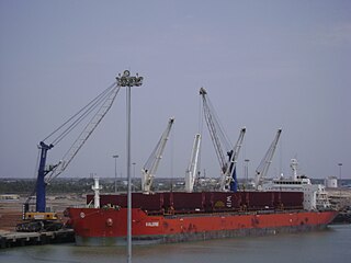
Karaikal Port Private Limited a private port developed by the Chennai based MARG Limited, became operational in April, 2009. It is located on the Eastern coast of India in Karaikal around 300 km south of Chennai Port and around 360 km north of Tuticorin Port.
The Puducherry Road Transport Corporation is the government transport corporation in the union territory of Puducherry that provides services in all the four regions of Puducherry, namely Pondicherry, Karaikal, Mahé and Yanam.

12°2′4.93″N79°51′52.24″E
Christianity in Puducherry originated with the Capuchins from Madras who began their missionary activity here. By 1689, the Jesuits began their activity, and in 1773 the Paris Foreign Missions Society continued the mission. At that time, there were 30,000 Catholics in Pondicherry. However, the lack of missionaries and opposition from Padroado mutated the mission.

Tiruchirappalli railway division(Tamil:[திருச்சிராப்பள்ளிரயில்கோட்டம்]) is one of the six railway divisions of Southern Railway zone (SR) of India. It has its administrative headquarters located at Tiruchirappalli. It serves most of the districts of delta region and Central Tamil Nadu.
The town of Viluppuram in the Indian state of Tamil Nadu is well connected by both rail and road to other major cities in the state including Chennai, Trichy, Madurai, Salem, Thanjavur, Coimbatore, Dindigul and Vellore. And also other state major cities such as Bengaluru, Tirupati, Pondicherry and Mangalore. Viluppuram serves as one of the important railway junction of Tamil Nadu and Southern Railway Zone. The nearest domestic airport is Pondicherry, which has a daily chartered flight to Bengaluru. The nearest international airports are Chennai and Tiruchirappalli.
The Pondichérien diaspora is a demographic group of people from Puducherry state of India who have emigrated and settled in other parts of the world, significantly in France, Réunion and the French Caribbean islands of Martinique and Guadeloupe. There are around 300,000 of them living around the world.
Jawahar Navodaya Vidyalaya, Karaikal or locally known as JNV Varichikudy is a boarding, co-educational school in Karaikal district of Puducherry U.T. in India. Navodaya Vidyalayas are funded by the Indian Ministry of Human Resources Development and administered by Navodaya Vidyalaya Smiti, an autonomous body under the ministry. Navodaya Vidyalayas offer free education to talented children from Class VI to XII. Karaikal district is a coastal enclave within Tamil Nadu state, located about 132 km from union territory headquarter Pondicherry.


