Khambhat

Last updated

Khambhat
Cambay
City
City of Khambaht(Tower Area).jpg
Tower Road, Khambhat
Nickname: 
Trambavati Nagari
India Gujarat location map.svg
Red pog.svg
Khambhat
Coordinates: 22°18′N72°37′E / 22.3°N 72.62°E / 22.3; 72.62
CountryIndia
State Gujarat
District Anand
Government
  Type Nagar Palika
Area
  Total2,932.9 km2 (1,132.4 sq mi)
Population
 (2011)
  Total99,164 (M+OG)
  Density620/km2 (1,600/sq mi)
Languages
  Official Gujarati
Time zone UTC+5:30 (IST)
PINs
388620, 388625, 388630, 388540
Telephone code02698
Vehicle registration GJ 23
Website khambhatnagarpalika.in

Khambhat ( /kɑːmˈbɑːt/ , Gujarati: [kʰəmbʱɑt] ), also known as Cambay, is a city and the surrounding urban agglomeration in Anand district in the Indian state of Gujarat. [1] It was once an important trading center, but its harbour gradually silted up, and the maritime trade moved to Surat. Khambat lies on an alluvial plain at the north end of the Gulf of Khambhat, noted for the extreme rise and fall of its tides, which can vary as much as thirty feet in the vicinity of Khambat. Khambat is known for its halvasan sweet, sutarfeni, akik stone and kites (patang), and for sources of oil and gas.

Contents

Khambat is perhaps the only place in India where the Harappan craft of agate bead making is found in the living tradition. Surprisingly Khambat has no stone deposits; the craft has survived mainly through acquiring stones from the Rajpipla hills, about 200 km away from the city. In the folklore of Khambat, the beginning of the craft is attributed to Baba Ghor, a 1500 AD saint from Ethiopia (Habash) who had led a large contingent of Muslims (Siddi) to settle in the city. However, in the archaeological record the origin of the craft can be traced to nearby Lothal, a Harappan outpost that flourished about 4000 years ago.

Toponymy

Origin of name

Some people believe that the City of Khambat may be the Camanes of Ptolemy. James Tod believed that the name comes from the Sanskrit Khambavati or 'City of the Pillar'.

Variants of name

Historical

History

Mohman Khan Nawab of Cambay Mohman Khan Nawab of Cambay.jpg
Mohman Khan Nawab of Cambay
Mausoleum of 1st Wali-ul-Hind Moulai Abdullah, Khambat, Gujarat, 1050AD-1100AD. Moulai Abadullah khambhat.JPG
Mausoleum of 1st Wali–ul–Hind Moulai Abdullah, Khambat, Gujarat, 1050AD-1100AD.
The city of Cambay was an important Indian manufacturing and trading center noted by Marco Polo and illustrated here in the 15th century. Illustration of The city of Cambay in the 15th century.jpg
The city of Cambay was an important Indian manufacturing and trading center noted by Marco Polo and illustrated here in the 15th century.
The king of Cambay (in present-day Gujarat) from "Figurae variae Asiae et Africae," a 16th-century Portuguese manuscript in the Casanatense Library in Rome (Codex Casanatense 1889). Ludovico-di-Varthema-King-of-Khambat-16th-century-India.jpg
The king of Cambay (in present-day Gujarat) from "Figurae variae Asiae et Africae," a 16th-century Portuguese manuscript in the Casanatense Library in Rome (Codex Casanatense 1889).

Cambay was formerly a flourishing city, the seat of an extensive trade, and celebrated for its manufactures of silk, chintz and gold stuffs. [7] The Arab traveler al-Mas'udi visited the city in 915 AD, describing it as a very successful port; it was mentioned in 1293 by Marco Polo, who, calling it Cambaet, noted it as a busy port. He mentions that the city had its own king. Indigo and fine buckram were particular products of the region, but much cotton and leather was exported through Cambay. In the early 1340s, the Moroccan traveller Ibn Battuta remarked on its impressive architecture and cosmopolitan population. [8]

"Cambay is one of the most beautiful cities as regards the artistic architecture of its houses and the construction of its mosques. The reason is that the majority of its inhabitants are foreign merchants, who continually build there beautiful houses and wonderful mosques -- an achievement in which they endeavour to surpass each other."

An Italian traveler, Marino Sanudo, said that Cambeth was one of India's main two ocean ports. Another Italian, visiting in about 1440, Niccolò de' Conti, mentions that the walls of the city were twelve miles in circumference. The Kothi gateway traditionally believed to be constructed by an English factory is in fact a 14th-century gate, probably dating to the 1330s, of Tughluq era. [9]

The Portuguese explorer Duarte Barbosa visited the city, which he calls Cambaia, in the early sixteenth century. [10] His description of the city is very full. He states:

"Entering by Guindarim [Gandhar port, Bharuch], [11] which is within on the river, there is a great and fair city called Cambaia in which dwell both 'mouros' [Muslims] and 'gentios' [Hindus]. Therein are many fair houses, very lofty, with windows and roofed with tiles in our manner, well laid out with streets and fine open places, and great buildings of stone and mortar." [12] (translation of [10] )

He describes the city as very busy and affluent, with merchants coming frequently by sea from the world around. Duarte Barbosa also noted that many ships from the Kingdom of Cambaya sailed to the Sultanate of Mogadishu in the Horn of Africa with cloths and spices for which they in return received gold, wax and ivory. [13]

Owing principally to the gradually increasing difficulty of access by water by the silting up of the gulf, its commerce has long since fallen away, and the City became poor and dilapidated. The spring tides rise upwards of 30 ft (10 m) and in a channel usually so shallow that it is a serious danger to shipping. By 1900, the trade was chiefly confined to the export of cotton. The City was celebrated for its manufacture of agate and carnelian ornaments, of reputation, principally in China. [7]

The houses in many instances are built of stone (a circumstance which indicates the former wealth of the city, as the material had to be brought from a very considerable distance); and remains of a brick wall, three miles (five km) in circumference, which formerly surrounded the City, enclose four large reservoirs of good water and three bazaars. To the southeast there are very extensive ruins of subterranean temples and other buildings half-buried in the sand by which the ancient City was overwhelmed. These temples belong to the Jains and contain two massive statues of their deities: one black, the other white. The principal one, as the inscription intimates, is Pariswanath or Parswanath, carved in the reign of the emperor Akbar; the black one has the date of 1651 inscribed. [7]

A few members of Shia community settled in Khambhat during 18th century from Iran. Among these the most known was Nawab Mohammed Jaffar Ali Khan Najamesani and his son Nawab Yavar Ali khan Najamesani. Nawab Yavar Ali khan Najamesani ruled 84 villages when he was crowned as a Nawab. Nawab Yavar Ali Khan was titled Sarkar Sahab (Governing Prince), because he was able to maintain peace and unity. The name Cambay to Khambhat was also given by Nawab Yavar Ali Khan during Pre-independence period. Nawab Yavar Ali Khan died in July 1996. His family still lives in Khambhat.[ citation needed ]

Hub of mercantile activity

The traders and the merchants reached here from across the world. Cambay was known for its cotton and silk cloths. Cambay was one of India's most active trade center since the 14th century (Source: Ibn Battuta). After 200 years, Duarte Barbosa described Cambay as an important commercial center with carpets, and other textile goods in Mughal established industries. [14]

Cambay cloth

Cambay was famous for its cloth manufacturing and trading activities. There were certain coarse cotton cloths which were called Cambay cloth. [15] For instance, the checked cloths. [16] There are records of extensive trading of Gujarati Cambay cloth. [17] [18]

Princely State of Cambay

Cambay flag of Royal family of Nawab Jaffar Ali Khan najamesani. Cambayflag.png
Cambay flag of Royal family of Nawab Jaffar Ali Khan najamesani.

Khambat was the capital of Cambay State, a princely state of British India. It was the only state in the Kaira Agency of the Gujarat division of the Bombay Presidency. It had an area of 350 sq mi (910 km2). It was founded in 1730, at the time of the dismemberment of the Mughal Empire. The Nawabs of Cambay were descendants of Mumin Khan, the last of the Mughal governors of Gujarat, who in 1742 defeated his brother-in-law Nizam Khan, governor of Khambhat, [7] and established himself there. [19]

The sport of cricket in India was first played in Cambay State in 1721. [20]

In 1780 Cambay was taken by the army of general Goddard Richards, but it was restored to the Marathas in 1783. Finally it was ceded to the British by the Peshwa under the treaty of 1803. The state was provided with a railway in 1901. [7]

Geography and Climate

Khambhat is at 22°18′N72°37′E / 22.3°N 72.62°E / 22.3; 72.62 . [21] It has an average elevation of 8 metres (26 ft).

Khambhat has warm and humid climate. It is located on the plains. The land on which Khambhat sits is the silt deposited by the Mahi River, so Khambhat has very fertile, wet coastal alluvial soil. The area south of Khambhat is muddy wetlands and then coast line comes. Normally April to June is summer. From July, it rains until September. It has a muggy climate for most of the year except winters. Sometimes Khambhat receives heavy rain, and surrounding areas get affected from floods in the Mahi River. Mid November to January is winter, which results in essentially mild cold during the nights and early mornings with warm noons. Maximum average temperatures are 25 to 30 °C (77 to 86 °F) and minimum average temperatures are 10 to 12 °C (50.0 to 53.6 °F). Summer average maxima are 38 °C or 100.4 °F and minima around 22 °C or 71.6 °F. In summer, high winds are common. Khambhat coast's tides are among the highest in the world at up to 35 feet or 10.7 metres. [22]

Creative artwork in a mosque Creative artwork in a mosque.jpg
Creative artwork in a mosque

Demographics

As of 2011 India census, [23] Khambhat had a population of 201,964. Males constitute 52% of the population and females 48%. Khambhat has an average literacy rate of 73%, higher than the national average of 59.5%: male literacy is 78%, and female literacy is 67%. In Khambhat, 10% of the population is under 6 years of age.

Economy

In the 14th and 15th centuries, Khambhat was well known for Muslim gravestones carved in marble which were exported to various locations along the Indian Ocean rim, including Southeast Asia. [24]

Many here are in the agate business, diamond cutting-polishing & colored stone business (mainly ruby), and have shops which sell eatables and household products. Kite making is another important business in the City among few particular communities. Fishing and salt harvesting are other businesses some particular communities are occupied with.

Transport

Railway

Khambhat is connected with Anand by Railway Line. Total 8 trains depart per day for Anand.

Road

Khambhat is connected with Tarapur, Dharmaj, Vataman, Petlad, Nadiad, Anand, undel and Dali by Regional roads.

Schools

Colleges

Tourism

Uttarayana at Khambhat Kite fastival in gujarat.jpg
Uttarayana at Khambhat
Shivling, Ralaj, Khambhat Shivling, Ralaj,Khambhat, Gujarat.jpg
Shivling, Ralaj, Khambhat

Marine archeology

In May 2001, India's Union Minister for Human Resource Development, Science and Technology division, Murli Manohar Joshi, announced that the ruins of an ancient civilization had been discovered off the coast of Gujarat, in the Gulf of Khambhat. The site was discovered by NIOT while they performed routine pollution studies using SONAR, and was described as an area of regularly spaced geometric structures. It is located 20 km from the Gujarat coast, spans 9 km, and can be found at a depth of 30–40 meters. In his announcement, Joshi represented the site as an urban settlement that pre-dates the Indus Valley civilization. However, these claims were made without the backing of any experts and have since been debunked by prominent archaeologists. [25]

See also

Related Research Articles

<span class="mw-page-title-main">Marine archaeology in the Gulf of Khambhat</span> Archaeological exploration along Western Indian coast

Marine Archeology in the Gulf of Khambhat - earlier known as Gulf of Cambay - centers around controversial findings made in December 2000 by the National Institute of Ocean Technology (NIOT) under the Gulf of Khambhat, a bay on the Arabian Sea on the west coast of India. The structures and artifacts discovered by NIOT are the subject of contention. The major disputes surrounding the Gulf of Khambhat Cultural Complex (GKCC) are claims about the existence of submerged city-like structures, the difficulty associating dated artifacts with the site itself, and disputes about whether stone artifacts recovered at the site are actually geofacts or artifacts. One major complaint is that artifacts at the site were recovered by dredging, instead of being recovered during a controlled archeological excavation. This leads archeologists to claim that these artifacts cannot be definitively tied to the site. Because of this problem, prominent archeologists reject a piece of wood that was recovered by dredging and dated to 7500 BC as having any significance in dating the site. The surveys were followed up in the following years and two palaeo channels of old rivers were discovered in the middle of the Khambhat area under 20–40 m (66–131 ft) water depths, at a distance of about 20 km (12 mi) from the present day coast.

<span class="mw-page-title-main">Gujarat</span> State in western India

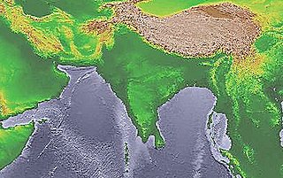
Gujarat is a state along the western coast of India. Its coastline of about 1,600 km (990 mi) is the longest in the country, most of which lies on the Kathiawar peninsula. Gujarat is the fifth-largest Indian state by area, covering some 196,024 km2 (75,685 sq mi); and the ninth-most populous state, with a population of 60.4 million in 2011. It is bordered by Rajasthan to the northeast, Dadra and Nagar Haveli and Daman and Diu to the south, Maharashtra to the southeast, Madhya Pradesh to the east, and the Arabian Sea and the Pakistani province of Sindh to the west. Gujarat's capital city is Gandhinagar, while its largest city is Ahmedabad. The Gujaratis are indigenous to the state and their language, Gujarati, is the state's official language.

<span class="mw-page-title-main">Surat</span> City in Gujarat, India

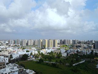
Surat is a city in the western Indian state of Gujarat. The word Surat literally means face in Urdu, Gujarati and Hindi. Located on the banks of the river Tapti near its confluence with the Arabian Sea, it used to be a large seaport. It is now the commercial and economic center in South Gujarat, and one of the largest urban areas of western India. It has well-established diamond and textile industry, and is a major supply centre for apparels and accessories. About 90% of the world's diamonds are cut and polished in Surat. It is the second largest city in Gujarat after Ahmedabad and the eighth largest city by population and ninth largest urban agglomeration in India. It is the administrative capital of the Surat district. In recent years, Surat has been noted for achieving a Guinness World Record for the largest gathering for a yoga session at one place where 153,000 people joined the event on International Yoga Day(21st June 2023).

<span class="mw-page-title-main">Muslim period in the Indian subcontinent</span> Era in South Asia characterized by Muslim rule

Muslim period in the Indian subcontinent is conventionally said to have started in 712, after the conquest of Sindh and Multan by the Umayyad Caliphate under the military command of Muhammad ibn al-Qasim. It began in the Indian subcontinent in the course of a gradual conquest. The perfunctory rule by the Ghaznavids in Punjab was followed by Ghurids, and Sultan Muhammad of Ghor is generally credited with laying the foundation of Muslim rule in Northern India.

<span class="mw-page-title-main">Muhammad Shah</span> Mughal emperor from 1719 to 1748

Mirza Nasir-ud-Din Muḥammad Shah was the thirteenth Mughal emperor from 1719 to 1748. He was son of Khujista Akhtar, the fourth son of Bahadur Shah I. After being chosen by the Sayyid Brothers of Barha, he ascended the throne at the young age of 16, under their strict supervision.

<span class="mw-page-title-main">Sonargaon</span> Historic city in central Bangladesh

Sonargaon is a historic city in central Bangladesh. It corresponds to the Sonargaon Upazila of Narayanganj District in Dhaka Division.

<span class="mw-page-title-main">Nawabs of Bengal</span> Rulers of Eastern India and Bengal in the 18th-century

The Nawab of Bengal was the hereditary ruler of Bengal Subah in Mughal India. In the early 18th-century, the Nawab of Bengal was the de facto independent ruler of the three regions of Bengal, Bihar and Orissa which constitute the modern-day sovereign country of Bangladesh and the Indian states of West Bengal, Bihar and Odisha. They are often referred to as the Nawab of Bengal, Bihar and Orissa. The Nawabs were based in Murshidabad which was centrally located within Bengal, Bihar, and Odisha. Their chief, a former prime minister, became the first Nawab. The Nawabs continued to issue coins in the name of the Mughal Emperor, but for all practical purposes, the Nawabs governed as independent monarchs. Bengal continued to contribute the largest share of funds to the imperial treasury in Delhi. The Nawabs, backed by bankers such as the Jagat Seth, became the financial backbone of the Mughal court. During the 18th century, the Nawabs of Bengal were among the wealthiest rulers in the world.

Ghogha is a census town in Bhavnagar district in the state of Gujarat, India. It is situated on the mid-western bank of the Gulf of Khambhat. It was an important historical commercial port on the Arabian Sea until the development of nearby Bhavnagar in the nineteenth century.

<span class="mw-page-title-main">Alamparai Fort</span>

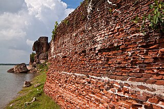
The ruins of Alamparai Fort lie near Kadappakkam in India, a village 50 km from Mamallapuram on the land overlooking the sea. Constructed in the late 17th century during the Mughal era, the Alamparai Fort once had a 100-metre long dockyard stretching into the sea, from which zari cloth, salt, and ghee were exported. During 1735 AD it was ruled by Nawab Doste Ali Khan. In 1750, for the services rendered by the famous French commander Dupleix to Subedar Muzaphar Jung, the fort was given to the French. When French were defeated by the British, the fort was captured and demolished in 1760 AD. More recently the structure was damaged in the 2004 Indian Ocean earthquake.

The term Gujarati Muslim is usually used to signify an Indian Muslim from the state of Gujarat in western coast of India. Most Gujarati Muslims have the Gujarati language as their mother tongue, but some communities have Urdu as their mother tongue. The majority of Gujarati Muslims are Sunni, with a minority of Shi'ite groups.

<span class="mw-page-title-main">Flags of the Mughal Empire</span> Banners and standards of the South Asian early modern empire

The Mughal Empire had a number of imperial flags and standards. The principal imperial standard of the Mughals was known as the alam. It was primarily moss green. It displayed a lion and sun facing the hoist of the flag. The Mughals traced their use of the alam back to Timur.

<span class="mw-page-title-main">Malik Ayyaz</span>

Malik Ayyaz, called Meliqueaz by the Portuguese, was a naval officer and governor of the city of Diu, in the mouth of the Gulf of Khambhat (Cambay), circa 1507–1509 under the rule of Gujarat Sultanate. He was one of the most distinguished warriors of his time.

<span class="mw-page-title-main">Pathans of Gujarat</span> Indian people of Pashtun origin

GujaratiPathans are a group of Pashtuns, who are settled in the region of Gujarat in western India. They now form a distinct community of Gujarati and Urdu/Hindi speaking Muslims. They mainly speak Urdu/Hindi with many Pashto loanwords, but most of them have been Indianized so some may have Gujarati as their first language as well, few elders in the community still speak Pashto. Common tribes include Turk pathan, Babi or Babai, Niazi, Khan, Bangash, Durrani, and Yousafzai.

Rander is a town in Surat district in the state of Gujarat, India. Located on the bank of the Tapti River, it is 2 kilometres (1.2 mi) from the city of Surat.

<span class="mw-page-title-main">Cambay State</span> Princely state in India during the British Raj

Khambhat state or Cambay state was a princely state in India during the British Raj. The city of Khambhat in present-day Gujarat was its capital. The state was bounded in the north by the Kaira district and in the south by the Gulf of Khambhat.

<span class="mw-page-title-main">History of Surat</span> City in India

Surat was founded in the late medieval period, and gradually became an important port in the Mughal Empire, though the earliest human presence may go as early as 300 BCE. The Maratha rulers defeated the Mughals during the Battle of Surat. Later, the Dutch ruled the area and the city became known as Dutch Suratte.

Gujarat, a region in western India, fell under Delhi Sultanate following repeated expeditions under Alauddin Khalji around the end of the 13th century. He ended the rule of Vaghela dynasty under Karna II and established Muslim rule in Gujarat. Soon the Tughluq dynasty came to power in Delhi whose emperor carried out expeditions to quell rebellion in Gujarat and established their firm control over the region by the end of the century. Following Timur's invasion of Delhi, the Delhi Sultanate weakened considerably so that the last Tughluq governor Zafar Khan declared himself independent in 1407 and formally established the Gujarat Sultanate.

In 1573, Mughal Emperor Akbar conquered Gujarat Sultanate taking advantage of young Gujarat Sultan Muzaffar Shah III and his quarrelling nobles. Muzaffar was held captive at Agra. He appointed his foster brother Mírza Âzíz Kokaltásh as the first viceroy who faced an insurrection by the rebel nobles of the former Sultanate. Akbar quickly came to aid and ended the insurrection. He soon appointed Mírza Khán who managed to set revenue system and quelled attack by the Mirzas with help of Mughal minister Todar Mal. The next viceroy Shaháb-ud-dín strengthened the military. Soon Sultan Muzaffar escaped, returned to Gujarat and led an attack on Ahmedabad and recaptured it before his former noble and now viceroy Itimad Khan reach the city. Soon Mirza Khan was reappointed as the viceroy who defeated Muzaffar in the battle of Fatehwadi in 1584. Soon Kokaltásh returned as the viceroy and defeated Muzaffar and combined Kathiawad forces in battle of Bhuchar Mori. Later Muzaffar was captured but he committed suicide, putting an end to the Gujarat Sultanate. As Kokaltásh went to the Mecca on pilgrimage, Sultan Murad Bakhsh was appointed as the viceroy on whose death, Kokaltásh returned third time as the viceroy. Akbar was succeeded by Jehangir.

<span class="mw-page-title-main">Gujarat Subah</span> Former Mughal imperial province

The Gujarat Subah was a province (subah) of the Mughal Empire, encompassing the Gujarat region. The region first fell under Mughal control in 1573, when the Mughal emperor Akbar defeated the Gujarat Sultanate under Muzaffar Shah III. Muzaffar tried to regain the Sultanate in 1584 but failed. Gujarat remained the Mughal province governed by the viceroys and officers appointed by the Mughal emperors from Delhi. Akbar's foster brother Mirza Aziz Kokaltash was appointed as the subahdar (viceroy) who strengthened Mughal hold over the region. The nobles of former Sultanate continued to resist and rebel during the reign of the next emperor Jahangir (1605–1627) but Kokaltash and his successor subahdars subdued them. Jehangir also permitted the British East India Company to establish factories in Surat and elsewhere in Gujarat. The next emperor Shah Jahan (1627–1658) expanded his territories in south and his subahdars made hold over Kathiawar peninsula including Nawanagar. Shah Jahan had also appointed his prince Aurangzeb, who was involved in religious disputes, prince Dara Shikoh and later prince Murad Bakhsh as subahdars. Following battle of succession, Aurangzeb (1658–1707) came to the Mughal throne and his policies resulted in revolts and discontent. During his reign, the Marathas under Shivaji raided Surat (1666) and their incursions in Gujarat started. Till then Gujarat prospered due to political stability, peace and growing international trade.

The Architecture of Gujarat consists of architecture in the Indian state of Gujarat.

References

  1. "Alphabetical List of Towns and their Population: Gujarat" (PDF). Census of India 2010. Office of The Registrar General & Census Commissioner, Ministry of Home Affairs, Government of India. Archived (PDF) from the original on 24 November 2007.
  2. Polo, Marco; Pisa, Rustichello (c. 1300). The Travels of Marco Polo.
  3. Duarte Barbosa; Mansel Longworth Dames (15 May 2017). The Book of Duarte Barbosa: An Account of the Countries bordering on the Indian Ocean and their Inhabitants: Written by Duarte Barbosa, and Completed about the year 1518 A.D, Volume 2. Taylor & Francis. ISBN   9781317040149.
  4. Lock, Peter (2013). Marino Sanudo Torsello, The Book of the Secrets of the Faithful of the Cross: Liber Secretorum Fidelium Crucis. Ashgate Publishing, Ltd. p. 49. ISBN   978-1-4094-8210-9.
  5. 1 2 3 4 "Hobson-Jobson/C". Wikisource.
  6. Rennell, James (1788). Memoir of a Map of Hindoostan; Or, The Mogul Empire: With an Introduction, Illustrative of the Geography and Present Division of that Country: and a Map of the Countries Situated Between the Head of the Indus, and the Caspian Sea. M. Brown. p. 136.
  7. 1 2 3 4 5 Wikisource-logo.svg One or more of the preceding sentences incorporates text from a publication now in the public domain :  Chisholm, Hugh, ed. (1911). "Cambay". Encyclopædia Britannica . Vol. 5 (11th ed.). Cambridge University Press. p. 81.
  8. Baṭṭūṭa, Ibn; Husain, Mahdi (1976). The Rehla of Ibn Battuta (India, Maldive Islands and Ceylon). Baroda: Oriental Institute. p. 172.
  9. Lambourn, Elizabeth (1 October 2002). "The English factory or Kothī gateway at Cambay: an unpublished Tughluq structure from Gujarat". Bulletin of the School of Oriental and African Studies. 65 (3): 495–517. doi:10.1017/S0041977X02000307. ISSN   1474-0699.
  10. 1 2 Livro em que dá relação do que viu e ouviu no Oriente. p. 77 sq.
  11. "The Book Of Duarte Barbosa Vol. 1". Internet Archive.
  12. "The Book Of Duarte Barbosa Vol. 1". Internet Archive. 1918.
  13. Page 18 - A description of the coasts of East Africa and Malabar in the beginning of the sixteenth century,by Duarte Barbosa, a Portuguese. Tr. from an early Spanish manuscript in the Barcelona library; with notes and a preface, by the Hon. Henry E.J.Stanley" : PDF
  14. Walker, Daniel (1997). Flowers Underfoot: Indian Carpets of the Mughal Era. p. 5.
  15. "Indian Trade Cloths". asiantextileart.com. Retrieved 11 January 2021.
  16. Peck, Amelia (2013). Interwoven Globe: The Worldwide Textile Trade, 1500-1800. Metropolitan Museum of Art. p. 305. ISBN   978-1-58839-496-5.
  17. Kumar, Raj (2008). Encyclopaedia of Untouchables Ancient, Medieval and Modern. Gyan Publishing House. p. 231. ISBN   978-81-7835-664-8.
  18. Gazetteer of the Bombay Presidency: Rewa Kántha, Nárukot, Cambay, and Surat states. Government Central Press. 1880. p. 191.
  19. Princely States of India
  20. Clement Downing (1737). A Compendious History of the Indian Wars with an Account of the Rise, Progress, Strength and Forces of Angria the Pyrate. Also the Transactions of a Squadron of Men of War under Commodore Mathews sent to East-Indies to suppress the Pyrates. To which is annex'd, An Additional History of Wars between the Great Mogul , Angria, and his Allies, With an Account of the Life and Actions of John Plantain, a notorious Pyrate, at Madagascar, his Wars, with the Natives on that Island, where having continued eight Years, he join'd Agria, and was made his chief Admiral, by Clement Downing, Midshipman on board the Salisbury, afterwards Lieutenant of the Victory frigate, Fame Gally, and Revenge Grab, part of the Squadron employ'd by the East India Company to attack Angria; and sometimes Engineer in the service of the Great Mogul. pp.  228–229.
  21. Khambhat is between the tropical and subtropical climatic zone.Falling Rain Genomics, Inc – Khambhat
  22. A. S. Unnikrishnan, S. R. Shetye and G. S. Michael. "Tidal propagation in the Gulf of Khambhat, Bombay High, and surrounding areas". Journal of Earth System Science. 108 (3): 155–177.
  23. "Khambhat Population (2020/2021), Taluka Village List in Anand, Gujarat". www.indiagrowing.com. Retrieved 3 July 2021.
  24. Lambourn, Elizabeth (2004). "Carving and Communities: Marble Carving for Muslim Patrons at Khambhāt and around the Indian Ocean Rim, Late Thirteenth–Mid-Fifteenth Centuries". Ars Orientalis. 34: 99–133.
  25. Bavadam, Lyla. "Questionable claims: Archaeologists debunk the claim that underwater structures in the Gulf of Khambhat point to the existence of a pre-Harappan civilisation." Frontline 2–15 March 2002. .