Levasy, Missouri

Last updated
Levasy, Missouri
Jackson County Missouri Incorporated and Unincorporated areas Levasy Highlighted.svg
Location of Levasy, Missouri
Coordinates: 39°8′7″N94°7′56″W / 39.13528°N 94.13222°W / 39.13528; -94.13222 Coordinates: 39°8′7″N94°7′56″W / 39.13528°N 94.13222°W / 39.13528; -94.13222
Country United States
State Missouri
County Jackson
Government
  MayorPhyllis Dieckmann
Area
[1]
  Total0.60 sq mi (1.56 km2)
  Land0.60 sq mi (1.56 km2)
  Water0.00 sq mi (0.00 km2)
Elevation
[2]
709 ft (216 m)
Population
 (2020)
  Total77
  Density127.91/sq mi (49.37/km2)
Time zone UTC-6 (Central (CST))
  Summer (DST) UTC-5 (CDT)
ZIP code
64066
Area code 816
FIPS code 29-41762 [3]
GNIS feature ID0720926 [2]

Levasy is a city in Jackson County, Missouri, United States. The population was 83 at the 2010 census. It is part of the Kansas City metropolitan area.

Contents

History

A post office called Levasy has been in operation since 1877. [4] The city was named after William Wallace Livesay, an early settler. [5]

Geography

According to the United States Census Bureau, the city has a total area of 0.60 square miles (1.55 km2), all land. [6]

Demographics

Historical population
CensusPop.Note
1910 66
1920 146121.2%
1930 21547.3%
1940 126−41.4%
1950 13910.3%
1960 1400.7%
1970 283102.1%
1980 235−17.0%
1990 27918.7%
2000 108−61.3%
2010 83−23.1%
2020 77−7.2%
U.S. Decennial Census [7]

2010 census

At the 2010 census there were 83 people in 39 households, including 27 families, in the city. The population density was 138.3 inhabitants per square mile (53.4/km2). There were 47 housing units at an average density of 78.3 per square mile (30.2/km2). The racial makup of the city was 97.6% White and 2.4% from two or more races. Hispanic or Latino of any race were 3.6%. [8]

Of the 39 households, 20.5% had children under the age of 18 living with them, 56.4% were married couples living together, 5.1% had a female householder with no husband present, 7.7% had a male householder with no wife present, and 30.8% were non-families. 28.2% of households were one person, and 10.3% were one person aged 65 or older. The average household size was 2.13 and the average family size was 2.56.

The median age was 50.3 years. 14.5% of residents were under the age of 18; 4.7% were between the ages of 18 and 24; 24% were from 25 to 44; 39.7% were from 45 to 64; and 16.9% were 65 or older. The gender makeup of the city was 48.2% male and 51.8% female.

2000 census

As of the census [3] of 2000, there were 108 people in 40 households, including 33 families, in the city. The population density was 187.1 inhabitants per square mile (72.2/km2). There were 46 housing units at an average density of 79.7 per square mile (30.8/km2). The racial makup of the city was 99.07% White and 0.93% Native American.

Of the 40 households, 25.0% had children under the age of 18 living with them, 70.0% were married couples living together, 7.5% had a female householder with no husband present, and 17.5% were non-families. 17.5% of households were one person, and 7.5% were one person aged 65 or older. The average household size was 2.70 and the average family size was 2.97.

In the city the population was spread out, with 24.1% under the age of 18, 5.6% from 18 to 24, 29.6% from 25 to 44, 25.0% from 45 to 64, and 15.7% 65 or older. The median age was 42 years. For every 100 females, there were 107.7 males. For every 100 females age 18 and over, there were 105.0 males.

The median household income was $51,250 and the median family income was $60,250. Males had a median income of $40,000 versus $24,688 for females. The per capita income for the city was $17,016. There were 3.2% of families and 5.1% of the population living below the poverty line, including 3.3% of under eighteens and 23.1% of those over 64.

Related Research Articles

<span class="mw-page-title-main">Richfield, Idaho</span> City in Idaho, United States

Richfield is a city in Lincoln County, Idaho, in the United States. The population was 482 at the 2010 census.

<span class="mw-page-title-main">Rinard, Iowa</span> City in Iowa, United States

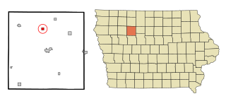
Rinard is a city in Calhoun County, Iowa, United States. The population was 38 at the time of the 2020 census.

<span class="mw-page-title-main">Grand River, Iowa</span> City in Iowa, United States

Grand River is a city in northwest Decatur County, Iowa, United States. The population was 196 at the time of the 2020 census.

<span class="mw-page-title-main">Wyoming, Iowa</span> City in Iowa, United States

Wyoming is a city in Jones County, Iowa, United States. The population was 523 at the time of the 2020 census. It is part of the Cedar Rapids Metropolitan Statistical Area.

<span class="mw-page-title-main">Cotter, Iowa</span> City in Iowa, United States

Cotter is a city in western Louisa County, Iowa, United States. The population was 39 at the 2020 census. It is part of the Muscatine Micropolitan Statistical Area.

<span class="mw-page-title-main">Macksburg, Iowa</span> City in Iowa, United States

Macksburg is a city in Madison County, Iowa, United States. The population was 97 at the time of the 2020 census. It is part of the Des Moines–West Des Moines Metropolitan Statistical Area.

<span class="mw-page-title-main">Patterson, Iowa</span> City in Iowa, United States

Patterson is a city in Madison County, Iowa, United States. The population was 176 at the time of the 2020 census. It is part of the Des Moines–West Des Moines Metropolitan Statistical Area.

<span class="mw-page-title-main">Gilman, Iowa</span> City in Iowa, United States

Gilman is a city in the southeastern corner of Marshall County, Iowa, United States. The population was 542 at the time of the 2020 census.

<span class="mw-page-title-main">Havelock, Iowa</span> City in Iowa, United States

Havelock is a city in Pocahontas County, Iowa, United States. The population was 130 at the time of the 2020 census.

<span class="mw-page-title-main">Westphalia, Iowa</span> City in Iowa, United States

Westphalia is a city in Shelby County, Iowa, United States. The population was 126 at the time of the 2020 census.

<span class="mw-page-title-main">Spring Hill, Iowa</span> City in Iowa, United States

Spring Hill is a city in Warren County, Iowa, United States. The population was 68 at the time of the 2020 census. It is part of the Des Moines–West Des Moines Metropolitan Statistical Area.

<span class="mw-page-title-main">West Chester, Iowa</span> City in Iowa, United States

West Chester is a city in Washington County, Iowa, United States. It is part of the Iowa City, Iowa Metropolitan Statistical Area. The population was 144 at the time of the 2020 census.

<span class="mw-page-title-main">Kensett, Iowa</span> City in Iowa, United States

Kensett is a city in Worth County, Iowa, United States. The population was 257 at the time of the 2020 census. It is part of the Mason City Micropolitan Statistical Area.

<span class="mw-page-title-main">Aldrich, Minnesota</span> City in Minnesota, United States

Aldrich is a city in Wadena County, Minnesota, United States, along the Partridge River. The population was 48 at the 2010 census. The small community holds the distinction as the first permanent settlement in Wadena County and the first to establish a post office. It is also home to the first Catholic church in the area, established in 1870, as a mission church.

<span class="mw-page-title-main">New Hampton, Missouri</span> City in Missouri, United States

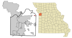
New Hampton is a city in southwest Harrison County, Missouri, United States. The population was 228 at the 2020 census.

<span class="mw-page-title-main">Unity Village, Missouri</span> Village in Missouri, United States

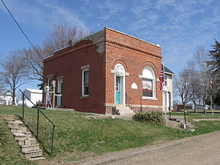
Unity Village is a village in Jackson County, Missouri, United States, bordering Kansas City and Lee's Summit. Its population was 99 at the 2010 census. It is the world headquarters of Unity Church, which has over 2 million followers. The Unity Tower was designed by the Kansas City firm Boillot & Lauck and built in 1929 to store water. Unity Village is part of the Kansas City metropolitan area.

<span class="mw-page-title-main">Dwight, North Dakota</span> City in North Dakota, United States

Dwight is a city in Richland County, North Dakota, United States. The population was 80 at the 2020 census. Dwight was founded in 1881. It is part of the Wahpeton, ND–MN Micropolitan Statistical Area.

<span class="mw-page-title-main">Bryant, South Dakota</span> City in South Dakota, United States

Bryant is a city in Hamlin County, South Dakota, United States. It is part of the Watertown, South Dakota Micropolitan Statistical Area. The population was 471 at the 2020 census. The mayor is named Win Noem.

<span class="mw-page-title-main">Whitewood, South Dakota</span> City in South Dakota, United States

Whitewood is a city in Lawrence County, South Dakota, United States. The population was 879 at the 2020 census.

<span class="mw-page-title-main">Readstown, Wisconsin</span> Village in Wisconsin, United States

Readstown is a village in Vernon County, Wisconsin, United States. The population was 415 at the 2010 census.

References

  1. "ArcGIS REST Services Directory". United States Census Bureau. Retrieved August 28, 2022.
  2. 1 2 U.S. Geological Survey Geographic Names Information System: Levasy, Missouri
  3. 1 2 "U.S. Census website". United States Census Bureau . Retrieved 2008-01-31.
  4. "Post Offices". Jim Forte Postal History. Retrieved 16 October 2016.
  5. "Jackson County Place Names, 1928–1945 (archived)". The State Historical Society of Missouri. Archived from the original on 24 June 2016. Retrieved 16 October 2016.{{cite web}}: CS1 maint: bot: original URL status unknown (link)
  6. "US Gazetteer files 2010". United States Census Bureau. Archived from the original on 2012-01-25. Retrieved 2012-07-08.
  7. "Census of Population and Housing". Census.gov. Retrieved June 4, 2015.
  8. "U.S. Census website". United States Census Bureau . Retrieved 2012-07-08.