Leavenworth County, Kansas

Last updated

Leavenworth County
Leavenworth county kansas courthouse 2009.jpg
Leavenworth County Courthouse in Leavenworth
Map of Kansas highlighting Leavenworth County.svg
Location within the U.S. state of Kansas
Kansas in United States.svg
Kansas's location within the U.S.
Coordinates: 39°16′07″N95°07′32″W / 39.2686°N 95.1256°W / 39.2686; -95.1256
CountryFlag of the United States.svg United States
StateFlag of Kansas.svg  Kansas
FoundedAugust 25, 1855
Named for Henry Leavenworth
Seat Leavenworth
Largest cityLeavenworth
Area
  Total469 sq mi (1,210 km2)
  Land463 sq mi (1,200 km2)
  Water6.1 sq mi (16 km2)  1.3%
Population
 (2020) [1]
  Total81,881
  Estimate 
(2021 Increase2.svg) [2]
82,184
  Density176.8/sq mi (68.3/km2)
Time zone UTC−6 (Central)
  Summer (DST) UTC−5 (CDT)
Congressional district 2nd
Website leavenworthcounty.gov

Leavenworth County is located in the U.S. state of Kansas and is part of the Kansas City metropolitan area. [3] Its county seat and most populous city is Leavenworth. [4] As of the 2020 census, the county population was 81,881. [1] The county was named after Henry Leavenworth, a general in the Indian Wars who established Fort Leavenworth.

Contents

History

Early history

For many millennia, the Great Plains of North America was inhabited by nomadic Native Americans. From the 16th century to 18th century, the Kingdom of France claimed ownership of large parts of North America. In 1762, after the French and Indian War, France secretly ceded New France to Spain, per the Treaty of Fontainebleau.

19th century

In 1802, Spain returned most of the land to France, but keeping title to about 7,500 square miles. In 1803, most of the land for modern day Kansas was acquired by the United States from France as part of the 828,000 square mile Louisiana Purchase for 2.83 cents per acre.

In 1854, the Kansas Territory was organized, then in 1861 Kansas became the 34th U.S. state. In 1855, Leavenworth County was established, and is among the first 33 counties, which were formed by the first territorial government. It was named, as was its county seat, after Henry Leavenworth, an officer in the War of 1812. [5]

Leavenworth County had the first Kansas State University extension agent in the State.

Geography

According to the United States Census Bureau, the county has a total area of 469 square miles (1,210 km2), of which 463 square miles (1,200 km2) is land and 6.1 square miles (16 km2) (1.3%) is water. [6] It is the fifth-smallest county in Kansas by total area.

This county's watershed connects with both the Kansas River basin on the south via Stranger Creek and has a Missouri River port city to the east. [7] [8]

Adjacent counties

Demographics

Population pyramid based on 2000 census age data USA Leavenworth County, Kansas age pyramid.svg
Population pyramid based on 2000 census age data
Historical population
CensusPop.Note
1860 12,606
1870 32,444157.4%
1880 32,355−0.3%
1890 38,48518.9%
1900 40,9406.4%
1910 41,2070.7%
1920 38,402−6.8%
1930 42,67311.1%
1940 41,112−3.7%
1950 42,3613.0%
1960 48,52414.5%
1970 53,3409.9%
1980 54,8092.8%
1990 64,37117.4%
2000 68,6916.7%
2010 76,22711.0%
2020 81,8817.4%
2023 (est.)83,518 [9] 2.0%
U.S. Decennial Census [10]
1790-1960 [11] 1900-1990 [12]
1990-2000 [13] 2010-2020 [1]

The county is a part of the Kansas City, MO-KS Metropolitan Statistical Area.

As of the census of 2000, there were 68,691 people, 23,071 households, and 17,210 families residing in the county. The population density was 148 people per square mile (57 people/km2). There were 24,401 housing units at an average density of 53 per square mile (20/km2). The racial makeup of the county was 84.2% White, 10.4% Black or African American, 0.7% Native American, 1.1% Asian, 0.1% Pacific Islander, 1.2% from other races, and 2.2% from two or more races. Hispanic or Latino of any race were 3.8% of the population.

There were 23,071 households, out of which 38.9% had children under the age of 18 living with them, 61.4% were married couples living together, 9.5% had a female householder with no husband present, and 25.4% were non-families. 21.7% of all households were made up of individuals, and 8.1% had someone living alone who was 65 years of age or older. The average household size was 2.69 and the average family size was 3.15.

In the county, the population was spread out, with 26.7% under the age of 18, 8.2% from 18 to 24, 33.0% from 25 to 44, 22.2% from 45 to 64, and 9.8% who were 65 years of age or older. The median age was 36 years. For every 100 females there were 113.50 males. For every 100 females age 18 and over, there were 116.90 males.

The median income for a household in the county was $48,114, and the median income for a family was $55,805. Males had a median income of $40,047 versus $26,029 for females. The per capita income for the county was $20,292. About 4.8% of families and 6.7% of the population were below the poverty line, including 8.8% of those under age 18 and 7.5% of those age 65 or over.

Government

Presidential elections

Presidential election results
United States presidential election results for Leavenworth County, Kansas [14]
Year Republican Democratic Third party
No.%No.%No.%
2020 21,61059.22%13,88638.05%9942.72%
2016 17,63857.57%10,20933.32%2,7929.11%
2012 17,05958.65%11,35739.05%6692.30%
2008 16,79154.89%13,25543.33%5451.78%
2004 15,94958.35%11,03940.39%3431.25%
2000 12,58354.07%9,73341.82%9554.10%
1996 10,77847.90%9,09840.44%2,62411.66%
1992 7,73833.39%8,07734.86%7,35731.75%
1988 9,91352.53%8,79746.62%1600.85%
1984 11,19462.29%6,60436.75%1720.96%
1980 9,15754.98%6,35438.15%1,1456.87%
1976 8,40750.11%8,02247.81%3492.08%
1972 10,76267.70%4,72729.74%4082.57%
1968 7,08148.35%5,54637.87%2,01813.78%
1964 5,54442.36%7,47957.14%660.50%
1960 7,87053.06%6,92646.70%360.24%
1956 8,82661.55%5,48038.22%330.23%
1952 9,04661.19%5,69838.54%390.26%
1948 6,47448.61%6,74050.61%1030.77%
1944 7,28258.55%5,09740.98%590.47%
1940 8,50358.25%6,05341.46%420.29%
1936 8,53251.39%7,99648.17%730.44%
1932 6,48440.24%9,50759.00%1230.76%
1928 8,47256.27%6,53943.43%450.30%
1924 9,42968.05%2,98221.52%1,44510.43%
1920 6,84665.05%3,40932.39%2692.56%
1916 5,53645.46%6,00249.29%6405.26%
1912 2,56233.05%3,09939.97%2,09226.98%
1908 4,84653.87%3,81842.44%3323.69%
1904 5,77164.15%2,77530.85%4505.00%
1900 4,16249.84%4,10949.20%800.96%
1896 4,00445.83%4,66553.39%680.78%
1892 3,47146.96%00.00%3,92153.04%
1888 3,27245.48%3,51648.87%4065.64%

Laws

Leavenworth County was a prohibition, or "dry", county until the Kansas Constitution was amended in 1986 and voters approved the sale of alcoholic liquor by the individual drink with a 30 percent food sales requirement. [15]

The county voted "No" on the 2022 Kansas Value Them Both Amendment, an anti-abortion ballot measure, by 59% to 41% despite backing Donald Trump with 59% of the vote to Joe Biden's 38% in the 2020 presidential election. [16]

Education

Colleges and universities

Unified school districts

School districts include: [17]

Communities

2005 KDOT Map of Leavenworth County (map legend) Map of Leavenworth Co, Ks, USA.png
2005 KDOT Map of Leavenworth County (map legend)

‡ means a community has portions in an adjacent county.

Cities

Unincorporated communities

Ghost towns

Townships

Leavenworth County is divided into ten townships. The cities of Lansing and Leavenworth are considered governmentally independent and are excluded from the census figures for the townships. In the following table, the population center is the largest city (or cities) included in that township's population total, if it is of a significant size.

Township FIPS Population
center
PopulationPopulation
density
/km2 (/sq mi)
Land area
km2 (sq mi)
Water area
km2 (sq mi)
Water %Geographic coordinates
Alexandria011008597 (18)123 (48)1 (0)0.62% 39°16′8″N95°7′33″W / 39.26889°N 95.12583°W / 39.26889; -95.12583
Delaware174501,36122 (57)62 (24)3 (1)4.19% 39°14′50″N94°52′40″W / 39.24722°N 94.87778°W / 39.24722; -94.87778
Easton196251,24511 (30)109 (42)0 (0)0.11% 39°21′57″N95°7′27″W / 39.36583°N 95.12417°W / 39.36583; -95.12417
Fairmount22325 Basehor 6,26661 (159)102 (39)0 (0)0.39% 39°8′4″N94°56′26″W / 39.13444°N 94.94056°W / 39.13444; -94.94056
High Prairie321251,76814 (37)124 (48)0 (0)0.27% 39°15′30″N95°0′34″W / 39.25833°N 95.00944°W / 39.25833; -95.00944
Kickapoo 367001,76015 (40)114 (44)3 (1)2.39% 39°20′45″N94°59′29″W / 39.34583°N 94.99139°W / 39.34583; -94.99139
Reno589501,14310 (27)111 (43)2 (1)1.56% 39°1′8″N95°8′8″W / 39.01889°N 95.13556°W / 39.01889; -95.13556
Sherman 650002,36722 (57)108 (42)3 (1)2.44% 39°0′59″N95°0′27″W / 39.01639°N 95.00750°W / 39.01639; -95.00750
Stranger685002,45119 (50)127 (49)0 (0)0.17% 39°8′16″N95°2′2″W / 39.13778°N 95.03389°W / 39.13778; -95.03389
Tonganoxie70825 Tonganoxie (part) 4,85235 (91)137 (53)1 (0)0.66% 39°7′0″N95°6′35″W / 39.11667°N 95.10972°W / 39.11667; -95.10972
Sources: "Census 2000 U.S. Gazetteer Files". U.S. Census Bureau, Geography Division. Archived from the original on August 2, 2002.

Notable people

See also

Community information for Kansas

Related Research Articles

<span class="mw-page-title-main">Wyandotte County, Kansas</span> County in Kansas, United States

Wyandotte County is a county in the U.S. state of Kansas. Its county seat and most populous city is Kansas City, with which it shares a unified government. As of the 2020 census, the population was 169,245, making it Kansas's fourth-most populous county. The county was named after the Wyandot tribe.

<span class="mw-page-title-main">Washington County, Kansas</span> County in Kansas, United States

Washington County is a county located in the U.S. state of Kansas. Its county seat and largest city is Washington. As of the 2020 census, the county population was 5,530. The county was named for George Washington, the 1st president of the United States.

<span class="mw-page-title-main">Trego County, Kansas</span> County in Kansas, United States

Trego County is a county located in the U.S. state of Kansas. Its county seat and largest city is WaKeeney. As of the 2020 census, the county population was 2,808. The county was named for Edgar Trego.

<span class="mw-page-title-main">Russell County, Kansas</span> County in Kansas, United States

Russell County is a county in the U.S. state of Kansas. Its county seat and largest city is Russell. As of the 2020 census, the population was 6,691. The county was named for Avra Russell. The city of Russell was the home of former U.S. Senate Majority leader and 1996 GOP presidential nominee Bob Dole for many years.

<span class="mw-page-title-main">Phillips County, Kansas</span> County in Kansas, United States

Phillips County is a county located in the U.S. state of Kansas. Its county seat and largest city is Phillipsburg. As of the 2020 census, the county population was 4,981. The county was named after William Phillips, a free-state abolition journalist and colonel in the American Civil War.

<span class="mw-page-title-main">Ottawa County, Kansas</span> County in Kansas, United States

Ottawa County is a county located in the U.S. state of Kansas. Its county seat and largest city is Minneapolis. As of the 2020 census, the county population was 5,735. The county was named after the Odawa tribe.

<span class="mw-page-title-main">Morton County, Kansas</span> County in Kansas, United States

Morton County is a county in the southwestern corner of the U.S. state of Kansas. Its county seat and largest city is Elkhart. As of the 2020 census, the county population was 2,701. The county was named after Oliver Morton, the 14th governor of the state of Indiana.

<span class="mw-page-title-main">Harvey County, Kansas</span> County in Kansas, United States

Harvey County is a county located in the U.S. state of Kansas. Its county seat and most populous city is Newton. As of the 2020 census, the county population was 34,024. The county was named for James Harvey, a U.S. senator and 5th governor of Kansas.

<span class="mw-page-title-main">Hamilton County, Kansas</span> County in Kansas, United States

Hamilton County is a county located in the U.S. state of Kansas. Its county seat and most populous city is Syracuse. As of the 2020 census, the county population was 2,518. The county was founded in 1873 and named for Alexander Hamilton, a founding father of the United States.

<span class="mw-page-title-main">Edwards County, Kansas</span> County in Kansas, United States

Edwards County is a county located in the U.S. states of Kansas. Its county seat and most populous city is Kinsley. As of the 2020 census, the county population was 2,907, The county was founded in 1874 and named for W. C. Edwards, of Hutchinson, a pioneer settler who owned much land in the area.

<span class="mw-page-title-main">Comanche County, Kansas</span> County in Kansas, United States

Comanche County is a county located in the U.S. state of Kansas. Its county seat and most populous city is Coldwater. As of the 2020 census, the county population was 1,689. The county was named after the Comanche tribe.

<span class="mw-page-title-main">Coffey County, Kansas</span> County in Kansas, United States

Coffey County is a county located in Eastern Kansas. Its county seat and most populous city is Burlington. As of the 2020 census, the county population was 8,360. It was named after A.M. Coffey, a territorial legislator and Free-Stater during Bleeding Kansas era.

<span class="mw-page-title-main">Atchison County, Kansas</span> County in Kansas, United States

Atchison County is a county located in the northeast portion of the U.S. state of Kansas. Its county seat and most populous city is Atchison. As of the 2020 census, the county population was 16,348. The county was named in honor of David Atchison, a U.S. Senator from Missouri and border ruffian during the "Bleeding Kansas" era.

<span class="mw-page-title-main">Winchester, Kansas</span> City in Kansas, United States

Winchester is a city in Jefferson County, Kansas, United States. As of the 2020 census, the population of the city was 461.

<span class="mw-page-title-main">Basehor, Kansas</span> City in Kansas, United States

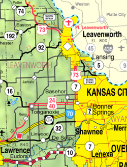
Basehor is a city in Leavenworth County, Kansas, United States which is included statistically in the Kansas City metropolitan area. As of the 2020 census, the population of the city was 6,896.

<span class="mw-page-title-main">Easton, Kansas</span> City in Kansas, United States

Easton is a city in Leavenworth County, Kansas, United States, and part of the Kansas City metropolitan area. As of the 2020 census, the population of the city was 213.

<span class="mw-page-title-main">Lansing, Kansas</span> City in Kansas, United States

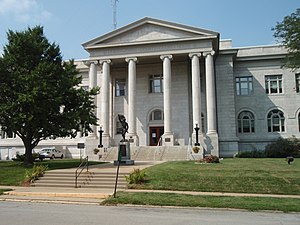
Lansing is a city in Leavenworth County, Kansas, United States. It is situated along the west side of the Missouri River and Kansas-Missouri state border. As of the 2020 census, the population of the city was 11,239. It is the second most populous city of Leavenworth County and is a part of the Kansas City metropolitan area. The Lansing Correctional Facility, which includes the state's main maximum-security prison, is located in Lansing.

<span class="mw-page-title-main">Linwood, Kansas</span> City in Kansas, United States

Linwood is a city in Leavenworth County, Kansas, United States, and part of the Kansas City metropolitan area. As of the 2020 census, the population of the city was 415. It is located along K-32 highway between Lawrence and Bonner Springs.

<span class="mw-page-title-main">Tonganoxie, Kansas</span> City in Kansas, United States

Tonganoxie is a city in Leavenworth County, Kansas, United States and is part of the Kansas City metropolitan area. As of the 2020 census, the population of the city was 5,573.

<span class="mw-page-title-main">Sherman Township, Leavenworth County, Kansas</span> Township in Kansas, United States

Sherman Township is one of ten townships in Leavenworth County, Kansas, United States. As of the 2010 census, its population was 2,657. Sherman contains two cities, Linwood and De Soto.

References

  1. 1 2 3 "QuickFacts; Leavenworth County, Kansas; Population, Census, 2020 & 2010". United States Census Bureau. Archived from the original on August 15, 2021. Retrieved August 15, 2021.
  2. "Annual Estimates of the Resident Population for Counties: April 1, 2020 to July 1, 2021" . Retrieved October 16, 2022.
  3. "Population Data and Maps | MARC".
  4. "Find a County". National Association of Counties. Retrieved June 7, 2011.
  5. Gannett, Henry (1905). The Origin of Certain Place Names in the United States. U.S. Government Printing Office. p.  183.
  6. "US Gazetteer files: 2010, 2000, and 1990". United States Census Bureau. February 12, 2011. Retrieved April 23, 2011.
  7. Big Stranger Creek Rogers, H.D., and Johnson, A. Keith. Kansas and Indian territory in The Atlas of the U.S. of North America, Canada, New Brunswick, Nova Scotia, Newfoundland, Mexico, Central America, Cuba and Jamaica. London: E. Stanford, 1857 (no scale). A historical reference showing the Kansas Territory including parts of Colorado. Shows the westward trails.
  8. Lower Kansas (Surf Your Watershed)
  9. "Annual Estimates of the Resident Population for Counties: April 1, 2020 to July 1, 2023". United States Census Bureau. Retrieved April 3, 2024.
  10. "U.S. Decennial Census". United States Census Bureau. Retrieved July 26, 2014.
  11. "Historical Census Browser". University of Virginia Library. Retrieved July 26, 2014.
  12. "Population of Counties by Decennial Census: 1900 to 1990". United States Census Bureau. Retrieved July 26, 2014.
  13. "Census 2000 PHC-T-4. Ranking Tables for Counties: 1990 and 2000" (PDF). United States Census Bureau. Archived (PDF) from the original on March 27, 2010. Retrieved July 26, 2014.
  14. "Dave Leip's Atlas of U.S. Presidential Elections".
  15. "Map of Wet and Dry Counties". Alcoholic Beverage Control, Kansas Department of Revenue. November 2006. Archived from the original on October 8, 2007. Retrieved December 28, 2007.
  16. Panetta, Grace (August 3, 2022). "14 of the 19 Kansas counties that rejected an anti-abortion amendment voted for Trump in 2020". Business Insider. Retrieved August 3, 2022.
  17. "2020 CENSUS - SCHOOL DISTRICT REFERENCE MAP: Leavenworth County, KS" (PDF). U.S. Census Bureau. Archived (PDF) from the original on July 6, 2022. Retrieved July 5, 2022. - Text list
  18. "Basehor-Linwood School District". www.usd458.org.
  19. USD 449, Easton (May 21, 2023). "Easton USD 449". www.easton449.org.{{cite web}}: CS1 maint: numeric names: authors list (link)
  20. "Tonganoxie USD 464". www.tong464.org.

Further reading

County
Maps

39°14′N95°02′W / 39.233°N 95.033°W / 39.233; -95.033