History
The Osage Indians had settled much of southeast Kansas over the course of the 1830s and 40s and sold land claims over the course of the 1860s to incoming American homesteaders and moved into Indian Territory (present-day Oklahoma) where they became settled farmers, selling their whole remaining claim to the United States government in 1870 for $1.25 an acre. [8]
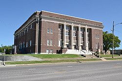
Independence was settled on land that was purchased from the Osage Nation in September 1869 by George A. Brown for the price of $50. [9] Brown originally called the townsite Colfax after Schuyler Colfax, vice president under President Ulysses S. Grant. [10] On August 21, 1869 a group of Oswego, Kansas men led by R. W. Wright settled there with the intent to make Independence the county seat. [11] E. E. Wilson and F D. Irwin opened the first store in October 1869, naming it Wilson & Irwin Groceries. [12] Independence was designated county seat in 1870. [13]
On April 17, 1930 the city was the first to use a permanent lighting system for an exhibition baseball game: it was held between the Independence Producers and House of David semi-professional baseball team of Benton Harbor, Michigan. The Independence team won with a score of 9 to 1 before a crowd of 1,700 spectators. [14]
Miss Able, a rhesus monkey, was born at Ralph Mitchell Zoo. Miss Able along with Miss Baker, a squirrel monkey, became the first monkeys that the United States used in its space program to fly in space; they returned alive on May 28, 1959. [15]
Geography
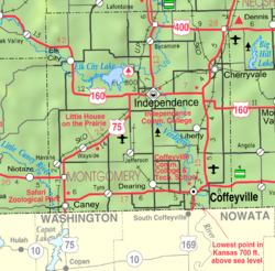
Independence is located along the Verdigris River just south of its confluence with the Elk River. According to the United States Census Bureau, the city has a total area of 7.75 square miles (20.07 km2), of which, 7.74 square miles (20.05 km2) is land and 0.01 square miles (0.03 km2) is water. [16]
Climate
Independence has a humid subtropical climate (Köppen Cfa) characterized by hot, humid and unpleasant summers, and chilly though extremely variable winters. Precipitation is heavy in summer due to frequent incursions of very moist air from the Gulf of Mexico: as much as 7.69 inches (195.3 mm) fell on May 27, 1984 and a maximum daily fall of 3.49 inches or 88.6 millimetres can be expected in an average calendar year. The wettest month has been June 2007 when 19.53 inches (496.1 mm) was reported, whereas July 1935 saw a mere 0.03 inches (0.8 mm). The winters are drier and cold, although temperatures in winter are very erratic, ranging from an average of four afternoons in the three winter months above 70 °F or 21.1 °C to an average of three mornings below 0 °F or −17.8 °C. Winters are much drier than the summer, with November 1986 and October 1952 seeing not even a trace of precipitation. [17]
Overall the wettest calendar year has been 1908 with 60.29 inches (1,531.4 mm) – although the incomplete year of 2007 likely had more than this – and the driest 1952 with only 18.27 inches (464.1 mm). [17] The hottest month has been July 1936 with an average of 88 °F (31.1 °C) and a mean maximum of 104.8 °F or 40.4 °C, while the coldest has been January 1979 with an average of 18.8 °F (−7.3 °C), a mean maximum of only 28.9 °F (−1.7 °C) and a mean minimum of 8.7 °F or −12.9 °C. The hottest monthly mean minimum was in July 2011 with a mean low as high as 74.3 °F or 23.5 °C.
| Climate data for Independence, Kansas, 1991–2020 normals, extremes 1893–present |
|---|
| Month | Jan | Feb | Mar | Apr | May | Jun | Jul | Aug | Sep | Oct | Nov | Dec | Year |
|---|
| Record high °F (°C) | 78
(26) | 88
(31) | 98
(37) | 101
(38) | 102
(39) | 109
(43) | 115
(46) | 116
(47) | 111
(44) | 99
(37) | 88
(31) | 80
(27) | 116
(47) |
|---|
| Mean maximum °F (°C) | 68.5
(20.3) | 73.4
(23.0) | 81.2
(27.3) | 85.6
(29.8) | 89.3
(31.8) | 93.6
(34.2) | 100.0
(37.8) | 100.3
(37.9) | 95.4
(35.2) | 87.3
(30.7) | 77.4
(25.2) | 68.7
(20.4) | 101.7
(38.7) |
|---|
| Mean daily maximum °F (°C) | 44.9
(7.2) | 50.0
(10.0) | 59.8
(15.4) | 69.1
(20.6) | 77.0
(25.0) | 85.6
(29.8) | 90.7
(32.6) | 90.3
(32.4) | 82.6
(28.1) | 71.6
(22.0) | 58.7
(14.8) | 47.5
(8.6) | 69.0
(20.5) |
|---|
| Daily mean °F (°C) | 33.8
(1.0) | 38.0
(3.3) | 47.5
(8.6) | 57.0
(13.9) | 66.3
(19.1) | 75.4
(24.1) | 80.2
(26.8) | 79.0
(26.1) | 70.9
(21.6) | 59.2
(15.1) | 47.0
(8.3) | 36.9
(2.7) | 57.6
(14.2) |
|---|
| Mean daily minimum °F (°C) | 22.7
(−5.2) | 26.0
(−3.3) | 35.2
(1.8) | 44.9
(7.2) | 55.5
(13.1) | 65.2
(18.4) | 69.6
(20.9) | 67.6
(19.8) | 59.2
(15.1) | 46.8
(8.2) | 35.2
(1.8) | 26.4
(−3.1) | 46.2
(7.9) |
|---|
| Mean minimum °F (°C) | 6.4
(−14.2) | 10.9
(−11.7) | 19.4
(−7.0) | 30.9
(−0.6) | 42.0
(5.6) | 54.8
(12.7) | 61.5
(16.4) | 58.7
(14.8) | 45.4
(7.4) | 31.6
(−0.2) | 20.8
(−6.2) | 10.5
(−11.9) | 2.4
(−16.4) |
|---|
| Record low °F (°C) | −19
(−28) | −23
(−31) | −5
(−21) | 15
(−9) | 28
(−2) | 42
(6) | 46
(8) | 43
(6) | 29
(−2) | 16
(−9) | 5
(−15) | −16
(−27) | −23
(−31) |
|---|
| Average precipitation inches (mm) | 1.44
(37) | 1.85
(47) | 2.88
(73) | 4.47
(114) | 6.76
(172) | 6.26
(159) | 4.29
(109) | 4.49
(114) | 4.12
(105) | 4.09
(104) | 2.40
(61) | 2.35
(60) | 45.40
(1,153) |
|---|
| Average snowfall inches (cm) | 2.2
(5.6) | 0.9
(2.3) | 1.9
(4.8) | 0.0
(0.0) | 0.0
(0.0) | 0.0
(0.0) | 0.0
(0.0) | 0.0
(0.0) | 0.0
(0.0) | 0.0
(0.0) | 0.3
(0.76) | 2.1
(5.3) | 7.4
(18.76) |
|---|
| Average precipitation days (≥ 0.01 in) | 5.8 | 5.7 | 8.3 | 9.7 | 11.7 | 9.3 | 8.0 | 7.4 | 7.1 | 7.7 | 6.3 | 6.3 | 93.3 |
|---|
| Average snowy days (≥ 0.1 in) | 1.9 | 0.8 | 0.7 | 0.0 | 0.0 | 0.0 | 0.0 | 0.0 | 0.0 | 0.0 | 0.3 | 1.2 | 4.9 |
|---|
| Source 1: NOAA [18] |
| Source 2: National Weather Service [19] |
Demographics
Historical population| Census | Pop. | Note | %± |
|---|
| 1870 | 435 | | — |
|---|
| 1880 | 2,915 | | 570.1% |
|---|
| 1890 | 3,127 | | 7.3% |
|---|
| 1900 | 4,851 | | 55.1% |
|---|
| 1910 | 10,480 | | 116.0% |
|---|
| 1920 | 11,920 | | 13.7% |
|---|
| 1930 | 12,782 | | 7.2% |
|---|
| 1940 | 11,565 | | −9.5% |
|---|
| 1950 | 11,335 | | −2.0% |
|---|
| 1960 | 11,222 | | −1.0% |
|---|
| 1970 | 10,347 | | −7.8% |
|---|
| 1980 | 10,598 | | 2.4% |
|---|
| 1990 | 9,942 | | −6.2% |
|---|
| 2000 | 9,846 | | −1.0% |
|---|
| 2010 | 9,483 | | −3.7% |
|---|
| 2020 | 8,548 | | −9.9% |
|---|
| 2023 (est.) | 8,315 | [20] | −2.7% |
|---|
|
2020 census
The 2020 United States census counted 8,548 people, 3,627 households, and 2,088 families in Independence. [22] [23] The population density was 1,114.6 per square mile (430.4/km2). There were 4,380 housing units at an average density of 571.1 per square mile (220.5/km2). [23] [24] The racial makeup was 79.12% (6,763) white or European American (76.13% non-Hispanic white), 5.5% (470) black or African-American, 1.66% (142) Native American or Alaska Native, 0.88% (75) Asian, 0.05% (4) Pacific Islander or Native Hawaiian, 2.56% (219) from other races, and 10.24% (875) from two or more races. [25] Hispanic or Latino of any race was 8.24% (704) of the population. [26]
Of the 3,627 households, 28.5% had children under the age of 18; 36.8% were married couples living together; 32.3% had a female householder with no spouse or partner present. 36.0% of households consisted of individuals and 16.3% had someone living alone who was 65 years of age or older. [23] The average household size was 2.1 and the average family size was 2.8. [27] The percent of those with a bachelor’s degree or higher was estimated to be 15.8% of the population. [28]
24.8% of the population was under the age of 18, 7.9% from 18 to 24, 23.8% from 25 to 44, 23.5% from 45 to 64, and 19.9% who were 65 years of age or older. The median age was 38.9 years. For every 100 females, there were 109.2 males. [23] For every 100 females ages 18 and older, there were 111.3 males. [23]
The 2016-2020 5-year American Community Survey estimates show that the median household income was $38,963 (with a margin of error of +/- $4,924) and the median family income was $50,299 (+/- $5,851). [29] Males had a median income of $31,436 (+/- $4,208) versus $23,707 (+/- $4,084) for females. The median income for those above 16 years old was $27,652 (+/- $3,039). [30] Approximately, 14.7% of families and 21.0% of the population were below the poverty line, including 34.3% of those under the age of 18 and 12.0% of those ages 65 or over. [31] [32]
2010 census
As of the census [33] of 2010, there were 9,483 people, 3,950 households, and 2,430 families living in the city. [34] The population density was 1,225.2 inhabitants per square mile (473.1/km2). There were 4,528 housing units at an average density of 585.0 per square mile (225.9/km2). The racial makeup of the city was 84.2% White, 6.5% African American, 1.6% Native American, 0.9% Asian, 2.3% from other races, and 4.5% from two or more races. Hispanic or Latino of any race were 6.5% of the population.
There were 3,950 households, of which 33.0% had children under the age of 18 living with them, 40.9% were married couples living together, 14.9% had a female householder with no husband present, 5.7% had a male householder with no wife present, and 38.5% were non-families. 33.0% of all households were made up of individuals, and 14.8% had someone living alone who was 65 years of age or older. The average household size was 2.35 and the average family size was 2.95.
The median age in the city was 36.9 years. 26% of residents were under the age of 18; 8.6% were between the ages of 18 and 24; 24.5% were from 25 to 44; 24.9% were from 45 to 64; and 15.9% were 65 years of age or older. The gender makeup of the city was 48.4% male and 51.6% female.
2000 census
As of the census [35] of 2000, there were 9,846 people, 4,149 households, and 2,609 families living in the city. The population density was 1,979.4 inhabitants per square mile (764.3/km2). There were 4,747 housing units at an average density of 954.3 per square mile (368.5/km2). The racial makeup of the city was 87.00% White, 7.17% African American, 1.16% Native American, 0.62% Asian, 0.01% Pacific Islander, 1.10% from other races, and 2.95% from two or more races. Hispanic or Latino of any race were 3.84% of the population.
There were 4,149 households, out of which 30.2% had children under the age of 18 living with them, 46.8% were married couples living together, 12.3% had a female householder with no husband present, and 37.1% were non-families. 32.7% of all households were made up of individuals, and 15.2% had someone living alone who was 65 years of age or older. The average household size was 2.32, and the average family size was 2.93.
In the city, the population was spread out, with 25.7% under the age of 18, 8.9% from 18 to 24, 26.1% from 25 to 44, 21.3% from 45 to 64, and 18.0% who were 65 years of age or older. The median age was 37 years. For every 100 females, there were 89.9 males. For every 100 females age 18 and over, there were 84.9 males.
The median income for a household in the city was $29,574, and the median income for a family was $37,134. Males had a median income of $26,552 versus $20,017 for females. The per capita income for the city was $15,496. About 11.4% of families and 13.1% of the population were below the poverty line, including 18.7% of those under age 18 and 13.2% of those age 65 or over.
This page is based on this
Wikipedia article Text is available under the
CC BY-SA 4.0 license; additional terms may apply.
Images, videos and audio are available under their respective licenses.