Cloud County, Kansas

Last updated

Cloud County
Cloud County Court House.JPG
Cloud County Courthouse in Concordia (2013)
Map of Kansas highlighting Cloud County.svg
Location within the U.S. state of Kansas
Kansas in United States.svg
Kansas's location within the U.S.
Coordinates: 39°29′N97°39′W / 39.483°N 97.650°W / 39.483; -97.650
CountryFlag of the United States.svg United States
StateFlag of Kansas.svg  Kansas
FoundedMarch 27, 1867
Named for William F. Cloud
Seat Concordia
Largest cityConcordia
Area
  Total718 sq mi (1,860 km2)
  Land715 sq mi (1,850 km2)
  Water2.6 sq mi (7 km2)  0.4%
Population
 (2020) [1]
  Total9,032
  Density12.6/sq mi (4.9/km2)
Time zone UTC−6 (Central)
  Summer (DST) UTC−5 (CDT)
Area code 785
Congressional district 1st
Website cloudcountyks.org

Cloud County is a county located in the U.S. state of Kansas. Its county seat and most populous city is Concordia. [2] As of the 2020 census, the county population was 9,032. [1] The county was named after William Cloud, an officer in the American Civil War.

Contents

History

1915 Railroad Map of Cloud County Stouffer's Railroad Map of Kansas 1915-1918 Cloud County.png
1915 Railroad Map of Cloud County

Early history

For many millennia, the Great Plains of North America was inhabited by nomadic Native Americans. From the 16th century to 18th century, the Kingdom of France claimed ownership of large parts of North America. In 1762, after the French and Indian War, France secretly ceded New France to Spain, per the Treaty of Fontainebleau.

19th century

In 1802, Spain returned most of the land to France, but keeping title to about 7,500 square miles. In 1803, most of the land for modern day Kansas was acquired by the United States from France as part of the 828,000 square mile Louisiana Purchase for 2.83 cents per acre.

In 1854, the Kansas Territory was organized, then in 1861 Kansas became the 34th U.S. state. In 1867, Cloud County was established.

Cloud county was originally named Shirley County, but civic leaders feared that sounded too much like the name of a prostitute. [3] It was then renamed "Cloud" county in honor of Colonel William F. Cloud. [4]

Cloud County was formed from the existing Washington County, Kansas in a joint convention with Republic and Cloud counties. The county was legally organized on September 6, 1866, with Elk Creek designated as the temporary county seat. [5]

In 1887, Atchison, Topeka and Santa Fe Railway built a branch line from Neva (3 miles west of Strong City) to Superior, Nebraska. This branch line connected Strong City, Neva, Rockland, Diamond Springs, Burdick, Lost Springs, Jacobs, Hope, Navarre, Enterprise, Abilene, Talmage, Manchester, Longford, Oak Hill, Miltonvale, Aurora, Huscher, Concordia, Kackley, Courtland, Webber, Superior. At some point, the line from Neva to Lost Springs was pulled but the right of way has not been abandoned. This branch line was originally called "Strong City and Superior line" but later the name was shortened to the "Strong City line". In 1996, the Atchison, Topeka and Santa Fe Railway merged with Burlington Northern Railroad and renamed to the current BNSF Railway. Most locals still refer to this railroad as the "Santa Fe".

Geography

According to the U.S. Census Bureau, the county has a total area of 718 square miles (1,860 km2), of which 715 square miles (1,850 km2) is land and 2.6 square miles (6.7 km2) (0.4%) is water. [6]

Geographic features

The Republican River passes through the county, entering from Republic County to the north and exiting to Clay County to the east. The Solomon River traverses the southwestern portion of the county, going from Mitchell County to Ottawa County. Jamestown Lake lies partially in the northwestern part of the county and partially in southwestern Republic county.

Major highways

Cloud County is bisected from north to south by U.S. Route 81, which runs through the town of Concordia and connects north to Belleville, Kansas or south to Salina, Kansas. The southern part of the county also has U.S. Route 24, connecting Clay Center, Kansas from the east and Beloit, Kansas to the west.

There are four other state highways in the county: K-9, K-28, K-189, and K-194.

Adjacent counties

Demographics

Population pyramid based on 2000 census age data USA Cloud County, Kansas age pyramid.svg
Population pyramid based on 2000 census age data
Historical population
CensusPop.Note
1870 2,323
1880 15,343560.5%
1890 19,29525.8%
1900 18,071−6.3%
1910 18,3881.8%
1920 17,714−3.7%
1930 18,0061.6%
1940 17,247−4.2%
1950 16,104−6.6%
1960 14,407−10.5%
1970 13,466−6.5%
1980 12,494−7.2%
1990 11,023−11.8%
2000 10,268−6.8%
2010 9,533−7.2%
2020 9,032−5.3%
2023 (est.)8,854 [7] −2.0%
U.S. Decennial Census [8]
1790–1960 [9] 1900–1990 [10]
1990–2000 [11] 2010–2020 [1]

As of the 2000 census, [12] there were 10,268 people, 4,163 households, and 2,697 families residing in the county. The population density was 14 people per square mile (5.4 people/km2). There were 4,838 housing units at an average density of 7 per square mile (2.7/km2). The racial makeup of the county was 98.30% White, 0.34% Black or African American, 0.25% Native American, 0.25% Asian, 0.13% from other races, and 0.73% from two or more races. Hispanic or Latino of any race were 0.60% of the population.

There were 4,163 households, out of which 27.10% had children under the age of 18 living with them, 55.10% were married couples living together, 6.60% had a female householder with no husband present, and 35.20% were non-families. 30.80% of all households were made up of individuals, and 15.90% had someone living alone who was 65 years of age or older. The average household size was 2.31 and the average family size was 2.89.

In the county, the population was spread out, with 22.40% under the age of 18, 10.40% from 18 to 24, 21.90% from 25 to 44, 22.20% from 45 to 64, and 23.20% who were 65 years of age or older. The median age was 41 years. For every 100 females there were 90.60 males. For every 100 females age 18 and over, there were 86.60 males.

The median income for a household in the county was $31,758, and the median income for a family was $39,745. Males had a median income of $27,166 versus $20,114 for females. The per capita income for the county was $17,536. About 6.40% of families and 10.80% of the population were below the poverty line, including 12.10% of those under age 18 and 8.70% of those age 65 or over.

Government

Presidential elections

Cloud County is a Republican Stronghold. The Last democrat to carry this county was Jimmy Carter in 1976.

Presidential election results
United States presidential election results for Cloud County, Kansas [13]
Year Republican Democratic Third party
No.%No.%No.%
2020 3,24276.05%92021.58%1012.37%
2016 2,91973.81%76119.24%2756.95%
2012 2,95472.79%97424.00%1303.20%
2008 3,12170.12%1,23327.70%972.18%
2004 3,22171.53%1,21026.87%721.60%
2000 2,91864.80%1,31429.18%2716.02%
1996 2,74354.66%1,61532.18%66013.15%
1992 2,13139.12%1,72031.57%1,59729.31%
1988 3,04359.34%2,02239.43%631.23%
1984 3,86066.43%1,88032.35%711.22%
1980 3,58161.56%1,79330.82%4437.62%
1976 2,95448.74%2,97649.10%1312.16%
1972 3,83266.38%1,80631.28%1352.34%
1968 3,28256.17%2,13236.49%4297.34%
1964 2,68044.35%3,31454.84%490.81%
1960 4,04560.58%2,60739.04%250.37%
1956 4,46668.61%2,00830.85%350.54%
1952 5,58075.23%1,79324.17%440.59%
1948 4,01856.16%2,89140.41%2463.44%
1944 4,37763.67%2,39134.78%1071.56%
1940 5,27560.44%3,32738.12%1261.44%
1936 4,20847.90%4,54651.75%310.35%
1932 3,12039.94%4,45757.05%2353.01%
1928 5,28668.25%2,37630.68%831.07%
1924 4,34262.57%1,23817.84%1,35919.58%
1920 4,09069.82%1,53426.19%2343.99%
1916 2,87039.92%3,83753.37%4836.72%
1912 89921.79%1,65840.18%1,56938.03%
1908 2,17052.24%1,66340.03%3217.73%
1904 2,47067.56%62617.12%56015.32%
1900 2,31551.87%2,04545.82%1032.31%
1896 1,71844.13%2,12954.69%461.18%
1892 1,91544.98%00.00%2,34255.02%
1888 2,54259.55%1,05224.64%67515.81%

Laws

Following amendment to the Kansas Constitution in 1986, Cloud County remained a prohibition, or "dry", county until 1998, when voters approved the sale of alcoholic liquor by the individual drink with a 30 percent food sales requirement. [14]

Education

Colleges

Historic

Unified school districts

Communities

2005 KDOT Map of Cloud County (map legend) Map of Cloud Co, Ks, USA.png
2005 KDOT Map of Cloud County (map legend)

‡ means a community has portions in an adjacent county or counties. † means a community is designated a Census-Designated Place (CDP) by the United States Census Bureau.

Cities

Unincorporated communities

Ghost towns

Townships

Cloud County is divided into eighteen townships. The city of Concordia is considered governmentally independent and is excluded from the census figures for the townships. In the following table, the population center is the largest city (or cities) included in that township's population total, if it is of a significant size.

Township FIPS Population
center
PopulationPopulation
density
/km2 (/sq mi)
Land area
km2 (sq mi)
Water area
km2 (sq mi)
Water %Geographic coordinates
Arion022751051 (3)94 (36)0 (0)0.06% 39°28′28″N97°44′42″W / 39.47444°N 97.74500°W / 39.47444; -97.74500
Aurora034501692 (5)94 (36)0 (0)0.03% 39°26′27″N97°32′2″W / 39.44083°N 97.53389°W / 39.44083; -97.53389
Buffalo091001191 (3)112 (43)1 (0)0.46% 39°35′12″N97°45′13″W / 39.58667°N 97.75361°W / 39.58667; -97.75361
Center116251721 (3)141 (54)0 (0)0% 39°26′51″N97°38′45″W / 39.44750°N 97.64583°W / 39.44750; -97.64583
Colfax14775491 (1)93 (36)0 (0)0.05% 39°26′6″N97°25′19″W / 39.43500°N 97.42194°W / 39.43500; -97.42194
Elk2015084512 (30)72 (28)1 (0)1.08% 39°35′51″N97°24′16″W / 39.59750°N 97.40444°W / 39.59750; -97.40444
Grant275254795 (14)92 (35)2 (1)1.75% 39°36′6″N97°52′7″W / 39.60167°N 97.86861°W / 39.60167; -97.86861
Lawrence388751462 (4)93 (36)1 (0)1.22% 39°36′18″N97°32′41″W / 39.60500°N 97.54472°W / 39.60500; -97.54472
Lincoln405253786 (16)61 (24)1 (0)1.21% 39°33′20″N97°39′5″W / 39.55556°N 97.65139°W / 39.55556; -97.65139
Lyon434251031 (2)142 (55)0 (0)0.02% 39°22′2″N97°46′20″W / 39.36722°N 97.77222°W / 39.36722; -97.77222
Meredith45925771 (2)94 (36)0 (0)0.03% 39°21′1″N97°38′53″W / 39.35028°N 97.64806°W / 39.35028; -97.64806
Nelson496001372 (4)91 (35)0 (0)0% 39°30′55″N97°31′36″W / 39.51528°N 97.52667°W / 39.51528; -97.52667
Oakland51750521 (1)93 (36)0 (0)0.15% 39°21′44″N97°31′44″W / 39.36222°N 97.52889°W / 39.36222; -97.52889
Shirley653751782 (4)110 (42)1 (0)0.60% 39°32′47″N97°26′5″W / 39.54639°N 97.43472°W / 39.54639; -97.43472
Sibley654251782 (5)92 (35)1 (1)1.45% 39°36′54″N97°42′5″W / 39.61500°N 97.70139°W / 39.61500; -97.70139
Solomon662506645 (12)141 (54)0 (0)0% 39°21′49″N97°51′34″W / 39.36361°N 97.85944°W / 39.36361; -97.85944
Starr680506537 (18)92 (36)0 (0)0.21% 39°20′52″N97°26′42″W / 39.34778°N 97.44500°W / 39.34778; -97.44500
Summit69050500 (1)139 (54)0 (0)0% 39°30′11″N97°51′59″W / 39.50306°N 97.86639°W / 39.50306; -97.86639
Sources: "Census 2000 U.S. Gazetteer Files". U.S. Census Bureau, Geography Division. Archived from the original on August 2, 2002.

Notable people

Frank Carlson was the 30th Governor of Kansas. He called Concordia his home, and the Frank Carlson Library is named in his honor. Frankcarlson(r-ks).jpg
Frank Carlson was the 30th Governor of Kansas. He called Concordia his home, and the Frank Carlson Library is named in his honor.
See List of people from Cloud County, Kansas

Charles H. Blosser was an aviator who was awarded the Kansas Governor's Aviation Honors Award and was inducted into the Kansas Aviation Hall of Fame in 1990. At one time, he was the oldest living licensed pilot in the United States. [15] [16]

Napoleon Bonaparte Brown was a soldier, businessman, politician, and resident of Kansas and Missouri in the late 19th and early 20th centuries. [17] He is most known as the namesake and builder of the Brown Grand Theatre in Concordia, Kansas, a majestic opera house completed in 1907 and listed on the National Register of Historic Places. The theater has been called "the most elegant theater between Kansas City and Denver." [17]

Frank Carlson was an American politician who served as the 30th Governor of Kansas and United States Representative and United States Senator from Kansas. He called Concordia his home. [18]

Larry Hartshorn was a former NFL Offensive Guard who played for the Chicago Cardinals in 1955 and 1957. He later played in the Canadian Football League with the Calgary Stampeders in 1958. After his years in professional football, Hartshorn moved to Concordia to become a teacher and coach for 33 years at Concordia Junior-Senior High School, where he coached Keith Christensen. Hartshorn began the wrestling program in 1966, running it as head coach from 1966 to 1974. He continued to serve in various coaching and education capacities until his retirement.

Ernest C. Quigley was a basketball referee and as an umpire in Major League Baseball. He also worked as an American football coach and official. Quigley was raised in Concordia, Kansas where he was a prominent member of the high school football team in the 1890s. [19] In 1944 he became the athletic director at the University of Kansas. [20]

Cloud County has also been listed as one of the locations for Smallville in the Superman story line.

See also

Community information for Kansas

Related Research Articles

<span class="mw-page-title-main">Clay County, Kansas</span> County in Kansas, United States

Clay County is a county located in the U.S. state of Kansas. Its county seat and most populous city is Clay Center. As of the 2020 census, the county population was 8,117. The county was named for Henry Clay, an influential U.S. Senator from Kentucky.

<span class="mw-page-title-main">Wallace County, Kansas</span> County in Kansas, United States

Wallace County is a county located in the U.S. state of Kansas. Its county seat is Sharon Springs. As of the 2020 census, the county population was 1,512, making it the second-least populous county in Kansas. The county was created in 1868 and named in honor of Brigadier General W.H.L. Wallace, who had been mortally wounded in combat in the Battle of Shiloh. Wallace County is home to Mount Sunflower, the highest point in Kansas at 4,039 feet. Mount Sunflower is located approximately 15 miles (24 km) north-northwest of Weskan, less than one mile (1.6 km) from the Colorado state line. It is one of four Kansas counties to use the Mountain Time Zone rather than the Central Time Zone like the remainder of Kansas.

<span class="mw-page-title-main">Stanton County, Kansas</span> County in Kansas, United States

Stanton County is a county located in the U.S. state of Kansas. Its county seat is Johnson City. As of the 2020 census, the county population was 2,084. It was named for Edwin Stanton, the U.S. Secretary of War during most of the American Civil War.

<span class="mw-page-title-main">Rooks County, Kansas</span> County in Kansas, United States

Rooks County is a county located in the U.S. state of Kansas. Its county seat is Stockton, and its largest city is Plainville. As of the 2020 census, the county population was 4,919. The county was named for John Rooks, a private in Company I of the 11th Kansas Cavalry Regiment, who died at the Battle of Prairie Grove during the American Civil War.

<span class="mw-page-title-main">Republic County, Kansas</span> County in Kansas, United States

Republic County is a county located in the state of Kansas, south from the Nebraska state line. Its county seat and largest city is Belleville. As of the 2020 census, the county population was 4,674. The county was named after the Republican River.

<span class="mw-page-title-main">Ottawa County, Kansas</span> County in Kansas, United States

Ottawa County is a county located in the U.S. state of Kansas. Its county seat and largest city is Minneapolis. As of the 2020 census, the county population was 5,735. The county was named after the Odawa tribe.

<span class="mw-page-title-main">Morris County, Kansas</span> County in Kansas, United States

Morris County is a county located in the U.S. state of Kansas. Its county seat and largest city is Council Grove. As of the 2020 census, the county population was 5,386. The county was named for Thomas Morris, a U.S. Senator from Ohio and anti-slavery advocate.

<span class="mw-page-title-main">Mitchell County, Kansas</span> County in Kansas, United States

Mitchell County is a county located in the U.S. state of Kansas. Its county seat and largest city is Beloit. As of the 2020 census, the county population was 5,796. The county was named for William Mitchell.

<span class="mw-page-title-main">Linn County, Kansas</span> County in Kansas, United States

Linn County is a county in the U.S. state of Kansas, located in along the eastern edge of Kansas, and is part of the Kansas City metropolitan area. Its county seat is Mound City, and its most populous city is Pleasanton. As of the 2020 census, the county population was 9,591. The county was named for Lewis Linn, a U.S. Senator from Missouri.

<span class="mw-page-title-main">Jewell County, Kansas</span> County in Kansas, United States

Jewell County is a county located in the U.S. state of Kansas. Its county seat and most populous city is Mankato. As of the 2020 census, the county population was 2,932. The county was named for Lewis Jewell, a lieutenant colonel of the 6th Regiment Kansas Volunteer Cavalry.

<span class="mw-page-title-main">Elk County, Kansas</span> County in Kansas, United States

Elk County is a county located in the U.S. state of Kansas. Its county seat and most populous city is Howard. As of the 2020 census, the county population was 2,483. The county was named for the Elk River.

<span class="mw-page-title-main">Dickinson County, Kansas</span> County in Kansas, United States

Dickinson County is a county in Central Kansas. Its county seat and most populous city is Abilene. As of the 2020 census, the county population was 18,402. The county was named in honor of Daniel Dickinson, a U.S. Senator from New York that was a Kansas statehood advocate.

<span class="mw-page-title-main">Cherokee County, Kansas</span> County in Kansas, United States

Cherokee County is a U.S. county located in Southeast Kansas. Its county seat is Columbus, and its most populous city is Baxter Springs. As of the 2020 census, the county population was 19,362. The county was named for the Cherokee tribe.

<span class="mw-page-title-main">Chase County, Kansas</span> County in Kansas, United States

Chase County is a county located in the U.S. state of Kansas. Its county seat and most populous city is Cottonwood Falls. As of the 2020 census, the county population was 2,572. The county was named for Salmon Chase, a U.S. Senator from Ohio that was a Kansas statehood advocate.

<span class="mw-page-title-main">Strong City, Kansas</span> City in Chase County, Kansas

Strong City is a city in Chase County, Kansas, United States. Originally known as Cottonwood Station, in 1881 it was renamed Strong City after William Barstow Strong, then vice-president and general manager, and later president of the Atchison, Topeka and Santa Fe Railway. As of the 2020 census, the population of the city was 386. It is located along U.S. Route 50 highway.

<span class="mw-page-title-main">Concordia, Kansas</span> City in Cloud County, Kansas

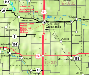
Concordia is a city in and the county seat of Cloud County, Kansas, United States. It is located along the Republican River in the Smoky Hills region of the Great Plains in North Central Kansas. As of the 2020 census, the population of the city was 5,111. Concordia is home of the Cloud County Community College and the Nazareth Convent and Academy.

<span class="mw-page-title-main">Miltonvale, Kansas</span> City in Cloud County, Kansas

Miltonvale is a city in Cloud County, Kansas, United States. As of the 2020 census, the population of the city was 440.

<span class="mw-page-title-main">Lost Springs, Kansas</span> City in Marion County, Kansas

Lost Springs is a city in Marion County, Kansas, United States. As of the 2020 census, the population of the city was 55. The city was named for a nearby lost spring that was a camping spot along the 19th century Santa Fe Trail. It is located south of Herington, about 0.6 miles west of the intersection of U.S. Route 77 highway and 340th Street next to the Union Pacific Railroad.

Huscher is an unincorporated community in Cloud County, Kansas, United States.

<span class="mw-page-title-main">Burdick, Kansas</span> Unincorporated community in Morris County, Kansas

Burdick is an unincorporated community in Morris County, Kansas, United States. It was named after Ms. Burdick, the sweetheart of a Santa Fe Railroad official in 1887. As of the 2020 census, the population of the community and nearby areas was 62. It is located southeast of Herington, about 5.6 miles (9.0 km) east of the intersection of U.S. Route 77 highway and 340th Street, or about 6.5 miles (10.5 km) east of Lost Springs.

References

  1. 1 2 3 "QuickFacts; Cloud County, Kansas; Population, Census, 2020 & 2010". United States Census Bureau. Archived from the original on August 15, 2021. Retrieved August 15, 2021.
  2. "Find a County". National Association of Counties. Archived from the original on May 31, 2011. Retrieved June 7, 2011.
  3. Brackman, Barbara (1997). Kansas Trivia. Thomas Nelson Inc. p. 21. ISBN   9781418553814.
  4. Kansas Skyways Archived February 23, 2009, at the Wayback Machine "Cloud County History"
  5. History of the State of Kansas by William G. Cutler, Kansas Collection of Books
  6. "US Gazetteer files: 2010, 2000, and 1990". United States Census Bureau. February 1, 2011. Retrieved April 23, 2011.
  7. "Annual Estimates of the Resident Population for Counties: April 1, 2020 to July 1, 2023". United States Census Bureau. Retrieved April 3, 2024.
  8. "U.S. Decennial Census". United States Census Bureau. Retrieved July 22, 2014.
  9. "Historical Census Browser". University of Virginia Library. Archived from the original on August 11, 2012. Retrieved July 22, 2014.
  10. "Population of Counties by Decennial Census: 1900 to 1990". United States Census Bureau. Retrieved July 22, 2014.
  11. "Census 2000 PHC-T-4. Ranking Tables for Counties: 1990 and 2000" (PDF). United States Census Bureau. Archived (PDF) from the original on March 27, 2010. Retrieved July 22, 2014.
  12. "U.S. Census website". United States Census Bureau . Retrieved January 31, 2008.
  13. "Dave Leip's Atlas of U.S. Presidential Elections".
  14. "Map of Wet and Dry Counties". Alcoholic Beverage Control, Kansas Department of Revenue. November 2006. Archived from the original on October 8, 2007. Retrieved December 26, 2007.
  15. "Wings Over Kansas". Archived from the original on September 30, 2011. Retrieved March 30, 2012.
  16. Unruh, Tim (May 31, 2010). "Flood of Memories". Salina Journal. Archived from the original on July 4, 2010. Retrieved March 28, 2012.
  17. 1 2 Moran, Jerry. "Historic Performing Theatre – The Brown Grand Theatre". The American Folklife Center at the Library of Congress. Retrieved February 29, 2008.
  18. "Biographical Directory of the United States Congress". United States Congress . Retrieved March 30, 2012.
  19. It Takes People to Make a Town by Janet Pease Emery, p. 101, 1971
  20. Kansas State Historical Society Archived July 3, 2010, at the Wayback Machine "E.C. (Ernie) Quigley"

Further reading

County
Maps