Kansas is a state in the Midwestern region of the United States. Kansas is a landlocked state which borders Nebraska to the north; Missouri to the east; Oklahoma to the south; and Colorado to the west. Kansas is named after the Kansas River, in turn named after the Kansa people. Its capital is Topeka, and its most populous city is Wichita, however the largest urban area is the bi-state Kansas City, MO–KS metropolitan area.

Wyandotte County is a county in the U.S. state of Kansas. Its county seat and most populous city is Kansas City, with which it shares a unified government. As of the 2020 census, the population was 169,245, making it Kansas's fourth-most populous county. The county was named after the Wyandot tribe.

Woodson County is a county located in the U.S. state of Kansas. Its county seat is Yates Center. As of the 2020 census, the county population was 3,115. The county was named after Daniel Woodson, a five-time acting governor of the Kansas Territory.

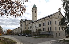
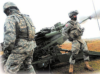
Riley County is a county located in the U.S. state of Kansas. Its county seat and largest city is Manhattan. As of the 2020 census, the population was 71,959. The county was named after Bennet Riley, the 7th governor of California, and a Mexican–American War hero. Riley County is home to Fort Riley and Kansas State University.

Neosho County is a county located in Southeast Kansas. Its county seat is Erie. As of the 2020 census, the county population was 15,904. The county was named for the Neosho River, which passes through the county.

Linn County is a county in the U.S. state of Kansas, located in along the eastern edge of Kansas, and is part of the Kansas City metropolitan area. Its county seat is Mound City, and its most populous city is Pleasanton. As of the 2020 census, the county population was 9,591. The county was named for Lewis Linn, a U.S. Senator from Missouri.

Labette County is a county located in Southeast Kansas. Its county seat is Oswego, and its most populous city is Parsons. As of the 2020 census, the county population was 20,184. The county was named after LaBette creek, the second-largest creek in the county, which runs roughly NNW-SSE from near Parsons to Chetopa. The creek in turn was named after French-Canadian fur trapper Pierre LaBette who had moved to the area, living along the Neosho River, and marrying into the Osage tribe in the 1830s and 1840s.

Geary County is a county located in the U.S. state of Kansas. Its county seat and most populous city is Junction City. As of the 2020 census, the county population was 36,739. The county is named in honor of John Geary, the first mayor of San Francisco, a governor of the Kansas Territory, and the 16th governor of Pennsylvania.

Chase County is a county located in the U.S. state of Kansas. Its county seat and most populous city is Cottonwood Falls. As of the 2020 census, the county population was 2,572. The county was named for Salmon Chase, a U.S. Senator from Ohio that was a Kansas statehood advocate.

Bourbon County is a county located in Southeast Kansas. Its county seat and most populous city is Fort Scott. As of the 2020 census, the county population was 14,360. The county was named after Bourbon County, Kentucky, the former home of many early settlers.

Allen County is a county located in the southeast portion of the U.S. state of Kansas. Its county seat and most populous city is Iola. As of the 2020 census, the population was 12,526. The county was named for William Allen, a U.S. Senator from Ohio and prominent supporter of westward expansion.

El Paso County is the most populous county located in the U.S. state of Colorado. The 2020 Census recorded its population as 730,395, surpassing the City and County of Denver. The county seat is Colorado Springs, the second most populous city in Colorado. El Paso County is included in the Colorado Springs, Colorado, Metropolitan Statistical Area.

Chanute is a city in Neosho County, Kansas, United States. Founded on January 1, 1873, it was named after railroad engineer and aviation pioneer Octave Chanute. As of the 2020 census, the population of the city was 8,722. Chanute is home of Neosho County Community College.

Neosho is the most populous city in Newton County, Missouri, United States, which it serves as the county seat. With a population of 12,590 as of the 2020 census, the city is a part of the Joplin, Missouri Metropolitan Statistical Area, a region with an estimated 176,849 (2011) residents. Neosho lies on the western edge of the Ozarks, in the far southwest of the state.
Fort Lewis is a United States Army base located 9.1 miles (14.6 km) south-southwest of Tacoma, Washington. Fort Lewis was merged with McChord Air Force Base on February 1, 2010, to form Joint Base Lewis–McChord.

The Dallas–Fort Worth metroplex, officially designated Dallas–Fort Worth–Arlington by the U.S. Office of Management and Budget, is the most populous metropolitan statistical area in the U.S. state of Texas and the Southern United States, encompassing 11 counties. Its historically dominant core cities are Dallas and Fort Worth. It is the economic and cultural hub of North Texas. Residents of the area also refer to it as DFW, or the Metroplex. The Dallas–Fort Worth–Arlington metropolitan statistical area's population was 7,637,387 according to the U.S. Census Bureau's 2020 census, making it the most populous metropolitan area in both Texas and the Southern United States, the fourth-largest in the U.S. and the tenth-largest in the Americas. In 2016, the Dallas–Fort Worth metroplex had the highest annual population growth in the United States.

Cedar Hill is a city in Dallas and Ellis counties in the U.S. state of Texas. It is located approximately 16 miles (26 km) southwest of downtown Dallas and is situated along the eastern shore of Joe Pool Lake and Cedar Hill State Park. Per the 2020 United States census, the population was 49,148. Cedar Hill is a suburb of the city of Dallas and is part of the Best Southwest area, which includes the nearby cities of DeSoto, Duncanville, and Lancaster.
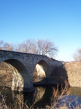
Cottonwood River is one of the principal tributaries of the Neosho River in central Kansas of the United States.

South Mound is an unincorporated community in Neosho County, Kansas, United States. As of the 2020 census, the population of the community and nearby areas was 27.