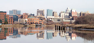
Wilmington is the largest city in the U.S. state of Delaware. The city was built on the site of Fort Christina, the first Swedish settlement in North America. It lies at the confluence of the Christina River and Brandywine Creek, near where the Christina flows into the Delaware River. It is the county seat of New Castle County and one of the major cities in the Delaware Valley metropolitan area. Wilmington was named by Proprietor Thomas Penn after his friend Spencer Compton, Earl of Wilmington, who was prime minister during the reign of George II of Great Britain.
Winchester is a home rule-class city in and the county seat of Clark County, Kentucky, United States. The population was 18,368 at the 2010 census. It is part of the Lexington-Fayette, KY Metropolitan Statistical Area. Winchester is located roughly halfway between Lexington and Mt. Sterling.

Nicholasville is a home rule city in and the county seat of Jessamine County, Kentucky. The population was 31,490 during the 2020 U.S. census, making Nicholasville the 10th-largest settlement in the state.

Ashland Park is a historic early 20th century neighborhood in Lexington, Kentucky, United States. It was named after Ashland, the estate of Kentucky statesman Henry Clay which is located in the eastern portion of the neighborhood. The 600-acre (2.4 km2) development was designed by the famous landscape architecture firm the Olmsted Brothers of Massachusetts. The neighborhood belongs to the National Register of Historic Places.
Man o' War Boulevard, named after the racehorse Man o' War, is an almost 17-mile (27 km) urban arterial, circling Lexington, Kentucky to its south. Its western terminus is at US 60 / Keeneland Boulevard at Keeneland Race Course's main entrance, from which the highway heads southeast, intersecting with US 68, US 27, and other roads. It then turns east and northeast, intersecting KY 1974, US 25/US 421, and I-75, before ending at US 60 at Brighton. The majority of the road is a four-lane divided highway with curbs and sidewalks maintained by the Lexington-Fayette Urban County Government, but the 1.429-mile (2.300 km) portion east of I-75 is maintained by the Kentucky Transportation Cabinet as Supplemental Road Kentucky Route 1425, and only carries two lanes.

U.S. Route 1 (US 1) is a major north–south U.S. Route, extending from Key West, Florida, in the south to Fort Kent, Maine, at the Canada–United States border in the north. In the U.S. state of Pennsylvania, US 1 runs for 81 miles (130 km) from the Maryland state line near Nottingham northeast to the New Jersey state line at the Delaware River in Morrisville, through the southeastern portion of the state. The route runs southwest to northeast and serves as a major arterial road through the city of Philadelphia and for many of the suburbs in the Delaware Valley metropolitan area. South of Philadelphia, the road mostly follows the alignment of the Baltimore Pike. Within Philadelphia, it mostly follows Roosevelt Boulevard. North of Philadelphia, US 1 parallels the route of the Lincoln Highway. Several portions of US 1 in Pennsylvania are freeways, including from near the Maryland state line to Kennett Square, the bypass of Media, the concurrency with Interstate 76 and the Roosevelt Expressway in Philadelphia, and between Bensalem Township and the New Jersey state line.
Forest Park is a region of Northwest Baltimore, Maryland located west of Reisterstown Road, south of Northern Parkway, and east of the Baltimore City/County line. In Baltimore, the region is referred to by locals simply as "Forest Park" and includes the neighborhoods of Ashburton, Callaway-Garrison, Central Forest Park, Dolfield, Dorchester, East Arlington, Forest Park, Grove Park, Hanlon Longwood, Howard Park, Garwyn Oaks, Purnell, West Arlington, West Forest Park, and Windsor Hills.
Burley Park is a neighborhood in southwestern Lexington, Kentucky, United States. It is named for the large number of tobacco warehouses that were once located in the neighborhood. Its boundaries are Waller Avenue and Mason Headley Road to the south, east of Beacon Hill Drive/ Summerville Drive/ Addison Park to the west, Red Mile Road and Virginia Avenue to the north, and RJ Corman railroad tracks to the east. The smaller Golf View Estates neighborhood is typically included in Burley Park.
Beaumont Centre is a neighborhood and major retail and office park in southwestern Lexington, Kentucky, United States. Its boundaries are New Circle Road to the north, the older Harrods Hill neighborhood to the south, Man o' War Boulevard to the west, and Harrodsburg Road to the east. The area was one of the last undeveloped areas off New Circle Road, development began in the early 1990s.
Wellesley Heights is a neighborhood in southwestern Lexington, Kentucky, United States. It is one of only three rural subdivisions in Fayette County - to protect farmland from development they are now illegal to build. Wellesley Heights is located on the southside of Versailles Road between New Circle Road and Man O War Boulevard. It is surrounded by farmland.
WGPL is a neighborhood in southwestern Lexington, Kentucky, United States. Its name is an acronym for the main streets in the neighborhood - Wabash Drive, Goodrich Avenue, Pensacola Drive and Lackawanna Drive. It is located between Rosemont Garden, Southland Drive, Nicholasville Road, and the Norfolk Southern railroad tracks. WGPL is part of a larger neighborhood in Lexington called Pensacola Park, which includes Suburban Court, Rosemont Garden, and Penmoken Park, according to the Fayette County Property Value Administrator.
Andover Hills is a subdivision in southeastern Lexington, Kentucky, United States. Its boundaries are Todds Road to the east, Hays Boulevard to the south, Jacobson Park to the west, and Mapleleaf Park to the north. Schools in the district are Athens Chilesburg Elementary School, Edythe J. Hayes Middle School, and Henry Clay High School.
Dorchester is a neighborhood in the Northwest District of Baltimore. It is located between the neighborhoods of Arlington (north), Central Forest Park (south), Howard Park (west) and Gallway-Garrison (east). Maryland Route 26 draws boundary between Dorchester and Central Forest Park. Dorchester's other boundaries are marked by Oakford Avenue, Eldorado Avenue and Garrison Boulevard.
Woodward Heights is a neighborhood and historic district located immediately west of downtown Lexington, Kentucky. It is bounded by Maxwell Street and the Pleasant Green Hill neighborhood to the southwest, by the parking lot for Rupp Arena to the southeast, by the Lexington Convention Center property to the northeast, and by Herlihy, Cox, and High Streets to the north.

Gilbert du Motier, Marquis de Lafayette (1757–1834), a French aristocrat and Revolutionary War hero, was widely commemorated in the U.S. and elsewhere. Below is a list of the many homages and/or tributes named in his honor:
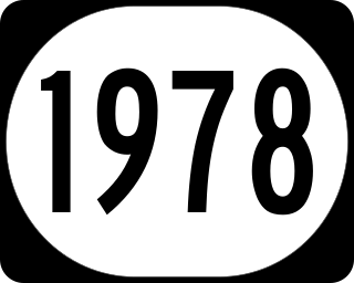
Kentucky Route 1978, known locally as Greendale Road, is an urban secondary state highway located entirely in northern Fayette County in East Central Kentucky. The 2.242 miles (3.608 km) mainly traverses the northwestern outskirts of Lexington.


