Lindsay, Oklahoma

Last updated

Lindsay, Oklahoma
Motto: 
"Working hard as a community"
OKMap-doton-Lindsay.PNG
Location of Lindsay, Oklahoma
Coordinates: 34°50′21″N97°36′37″W / 34.83917°N 97.61028°W / 34.83917; -97.61028
Country United States
State Oklahoma
County Garvin
Area
[1]
  Total2.32 sq mi (6.01 km2)
  Land2.32 sq mi (6.00 km2)
  Water0.01 sq mi (0.02 km2)
Elevation
[2]
974 ft (297 m)
Population
 (2020)
  Total2,864
  Density1,236.61/sq mi (477.46/km2)
Time zone UTC-6 (Central (CST))
  Summer (DST) UTC-5 (CDT)
ZIP code
73052
Area code 405
FIPS code 40-43150 [3]
GNIS feature ID2410840 [2]
Website www.cityoflindsay.com

Lindsay is a city in Garvin County, Oklahoma, United States. The population was 2,840 at the 2010 census. [4] It once promoted itself as "The Broomcorn Capital of the World" but no longer uses that slogan, as broomcorn is no longer raised in the area. [5]

Contents

History

The Lindsay-Murray Mansion Lindsay-murray mansion.jpg
The Lindsay-Murray Mansion

Lindsay was founded in January 1902, when the Kiowa, Chickasha and Fort Smith Railway (an affiliate of the Atchison, Topeka and Santa Fe) and the Chicago, Rock Island and Pacific railroad companies were linking their lines halfway between Chickasha and Pauls Valley, a project completed in 1903. [6] [7] The AT&SF trains from Pauls Valley turned around at Lindsay, and the Rock Island trains from Chickasha did the same. [8]

Lindsay was named after Lewis Lindsay, a local area farmer who donated 440 acres (180 ha) of land for the townsite. [9] At the time of its founding, Lindsay was located in Pickens County, Chickasaw Nation. [10]

Geography

Lindsay is located in northwestern Garvin County. The town's northern border follows the McClain County line.

Lindsay is in the Washita River valley. Oklahoma State Highway 19 passes through the center of town as Cherokee Street, leading east (downriver) 11 miles (18 km) to Maysville and northwest (generally upstream) 28 miles (45 km) to Chickasha. Oklahoma State Highway 76 leads north from Lindsay 23 miles (37 km) to Blanchard and south 46 miles (74 km) Healdton.

According to the United States Census Bureau, Lindsay has a total area of 2.3 square miles (6.0 km2), of which 0.01 square miles (0.02 km2), or 0.25%, is water. [4]

Climate

Climate data for Lindsay, Oklahoma
MonthJanFebMarAprMayJunJulAugSepOctNovDecYear
Average high °F (°C)51.0
(10.6)
56.6
(13.7)
66.4
(19.1)
75.8
(24.3)
82.4
(28.0)
89.4
(31.9)
95.6
(35.3)
95.1
(35.1)
86.4
(30.2)
76.8
(24.9)
63.9
(17.7)
53.6
(12.0)
74.4
(23.6)
Average low °F (°C)25.3
(−3.7)
30.0
(−1.1)
39.0
(3.9)
49.1
(9.5)
57.6
(14.2)
65.5
(18.6)
69.8
(21.0)
68.1
(20.1)
60.9
(16.1)
49.9
(9.9)
38.6
(3.7)
28.8
(−1.8)
48.6
(9.2)
Average precipitation inches (mm)1.3
(33)
1.8
(46)
2.9
(74)
3.4
(86)
5.4
(140)
4.0
(100)
2.1
(53)
2.4
(61)
4.3
(110)
3.7
(94)
2.2
(56)
1.7
(43)
35.1
(890)
Source 1: weather.com
Source 2: Weatherbase.com [11]

Demographics

Historical population
CensusPop.Note
1910 1,156
1920 1,54333.5%
1930 1,71311.0%
1940 1,7924.6%
1950 3,02168.6%
1960 4,25840.9%
1970 3,705−13.0%
1980 3,454−6.8%
1990 2,947−14.7%
2000 2,889−2.0%
2010 2,840−1.7%
2020 2,8640.8%
U.S. Decennial Census [12]

As of the census of 2000, [3] there were 2,889 people, 1,244 households, and 794 families residing in the city. The population density was 1,231.9 inhabitants per square mile (475.6/km2). There were 1,446 housing units at an average density of 616.6 per square mile (238.1/km2). The racial makeup of the city was 90.86% White, 0.14% African American, 4.92% Native American, 0.10% Asian, 0.03% Pacific Islander, 0.76% from other races, and 3.18% from two or more races. Hispanic or Latino of any race were 1.25% of the population.

There were 1,244 households, out of which 27.3% had children under the age of 18 living with them, 52.1% were married couples living together, 9.4% had a female householder with no husband present, and 36.1% were non-families. 34.5% of all households were made up of individuals, and 21.7% had someone living alone who was 65 years of age or older. The average household size was 2.28 and the average family size was 2.91.

In the city, the population was spread out, with 23.3% under the age of 18, 8.5% from 18 to 24, 24.1% from 25 to 44, 19.1% from 45 to 64, and 25.0% who were 65 years of age or older. The median age was 40 years. For every 100 females, there were 81.8 males. For every 100 females age 18 and over, there were 78.1 males.

The median income for a household in the city was $26,667, and the median income for a family was $35,208. Males had a median income of $26,831 versus $18,207 for females. The per capita income for the city was $14,320. About 9.9% of families and 15.6% of the population were below the poverty line, including 19.4% of those under age 18 and 12.5% of those age 65 or over.

Economy

In Lindsay, the oilfield industry is a major source of revenue and jobs.

Education

Lindsay Public Schools provide schooling from kindergarten through high school. [13]

Transportation

Lindsay is at the intersection of Oklahoma State Highway 76 and Oklahoma State Highway 19. [14] The intersection of SH-59B with SH-19 is just east of town, which leads to Oklahoma State Highway 59. [14]

The city is served by Lindsay Municipal Airport northeast of town. [15]

Parks and Attractions

The City of Lindsay has three public parks: Charlie Jones Park (on North West 4th Street), George Brown Park (on Highway 76 North, along with the Lindsay Municipal Golf Course), and Shady Grove Park (on 498 W Apache St, along with a swimming pool). [16]

The Murray-Lindsay Mansion & Pikes Peak School features an 1880 home and furnishings, built by Irish immigrant Frank Murray and his wife, Alzira McCaughey, a Choctaw Indian. It contains 15 rooms, two baths, and four fireplaces. Also on-site is a 1908 Pikes Peak two-room school house, across the road from the Mansion. [17] The Mansion is on the National Register of Historic Places listings in Garvin County, Oklahoma as "Erin Springs Mansion." [18]

Related Research Articles

<span class="mw-page-title-main">Roger Mills County, Oklahoma</span> County in Oklahoma, United States

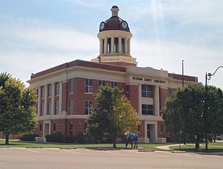
Roger Mills County is a county located in the western part of the U.S. state of Oklahoma. As of the 2020 census, the population was 3,442, making it the fourth-least populous county in Oklahoma. Its county seat is Cheyenne. The county was created in 1891.

<span class="mw-page-title-main">McClain County, Oklahoma</span> County in Oklahoma, United States

McClain County is a county located in south central Oklahoma. As of the 2020 census, the population was 41,662. Its county seat is Purcell. The county was named for Charles M. McClain, an Oklahoma constitutional convention attendee.

<span class="mw-page-title-main">Grady County, Oklahoma</span> County in Oklahoma, United States

Grady County is a county located in the U.S. state of Oklahoma. As of the 2020 census, the population was 54,795. Its county seat is Chickasha. It was named for Henry W. Grady, an editor of the Atlanta Constitution and southern orator.

<span class="mw-page-title-main">Garvin County, Oklahoma</span> County in Oklahoma, United States

Garvin County is a county in south-central Oklahoma, United States. As of the 2020 census, the population was 25,656. Its county seat is Pauls Valley. In 1906, delegates to Constitution Convention formed Garvin County from part of the Chickasaw Nation, Indian Territory. The county was named for Samuel J. Garvin, a local Chickasaw rancher, merchant and banker. Its economy is largely based on farming, ranching and oil production.

<span class="mw-page-title-main">Ellis County, Oklahoma</span> County in Oklahoma, United States

Ellis County is a county located on the western border of the U.S. state of Oklahoma. As of the 2020 census, the population was 3,749, making it the fifth-least populous county in Oklahoma. Its county seat is Arnett.

<span class="mw-page-title-main">Creek County, Oklahoma</span> County in Oklahoma, United States

Creek County is a county located in the U.S. state of Oklahoma. As of the 2020 census, the population was 71,754. Its county seat is Sapulpa.

<span class="mw-page-title-main">Carter County, Oklahoma</span> County in Oklahoma, United States

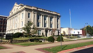
Carter County is a county in the U.S. state of Oklahoma. As of the 2020 census, the population was 48,003. Its county seat is Ardmore. The county was named for Captain Ben W. Carter, a Cherokee who lived among the Chickasaw.

<span class="mw-page-title-main">Beckham County, Oklahoma</span> County in Oklahoma, United States

Beckham County is a county located on the western border of the U.S. state of Oklahoma. As of the 2020 census, the population was 22,410. Its county seat is Sayre. Founded upon statehood in 1907, Beckham County was named for J. C. W. Beckham, who was Governor of Kentucky and the first popularly elected member of the United States Senate from Kentucky. Beckham County comprises the Elk City, OK Micropolitan Statistical Area.

<span class="mw-page-title-main">Beaver County, Oklahoma</span> County in Oklahoma, United States

Beaver County is a county located in the U.S. state of Oklahoma. As of the 2020 census, the population was 5,049. The county seat is Beaver. The name was given because of the presence of many beaver dams on the Beaver River, which runs through the area. It is located in the Oklahoma Panhandle.

<span class="mw-page-title-main">Cyril, Oklahoma</span> Town in Oklahoma, United States

Cyril is a town in Caddo County, Oklahoma, United States. The population was 1,059 at the 2010 census.

<span class="mw-page-title-main">Shattuck, Oklahoma</span> Town in Oklahoma, United States

Shattuck is a town in Ellis County, Oklahoma, United States. The population was 1,249 at the time of the 2020 census, a change from the 1,356 reported in the 2010 census.

<span class="mw-page-title-main">Maysville, Oklahoma</span> Town in Oklahoma, United States

Maysville is a town in Garvin and McClain counties, Oklahoma, United States. The population was 1,232 at the 2010 census, down from 1,313 in 2000.

<span class="mw-page-title-main">Paoli, Oklahoma</span> Town in Oklahoma, United States

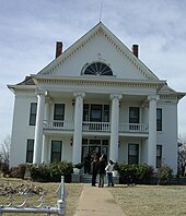
Paoli is a town in Garvin County, Oklahoma, United States. The population was 610 at the 2010 census. It was named after Paoli, Pennsylvania, an unincorporated community near Philadelphia from which many of the railroad workers who built the town came.

<span class="mw-page-title-main">Stratford, Oklahoma</span> Town in Oklahoma, United States

Stratford is a town in Garvin County, Oklahoma, United States. Prior to Oklahoma statehood in 1907, the town existed under different names and was in the Chickasaw Nation in a geographic region known as Indian Territory. Peach orchards abound in and around the town. As of the 2020 census, the town’s population was 1,405.

<span class="mw-page-title-main">Chickasha, Oklahoma</span> City in Oklahoma, United States

Chickasha is a city in and the county seat of Grady County, Oklahoma, United States. The population was 16,051 at the 2020 census, a 0.1% increase from 2010. Chickasha is home to the University of Science and Arts of Oklahoma. The city is named for and strongly connected to Native American heritage, as "Chickasha" (Chikashsha) is the Choctaw word for Chickasaw.

<span class="mw-page-title-main">Ninnekah, Oklahoma</span> Town in Oklahoma, United States

Ninnekah is a town in Grady County, Oklahoma, United States. The population was 775 at the 2020 census, a 22.7% decrease from 2010.

<span class="mw-page-title-main">Verden, Oklahoma</span> Town in Oklahoma, United States

Verden is a town in western Grady County, Oklahoma, United States. It abuts the Caddo County line, and is probably best known as the site of the 1865 Camp Napoleon Council. The population was 580 at the 2020 census, a decline from 530 in 2010.

<span class="mw-page-title-main">Laverne, Oklahoma</span> Town in Oklahoma, United States

Laverne is a town in Harper County, Oklahoma, United States. The population was 1,223 at the 2020 census.

<span class="mw-page-title-main">Strong City, Oklahoma</span> Town in Oklahoma, United States

Strong City is a town in Roger Mills County, Oklahoma, United States. As of the 2020 census, the town’s population was 33.

<span class="mw-page-title-main">Blanchard, Oklahoma</span> City in Oklahoma, United States

Blanchard is a city in McClain and Grady counties in the U.S. state of Oklahoma. The population was 8,879 at the 2020 census, up from 7,670 at the 2010 census. Blanchard is part of a rapidly growing area of northern McClain and Grady counties known as the "Tri-City Area" with Newcastle and Tuttle.

References

  1. "ArcGIS REST Services Directory". United States Census Bureau. Retrieved September 20, 2022.
  2. 1 2 U.S. Geological Survey Geographic Names Information System: Lindsay, Oklahoma
  3. 1 2 "U.S. Census website". United States Census Bureau . Retrieved January 31, 2008.
  4. 1 2 "Geographic Identifiers: 2010 Demographic Profile Data (G001): Lindsay city, Oklahoma". American Factfinder. U.S. Census Bureau. Retrieved January 23, 2017.[ dead link ]
  5. Etter, Jim. "Catchy Slogans Strive to Put Towns on Map." The Oklahoman. October 20, 1985. Accessed November 3, 2016.
  6. Railroads of Oklahoma, June 6, 1870 to April 1, 1978. State of Oklahoma Department of Transportation, Survey Division. April 1, 1978. pp. 29–39.
  7. Railroads of Oklahoma, June 6, 1870 to April 1, 1978. State of Oklahoma Department of Transportation, Survey Division. April 1, 1978. p. 43.
  8. "Who built the railroads". Mike Tower, OKGenWeb. Retrieved June 6, 2022.
  9. "Oklahoma Encyclopedia of History and Culture - Lindsay". Archived from the original on November 3, 2012. Retrieved March 3, 2011.
  10. Charles Goins, Historical Atlas of Oklahoma (Norman: University of Oklahoma Press, 2006), plate 105.
  11. "Historical Weather for Lindsay, Oklahoma, United States".
  12. "Census of Population and Housing". Census.gov. Retrieved June 4, 2015.
  13. Lindsay Public Schools, Accessed June 24, 2015.
  14. 1 2 "Lindsay, Oklahoma". Google Maps. Retrieved May 1, 2020.
  15. "Lindsay Municipal Airport". AirNav.com. Retrieved May 1, 2020.
  16. "Park Locations". City of Lindsay. Retrieved May 1, 2020.
  17. "Murray-Lindsay Mansion & Pikes Peak School". TravelOK.com. Retrieved May 1, 2020.
  18. "ERIN SPRINGS". Dianna Everett, Oklahoma Historical Society. Retrieved May 1, 2020.