
Hampshire is a ceremonial county in South East England. It is bordered by Berkshire to the north, Surrey and West Sussex to the east, the Isle of Wight across the Solent to the south, Dorset to the west, and Wiltshire to the north-west. The city of Southampton is the largest settlement, and the county town is the city of Winchester.
The subdivisions of England constitute a hierarchy of administrative divisions and non-administrative ceremonial areas.

The Metropolitan Borough of Knowsley is a metropolitan borough in Merseyside, North West England. It covers several towns and villages, including Kirkby, Prescot, Huyton, Whiston, Halewood, Cronton and Stockbridge Village; Kirkby, Huyton, and Prescot being the major commercial centres. It takes its name from the village of Knowsley, though its headquarters are in Huyton. It forms part of the wider Liverpool City Region.

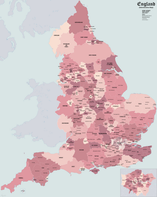
The districts of England are a level of subnational division of England used for the purposes of local government. As the structure of local government in England is not uniform, there are currently four principal types of district-level subdivision. There are a total of 296 districts made up of 36 metropolitan boroughs, 32 London boroughs, 164 two-tier non-metropolitan districts and 62 unitary authorities, as well as the City of London and the Isles of Scilly which are also districts, but do not correspond to any of these other categories. Some districts are styled as cities, boroughs or royal boroughs; these are purely honorific titles and do not alter the status of the district or the powers of their councils. All boroughs and cities are led by a mayor who in most cases is a ceremonial figure elected by the district council, but—after local government reform—is occasionally a directly elected mayor who makes most of the policy decisions instead of the council.

The counties of England are divisions of England. There are currently 48 ceremonial counties, which have their origin in the historic counties of England established in the Middle Ages. The current ceremonial counties are the result of the Lieutenancies Act 1997 and are based on the Local Government Act 1972 administrative counties which included a number of new counties such as Greater Manchester and Tyne and Wear. However, some counties introduced by the Local Government Act 1972, including Avon, Cleveland and Humberside no longer exist. The term "county", relating to any of its meanings, is used as the geographical basis for a number of institutions such as police and fire services, sports clubs and other non-government organisations.
Ceremonial counties, formally known as counties for the purposes of the lieutenancies, are areas of England to which lord-lieutenants are appointed. A lord-lieutenant is the monarch's representative in an area. Shrieval counties have the same boundaries and serve a similar purpose, being the areas to which high sheriffs are appointed. High sheriffs are the monarch's judicial representative in an area.

Inner London is the name for the group of London boroughs that form the interior part of Greater London and are surrounded by Outer London. With its origins in the bills of mortality, it became fixed as an area for statistics in 1847 and was used as an area of local government from 1855 to 1965 principally as the County of London or earlier as the Metropolitan Board of Works Area (metropolis). It now has two common definitions. The first is the statutory definition delineated in the London Government Act 1963, coming into force on 1 April 1965, comprising twelve Inner London boroughs and almost identical to the County of London that was abolished at the same time. The second is the definition used by the Office for National Statistics comprising eleven of the statutory Inner London boroughs and two of the statutory Outer London boroughs, as well as the City of London.
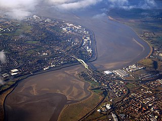
Halton is a unitary authority district with borough status in Cheshire, North West England. It was created in 1974 as a district of the non-metropolitan county of Cheshire, and became a unitary authority area on 1 April 1998 under Halton Borough Council. Since 2014, it has been a member of the Liverpool City Region Combined Authority. The borough consists of the towns of Runcorn and Widnes and the civil parishes of Daresbury, Hale, Halebank, Moore, Preston Brook, and Sandymoor. The district borders Merseyside, the Borough of Warrington and Cheshire West and Chester.
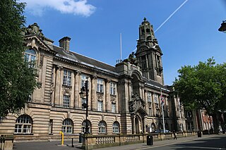
The Metropolitan Borough of Walsall is a metropolitan borough in the West Midlands, England. It is named after its largest settlement, Walsall, but covers a larger area which also includes Aldridge, Bloxwich, Brownhills, Darlaston, Pelsall and Willenhall.

Medina was a non-metropolitan district with the status of a borough on the Isle of Wight in England from 1974 to 1995.

South Wight was a non-metropolitan district with the status of a borough on the Isle of Wight in England from 1974 to 1995.

South Hampshire is a term used mainly to refer to the conurbation formed by the city of Portsmouth, city of Southampton and the non-metropolitan boroughs of Gosport, Fareham, Havant and Eastleigh in southern Hampshire, South East England. The area was estimated to have a population of over 1.5 million in 2013. It is the most populated part of South East England excluding London. The area is sometimes referred to as Solent City particularly in relation to local devolution, but the term is controversial.

Metropolitan and non-metropolitan counties are one of the four levels of subdivisions of England used for the purposes of local government outside Greater London and the Isles of Scilly. As originally constituted, the metropolitan and non-metropolitan counties each consisted of multiple districts, had a county council and were also the counties for the purposes of Lieutenancies. Later changes in legislation during the 1980s and 1990s have resulted in counties with no county council and 'unitary authority' counties with no districts. Counties for the purposes of Lieutenancies are now defined separately, based on the metropolitan and non-metropolitan counties.
The wards and electoral divisions in the United Kingdom are electoral districts at sub-national level, represented by one or more councillors. The ward is the primary unit of English electoral geography for civil parishes and borough and district councils, the electoral ward is the unit used by Welsh principal councils, while the electoral division is the unit used by English county councils and some unitary authorities. Each ward/division has an average electorate of about 5,500 people, but ward population counts can vary substantially. As of 2021 there are 8,694 electoral wards/divisions in the UK. An average area of wards in the United Kingdom is 27 km2.

The unitary authorities of England are a type of local authority responsible for all local government services in an area. They combine the functions of a non-metropolitan county council and a non-metropolitan district council, which elsewhere in England provide two tiers of local government.
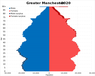
The demography of Greater Manchester is analysed by the Office for National Statistics and data is produced for each of its ten metropolitan boroughs, each of the Greater Manchester electoral wards, the NUTS3 statistical sub-regions, each of the Parliamentary constituencies in Greater Manchester, the 15 civil parishes in Greater Manchester, and for all of Greater Manchester as a whole; the latter of which had a population of 2,682,500 at the 2011 UK census. Additionally, data is produced for the Greater Manchester Urban Area. Statistical information is produced about the size and geographical breakdown of the population, the number of people entering and leaving country and the number of people in each demographic subgroup.

The Borough of Warrington is a unitary authority area with borough status in the ceremonial county of Cheshire, England. The borough is centred around the town of Warrington, and extends out into outlying villages of Lymm and Great Sankey and the town of Birchwood.
Greater London is the administrative area of London, England, coterminous with the London region. It contains 33 local government districts: the 32 London boroughs, which form a ceremonial county also called Greater London, and the City of London. The Greater London Authority is responsible for strategic local government across the region, and regular local government is the responsibility of the borough councils and the City of London Corporation. Greater London is bordered by the ceremonial counties of Hertfordshire to the north, Essex to the north-east, Kent to the south-east, Surrey to the south, and Berkshire and Buckinghamshire to the west.
