West Lancashire | |
---|---|
Borough | |
Sovereign state | United Kingdom |
Constituent country | England |
Region | North West England |
Ceremonial county | Lancashire |
Admin. HQ | Ormskirk |
Government | |
• Type | West Lancashire Borough Council |
• Leadership | Leader and Cabinet |
• MPs: |
|
Area | |
• Total | 134 sq mi (347 km2) |
• Rank | 102nd |
Population (2022) | |
• Total | 119,367 |
• Rank | Ranked 202nd |
• Density | 890/sq mi (340/km2) |
Ethnicity (2021) | |
• Ethnic groups | |
Religion (2021) | |
• Religion | List
|
Time zone | UTC+0 (Greenwich Mean Time) |
• Summer (DST) | UTC+1 (British Summer Time) |
Postcode | |
ONS code |
|
West Lancashire Borough Council | |
---|---|
Type | |
Type | |
Leadership | |
Maureen Nixon, Labour since 17 May 2023 | |
Structure | |
Seats | 45 |
Political groups | Administration (26)
Other parties (19)
|
Elections | |
Last election | 4 May 2023 |
Last election | 2 May 2024 |
Meeting place | |
52 Derby Street, Ormskirk, L39 2DF | |
Website | |
www |
West Lancashire is a local government district with borough status in Lancashire, England. The council is based in Ormskirk, and the largest town is Skelmersdale. The district borders Fylde to the north, over the Ribble Estuary; South Ribble, Chorley, and Wigan to the east; St Helens, and Knowsley to the south; and Sefton to the south and west.
The borough has a population of 117,400 and an area of 133.8 square miles (347 km2). [5] It is primarily rural, and the most populous settlements after Ormskirk and Skelmersdale are Burscough (9,935), Up Holland (7,578), and Tarleton (5,959). [6] The borough council is based in Ormskirk, and there are twenty-one civil parishes.
The west of the borough contains much of the southern part of the Lancashire Plain, a low-lying region of mossland. A large lake called Martin Mere occupied much of the area until it was drained for agriculture. The northern border of the borough is the Ribble Estuary, and both it and the remnant of Martin Mere are Ramsar sites. [7] In the west the land is rises to Harrock Hill, Parbold Hill, and Ashurst Hill; the River Douglas flows west through the valley between the last two, then turns north and forms the borough boundary.
The district was created on 1 April 1974 under the Local Government Act 1972, covering the whole area of two former districts and parts of another two districts, all of which were abolished at the same time: [8]
In 2009 the district was awarded borough status, causing the council to change its name from West Lancashire District Council to West Lancashire Borough Council, and allowing the chairman of the council to take the title of mayor. [9] [10]
Proposals to divide Lancashire into three unitary authorities were put forward in 2020, which would have seen both Lancashire County Council and West Lancashire Borough Council abolished. [11] The Government did not pursue that proposed reform, although left open the possibility of other forms of reorganisation in future. [12]
West Lancashire Borough Council provides district-level services. County-level services are provided by Lancashire County Council. [13] Parts of the district are also covered by civil parishes, which form a third tier of local government. [14]
The council employs around 600 people, making it one of West Lancashire's largest employers. It is responsible for the administration of various services, such as leisure, waste collection, planning permission and pest control. [3]
The council has been under Labour majority control since 2023.
The first election to the council was held in 1973, initially operating as a shadow authority alongside the outgoing authorities until the new arrangements came into effect on 1 April 1974. Political control of the council since 1974 has been as follows: [15] [16]
Party in control | Years | |
---|---|---|
No overall control | 1974–1976 | |
Conservative | 1976–1986 | |
No overall control | 1986–1987 | |
Conservative | 1987–1991 | |
No overall control | 1991–1994 | |
Labour | 1994–2002 | |
Conservative | 2002–2014 | |
No overall control | 2014–2015 | |
Labour | 2015–2021 | |
No overall control | 2021–2023 | |
Labour | 2023–present |
The role of mayor is largely ceremonial in West Lancashire. Political leadership is instead provided by the leader of the council. The leaders since 1992 have been: [17]
Councillor | Party | From | To | |
---|---|---|---|---|
Alan Bullen | Labour | 1992 | 15 May 2002 | |
Geoff Roberts | Conservative | 15 May 2002 | 21 May 2008 | |
Ian Grant | Conservative | 21 May 2008 | 25 May 2014 | |
David Westley | Conservative | 11 Jun 2014 | 20 May 2015 | |
Ian Moran | Labour | 20 May 2015 | 8 May 2022 | |
Yvonne Gagen | Labour | 18 May 2022 |
Following the 2023 election, the composition of the council was: [18]
Party | Councillors | |
---|---|---|
Labour | 26 | |
Conservative | 15 | |
OWL | 4 | |
Total | 45 |
The next election is due in 2024.
The council is based at 52 Derby Street in Ormskirk, which was originally a pair of large semi-detached Victorian houses called Beaconsfield (number 52) and Abbotsford (number 54). [19] Beaconsfield was purchased in 1925 by West Lancashire Rural District Council, one of the modern council's predecessors, and converted to become its headquarters, being formally opened on 30 July 1925. [20] Abbotsford was acquired later and the building has been significantly extended to the rear. [21]
Since the last boundary changes in 2023 the council has comprised 45 councillors representing 15 wards, with each ward electing three councillors. Elections are held three years out of every four, with a third of the council (one councillor for each ward) being elected each time for a four-year term. Lancashire County Council elections are held in the fourth year of the cycle when there are no borough council elections. [22]
Since the last election in May 2023, the composition of the council has been as follows. The next election is due in 2024. [23]
Ward | Name | Party | |
---|---|---|---|
Aughton and Holborn | Paul Hennessy | Labour Party | |
Sarah Lawton | Labour Party | ||
Kerry Lloyd | Labour Party | ||
Burscough Bridge and Rufford | John Gordon | Conservative Party | |
Eddie Pope | Conservative Party | ||
Paul Hesketh | Our West Lancashire | ||
Burscough Town | Patricia Burnside | Labour Party | |
Andrew Fowler | Labour Party | ||
Judy Abbott | Labour Party | ||
North Meols and Hesketh Bank | Ian Eccles | Conservative Party | |
Thomas De Freitas | Conservative Party | ||
John Howard | Conservative Party | ||
Old Skelmersdale | Neil Furey | Labour Party | |
Nicola Pryce-Roberts | Labour Party | ||
Donna West | Labour Party | ||
Ormskirk East | Nicola Hennessy | Labour Party | |
Robert Molloy | Labour Party | ||
Janet Ingman | Our West Lancashire | ||
Ormskirk West | Mark Anderson | Labour Party | |
Gareth Dowling | Labour Party | ||
Anne Fennell | Labour Party | ||
Rural North East | Robert Bailey | Conservative Party | |
Katie Juckes | Conservative Party | ||
David Whittington | Conservative Party | ||
Rural South | Adrian Owens | Our West Lancashire | |
Ian Rigby | Our West Lancashire | ||
Linda Webster | Our West Lancashire | ||
Rural West | Alexander Blundell | Conservative Party | |
Jane Marshall | Conservative Party | ||
Marilyn Westley | Conservative Party | ||
Skelmersdale North | Terence Devine | Labour Party | |
Yvonne Gagen | Labour Party | ||
Melissa Parlour | Labour Party | ||
Skelmersdale South | Terence Aldridge | Labour Party | |
Victoria Cummins | Labour Party | ||
Julian Finch | Labour Party | ||
Tanhouse and Skelmersdale Town Centre | Carl Coughlan | Labour Party | |
Paul Hogan | Labour Party | ||
Maureen Nixon | Labour Party | ||
Tarleton Village | Darren Daniels | Conservative Party | |
David Westley | Conservative Party | ||
John Mee | Conservative Party | ||
Up Holland | John Fillis | Labour Party | |
Gaynar Owen | Labour Party | ||
Suresh Patel | Labour Party | ||
The south of West Lancashire, including the towns of Burscough, Skelmersdale and Ormskirk fall under the West Lancashire constituency in the House of Commons, which has been represented by Labour Party MP Ashley Dalton since the 2023 West Lancashire by-election, whereas the north of West Lancashire falls under the South Ribble constituency, which has been represented by Conservative Party MP Katherine Fletcher since the 2019 general election.
Skelmersdale, a former New Town, and Ormskirk are the two main towns in the borough. These are surrounded by a patchwork of smaller settlements to the west and north.
There are 21 civil parishes in West Lancashire. The main towns of Skelmersdale and Ormskirk are unparished areas. There is a movement to establish a town council in Skelmersdale. [24] The parish council of Burscough takes the style "town council". [25]
All the civil parishes have a parish council, with the exception of Bispham, which has a parish meeting instead.
In terms of television, the area is served by BBC North West and ITV Granada broadcasting from the Winter Hill transmitter. [26]
Radio stations for the area are:
Local newspaper is the Lancashire Telegraph . [27]
West Lancashire is twinned with: [28]
|
|
Ormskirk is a market town in the West Lancashire district of Lancashire, England. It is located 13 miles (21 km) north of Liverpool, 11 miles (18 km) northwest of St Helens, 9 miles (14 km) southeast of Southport and 18 miles (29 km) southwest of Preston. Ormskirk is known for its gingerbread. In 2011 it had a population of 24,073.
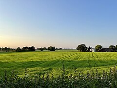
Parbold is a village and civil parish in West Lancashire, England.
Burscough is a town and civil parish in the district of West Lancashire, Lancashire, England. The town is located approximately 13.5 miles (21.7 km) north-northeast of Liverpool and 13 miles (21 km) southwest of Preston. Its northern part is called Burscough Bridge, and was originally a separate settlement.
West Lancashire is a county constituency represented in the House of Commons of the UK Parliament. Following the resignation of Labour MP Rosie Cooper on 30 November 2022, the seat was won by the party's candidate Ashley Dalton in the by-election held on 9 February 2023.
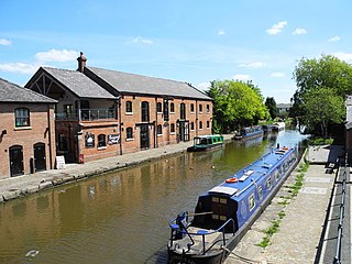
Lathom is a village and civil parish in Lancashire, England, about 3 miles (5 km) northeast of Ormskirk. It is in the district of West Lancashire, and with the parish of Newburgh forms part of Newburgh ward. The population of the civil parish at the 2011 census was 914. The Leeds and Liverpool Canal passes through Lathom.
Bispham Green is a village in the West Lancashire district of Lancashire, England. It is 1 mile (1.6 km) south of Mawdesley and less than 1 mile (1.6 km) north of Parbold.
Ormskirk was a county constituency represented in the House of Commons of the Parliament of the United Kingdom. It elected one Member of Parliament (MP) by the first past the post system of election. It was created by the Redistribution of Seats Act 1885 as a division of the parliamentary county of Lancashire. The constituency boundaries were changed in 1918, 1950, 1955 and 1974.
West Lancashire Borough Council elections are generally held three years out of every four, with a third of the council elected each time. West Lancashire Borough Council is the local authority for the non-metropolitan district of West Lancashire in Lancashire, England. Since the last boundary changes in 2023 the council has comprised 45 councillors representing 15 wards, with each ward electing three councillors.
Ormskirk was an urban district in the county of Lancashire from 1894 to 1974. It was named after the town of Ormskirk, which constituted its main settlement.
Newburgh is a rural village and civil parish in Lancashire, England, 3 miles (5 km) from Skelmersdale and 5 miles (8 km) from Ormskirk. Its population in 2011 was 1,056 and 1,065 in 2021.
There are a number of listed buildings in Lancashire. The term "listed building", in the United Kingdom, refers to a building or structure designated as being of special architectural, historical, or cultural significance. Details of all the listed buildings are contained in the National Heritage List for England. They are categorised in three grades: Grade I consists of buildings of outstanding architectural or historical interest, Grade II* includes significant buildings of more than local interest and Grade II consists of buildings of special architectural or historical interest. Buildings in England are listed by the Secretary of State for Culture, Media and Sport on recommendations provided by English Heritage, which also determines the grading.
Wrightington is a civil parish in West Lancashire, England, with an area of 3,915½ acres. The surface is hilly, rising to over 400 ft. at Harrock on the border of Parbold, and then falling to the north, northeast and southeast. On the southern border, the boundary at Appley Bridge touches the River Douglas. Wrightington Hall is to the north of this point. Tunley and Broadhurst lie to the north of the park, and Fairhurst, to the west of Harrock, reaches down to the River Douglas. At the 2001 census, Wrightington had a population of 4,055, falling to 2,886 at the 2011 Census.
Lathom South is a civil parish in the West Lancashire district of Lancashire, England, situated near the towns of Ormskirk and Skelmersdale. The parish council was established in 2007, and the area, which includes the hamlets of Blaguegate and Scarth Hill, has historical ties to the neighbouring parish of Lathom. As of 2011, Lathom South has a population of 657.
Hilldale is a civil parish in the West Lancashire district of Lancashire, England, containing the village of Hill Dale and the neighbouring hamlet of Andertons Mill. Formerly part of Wrightington, Hilldale became a separate civil parish in 1999. As of 2011, Hilldale has a population of 581.
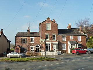
Westhead is a village in the West Lancashire district of Lancashire, England. As of 2014, the estimated population was 886.
Roby Mill is a village in the West Lancashire district of Lancashire, England. The estimated population is 405.