List of colonial churches in Mexico City

Last updated

The sixteen municipalities (Alcaldias) of Mexico City. MX-DF-Division politica.svg
The sixteen municipalities (Alcaldías) of Mexico City.

This is a list of the preserved Colonial churches in Mexico City , the capital of Mexico.

Contents

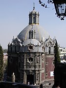
Aside from being a notable city in colonial times, the city grew in the 20th century enormously in terms of population, adhering to over a hundred of suburbs close to the city (former suburbs today called "pueblos originarios" or "colonias"). This is why the churches of the colonial city are only those located in the center, the rest of the churches listed are also colonial but of former suburbs, today parts of the city.

Mexico City is home to the first and oldest European school of higher learning in the Americas, the same building was the first major school of interpreters and translators in the New World (Colegio de Santa Cruz de Tlatelolco); also the main pilgrimage site in the Americas (Basilica of Our Lady of Guadalupe). [1] [2]

Criteria

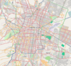
The list only includes Colonial-era places of Christian worship, and the list does not include the Greater Mexico City churches outside Mexico City; only include within the 16 boroughs (alcaldías) of Mexico City proper.

These churches are protected real estates that are heritage of the nation, and are declared as such in the Public Register of Monuments and Archaeological Zones of the Instituto Nacional de Antropología e Historia (INAH), in accordance with the Federal law on monuments and archaeological, artistic and historical zones of Mexico.

Buildings in the Historic center of Mexico City, Xochimilco and Central University City Campus of the UNAM are World Heritage Sites by UNESCO.

List

NameImageBuiltArchitectural styleArchitect(s)Belonged to the religious orderSourceLocationConservationID
Convent of the College of Santa Cruz de Tlatelolco Templo y Ex Convento, Santiago Tlatelolco.jpg 1536 Baroque Franciscans [3] [4]
Location map Mexico City.png
Red pog.svg
Location within Mexico City
General information
LocationPlaza de las Tres Culturas, Eje Central Lázaro Cárdenas, Nonoalco Tlatelolco, Center
Coordinates 19°27′2.76″N99°8′12.13″W / 19.4507667°N 99.1367028°W / 19.4507667; -99.1367028 (College of Santa Cruz de Tlatelolco)
Good conditionM-09-285-00-00
Convent of San Andrés Apóstol de Míxquic ChurchBellMixquic.JPG 1536-1620 Order of Saint Augustine [5] [6]
Mexican Federal District.svg
Red pog.svg
Location within Mexico City
General information
Locationcalle Independencia 1, barrio de San Agustín Míxquic, Tláhuac
Coordinates 19°13′31.41″N98°57′51.3″W / 19.2253917°N 98.964250°W / 19.2253917; -98.964250 (Church and Convent of San Andrés Apóstol de Míxquic)
Good condition05362
Convent of Nuestra Señora de la Concepción 20200704 093956 HDR.jpg 1540 Baroque Conceptionists [7]
Location map Mexico City.png
Red pog.svg
Location within Mexico City
General information
LocationBelisario Domínguez 5, Center (ZMH "A")
Coordinates 19°26′17.55″N99°8′22.96″W / 19.4382083°N 99.1397111°W / 19.4382083; -99.1397111 (Convent of Nuestra Señora de la Concepción)
Good condition06434
Church of San Agustín Isebel la Catolica y Republica de Uruguay - panoramio.jpg 1541-1692 Renaissance, Neoclassical Order of Saint Augustine [8]
Location map Mexico City.png
Red pog.svg
Location within Mexico City
General information
LocationRepública de Uruguay 69 corner with Isabel La Católica, Center (ZMH "A")
Coordinates 19°25′47.05″N99°8′10.03″W / 19.4297361°N 99.1361194°W / 19.4297361; -99.1361194 (Church of San Agustín)
Benches, confessionals and altar were recently rebuilt but the rest remains in good condition00931
Convent of San Marcos Apóstol de Mexicaltzingo Parroquia de San Marcos Mexicaltzingo 5.jpg 1555-1560 Baroque Franciscans [9]
Location map Mexico City.png
Red pog.svg
Location within Mexico City
General information
LocationRoad Ermita Iztapalapa 475, San Marcos Mexicaltzingo, Iztapalapa
Coordinates 19°21′26.69″N99°7′11.12″W / 19.3574139°N 99.1197556°W / 19.3574139; -99.1197556 (Church and Convent of San Marcos Apóstol de Mexicaltzingo)
The convent had a second floor that no longer exists. The rest of the church is preserved in good condition.00847
Parish and Covent of San Juan Bautista, Coyoacán Parroquia y Ex Convento de San Juan Bautista.jpg 1560-1804 Herrerian Dominican Order [10]
Location map Mexico City.png
Red pog.svg
Location within Mexico City
General information
LocationJardín Centenario 8, Coyoacán
Coordinates 19°20′56.1″N99°9′44.5″W / 19.348917°N 99.162361°W / 19.348917; -99.162361 (Parish and Covent of San Juan Bautista, Coyoacán)
The mural paintings of the interior were made in 1944, all the rest of the church is from Colonial times.00087
Chapel of San Salvador Capilla San Salvador, Nextengo, Azcapotzalco (1).jpg 1562-17th century Baroque Dominican Order [11]
Location map Mexico City.png
Red pog.svg
Location within Mexico City
General information
LocationCamino de Nextengo 25 corner with Centenario, Barrio de Nextengo, Azcapotzalco
Coordinates 19°28′17″N99°11′18″W / 19.471415°N 99.188327°W / 19.471415; -99.188327 (Chapel of San Salvador)
In 1967 was removed eight meters from the top of the portal to add a modern window, and four windows were added to the side facade.05312
Convent of San Jacinto Church San Jacinto San Angel.jpg 1564-1614 Churrigueresque Dominican Order [12]
Location map Mexico City.png
Red pog.svg
Location within Mexico City
General information
LocationPlaza de San Jacinto 18 bis, San Ángel, Álvaro Obregón
Coordinates 19°20′41″N99°11′36″W / 19.3446556°N 99.1934147°W / 19.3446556; -99.1934147 (Church and Convent of San Jacinto)
Good condition00376
Parish and Convent of los Santos Apóstoles Felipe y Santiago El Menor FelipeSantiagoAzca02.JPG 1565-1720 Baroque, Churrigueresque, Renaissance Friar Lorenzo de la Asunción Dominican Order [13]
Location map Mexico City.png
Red pog.svg
Location within Mexico City
General information
LocationAv. Azcapotzalco, Tepanecos, Belisario Domínguez and Morelos streets, Azcapotzalco
Coordinates 19°28′50″N99°11′07″W / 19.4805511°N 99.1853052°W / 19.4805511; -99.1853052 (Parish and Convent of San Felipe y Santiago Apóstoles)
Good condition00081
Convent of Clarisas (now the Library of the Congress of Mexico) SantaClaraLibraryCongress1.JPG 1568-1730 Baroque Poor Clares [14]
Location map Mexico City.png
Red pog.svg
Location within Mexico City
General information
LocationTacuba 29, Center (ZMH "A")
Coordinates 19°26′7.67″N99°8′15.95″W / 19.4354639°N 99.1377639°W / 19.4354639; -99.1377639 (Convent of Clarisas)
Good condition
Parish of Santa Catarina Mártir Santa caterina Messico.jpg 1568-1740 Renaissance, Baroque Cristóbal de Medina Vargas [15]
Location map Mexico City.png
Red pog.svg
Location within Mexico City
General information
LocationCalle República de Brasil corner with República de Nicaragua, Barrio de la Lagunilla, Center (ZMH "A")
Coordinates 19°26′27.61″N99°7′57.83″W / 19.4410028°N 99.1327306°W / 19.4410028; -99.1327306 (Parish of Santa Catarina)
Deteriorate00189
Parish of Santa Isabel de Portugal Parroquia Santa Isabel de Portugal, vista lateral.jpg 1570-1580 Plateresque Franciscans [16]
Location map Mexico City.png
Red pog.svg
Location within Mexico City
General information
LocationNezahualcoyotl, Santa Isabel Tola, Gustavo A. Madero
Coordinates 19°29′59.43″N99°6′55.88″W / 19.4998417°N 99.1155222°W / 19.4998417; -99.1155222 (Parish of Santa Isabel de Portugal)
Good condition00956
Convent of San Pedro Apóstol, San Pedro Actopan FacAtriumSanPedroAtocpan.JPG 1570-1680 Plateresque Franciscans [17] [18]
Mexican Federal District.svg
Red pog.svg
Location within Mexico City
General information
LocationVenustiano Carranza 127, Pueblo, San Pedro Actopan, Milpa Alta
Coordinates 19°12′7.27″N99°3′15.55″W / 19.2020194°N 99.0543194°W / 19.2020194; -99.0543194 (Convent of San Pedro Apóstol, San Pedro Actopan)
Good condition06451
Parish of San Mateo Tlaltenango PARROQUIA SAN MATEO APOSTOL.jpg 1571 Baroque, Neoclassical Franciscans [19]
Mexican Federal District.svg
Red pog.svg
Location within Mexico City
General information
LocationMiguel Hidalgo, Col. San Mateo Tlaltenango, 05600, Cuajimalpa de Morelos
Coordinates 19°20′31.7″N99°16′46.79″W / 19.342139°N 99.2796639°W / 19.342139; -99.2796639 (Parish of San Mateo Tlaltenango)
Good condition00926
Mexico City Metropolitan Cathedral Zocalo cathedral.jpg 1573-1813 Gothic, Plateresque, Baroque Claudio de Arciniega, Juan Gómez de Trasmonte, José Eduardo de Herrera, José Damián Ortiz de Castro, Manuel Tolsá [20]
Location map Mexico City.png
Red pog.svg
Location within Mexico City
General information
LocationPlaza de la Constitución, Center (ZMH "A")
Coordinates 19°26′3.45″N99°7′59.15″W / 19.4342917°N 99.1330972°W / 19.4342917; -99.1330972 (Mexico City Metropolitan Cathedral)
Good condition00206
Church and College of San Pedro y San Pablo (now the Museum of Constitutions) FacadeMuseoLuzDF.JPG 1576-1645 Baroque, Neoclassical Jesuit Diego López de Arbaizo, Diego López de Albaize Society of Jesus [21]
Location map Mexico City.png
Red pog.svg
Location within Mexico City
General information
LocationSan Ildefonso Street to República de Venezuela, Del Carmen 31, Center (ZMH "A")
Coordinates 19°26′11.6″N99°7′45.58″W / 19.436556°N 99.1293278°W / 19.436556; -99.1293278 (Church and College of San Pedro y San Pablo)
Good condition00190
Church of San Simón y San Judas Tadeo Templo de San Simon y San Judas Tadeo.JPG 1579-18th century Baroque Dominican Order [22]
Location map Mexico City.png
Red pog.svg
Location within Mexico City
General information
LocationCalle Zaragoza between Porvenir and Esperanza, Barrio de San Simón Pochtlan, Azcapotzalco
Coordinates 19°28′58.81″N99°11′12.12″W / 19.4830028°N 99.1867000°W / 19.4830028; -99.1867000 (Church of San Simón y San Judas Tadeo)
One of its doors dates from 1838, in 1984 the atrium was remodeled and rebuilt, the rest of the church is in good condition.00915
Convent of Nuestra Señora de Montserrat (now the Charrería Museum) Templo Montserrat.jpg 1580 Baroque Benedictines [23]
Location map Mexico City.png
Red pog.svg
Location within Mexico City
General information
LocationIsabel la Católica 108, Center (ZMH "B")
Coordinates 19°25′30.08″N99°8′13.81″W / 19.4250222°N 99.1371694°W / 19.4250222; -99.1371694 (Convent of Nuestra Señora de Montserrat)
It was partially demolished. What's left is in good conditionM-09-283-00-00
Chapel of San Sebastián Mártir San Sebastian Martir.jpg 1585-17th century Baroque Carmelites [24]
Location map Mexico City.png
Red pog.svg
Location within Mexico City
General information
LocationCalle de San Sebastián, Plaza Federico Gamboa 11, Chimalistac, Álvaro Obregón
Coordinates 19°20′49.93″N99°11′3.04″W / 19.3472028°N 99.1841778°W / 19.3472028; -99.1841778 (Chapel of San Sebastián Mártir, Chimalistac)
The facade has been modified until the 1960s. The bell tower and the rest of the ensemble are from Colonial times. It is in good condition.00375
Convent of la Asunción de María de Milpa Alta AsuncionMariaMilpaAlta02.JPG 1585-1630 Baroque Franciscans [25] [26]
Mexican Federal District.svg
Red pog.svg
Location within Mexico City
General information
LocationAv. México 1010, center of Milpa Alta
Coordinates 19°11′32.6″N99°1′21.09″W / 19.192389°N 99.0225250°W / 19.192389; -99.0225250 (Church and Convent of la Asunción de María de Milpa Alta)
Good condition01373
Convent of San Pedro Apóstol de Tláhuac ParishSanPedroTlahuac 04.JPG 1587-1806 Renaissance Ignacio Castera, Francisco Becerra Dominican Order [27]
Mexican Federal District.svg
Red pog.svg
Location within Mexico City
General information
LocationSeverino Ceniceros, Barrio de San Miguel, San Pedro Tláhuac, Tláhuac
Coordinates 19°16′8.83″N99°0′15.3″W / 19.2691194°N 99.004250°W / 19.2691194; -99.004250 (Church and Convent of San Pedro Apóstol de Tláhuac)
Good condition09013
Convent of San Diego de Alcalá Templo de San Diego 05.JPG 1591-1778 Neoclassical Discalced Franciscans [28]
Location map Mexico City.png
Red pog.svg
Location within Mexico City
General information
LocationDoctor Mora 7, Center (ZMH "B")
Coordinates 19°26′11.38″N99°8′48.17″W / 19.4364944°N 99.1467139°W / 19.4364944; -99.1467139 (Convent of San Diego de Alcalá)
Good condition00220
Convent of San Jerónimo (now the main auditorium of the University of the Cloister of Sor Juana) Claustro de Sor Juana.jpg 1592-1665 Herrerian Cristóbal de Medina Vargas Hieronymites [29]
Location map Mexico City.png
Red pog.svg
Location within Mexico City
General information
LocationIzazaga 92, Center (ZMH "A")
Coordinates 19°25′35.72″N99°8′11.88″W / 19.4265889°N 99.1366333°W / 19.4265889; -99.1366333 (Convent of San Jerónimo)
Good condition01954
Convent and Parish of Santo Domingo de Guzmán Parroquia de Santo Domingo de Guzman, Ciudad de Mexico 02.JPG 1595-1648 Baroque Dominican Order [30]
Location map Mexico City.png
Red pog.svg
Location within Mexico City
General information
LocationCanova 2, Insurgentes Mixcoac, 03920, Benito Juárez
Coordinates 19°22′19″N99°10′59″W / 19.3719874°N 99.1829636°W / 19.3719874; -99.1829636 (Convent and Parish of Santo Domingo de Guzmán)
The interior of the church corresponds to very recent dates, the exterior and the cloister is from Colonial times.00084
Royal Convent of Jesús y María JM1.JPG 1597-1621 Baroque Conceptionists [31] [32]
Location map Mexico City.png
Red pog.svg
Location within Mexico City
General information
LocationJesús María 49, Center (ZMH "A")
Coordinates 19°25′53.47″N99°7′42.06″W / 19.4315194°N 99.1283500°W / 19.4315194; -99.1283500 (Royal Convent of Jesús y María)
Good condition00021
Church of San Felipe Neri "La Profesa" LaProfesaMuseo06.JPG 1597-1805 Baroque, Neoclassical Juan Pérez de Soto, Pedro de Arrieta, Manuel Tolsá Society of Jesus [33]
Location map Mexico City.png
Red pog.svg
Location within Mexico City
General information
LocationCalle Isabel la Católica 21, Center (ZMH "A")
Coordinates 19°26′1.44″N99°8′11.57″W / 19.4337333°N 99.1365472°W / 19.4337333; -99.1365472 (La Profesa)
Good condition00250
Convent of Santa Inés (now the José Luis Cuevas Museum) Templo de Santa Ines 2012-09-30 15-38-02.jpg 1598-1600 Baroque Alonso Martínez López Conceptionists [34]
Location map Mexico City.png
Red pog.svg
Location within Mexico City
General information
LocationAcademia 13, Center (ZMH "A")
Coordinates 19°26′1.08″N99°7′44.71″W / 19.4336333°N 99.1290861°W / 19.4336333; -99.1290861 (Convent of Santa Inés)
The tower was demolished and the rest is in good condition05448
Church and Hospital of San Hipólito HipolitoReformaDF.JPG 1599-1739 Baroque [35]
Location map Mexico City.png
Red pog.svg
Location within Mexico City
General information
LocationAv. Hidalgo 103, Guerrero, Center (ZMH "A")
Coordinates 19°26′17″N99°8′48.66″W / 19.43806°N 99.1468500°W / 19.43806; -99.1468500 (Church and Hospital of San Hipólito)
In 1893 the interior of the church was remodeled. The exterior of the church is from Colonial times.00261
College and Church of Nuestra Señora de Lourdes Iglesia lourdes.jpg 16th-17th centuries Baroque, Neoclassical [36]
Location map Mexico City.png
Red pog.svg
Location within Mexico City
General information
LocationBolívar 37, Center (ZMH "A")
Coordinates 19°25′54.78″N99°8′19.4″W / 19.4318833°N 99.138722°W / 19.4318833; -99.138722 (College and Church Nuestra Señora de Lourdes)
Good condition00169
Parish of San Lucas Evangelista Fachada Parroquia San Lucas Evangelista (Iztapalapa).JPG mid 16th century Neoclassical [37]
Location map Mexico City.png
Red pog.svg
Location within Mexico City
General information
Location5 de Mayo 162, Hidalgo 7, Col. San Lucas. 09000, Iztapalapa
Coordinates 19°21′38.64″N99°5′31.33″W / 19.3607333°N 99.0920361°W / 19.3607333; -99.0920361 (Parish of San Lucas Evangelista)
Good conditionM-09-275-04-00
Parish of la Asunción of Santa María Nonoalco Parroquia de la Asuncion de Santa Maria.JPG 16th century Baroque [30]
Location map Mexico City.png
Red pog.svg
Location within Mexico City
General information
LocationBetween the strets Van Dick and Allori 166, Santa María Nonoalco, Mixoac, Benito Juárez
Coordinates 19°22′45.35″N99°11′38″W / 19.3792639°N 99.19389°W / 19.3792639; -99.19389 (Parish of la Asunción of Santa María Nonoalco)
Good condition
Church of San Pablo el viejo Ex Templo de San Pablo el Viejo.jpg late 16th-early 17th centuries Renaissance Order of Saint Augustine [38]
Location map Mexico City.png
Red pog.svg
Location within Mexico City
General information
LocationSan Pablo 21, La Merced, Center (ZMH "B")
Coordinates 19°25′32.64″N99°7′46.29″W / 19.4257333°N 99.1295250°W / 19.4257333; -99.1295250 (Church of San Pablo el viejo)
Good condition00358
Convent of San Matías Apóstol de Iztalaco SanMatiasChurchIztacalco02.jpg 16th century-1725 Renaissance, Baroque Claudio de Arciniega, José Miguel de Rivera Saravia Franciscans [39]
Location map Mexico City.png
Red pog.svg
Location within Mexico City
General information
LocationJuárez 4, La Asunción, Iztacalco
Coordinates 19°23′24.63″N99°7′15.28″W / 19.3901750°N 99.1209111°W / 19.3901750; -99.1209111 (Church and Convent of San Matías Apóstol de Iztalaco)
Good condition00836
Church of Santa Catarina de Coyoacán SantaCatarinaChurch2.JPG 16th century-1740 Baroque Franciscans [40]
Location map Mexico City.png
Red pog.svg
Location within Mexico City
General information
LocationPlaza de Sta. Catarina No. 5, Barrio de Sta. Catarina, Coyoacán (ZMH "A")
Coordinates 19°20′59.11″N99°10′13.6″W / 19.3497528°N 99.170444°W / 19.3497528; -99.170444 (Church of Santa Catarina, Coyoacán)
Lost the roof lantern of the bell tower due to the 1985 earthquake, and was rebuilt the roof lantern.00104
Chapel of San Lucas Evangelista Parroquia San Lucas Evangelista, Del Recreo, Azcapotzalco.jpg 16th-17th centuries Neoclassical [41]
Location map Mexico City.png
Red pog.svg
Location within Mexico City
General information
LocationCalle San Lucas 15 corner Privada de San Lucas; Col. El Recreo, Barrio de San Lucas, Azcapotzalco
Coordinates 19°28′18.93″N99°11′10.6″W / 19.4719250°N 99.186278°W / 19.4719250; -99.186278 (Chapel of San Lucas Evangelista)
Good condition05315
Chapel of Santa María Malinalco Capilla de Santa Maria Malinalco (Azcapotzalco) 03.JPG 16th-17th centuries Franciscans [42]
Location map Mexico City.png
Red pog.svg
Location within Mexico City
General information
LocationCalle Dr. Galeana corner with alley Aspiros, Santa María Malinalco, Azcapotzalco
Coordinates 19°28′33.71″N99°10′56.42″W / 19.4760306°N 99.1823389°W / 19.4760306; -99.1823389 (Chapel of Santa María Malinalco)
Good condition05326
Convent of Santa Marta de Acatitla ParishAcatitla07.JPG 16th century Baroque [43]
Location map Mexico City.png
Red pog.svg
Location within Mexico City
General information
LocationFrancisco I. Madero 2, Col. Santa Martha Acatitla, 09510, Iztapalapa
Coordinates 19°21′45.63″N99°0′39.39″W / 19.3626750°N 99.0109417°W / 19.3626750; -99.0109417 (Church and Convent of Santa Marta de Acatitla)
Good condition01356
Church of la Inmaculada Concepción IglesiaConcepcionContreras02.JPG 16th-18th centuries Neoclassical [44]
Location map Mexico City.png
Red pog.svg
Location within Mexico City
General information
LocationPlaza de la Concepción, Camino Real to Contreras 6, La Concepción, La Magdalena Contreras
Coordinates 19°18′12.42″N99°14′5.8″W / 19.3034500°N 99.234944°W / 19.3034500; -99.234944 (Church of la Inmaculada Concepción)
Good condition01358
Parish of San Jerónimo Church of San Jeronimo Aculco, San Jeronimo Lidice, Magdalena Contreras, Mexico City.JPG 16th century Baroque Franciscans [45]
Location map Mexico City.png
Red pog.svg
Location within Mexico City
General information
LocationAv. San Jerónimo, San Jerónimo Lídice, 10200, La Magdalena Contreras
Coordinates 19°19′35.71″N99°13′19.82″W / 19.3265861°N 99.2221722°W / 19.3265861; -99.2221722 (Parish of San Jerónimo)
Danger of collapse01360
Church and Hospital of Jesús Nazareno Templo del hospitald de jesus.jpg 1601-mid 19th century Renaissance Pedro Vázquez, Alonso Pérez de Castañeda, Antonio de Calderón Benavides, Diego Martín, Manuel Joseph de Herrera [46]
Location map Mexico City.png
Red pog.svg
Location within Mexico City
General information
LocationRepública de El Salvador 119, Center (ZMH "A")
Coordinates 19°25′44.28″N99°7′58.96″W / 19.4289667°N 99.1330444°W / 19.4289667; -99.1330444 (Church and Hospital of Jesús Nazareno)
the altarpiece was dismantled, the rest is in good condition.00240
Convent of La Merced TowerLaMercedDF.JPG 1602-1703 Mudéjar Lázaro de Torres Order of the Blessed Virgin Mary of Mercy [47]
Location map Mexico City.png
Red pog.svg
Location within Mexico City
General information
LocationRepública de Uruguay 170, Center (ZMH "A")
Coordinates 19°25′46.14″N99°7′40.21″W / 19.4294833°N 99.1278361°W / 19.4294833; -99.1278361 (Convent of La Merced)
The cloister remains and is in good condition00027
Convent of the Desierto de los Leones Ex-Convento Desierto de los Leones.jpg 1606-1814 Baroque Discalced Carmelites [48]
Mexican Federal District.svg
Red pog.svg
Location within Mexico City
General information
LocationColonia Altavista and San Angel, Cuajimalpa and Álvaro Obregón
Coordinates 19°18′48.28″N99°18′37.36″W / 19.3134111°N 99.3103778°W / 19.3134111; -99.3103778 (Convent of the Desierto de los Leones)
In ruinsM-09-273-04-00
Chapel of the Convent of Nuestra Señora de la Merced de las Huertas Templo Merced de Las Huertas 2013-09-08 14-25-36.jpg 1607-1680 Baroque Order of the Blessed Virgin Mary of Mercy [49]
Location map Mexico City.png
Red pog.svg
Location within Mexico City
General information
LocationRoad México - Tacuba 305, Nextitla, Miguel Hidalgo
Coordinates 19°27′4.79″N99°10′22.69″W / 19.4513306°N 99.1729694°W / 19.4513306; -99.1729694 (Church and Convent of Nuestra Señora del Carmen)
Good condition01369
Convent of Nuestra Señora del Carmen (now the El Carmen Museum) El Carmen Church San Angel.jpg 1615-1626 Baroque Friar Andrés de San Miguel Discalced Carmelites [50]
Location map Mexico City.png
Red pog.svg
Location within Mexico City
General information
LocationAv. Revolución 4, Col. San Ángel. 01000, San Ángel, Álvaro Obregón
Coordinates 19°20′42″N99°11′21.84″W / 19.34500°N 99.1894000°W / 19.34500; -99.1894000 (Church and Convent of Nuestra Señora del Carmen)
Good condition03219
Convent of Santa Catalina de Siena Templo de Santa Catarina.JPG 1623-18th century Baroque, Herrerian Juan Márquez Orozco Dominican Order [51] [52]
Location map Mexico City.png
Red pog.svg
Location within Mexico City
General information
Locationcorner of streets República de Argentina and San Ildefonso 28 y 30, Center (ZMH "A")
Coordinates 19°26′12.31″N99°7′52.45″W / 19.4367528°N 99.1312361°W / 19.4367528; -99.1312361 (Convent of Santa Catalina de Siena)
Good condition06426
Ermita de los Secretos Ermita o Camara de los Secretos.JPG 1626 Andrés de San Miguel Carmelites [53]
Location map Mexico City.png
Red pog.svg
Location within Mexico City
General information
LocationPlaza del Secreto, Calle del Secreto, Chimalistac, Álvaro Obregón (ZMH "A")
Coordinates 19°20′40.17″N99°11′8.54″W / 19.3444917°N 99.1857056°W / 19.3444917; -99.1857056 (Ermita de los Secretos)
Good condition06405
Parish of San Pedro Cuajimalpa SanPedroChurchCuajimalpa15.JPG 1628-1755 Neoclassical Dominican Order [54]
Mexican Federal District.svg
Red pog.svg
Location within Mexico City
General information
LocationAv. Juárez, Col. Cuajimalpa. 05000, Cuajimalpa/Desierto de los Leones
Coordinates 19°21′25.49″N99°17′55.31″W / 19.3570806°N 99.2986972°W / 19.3570806; -99.2986972 (Convent of la Encarnación)
Good condition00924
Parish of San Agustín de las Cuevas Parroquia San Agustin de las Cuevas.jpg 1637-1647 Baroque Franciscans [55]
Location map Mexico City.png
Red pog.svg
Location within Mexico City
General information
LocationPlaza de la Constitución 2, Tlalpan (ZMH"A")
Coordinates 19°17′18.26″N99°9′56.89″W / 19.2884056°N 99.1658028°W / 19.2884056; -99.1658028 (Parish of San Agustín de las Cuevas)
In 1898 the altar and the main altarpiece were destroyed by a fire, and have not been rebuilt. The rest is in good condition.00845
Convent of la Encarnación (now houses the Secretariat of Public Education) ChurchSideSEPDF.JPG 1639-1648 Baroque, Neoclassical Luis Benítez, Sancho Sánchez de Munón, Álvaro de Lorenzana Conceptionists [56]
Location map Mexico City.png
Red pog.svg
Location within Mexico City
General information
LocationRepública de Argentina 28, Center (ZMH "A")
Coordinates 19°26′11.4″N99°7′53.4″W / 19.436500°N 99.131500°W / 19.436500; -99.131500 (Convent of la Encarnación)
Much of the convent was demolished but this part is preservedM-09-027-05-00
Church of La Soledad Iglesia de la Soledad (3440367176).jpg early 17th-1787 Neoclassical Father Gregorio Pérez Cancio, Cayetano de Sigüenza, Idelfonso Iniesta Bejarano Order of Saint Augustine [57]
Location map Mexico City.png
Red pog.svg
Location within Mexico City
General information
LocationSanta Escuela 16, La Merced, Center
Coordinates 19°25′54.16″N99°7′22.91″W / 19.4317111°N 99.1230306°W / 19.4317111; -99.1230306 (Church of La Soledad)
Good condition05300
Church of San Lorenzo Iglesia de San Lorenzo 2.JPG 1643-1785 Baroque, Neoclassical Juan Gómez de Trasmonte, José Joaquín García de Torres Hieronymites [58]
Location map Mexico City.png
Red pog.svg
Location within Mexico City
General information
LocationAllende 38, Center (ZMH "A")
Coordinates 19°26′18.31″N99°8′16.23″W / 19.4384194°N 99.1378417°W / 19.4384194; -99.1378417 (Church of San Lorenzo)
The facade was damaged by the 1985 earthquake and a new facade was rebuilt that imitates the facade of which a photographic record was kept.02517
Church of Santa Catarina Yecahuizotl Santa Catarina Yecahuizotl Parish 02.JPG 1647 Baroque [59] [60]
Mexican Federal District.svg
Red pog.svg
Location within Mexico City
General information
LocationPlaza Santa Catarina, Miguel Hidalgo 1, Col. Santa Catarina Yecahuízotl, Tláhuac. 13100
Coordinates 19°18′33.51″N98°58′9.02″W / 19.3093083°N 98.9691722°W / 19.3093083; -98.9691722 (Church of Santa Catarina Yecahuizotl)
Good condition01388
Chapel of Indios, Basilica of Our Lady of Guadalupe Parroquiadeindios.JPG 1649 Baroque Luis Laso de la Vega [61]
Location map Mexico City.png
Red pog.svg
Location within Mexico City
General information
LocationPaseo de Zumárraga, Villa de Guadalupe, Gustavo A. Madero
Coordinates 19°29′4″N99°7′2″W / 19.48444°N 99.11722°W / 19.48444; -99.11722 (Chapel of Indios)
Good condition08658
San José de Gracia Church (now the Anglican Cathedral) El Templo de San Jose de Gracia.JPG 1653-1661 Neoclassical Conceptionists [62]
Location map Mexico City.png
Red pog.svg
Location within Mexico City
General information
LocationMesones 139, Center (ZMH "A")
Coordinates 19°25′40.78″N99°7′53.11″W / 19.4279944°N 99.1314194°W / 19.4279944; -99.1314194 (San José de Gracia Cathedral)
It served as a chapel to the already disappeared Convent Santa María de Gracia. It is in good condition.00306
Regina Coeli Convent Church Tempolo de Regina Coeli, Mexico 22.jpg 1656-1721 Baroque, Churrigueresque Conceptionists [63]
Location map Mexico City.png
Red pog.svg
Location within Mexico City
General information
LocationCalle Regina 3, Center (ZMH "A")
Coordinates 19°25′40.95″N99°8′20.46″W / 19.4280417°N 99.1390167°W / 19.4280417; -99.1390167 (Regina Coeli Church and Convent)
Deteriorate00181
Parish of Santo Tomás Apóstol La Palma Templo de Santo Tomas la Palma de Frente.jpg mid 17th century-1784 Baroque Priest Don Cristóbal del Folgar [64]
Location map Mexico City.png
Red pog.svg
Location within Mexico City
General information
LocationPlaza Misioneros 12, La Merced, Center
Coordinates 19°25′35″N99°07′29″W / 19.4265195°N 99.1246112°W / 19.4265195; -99.1246112 (Parish of Santo Tomás Apóstol La Palma)
Some details of the interior of the church were remodeled in 1887. It is in good condition.00307
Valvanera Church (now the Maronite Cathedral) Templo de Nuestra Senora de Balvanera DF 2.JPG 1663-1807 Baroque, Neoclassical Conceptionists [65]
Location map Mexico City.png
Red pog.svg
Location within Mexico City
General information
LocationCalle República de Uruguay 132 corner with Correo Mayor, Center (ZMH "A")
Coordinates 19°25′45.87″N99°7′49.56″W / 19.4294083°N 99.1304333°W / 19.4294083; -99.1304333 (Valvanera Cathedral)
Good condition00211
Parish of San Sebastián Mártir, Xoco Capilla San Sebastian Martir a.jpg 1663 Baroque [66]
Location map Mexico City.png
Red pog.svg
Location within Mexico City
General information
LocationMayorazgo 18, Xoco, Benito Juárez
Coordinates 19°21′37.42″N99°10′1.92″W / 19.3603944°N 99.1672000°W / 19.3603944; -99.1672000 (Parish of San Sebastián Mártir, Xoco)
In 2012 the priestly house was rebuilt at the northern end of the chapel. The rest of the church is preserved in good condition.00856
Chapel of la Asunción de María FACAHADA CAPILLA DE LA ASUNCION DE MARIA PUEBLO DE ACULCO IZTAPALAPA.jpg 1667 Baroque [67]
Location map Mexico City.png
Red pog.svg
Location within Mexico City
General information
LocationVeracruz 14, Aculco, Iztapalapa
Coordinates 19°22′32.5″N99°6′9.91″W / 19.375694°N 99.1027528°W / 19.375694; -99.1027528 (Chapel of la Asunción de María)
Good condition05358
Parish of los Santos Cosme y Damián Parroquia de San Cosme y Damian.JPG 1672 Baroque Order of Friars Minor [68]
Location map Mexico City.png
Red pog.svg
Location within Mexico City
General information
LocationSerapio Rendón 5, San Rafael, Center
Coordinates 19°26′27.08″N99°9′33.2″W / 19.4408556°N 99.159222°W / 19.4408556; -99.159222 (Parish of los Santos Cosme y Damián)
Good condition00942
Church of Santa Teresa la Antigua Templo de Santa Teresa la Antigua 2012-09-30 00-20-59.jpg 1678-1845 Baroque, Neoclassical Cristóbal de Medina Vargas, José Antonio González Velázquez, Lorenzo de la Hidalga Carmelites [69]
Location map Mexico City.png
Red pog.svg
Location within Mexico City
General information
LocationLicenciado Verdad 8, Center (ZMH "A")
Coordinates 19°26′1.88″N99°7′50.56″W / 19.4338556°N 99.1307111°W / 19.4338556; -99.1307111 (Church of Santa Teresa la Antigua)
An earthquake in 1845 caused the collapse of the dome and vault of the Chapel of the Christ of Saint Teresa, as well as the apse. the dome and the vault are rebuilt in the same year. The rest is in good condition.00276
Monastery of San Diego Churubusco (now the National Museum of the Military Interventions) Templo y Ex Convento de San Diego Churubusco 04.jpg 1678 Baroque Cristobál Medina Vargas Discalced Franciscans [70]
Location map Mexico City.png
Red pog.svg
Location within Mexico City
General information
LocationRoad General Anaya, San Diego Churubusco, Coyoacán
Coordinates 19°21′16.73″N99°8′56.82″W / 19.3546472°N 99.1491167°W / 19.3546472; -99.1491167 (Monastery of San Diego Churubusco)
Good condition00018
Chapel of la Concepción Tlaxcoaque Capilla de la Concepcion Tlaxcoaque 04.jpg 17th century Baroque Franciscans [71]
Location map Mexico City.png
Red pog.svg
Location within Mexico City
General information
LocationPlaza Tlaxcoaque, Center (ZMH "A")
Coordinates 19°25′24.6″N99°8′4.56″W / 19.423500°N 99.1346000°W / 19.423500; -99.1346000 (Chapel of la Concepción Tlaxcoaque)
Good condition00215
Oratory of San Felipe Neri El Viejo (now the Chancellery Museum) Antiguo Templo de San Felipe Neri El Viejo 05.JPG 1684-1702 Baroque Ildefonso de Iniestra Bejarano Oratory of Saint Philip Neri [72]
Location map Mexico City.png
Red pog.svg
Location within Mexico City
General information
LocationRepública de El Salvador 47, Center (ZMH "A")
Coordinates 19°25′46.94″N99°8′17.96″W / 19.4297056°N 99.1383222°W / 19.4297056; -99.1383222 (Oratory of San Felipe Neri El Viejo)
Good condition00226
Church of San Bernardo 15-07-12-Mexico-D-F-RalfR-N3S 9024.jpg 1685-1687 Baroque Juan de Zepeda Cistercians [73]
Location map Mexico City.png
Red pog.svg
Location within Mexico City
General information
LocationAv. 20 de Noviembre 33, Center (ZMH "A")
Coordinates 19°25′50.81″N99°8′1.88″W / 19.4307806°N 99.1338556°W / 19.4307806; -99.1338556 (Church of San Bernardo)
The convent of this church was demolished, but the church was saved.00934
Church of San José of the ex-Convent of San Diego (now the National Museum of Cartography) 01362 Museo Nacional de la Cartografia I.jpg 1686 Baroque Discalced Franciscans [74]
Location map Mexico City.png
Red pog.svg
Location within Mexico City
General information
LocationAv. Observatorio 94, corner with Periférico, Tacubaya, Miguel Hidalgo
Coordinates 19°24′16.05″N99°11′30.39″W / 19.4044583°N 99.1917750°W / 19.4044583; -99.1917750 (Church of San José of the ex-Convent of San Diego)
Good condition01362
Chapel of Santa Crucita Capilla de Santa Crucita.JPG 1687 1890 (bell tower) Baroque Franciscans [75]
Location map Mexico City.png
Red pog.svg
Location within Mexico City
General information
LocationClavijero 256, Tránsito, Center
Coordinates 19°24′48.57″N99°7′49.56″W / 19.4134917°N 99.1304333°W / 19.4134917; -99.1304333 (Chapel of Santa Crucita)
The bell tower was added in 1890. The rest of the building is from Colonial times.00204
Convent-College of Arts and Philosophy of San Joaquín San Joaquin de Tacuba.png 1689-1782 Baroque Discalced Carmelites [76]
Location map Mexico City.png
Red pog.svg
Location within Mexico City
General information
LocationSanta Cruz Cacalco 15, San Joaquín, Miguel Hidalgo
Coordinates 19°27′8.3″N99°12′31.22″W / 19.452306°N 99.2086722°W / 19.452306; -99.2086722 (Convent-College of Arts and Philosophy of San Joaquín)
Good condition01367
Parish of San Miguel Arcángel Templo de San Miguel Arcangel 04.JPG 1690-1692
1850 (interior)
Baroque Pedro de Arrieta [77]
Location map Mexico City.png
Red pog.svg
Location within Mexico City
General information
LocationPlaza San Miguel 3, Center (ZMH "A")
Coordinates 19°25′34.72″N99°8′1.85″W / 19.4263111°N 99.1338472°W / 19.4263111; -99.1338472 (Parish of San Miguel Arcángel)
The interior was rebuilt in 1850. The exterior of the church is from Colonial times.00357
Chapel of San Antonio Panzacola Capilla Antonio de Padua.jpg late 17th-early 18th centuries Baroque Franciscans [78]
Location map Mexico City.png
Red pog.svg
Location within Mexico City
General information
LocationFrancisco Sosa, Santa Catarina, Coyoacán (ZMH)
Coordinates 19°20′57.95″N99°10′47.29″W / 19.3494306°N 99.1798028°W / 19.3494306; -99.1798028 (Chapel of San Antonio Panzacola)
Good condition03869
Chapel of San Lucas Evangelista Capilla de San Lucas Evangelista (Ciudad de Mexico).JPG 1692 Neoclassical [79]
Location map Mexico City.png
Red pog.svg
Location within Mexico City
General information
LocationSan Lucas 14, Center (ZMH "B")
Coordinates 19°25′27.03″N99°7′56.72″W / 19.4241750°N 99.1324222°W / 19.4241750; -99.1324222 (Chapel of San Lucas Evangelista)
Good condition00356
Templo expiatorio a Cristo Rey, Basilica of Our Lady of Guadalupe Templo Expiatorio a Cristo Rey (Antigua Basilica de Guadalupe) - Ciudad de Mexico.jpg 1695-1709 Baroque Pedro de Arrieta [80]
Location map Mexico City.png
Red pog.svg
Location within Mexico City
General information
LocationPaseo de Zumárraga, Villa de Guadalupe, Gustavo A. Madero
Coordinates 19°29′4″N99°7′2″W / 19.48444°N 99.11722°W / 19.48444; -99.11722 (Templo expiatorio a Cristo Rey)
In 1895 the entire interior of the church was restored, enlarged and redecorated. The exterior of the church is from Colonial times00949
Church and Hospital of San Juan de Dios Templo de san juan de dios.jpg early 17th century Baroque Brothers Hospitallers of Saint John of God [81]
Location map Mexico City.png
Red pog.svg
Location within Mexico City
General information
LocationAv. Hidalgo 51, Colonia Guerrero, Center (ZMH "A")
Coordinates 19°26′13.26″N99°8′36.57″W / 19.4370167°N 99.1434917°W / 19.4370167; -99.1434917 (Church and Hospital of San Juan de Dios)
Good condition00263
Chapel of Santa Bárbara Capilla de Santa Barbara, Azcapotzalco.JPG 17th century Baroque [82]
Location map Mexico City.png
Red pog.svg
Location within Mexico City
General information
LocationAv. Hidalgo 175 corner with alley Allende; Barrio de Santa Bárbara, Azcapotzalco
Coordinates 19°29′42.21″N99°10′48.47″W / 19.4950583°N 99.1801306°W / 19.4950583; -99.1801306 (Chapel of Santa Bárbara)
Two oil paintings were stolen in December 2018 from the chapel, one from the 18th century and the other from the 19th century. [83] It is in good condition05323
Oratory of Amaxalco Vista Frontal del Oratorio de Amaxalco.JPG 18th-19th centuries Baroque [84]
Location map Mexico City.png
Red pog.svg
Location within Mexico City
General information
LocationJuárez 230 corner Ximilpa, center of Tlalpan
Coordinates 19°17′5.4″N99°10′12.82″W / 19.284833°N 99.1702278°W / 19.284833; -99.1702278 (Oratory of Amaxalco)
Deteriorate14080
Chapel of los Santos Reyes Magos Capilla de los Reyes (Azcapotzalco).JPG 17th century Neoclassical [42]
Location map Mexico City.png
Red pog.svg
Location within Mexico City
General information
LocationCalle Capilla de los Reyes 4 corner with Av. Azcapotzalco, Barrio de los Reyes, Azcapotzalco
Coordinates 19°29′8.79″N99°11′6.94″W / 19.4857750°N 99.1852611°W / 19.4857750; -99.1852611 (Chapel of los Santos Reyes Magos)
Good condition05316
Parish of San Miguel Arcángel, Azcapotzalco, Mexico City Parroquia de San Miguel Arcangel (Azcapotzalco).JPG 17th century-1637 Baroque [42]
Location map Mexico City.png
Red pog.svg
Location within Mexico City
General information
LocationCalle Morelos 163 corner with Democracia, Barrio de San Miguel Amantla, Azcapotzalco
Coordinates 19°28′30.53″N99°12′16.08″W / 19.4751472°N 99.2044667°W / 19.4751472; -99.2044667 (Parish of San Miguel Arcángel, Azcapotzalco)
Its roof was rebuilt in 1963, and in 1975 the atrium was rebuilt. The rest of the church is preserved in good condition.00910
Chapel of San Juan Evangelista Huacalco Capilla de San Juan Evangelista Huacalco.JPG 17th century Baroque [42]
Location map Mexico City.png
Red pog.svg
Location within Mexico City
General information
LocationAv. Cuitlahuac 360, Unidad Habitacional Cuitlahuac, Azcapotzalco
Coordinates 19°28′13″N99°10′26″W / 19.470244°N 99.1739757°W / 19.470244; -99.1739757 (Chapel of San Juan Evangelista Huacalco)
Between 1976 and 1982 a new church was erected on one side, but the Colonial church remained.05311
Chapel of la Santa Cruz Capilla de la Santa Cruz, Iztacalco 04.jpg late 17th-18th centuries Baroque [85]
Location map Mexico City.png
Red pog.svg
Location within Mexico City
General information
LocationAmado Nervo, Santa Cruz, Iztacalco
Coordinates 19°23′20.41″N99°7′12.49″W / 19.3890028°N 99.1201361°W / 19.3890028; -99.1201361 (Chapel of la Santa Cruz)
Good condition05356
Church of San Simón Ticumac Capilla de San Simon..jpg 17th-18th centuries Baroque Franciscans [86]
Location map Mexico City.png
Red pog.svg
Location within Mexico City
General information
LocationSan Simón 125, San Simón Ticumac, Benito Juárez
Coordinates 19°22′32.08″N99°8′43.92″W / 19.3755778°N 99.1455333°W / 19.3755778; -99.1455333 (Church of San Simón Ticumac)
Deteriorate00085
Parish of San Pablo Apóstol Tepletapa Parroquia San Pablo Apostol, frente.jpg 17th-18th centuries Baroque [87]
Location map Mexico City.png
Red pog.svg
Location within Mexico City
General information
LocationRoad Tlalpan 2737, San Pablo Tepetlapa, Coyoacán
Coordinates 19°19′19.02″N99°8′18.86″W / 19.3219500°N 99.1385722°W / 19.3219500; -99.1385722 (Parish of San Pablo Apóstol Tepletapa)
Good condition00922
Church of la Conchita La Conchita en Coyoacan.jpg 1699 Baroque Franciscans [88]
Location map Mexico City.png
Red pog.svg
Location within Mexico City
General information
LocationPlaza de La Conchita, Fernández Leal and Presidente Venustiano Carranza, Barrio de la Concepción, Coyoacán (ZMH "A")
Coordinates 19°20′49″N99°09′33″W / 19.347028199999993°N 99.15922879999994°W / 19.347028199999993; -99.15922879999994 (Chapel of la Concepción Tlaxcoaque)
Good condition00088
Church of San Bartolomé Xicomulco Capilla de San Bartolome Xicomulco Milpa Alta .jpg 17th-19th centuries Baroque [89]
Mexican Federal District.svg
Red pog.svg
Location within Mexico City
General information
LocationSan Bartolomé Xicomulco, Hidalgo, center of Milpa Alta
Coordinates 19°12′23.49″N99°4′3.88″W / 19.2065250°N 99.0677444°W / 19.2065250; -99.0677444 (Church of San Bartolomé Xicomulco)
Good condition01379
Church of San Nicolás Tolentino Templo de San Nicolas Tetelco.JPG late 17th-early 18th centuries Baroque [90]
Mexican Federal District.svg
Red pog.svg
Location within Mexico City
General information
LocationEmiliano Zapata, center of San Nicolás Tetelco, Tláhuac
Coordinates 19°13′2.63″N98°58′19.38″W / 19.2173972°N 98.9720500°W / 19.2173972; -98.9720500 (Church of San Nicolás Tolentino, Mexico City)
Good condition01387
Chapel of San Lorenzo Xochimalca Capill de San Loranzo.JPG 1700 Baroque [91]
Location map Mexico City.png
Red pog.svg
Location within Mexico City
General information
LocationManzanas 65, Colonia del Valle, Benito Juárez
Coordinates 19°22′35.37″N99°10′36.6″W / 19.3764917°N 99.176833°W / 19.3764917; -99.176833 (Chapel of San Lorenzo Mártir, Benito Juárez, Mexico City)
Good condition00083
Church of Nuestra Señora de Santa Ana Tlacotenco Templo y Antiguo Convento de Santa Ana.jpg 17th century Renaissance [92]
Mexican Federal District.svg
Red pog.svg
Location within Mexico City
General information
LocationBenito Juárez 26, Av. Francisco I. Madero, La Guadalupita, Santa Ana Tlacotenco, center of Milpa Alta
Coordinates 19°10′32.97″N98°59′49.68″W / 19.1758250°N 98.9971333°W / 19.1758250; -98.9971333 (Church of Nuestra Señora de Santa Ana Tlacotenco)
Good condition01385
Parish of San Pablo Chimalpa PARROQUIA SAN PABLO CHIMALPA3.jpg 1700 Neoclassical Discalced Carmelites [93]
Mexican Federal District.svg
Red pog.svg
Location within Mexico City
General information
LocationIndependencia, Col. San Pablo Chimalpa, 05050, Cuajimalpa de Morelos
Coordinates 19°21′11.68″N99°19′4.56″W / 19.3532444°N 99.3179333°W / 19.3532444; -99.3179333 (Parish of San Pablo Chimalpa)
Good condition00927
Convent of San Francisco Frente al Templo de San Francisco y Capilla de Balvanera.JPG 1710-1716 Baroque, Churrigueresque Lorenzo Rodríguez Franciscans [94]
Location map Mexico City.png
Red pog.svg
Location within Mexico City
General information
LocationCalle Francisco I. Madero 7, Center (ZMH "A")
Coordinates 19°26′0.42″N99°8′24.71″W / 19.4334500°N 99.1401972°W / 19.4334500; -99.1401972 (Church and Convent of San Francisco)
Good condition00247
Porta Coeli Church (now the Melkite Greek Catholic Cathedral) Templo de Porta Coeli.JPG 1711 Neoclassical Dominican Order [95]
Location map Mexico City.png
Red pog.svg
Location within Mexico City
General information
LocationVenustiano Carranza 107, Center (ZMH "A")
Coordinates 19°25′49.7″N99°7′54.88″W / 19.430472°N 99.1319111°W / 19.430472; -99.1319111 (Porta Coeli Cathedral)
Good condition00935
Convent of Santa Teresa la Nueva Templo de Santa Teresa la Nueva (Frente).jpg 1715 Baroque Pedro de Arrieta Carmelites [96]
Location map Mexico City.png
Red pog.svg
Location within Mexico City
General information
LocationMixcalco corner with Loreto 6, Center (ZMH "A")
Coordinates 19°26′7.17″N99°7′37.64″W / 19.4353250°N 99.1271222°W / 19.4353250; -99.1271222 (Convent of Santa Teresa la Nueva)
Good condition00278
Church of Santo Domingo 00929 Exconvento de Santo Domingo Templo y Antiguo Convento de Santo Domingo.JPG 1717-1736 Baroque, Neoclassical Pedro de Arrieta, Manuel Tolsá (altarpiece) Dominican Order [97]
Location map Mexico City.png
Red pog.svg
Location within Mexico City
General information
LocationPlaza de Santo Domingo 11, Center (ZMH "A")
Coordinates 19°26′18.16″N99°8′1.38″W / 19.4383778°N 99.1337167°W / 19.4383778; -99.1337167 (Church of Santo Domingo)
Good condition00930
Monastery and Hospital of Santa Veracruz now houses the Franz Mayer Museum FacadeSVeraCruzCentroDF.JPG 18th century Churrigueresque Cristóbal de Medina Vargas, Ildefonso de Iniesta Bejarano y Durán Religious brotherhood of the Holy Vera Cruz [98]
Location map Mexico City.png
Red pog.svg
Location within Mexico City
General information
LocationAv. Hidalgo 33, Guerrero, Center (ZMH "A")
Coordinates 19°26′13.19″N99°8′37.53″W / 19.4369972°N 99.1437583°W / 19.4369972; -99.1437583 (Church and Hospital of Santa Veracruz)
Good condition00224
Corpus Christi Convent Church TemploCorpusChristi(ArchivoGeneraldeNotarias)DF.jpg 1720-1724 Baroque Pedro de Arrieta Capuchin Poor Clares [99]
Location map Mexico City.png
Red pog.svg
Location within Mexico City
General information
LocationAv. Juárez 44, Center (ZMH "B")
Coordinates 19°26′3.81″N99°8′37.42″W / 19.4343917°N 99.1437278°W / 19.4343917; -99.1437278 (Corpus Christi Convent Church)
Good condition00028
Chapel of la Expiración Capilla de la Expiracion 2012-09-03 19-53-13.jpg 1720 Baroque Dominican Order [100]
Location map Mexico City.png
Red pog.svg
Location within Mexico City
General information
LocationLeandro Valle number 11, corner with Belisario Domínguez, Center (ZMH "A")
Coordinates 19°26′16.34″N99°8′3.01″W / 19.4378722°N 99.1341694°W / 19.4378722; -99.1341694 (Chapel of la Expiración)
Good condition00163
Church of Santa María la Redonda La redonda.JPG 1731-1735 Baroque Franciscans [38]
Location map Mexico City.png
Red pog.svg
Location within Mexico City
General information
LocationRiva Palacio 46, Guerrero, Center (ZMH "B")
Coordinates 19°26′28.33″N99°8′28.97″W / 19.4412028°N 99.1413806°W / 19.4412028; -99.1413806 (Church of Santa María la Redonda)
Good condition00324
Church of San Fernando San Fernando Mexico.jpg 1735-1751 Baroque Jerónimo de Balbás, José Eduardo de Herrera Franciscans [101]
Location map Mexico City.png
Red pog.svg
Location within Mexico City
General information
LocationPlaza de San Fernando 17, Colonia Guerrero, Center (ZMH "A")
Coordinates 19°26′20.6″N99°8′21.57″W / 19.439056°N 99.1393250°W / 19.439056; -99.1393250 (Chapel of la Concepción Cuepopan)
At the beginning of the 20th century the college was completely destroyed. The church is preserved.00259
Chapel of la Concepción Cuepopan Concepcion cuepopan.jpg mid-18th century Baroque [102]
Location map Mexico City.png
Red pog.svg
Location within Mexico City
General information
LocationPlaza de la Concepción, Center (ZMH "A")
Coordinates 19°26′20.6″N99°8′21.57″W / 19.439056°N 99.1393250°W / 19.439056; -99.1393250 (Chapel of la Concepción Cuepopan)
Good conditionM-09-062-01-00
Chapel del Cerrito, Basilica of Our Lady of Guadalupe Capilla del Cerrito 05.jpg 1748 Baroque [103]
Location map Mexico City.png
Red pog.svg
Location within Mexico City
General information
LocationPaseo de Zumárraga, Villa de Guadalupe, Gustavo A. Madero
Coordinates 19°29′4″N99°7′2″W / 19.48444°N 99.11722°W / 19.48444; -99.11722 (Chapel del Cerrito)
In 1950 a square was added in the atrium, in which four Archangel marble sculptures were placed. The rest of the building is from Colonial times08658
Church of Santa Ana Parroquia Atenantitech.jpg 1750-1754 Baroque Franciscans [104]
Location map Mexico City.png
Red pog.svg
Location within Mexico City
General information
LocationMatamoros 89, Morelos, Center
Coordinates 19°26′50.47″N99°7′57.91″W / 19.4473528°N 99.1327528°W / 19.4473528; -99.1327528 (Church of Santa Ana)
In the apse, a Churrigueresque altarpiece made in the middle of the 20th century. The rest of the building is from Colonial times00301
Church and Hospital of la Santísima Trinidad Iglesia de la Santisima Trinidad - panoramio.jpg 1755-1783 Baroque, Churrigueresque Lorenzo Rodriguez, Ildefonso Iniesta Bejarano Trinitarian Order [105]
Location map Mexico City.png
Red pog.svg
Location within Mexico City
General information
LocationLa Santísima at corner of Emiliano Zapata 12, Center (ZMH "A")
Coordinates 19°25′59.37″N99°7′36.7″W / 19.4331583°N 99.126861°W / 19.4331583; -99.126861 (Church and Hospital of la Santísima Trinidad)
Good condition00245
Convent of Betlemitas (now the Interactive Museum of Economics) Betlemitas de la ciudad.jpg 18th century Baroque Lorenzo Rodríguez Order of the Brothers of Bethlehem [106]
Location map Mexico City.png
Red pog.svg
Location within Mexico City
General information
LocationTacuba 17, Center (ZMH "A")
Coordinates 19°26′7.61″N99°8′18.16″W / 19.4354472°N 99.1383778°W / 19.4354472; -99.1383778 (Convent of Betlemitas)
Was restored completely to the way is most likely looked two centuries ago00164
Church of la Preciosa Sangre de Cristo Preciosa sangre de cristo 6.JPG 1767 Baroque [107]
Location map Mexico City.png
Red pog.svg
Location within Mexico City
General information
LocationPlaza Hidalgo, Cuautepec El Alto, Gustavo A. Madero
Coordinates 19°33′27.22″N99°8′7.81″W / 19.5575611°N 99.1355028°W / 19.5575611; -99.1355028 (Church of la Preciosa Sangre de Cristo)
Good condition00948
Parish of San Lorenzo Acopilco PARROQUIA SAN LORENZO ACOPILCO.jpg 1771 Baroque Juan Gómez de Trasmonte, Juan Serrano [108]
Mexican Federal District.svg
Red pog.svg
Location within Mexico City
General information
LocationLeandro Valle 42, Col. San Lorenzo Acopilco. 05410, Cuajimalpa de Morelos
Coordinates 19°19′51.5″N99°19′33″W / 19.330972°N 99.32583°W / 19.330972; -99.32583 (Parish of San Lorenzo Acopilco)
Good condition00925
La Enseñanza Church FacadeLaEnsenanza1DF.JPG 1772-1778 Churrigueresque, Neoclassical Francisco Antonio Guerrero y Torres, Friar Lucas de Jesús María Sisters of the Company of Mary, Our Lady [109]
Location map Mexico City.png
Red pog.svg
Location within Mexico City
General information
LocationDonceles 104, Center (ZMH "A")
Coordinates 19°26′9.95″N99°7′56.01″W / 19.4360972°N 99.1322250°W / 19.4360972; -99.1322250 (La Enseñanza Church)
Good condition01207
Chapel of Manzanares or Chapel of El Señor de la Humildad 00300 Capilla de Manzanares o Capilla del Senor de la Humildad.JPG late-18th century Churrigueresque [110]
Location map Mexico City.png
Red pog.svg
Location within Mexico City
General information
LocationCalle Manzanares 32, corner with Eje 1 Oriente Circunvalación, La Merced, Center (ZMH "A")
Coordinates 19°25′47.68″N99°7′31.06″W / 19.4299111°N 99.1252944°W / 19.4299111; -99.1252944 (Chapel of Manzanares or Chapel of El Señor de la Humildad)
Good condition00300
Parish of San Juan Evangelista y Nuestra Señora de Guadalupe Parish of San Juan Evangelista and Our Lady of Guadalupe.jpg 18th century Baroque [30]
Location map Mexico City.png
Red pog.svg
Location within Mexico City
General information
LocationAugusto Rodin 330, Extremadura Insurgentes, 03740, Mixcoac, Benito Juárez
Coordinates 19°22′39″N99°10′54″W / 19.377579°N 99.1817861°W / 19.377579; -99.1817861 (Parish of San Juan Evangelista y Nuestra Señora de Guadalupe)
Good condition00082
Parish of Tacuba Saint Gabriel Archangel Church, Miguel Hidalgo, Federal District, Mexico 02.jpg 18th century Neoclassical Franciscans [111]
Location map Mexico City.png
Red pog.svg
Location within Mexico City
General information
LocationRoad México-Tacuba, Col. Tacuba, 11410, Miguel Hidalgo
Coordinates 19°27′31.76″N99°11′15.74″W / 19.4588222°N 99.1877056°W / 19.4588222; -99.1877056 (Parish of Tacuba)
Good condition01370
Chapel of San Salvador el Seco Capilla de San Salvador el Seco y su Plaza.jpg late-18th century 19th century (interior) Baroque, Neoclassical [112]
Location map Mexico City.png
Red pog.svg
Location within Mexico City
General information
LocationPlaza de San Salvador El Seco 13 corner with Bolívar, Center (ZMH "B")
Coordinates 19°25′29.05″N99°8′22.13″W / 19.4247361°N 99.1394806°W / 19.4247361; -99.1394806 (Chapel of San Salvador el Seco)
Good condition00370
Basilica of San José y Nuestra Señora del Sagrado Corazón SAN JOSE basilica.jpg 1772-1861 Neoclassical Francisco Antonio de Guerrero y Torres, Agustín Paz Franciscans [113]
Location map Mexico City.png
Red pog.svg
Location within Mexico City
General information
LocationAyuntamiento 29, barrio de San Juan, Center (ZMH "B")
Coordinates 19°25′51.8″N99°8′36.43″W / 19.431056°N 99.1434528°W / 19.431056; -99.1434528 (Basilica of San José y Nuestra Señora del Sagrado Corazón)
Good condition00143
Chapel del Pocito, Basilica of Our Lady of Guadalupe Templo del Pocito.jpg 1777-1791 Baroque Francisco Antonio de Guerrero y Torres [114]
Location map Mexico City.png
Red pog.svg
Location within Mexico City
General information
LocationPaseo de Zumárraga, Villa de Guadalupe, Gustavo A. Madero
Coordinates 19°29′2.4″N99°7′1.2″W / 19.484000°N 99.117000°W / 19.484000; -99.117000 (Chapel del Pocito)
Good condition08659
Church of Nuestra Señora de Santa Ana, Iztalaco Fachada santa Anita.jpg 1777 Churrigueresque Franciscans [115]
Location map Mexico City.png
Red pog.svg
Location within Mexico City
General information
LocationHidalgo, Santa Anita Zacatlamanco, Iztacalco
Coordinates 19°24′5.92″N99°7′24.04″W / 19.4016444°N 99.1233444°W / 19.4016444; -99.1233444 (Church of Nuestra Señora de Santa Ana, Iztalaco)
Good condition00397
Sanctuary of Nuestra Señora de los Ángeles Santuario de Nuestra Senora de Los Angeles 04.jpg 1791-1808 Neoclassical José Antonio González Velázquez, Federico Ernesto Mariscal Piña [116]
Location map Mexico City.png
Red pog.svg
Location within Mexico City
General information
LocationLerdo 178, Guerrero, Center (ZMH "B")
Coordinates 19°26′57.09″N99°8′31.26″W / 19.4491917°N 99.1420167°W / 19.4491917; -99.1420167 (Sanctuary of Nuestra Señora de los Ángeles)
The dome was partially collapsed during the 2017 earthquake. The rest of the church is some deteriorate.00275
Convent of las Capuchinas, Basilica of Our Lady of Guadalupe Templo y convento de las capuchinas.jpg 1792-1797 Baroque Ignacio Castera Capuchin Poor Clares [117]
Location map Mexico City.png
Red pog.svg
Location within Mexico City
General information
LocationPaseo de Zumárraga, Villa de Guadalupe, Gustavo A. Madero
Coordinates 19°29′4″N99°7′2″W / 19.48444°N 99.11722°W / 19.48444; -99.11722 (Church and Convent of las Capuchinas)
Good condition00949
Church of San Pablo el nuevo San pablo el nuevo.jpg 1803 Neoclassical José Antonio González Velázquez [118]
Location map Mexico City.png
Red pog.svg
Location within Mexico City
General information
LocationSan Pablo between Jesús María and Topacio 21, La Merced, Center
Coordinates 19°25′34″N99°07′43″W / 19.4260388°N 99.1286371°W / 19.4260388; -99.1286371 (Church of San Pablo el nuevo)
Good condition00359
Chapel of Santa María Magdalena Plazoleta de la Capilla de la Magdalena (Ciudad de Mexico) 01.jpg 1805-1808 Neoclassical José Antonio González Velázquez [119]
Location map Mexico City.png
Red pog.svg
Location within Mexico City
General information
LocationCalle Nezahualcóyotl and plaza de san Lucas, Center (ZMH "B")
Coordinates 19°25′29.01″N99°7′55.04″W / 19.4247250°N 99.1319556°W / 19.4247250; -99.1319556 (Chapel of Santa María Magdalena)
Good condition05332
Nuestra Señora de Loreto Church Templo de Nuestra Senora de Loreto (Perfil derecho).jpg 1806-1819 Neoclassical Ignacio Castera, Agustin Paz Society of Jesus [120]
Location map Mexico City.png
Red pog.svg
Location within Mexico City
General information
LocationSan Ildefonso 80 corner with Rodríguez Puebla, Center (ZMH "A")
Coordinates 19°26′10.69″N99°7′39.52″W / 19.4363028°N 99.1276444°W / 19.4363028; -99.1276444 (Nuestra Señora de Loreto Church)
Is in imminent danger of collapse.00326

See also

Related Research Articles

<span class="mw-page-title-main">Mérida, Yucatán</span> City in Yucatán, Mexico

Mérida is the capital of the Mexican state of Yucatán, and the largest city in southeastern Mexico. The city is also the seat of the eponymous municipality. It is located in the northwest corner of the Yucatán Peninsula, about 35 km inland from the coast of the Gulf of Mexico. In 2020 it had a population of 921,770 while its metropolitan area, which also includes the cities of Kanasín and Umán, had a population of 1,316,090.

<span class="mw-page-title-main">Camino Real de Tierra Adentro</span> Northernmost of Mexico Citys four "royal roads"

The Camino Real de Tierra Adentro, also known as the Silver Route, was a Spanish 2,560-kilometre-long (1,590 mi) road between Mexico City and San Juan Pueblo, New Mexico, that was used from 1598 to 1882. It was the northernmost of the four major "royal roads" that linked Mexico City to its major tributaries during and after the Spanish colonial era.

<span class="mw-page-title-main">Calanda, Spain</span> Municipality in Aragon, Spain

Calanda is a town in the province of Teruel, Aragon, Spain. It lies on the southern fringe of the Ebro river basin, at the confluence of the Rivers Guadalope and Guadalopillo.

<span class="mw-page-title-main">Antonio León Ortega</span> Spanish sculptor

Antonio León Ortega was a Spanish sculptor known for his Andalusian imagery.

<span class="mw-page-title-main">Pueblo Culhuacán</span> Neighborhood of Mexico City in Iztapalapa

Pueblo Culhuacán is an officially designated neighborhood of the Iztapalapa borough of Mexico City, which used to be a major pre-Hispanic city. Ancient Culhuacán was founded around 600 CE and the site has been continuously occupied since. The city was conquered by the Aztecs in the 15th century, but the Aztecs considered the city to have status with early rulers marrying into Culhua nobility to legitimize themselves. After the Spanish conquest of the Aztec Empire, the Franciscans and later the Augustinians made Culhuacán a major evangelization center, with the latter building the monastery complex which remains to this day. Today, Culhucan is fully integrated into Mexico City physically and politically. This area was designated as a "Barrio Mágico" by the city in 2011.

<span class="mw-page-title-main">Convento de Santa Fé</span>

Convent of Santa Fe is a former monastery situated in Toledo, Spain. It is situated in the north-east of the historic centre of the city. Included in the heritage listing Bien de Interés Cultural, it has been protected since 30 September 1919.

<span class="mw-page-title-main">El Carmen complex</span>

El Carmen is a former convent converted to museum in San Ángel, a southern suburb of Mexico City.

The following is a timeline of the history of the city of Camagüey, Cuba.

<span class="mw-page-title-main">Parroquia de San Nicolás de Bari (Buenos Aires)</span> Catholic church in Buenos Aires, Argentina

Parroquia de San Nicolás de Bari is a Catholic church located on Santa Fe Avenue, Retiro neighborhood, Buenos Aires, Argentina.

<span class="mw-page-title-main">Teresa Rojas Rabiela</span> Mexican Ethnologist

María Teresa Rojas Rabiela is an ethnologist, ethnohistorian, Emeritus National Researcher and Mexican academic, specializing in Chinampas of Mexico's Basin, history of agriculture, hydraulics, technology, and labor organization in Mesoamerica during pre-Columbian and colonial eras, as well as historical photography of Mexico's peasants and indigenous people. She is recognized as a pioneer in historical studies on earthquakes in Mexico. From 2018 to 2021, Rojas Rabiela was involved in the restoration of the section of the pre-Hispanic aqueduct of Tetzcotzinco, Texcoco, known as El caño quebrado.

<span class="mw-page-title-main">Refugio Reyes Rivas</span> Mexican architect (1862–1943)

José Refugio Reyes Rivas was a Mexican architect, author of some of the most representative buildings of the city of Aguascalientes, where his work is considered part of the historical and architectural heritage. Reyes did not have professional architectural studies, so he is called "empirical architect". In 1985 he received the post mortem title of architect, granted by the Autonomous University of Aguascalientes. Reyes completed more than 200 buildings in the states of Zacatecas, Jalisco and Aguascalientes. He was characterized by his use of diverse decorative styles, from neoclassical to Art Nouveau, as well as construction innovations of the first half of the 20th century.

References

  1. Steck; Francis Borgia (1936). The first college in America: Santa Cruz de Tlatelolco. Achievement and influence of Santa Cruz de Tlatelolco. Washington DC.{{cite book}}: CS1 maint: location missing publisher (link)
  2. Lourdes Arencibia Rodriguez (2006). "The Imperial College of Santa Cruz de Tlatelolco: The First School of Translators and Interpreters in Sixteenth-Century Spanish America". Charting the Future of Translation History. Perspectives on Translation. University of Ottawa Press. pp. 263–275. ISBN   9780776626208 . Retrieved 2017-09-27.
  3. Steck; Francis Borgia (1936). The first college in America: Santa Cruz de Tlatelolco. Achievement and influence of Santa Cruz de Tlatelolco. Washington DC.{{cite book}}: CS1 maint: location missing publisher (link)
  4. Lourdes Arencibia Rodriguez (2006). "The Imperial College of Santa Cruz de Tlatelolco: The First School of Translators and Interpreters in Sixteenth-Century Spanish America". Charting the Future of Translation History. Perspectives on Translation. University of Ottawa Press. pp. 263–275. ISBN   9780776626208 . Retrieved 2017-09-27.
  5. Juan B. Artigas; Martha Fernández (2004). Arquitectura Religiosa de la Ciudad de México Siglos XVI al XX (1st ed.). Mexico City: Secretary of Culture of Mexico City. p. 83. ISBN   970-9777-00-9.
  6. Charles Gibson (1964). The Aztecs Under Spanish Rule: A History of the Indians of the Valley of Mexico, 1519–1810. Mexico City. ISBN   978-968-23-0144-5.{{cite book}}: CS1 maint: location missing publisher (link)
  7. María Luisa Rodríguez-Sala (November–December 2017). "Convento Real de Nuestra Señora de la Concepción, la atención médico-quirúrgica de su población femenina" (PDF). medigraphic.com (in Spanish).
  8. "Iglesia de San Agustín (Ex Biblioteca Nacional Unam)". www.elcentrohistorico.com.mx (in Spanish).
  9. "San Marcos Mexicaltzingo". Government of Iztapalapa (in Spanish). Archived from the original on 28 October 2014.
  10. "Iglesia y ex Convento de San Juan Bautista: Visita uno de los templos más antiguos de México DF". centrodecoyoacan.mx (in Spanish).
  11. Diego Rodarte (5 April 2019). "EL SEÑOR DE NEXTENGO". elcolordelafe.com (in Spanish).
  12. "Iglesia y Ex Convento de San Jacinto". travelbymexico.com (in Spanish).
  13. "Parroquia y exconvento de San Felipe y Santiago Apóstoles". cdmxtravel.com (in Spanish).
  14. "Biblioteca del H. Congreso de la Unión" (in Spanish). Mexico: Institute of Administration and Appraisals of National Assets. May 2002. Archived from the original on 22 July 2011.
  15. Martha Fernández (2002). Cristóbal de Medina Vargas y la arquitectura Salomónica en la Nueva España en el siglo XVIII. Mexico City: Instituto de Investigaciones Estéticas UNAM. p. 613. ISBN   968-36-9453-5.
  16. "Santa Isabel Tola" (PDF). Ciudad en Ruta. number 3. National Council for Culture and the Arts (Mexico). 6 November 2005.
  17. "San Pedro Atocpan "Sobre tierra fértil"" (in Spanish). Archived from the original on 4 November 2008.
  18. "Exconvento de San Pedro Apóstol". cdmxtravel.com (in Spanish).
  19. "Parroquia de San Mateo Tlaltenango". cdmxtravel.com.
  20. "Catedral Metropolitana de la Ciudad de México". Government of Cuauhtémoc .
  21. "Museo de las Constituciones". Cultural Information System. Secretariat of Culture (in Spanish).
  22. "Capilla de San Simón y San Judas Tadeo". cdmxtravel.com (in Spanish).
  23. "Museo de la Charrería". Federal government of Mexico .
  24. Ana Laura Torres Hernández (19 April 2017). "La Capilla de San Sebastián Chimalistac: un recuerdo de su historia". patrimoniovirreinalmx.blogspot.com (in Spanish).
  25. "Exconvento de la Asunción de Nuestra Señora de Milpa Alta". cdmxtravel.com.
  26. "Templos y Capillas del México Viejo, Delegación Milpa Alta. Parte 32". vamonosalbable.blogspot.com. 11 January 2015.
  27. Catálogo Nacional de Monumentos Históricos Inmuebles Delegación Tlahuac. Mexico City: Instituto Nacional de Antropología e Historia. 1986. p. 47.
  28. Armella de Aspe; Meade de Angulo (1993). Tesoros de la Pinacoteca Virreinal. Fomento Cultural Banamex A.C. ISBN   968-7009-38-1.
  29. "Un paseo por el hogar de Sor Juana Inés de la Cruz: el ex Convento de San Jerónimo". Fonoteca Nacional. Secretariat of Culture (in Spanish). 9 November 2016.
  30. 1 2 3 Carlos Villasana; Angélica Navarrete (26 October 2018). "Mixoac, barrio de las primeras construcciones coloniales". El Universal (Mexico City) .
  31. "Templo y exconvento de Jesús María". Instituto Nacional de Antropología e Historia Multimedia library (in Spanish). 1992.
  32. José Félix Alonso Gutiérrez; Silvia Ávila Flores; José Villalbazo Reyes (August 1989). "GUÍA DEL FONDO CONVENTO DE JESUS MARIA" (PDF). Secretariat of Health (Mexico) General office (in Spanish).
  33. "Iglesia de San José el Real, La Profesa" (in Spanish). Archived from the original on 2009-04-10.
  34. "Santa Inés Convent". Archived from the original on 2011-07-22. Retrieved 2009-03-28.
  35. Ivan José Arriaga Arriaga (2013). La ciudad de México durante la Conquista. De la ciudad prehispánica a la refundación de Hernán Cortés. (1519-1522)" (PDF). National Autonomous University of Mexico.
  36. "Templo de Nuestra Señora de Lourdes". elcentrohistorico.com.mx.
  37. "Parroquia de San Lucas Evangelista". cdmxtravel.com.
  38. 1 2 Manuel Rivera Cambas (1967). México pintoresco Artístico y Monumental. Vol. II. Mexico. p. 178.{{cite book}}: CS1 maint: location missing publisher (link)
  39. Juan B. Artigas; Martha Fernández (2004). Arquitectura Religiosa de la Ciudad de México Siglos XVI al XX (1st ed.). Mexico City: Secretary of Culture of Mexico City. p. 262. ISBN   970-9777-00-9.
  40. Delegation of Coyoacán. "COYOACAN". siglo.inafed.gob.mx (in Spanish).
  41. "Parroquia San Lucas Evangelista". cdmxtravel.com (in Spanish).
  42. 1 2 3 4 Gilberto Pérez Rico (12 March 2021). "Guía de templos y capillas de Azcapotzalco". monografias.com (in Spanish).
  43. "Iglesia y Exconvento de Santa Martha". cdmxtravel.com.
  44. "Iglesia de la Inmaculada Concepción Magdalena Contreras". cdmxtravel.com.
  45. "Parroquia de San Jerónimo". Parish of San Jerónimo.
  46. Catálogo nacional de monumentos históricos inmuebles Centro Histórico (Perímetro A) Tomo III, D.F. Mexico: Instituto Nacional de Antropología e Historia. 1992.
  47. "INAH "inyecta vida" al Ex Convento de La Merced". Instituto Nacional de Antropología e Historia (in Spanish). 3 August 2011.
  48. "Desierto de los Leones". Federal government of Mexico .
  49. Manuel Rivera Cambas (1967). México pintoresco Artístico y Monumental. Vol. II. Mexico. p. 347.{{cite book}}: CS1 maint: location missing publisher (link)
  50. "Museo, Templo y Exconvento de Nuestra Señora del Carmen". cdmxtravel.com (in Spanish).
  51. Héctor de Mauleón. "Templo de Santa Catalina de Siena". cdmx200lugares.com (in Spanish).
  52. "EX CONVENTO DE SANTA CATALINA DE SIENA". el-magico-centro-historico.blogspot.com (in Spanish). 20 April 2017.
  53. Bernardina de la Garza Arregui. "SOBRE LA CÁMARA DE LOS SECRETOS DE CHIMALISTAC". mxcity.mx.
  54. "PROGRAMA DELEGACIONAL DE DESARROLLO URBANO 1.1.3. Antecedentes Históricos". Presidency of Mexico .
  55. Oscar Ramírez (2012). "Parroquia de San Agustín de las Cuevas en Tlalpan". Vivir el Sur. Archived from the original on 25 September 2015.
  56. "El Convento de la Encarnación". Federal government of Mexico .
  57. Candy Ornelas; Clara Rodríguez. "Síntesis Histórica". Síntesis histórica de la Parroquia de Santa Cruz y Soledad, Ciudad de México. p. 6.
  58. Francisco De la Maza y de la Cuadra (1968). La ciudad de México en el siglo XVII. Mexico City: Fondo de Cultura Económica. ISBN   968-16-1959-5.
  59. "Iglesia de Santa Catarina". cdmxtravel.com.
  60. "LOS 7 PUEBLOS ORIGINARIOS. SANTA CATARINA". Government of Tláhuac Municipality website.
  61. "Parroquia de Indios". Catholic.net. Basílica de Guadalupe. 2004.
  62. Julio César Martín Trejo (3 March 2010). "Catedral Anglicana San José de Gracia. D.F. MÉXICO". catedralanglicanamexico.blogspot.com.
  63. "Parroquia de Regina Coeli Una iglesia 'viva y alegre' en el corazón de la CDMX". desdelafe.mx. 7 September 2018.
  64. Candy E. Ornelas. "Síntesis Histórica de la Parroquia Santo Tomás Apóstol La Palma, Ciudad de México". www.academia.edu.
  65. Catálogo nacional de monumentos históricos inmuebles Centro Histórico (Perímetro A) Tomo III, D.F. Mexico: Instituto Nacional de Antropología e Historia. 1992. p. 1400.
  66. Alejandro Porcel Arraut (16 October 2018). "Desarrollo inmobiliario en Xoco: relato de ciudades enfrentadas". Nexos (magazine) (in Spanish).
  67. "Parroquia de la Asunción de María". cdmxtravel.com.
  68. Juan B. Artigas; Martha Fernández (2004). Arquitectura Religiosa de la Ciudad de México Siglos XVI al XX (1st ed.). Mexico City: Secretary of Culture of Mexico City. p. 78. ISBN   970-9777-00-9.
  69. "Ex-Templo de Santa Teresa la Antigua" (in Spanish). Archived from the original on 19 June 2009.
  70. "TEMPLO y ANTIGUO CONVENTO DE CHURUBUSCO Actualmente Museo Nacional de las Intervenciones, Ciudad de México" (in Spanish). 2003. Archived from the original on 9 June 2009. Retrieved 9 July 2009.
  71. Pineda América (20 October 2008). Por los huecos de Tlaxcoaque.
  72. "El Instituto Matías Romero y sus sedes: el Oratorio de San Felipe Neri" (PDF). Mexican Foreign Policy magazine (in Spanish). January–April 2014.
  73. Manuel Toussaini (May 1938). "ARQUITECTURA Y DECORACÍON (magazine)" (PDF). p. 29.
  74. "Museo Nacional de la Cartografía". Federal government of Mexico .
  75. "LOS TESOROS DE LA CAPILLA DE SANTA CRUCITA". ntcd.mx.
  76. Arminda Soria Soria (2006). "El convento carmelita de San Joaquín, en Tacuba. Arte, espíritu, sociedad y documentos 1689-1782". Cultural information system-Secretariat for Culture of Mexico. Durango, Durango.
  77. "TEMPLO DE SAN MIGUEL ARCÁNGEL". ciudadanosenred.com.mx (in Spanish). 5 March 2009.
  78. Edgardo Solano Lartigau (4 October 2010). "Un paseo por los pueblos y capillas de Coyoacán". mexicodesconocido.com.mx (in Spanish).
  79. GABRIELA SÁNCHEZ REYES (January–April 2013). "El mercado de San Lucas Evangelista, en la zona suroriente del Centro Histórico de la ciudad de México" (PDF). Bulletin of Historical Monuments (in Spanish). Instituto Nacional de Antropología e Historia. Third era (27): 188.
  80. "TEMPLO EXPIATORIO A CRISTO REY". newgatetours.com.
  81. "Iglesia de San Juan de Dios". cdmxtravel.com.
  82. "Capilla Santa Bárbara". cdmxtravel.com (in Spanish).
  83. Yanireth Israde (December 2018). "Roban óleos de templo en Azcapotzalco". Zócalo (newspaper) (in Spanish).
  84. Marcela Sonia Espinosa Martínez (1988). Catálogo Nacional de Monumentos Históricos Inmuebles Delegación Tlalpan. Mexico City: Instituto Nacional de Antropología e Historia. p. 94.
  85. "Capilla de la Santa Cruz". cdmxtravel.com (in Spanish).
  86. "Iglesia de San Simón". cdmxtravel.com (in Spanish).
  87. "Templos e Iglesias de México: Templo de San Pablo Tepetlapan (Tepetlapa)". animadecoyoacanmx.blogspot.com. 7 January 2018.
  88. Jorge A. de Luna (8 December 1999). "Celebrarán en Tempito 300 años de la parroquia La Conchita". El Universal (Mexico City) (in Spanish).
  89. "San Bartolome Xicomulco". Government of Milpa Alpa Municipality website.
  90. "LOS 7 PUEBLOS ORIGINARIOS. SAN NICOLÁS TETELCO". Government of Tláhuac Municipality website.
  91. Mario Enrique Sánchez. "Descubre los cinco siglos del Templo de San Lorenzo Xochimanca". El Universal, 2009-04-06. Archived from the original on 2 April 2015.
  92. "Santa Ana Tlacotenco". Government of Milpa Alta Municipality website.
  93. "Iglesia San Pablo Chimalpa". cdmxtravel.com (in Spanish).
  94. Humphrey, Chris (2005). Moon Handbooks:Mexico City . Emeryville, CA: Moon Handbooks. pp.  35–36. ISBN   978-1-56691-612-7.
  95. "Templo del Colegio de Porta Coeli". elcentrohistorico.com.mx (in Spanish).
  96. "Templo de Santa Teresa la Nueva". elcentrohistorico.com.mx (in Spanish).
  97. "Iglesia de Santo Domingo". mexicoescultura.com (in Spanish).
  98. "Parroquia de Santa Veracruz" [Parish of Santa Veracruz] (in Spanish). Mexico: INDAABIN. Archived from the original on July 22, 2011. Retrieved August 4, 2010.
  99. Arturo Rocha Cortés (January 2004). "El convento de Corpus Christi de México para indias cacicas (1724)" (PDF). Historical Monuments Bulletin. Instituto Nacional de Antropología e Historia. Third era (1): 39.
  100. "Capilla de la Expiración". elcentrohistorico.com.mx (in Spanish).
  101. Guillermo Tovar y de Teresa (1990). La ciudad de los palacios: crónica de un patrimonio perdido Tomo I (1st ed.). Mexico: Vuelta. p. 47. ISBN   9686258167.
  102. Juan B. Artigas; Martha Fernández (2004). Arquitectura Religiosa de la Ciudad de México Siglos XVI al XX (1st ed.). México, D.F.: Secretary of Culture of Mexico City. p. 240. ISBN   970-9777-00-9.
  103. Gabriela Treviño (2013). "Capilla en lo alto del Cerrito del Tepeyac" (PDF).
  104. Manuel Rivera Cambas (1967). México pintoresco Artístico y Monumental. Vol. II. Mexico. p. 92.{{cite book}}: CS1 maint: location missing publisher (link)
  105. Galindo, Carmen; Magdelena Galindo (2002). Mexico City Historic Center. Mexico City: Ediciones Nueva Guia. pp.  72–76. ISBN   968-5437-29-7.
  106. "Así es el MIDE, un museo de economía interactivo que invita a pensar". Banco Bilbao Vizcaya Argentaria (in Spanish). 14 June 2017.
  107. "Parroquia de la Preciosa Sangre de Cristo". edemx.com.
  108. "Parroquia San Lorenzo Acopilco". cdmxtravel.com (in Spanish).
  109. "Información general. Templo del Pilar". mexicotravelclub.com (in Spanish).
  110. José Antonio Sandoval Escámez (29 July 2016). "La Capilla Miniatura de la Ciudad de México". El Universal (Mexico City) (in Spanish).
  111. Emma Pérez Rocha (2018). La tierra y el hombre en la Villa de Tacuba durante la época colonial. Mexico City: Instituto Nacional de Antropología e Historia. ISBN   978-607-539-222-6.
  112. "Templo de San Salvador El Seco". elcentrohistorico.com.mx.
  113. Juan B. Artigas; Martha Fernández (2004). Arquitectura Religiosa de la Ciudad de México Siglos XVI al XX. Mexico City: Secretary of Culture of Mexico City. p. 282. ISBN   970-9777-00-9.
  114. "Capilla del Pocito". Catholic.net. Basílica de Guadalupe. 2004.
  115. Juan B. Artigas; Martha Fernández (2004). Arquitectura Religiosa de la Ciudad de México Siglos XVI al XX (1st ed.). Mexico City: Secretary of Culture of Mexico City. p. 253. ISBN   970-9777-00-9.
  116. Manuel Rivera Cambas (1981). México pintoresco Artístico y Monumental. Vol. II. Mexico City: Editorial del Valle de México. pp. 73–75.
  117. "Basílica de Guadalupe | Capuchinas". Archived from the original on 2010-10-05.
  118. Javier García-Moreno E. (29 December 2017). "Templo de San Pablo el Nuevo". javiergarciamoreno.com.
  119. Glorinela González Franco; Juan Benito Artigas (October 1988), "Del recogimiento de santa maria magdalena y su capilla(1805-1808)", Cuadernos de arquitectura virreinal, Mexico City: Faculty of Architecture, UNAM, no. 5, pp. 36–39
  120. Arturo Paramo (30 October 2004). "Sufre deterioro la Iglesia de Loreto.(Cultura)" (in Spanish). Reforma. Highbeam Research. Archived from the original on 31 March 2002.