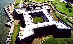
A presidio (English: jail, fortification) [1] was a fortified base established by the Spanish Empire between the 16th and 18th centuries in areas under their control or influence. The term is derived from the Latin word praesidium meaning protection or defense.
In the Mediterranean and the Philippines, the presidios were outposts of the Christian defense against Islamic raids. In the Americas, the fortresses were built to protect against raids by pirates, rival colonial powers, and Native Americans.
Later in western North America, with independence, the Mexicans garrisoned the Spanish presidios on the northern frontier and followed the same pattern in unsettled frontier regions such as the Presidio de Sonoma, at Sonoma, California, and the Presidio de Calabasas, in Arizona.
In western North America, a rancho del rey or king's ranch would be established a short distance outside a presidio. This was a tract of land assigned to the presidio to furnish pasturage to the horses and other beasts of burden of the garrison. Mexico called this facility "rancho nacional". [2] Presidios were only accessible to Spanish military and soldiers.
After the Granada War and the completion of the Spanish Reconquista , the Catholic Monarchs took their fight across the Strait of Gibraltar, as the Portuguese had done several generations earlier with the conquest of Ceuta in 1415. The establishment of Spanish military outposts on the North African coast echoed earlier endeavors by the Kingdom of Sicily in the 12th century (and again in Djerba under Frederick III of Sicily) and the Kingdom of France in the 13th century (Eighth Crusade of 1270). During the period of Iberian Union between 1580 and 1640, the Spanish Crown gained Ceuta and the Portuguese outposts on the Atlantic Coast, such as Tangier, Mazagão/El Jadida and Casablanca; but of these, it only retained Ceuta by the Treaty of Lisbon (1668).
The Spanish North African presidios are listed here in geographical sequence, from West to East, and including neither Spain's Atlantic settlements in the Moroccan far South (e.g. Santa Cruz de la Mar Pequeña) nor outposts gained after 1830 (e.g. the Chafarinas Islands).
Several fortresses formerly held by the Republic of Siena were acquired by Spain following the latter's demise, by treaty between Philip II of Spain and Cosimo I de' Medici, Grand Duke of Tuscany on 3 July 1557, to form what became known as the Estado de los Presidios. They were held by Spain until the War of the Spanish Succession, when they came under Austrian ownership, and were administered from Naples.
Few presidios were established in the present-day desert frontier regions in northern Mexico to control and confine the existing rebellious indigenous tribes. [3] Captured indigenous warriors were confined and enslaved at the presidio. [4] Presidios was used to protect the colonial silver ship from rebellious raids from Indians in Camino Real de Tierra Adentro, mainly in Zacatecas and Guanajuato, starting new settlements.
The Presidio of Monterey (POM), located in Monterey, California, is an active US Army installation with historic ties to the Spanish colonial era. Currently, it is the home of the Defense Language Institute Foreign Language Center (DLI-FLC). It is the last and only presidio in California to have an active military installation.
The Spanish Missions in Texas comprise a series of religious outposts established by Spanish Catholic Dominicans, Jesuits, and Franciscans to spread the Catholic doctrine among area Native Americans, but with the added benefit of giving Spain a toehold in the frontier land. The missions introduced European livestock, fruits, vegetables, and industry into the Texas area. In addition to the presidio and pueblo (town), the misión was one of the three major agencies employed by the Spanish crown to extend its borders and consolidate its colonial territories. In all, twenty-six missions were maintained for different lengths of time within the future boundaries of the state of Texas.
Jiménez is a town and seat of the municipality of Jiménez in the Mexican state of Coahuila, at an altitude of 250 meters above sea level. It is located on the confluence of the Río San Diego and the Rio Grande bordering with the U.S. state of Texas. It had a population of 1,160 inhabitants in the 2010 census, and is, unusually for a Mexican municipal seat, the second-largest locality in the municipality, after the town of San Carlos.
José Francisco Ortega was a New Spanish soldier and early settler of Alta California. He joined the military at the age of twenty-one and rose to the rank of sergeant by the time he joined the Portola expedition in 1769. At the end of his military duty he would be granted land which he named Rancho Nuestra Senora del Refugio near Santa Barbara.
José Antonio de la Guerra y Noriega was a Californio military officer, ranchero, and founder of the prominent Guerra family of California. He served as the Commandant of the Presidio of Santa Barbara and the Presidio of San Diego.
The Camino Real de Tierra Adentro, also known as the Silver Route, was a Spanish 2,560-kilometre-long (1,590 mi) road between Mexico City and San Juan Pueblo, New Mexico, that was used from 1598 to 1882. It was the northernmost of the four major "royal roads" that linked Mexico City to its major tributaries during and after the Spanish colonial era.
Almoloya de Juárez is a town in the State of Mexico and the seat of the municipality of Almoloya de Juárez. The name Almoloya comes from the Nahuatl, that is properly Almoloyan, composed of: atl, "water"; molo "impersonal voice of moloni, to flow the source" and yan, "place"; that it means "place where flows the water source".
The Presidio Santa María de Galve, founded in 1698 by Spanish colonists, was the first European settlement of Pensacola, Florida after that of Tristan de Luna in 1559–1561. It was in the area of Fort Barrancas at modern-day Naval Air Station Pensacola, in northwestern Florida. The presidio included Fort San Carlos de Austria and an adjacent village.
Beginning in the second half of the 16th century, the Kingdom of Spain established a number of missions throughout La Florida in order to convert the Native Americans to Roman Catholicism, to facilitate control of the area, and to obstruct regional colonization by other Protestants, particularly, those from England and France. Spanish Florida originally included much of what is now the Southeastern United States, although Spain never exercised long-term effective control over more than the northern part of what is now the State of Florida from present-day St. Augustine to the area around Tallahassee, southeastern Georgia, and some coastal settlements, such as Pensacola, Florida. A few short-lived missions were established in other locations, including Mission Santa Elena in present-day South Carolina, around the Florida peninsula, and in the interior of Georgia and Alabama.
The Spanish missions in South America comprise a series of Jesuit Catholic religious outposts established by Spanish Catholics in order to spread the Christian doctrine among the local natives.
Encarnación de Díaz is a town and municipality located in the far northeast of the state of Jalisco in north-central Mexico. It is located in a natural pass that connects the Los Altos region of Jalisco to points north, and from pre-Hispanic times until the 20th century, it was a major thoroughfare for north-south travel. The town began as a way station along a road built through this pass in the 17th century, formally becoming a town in 1760. It began to function as a municipality in the latter 19th century, but this status was not confirmed until the early 20th. Transport, along with numerous prosperous haciendas supported the economy of the area until the early 20th century, when travel patterns and the Mexican Revolution spurred its decline. In the 1920s, it was a centre of rebellion during the Cristero War, and the town contains Mexico's only museum exclusively dedicated to this episode in history. It also contains a museum dedicated to various naturally occurring mummies which have been found in the municipal cemetery.
Jiquipilco Municipality is one of the municipalities of the State of Mexico in Mexico. It is north of the Toluca Valley, part of the region consisting of the southern and western slopes of Cerro La Catedral, which has a concentration of speakers of the Otomi language. It is about 40 km from Toluca, the state capital. The name is a corruption of Nahuatl “Xiquipilco”, meaning “in the saddlebags”. Jiquipilco is situated on the transversal volcanic axis that crosses Mexico in an area surrounded by lakes and volcanoes. This portion is called "Anahuac”.
Ixtlahuaca de Rayón is the municipal seat and 5th largest city in the municipality of Ixtlahuaca north of Toluca in the northwest part of the State of Mexico, in Mexico. The distance between Mexico City and Ixtlahuaca is 32 km. The name Ixthahuaca comes from Náhuatl and means plains without trees. The city and municipality were officially established by decree on November 14, 1816 by the Congress of the State of Mexico.
The Ávila family was a prominent Californio family of Spanish origins from Southern California, founded by Cornelio Ávila in the 1780s. Numerous members of the family held important rancho grants and political positions, including two Alcaldes of Los Angeles.
Doña María Ygnacia López de Carrillo was a Californio ranchera. She was the founder of Santa Rosa. She married into the prominent Carrillo family of California and was the ancestor of numerous prominent Californians.
The Mexican Secularization Act of 1833, officially called the Decree for the Secularization of the Missions of California, was an act passed by the Congress of the Union of the First Mexican Republic which secularized the Californian missions. The act nationalized the missions, transferring their ownership from the Franciscan Order of the Catholic Church to the Mexican authorities.
The Cuernavaca Municipality is one of 36 municipalities in the State of Morelos, Mexico. Located in the northwest of the state, it consists of the City of Cuernavaca, which is the state and municipal capital, as well as other, smaller towns. The population is 378,476 (2020).
Spanish colonial authorities in North America established misiones, presidios and villas or pueblos. Official pueblo establishments were granted four square Spanish leagues of land and were required to be sited at least five Spanish leagues away from any other pueblo. According to one Arizona history, "Each organized pueblo was to have at least thirty inhabitants, each one to have ten breeding cows, four oxen, one brood mare, one sow, twenty Castillian ewes, six hens and one cock. House lots and sowing lands were to be distributed among pueblo settlers." Among the leadership of a pueblo was an alcalde.