
A presidio was a fortified base established by the Spanish Empire between the 16th and 18th centuries in areas under their control or influence. The term is derived from the Latin word praesidium meaning protection or defense.
Pedro Fages (1734–1794) was a Spanish soldier, explorer, first Lieutenant Governor of the province of the Californias under Gaspar de Portolá. Fages claimed the governorship after Portolá's departure, acting as governor in opposition to the official governor Felipe de Barri, and later served officially as fifth (1782–91) Governor of the Californias.

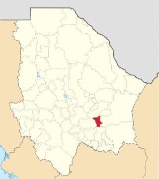
Santa Rosalía de Camargo, originally called Santa Rosalía, and now known as "Ciudad Camargo", is a city in the eastern part of the Mexican state of Chihuahua, located at the confluence of the Rio Parral and the Rio Conchos in the Allende Valley. It serves as the municipal seat of Camargo municipality and also serves as an important agricultural and livestock center for the area. Ciudad Camargo was originally founded in 1740 and refounded in 1792.

The Spanish Missions in Texas comprise a series of religious outposts established by Spanish Catholic Dominicans, Jesuits, and Franciscans to spread the Catholic doctrine among area Native Americans, but with the added benefit of giving Spain a toehold in the frontier land. The missions introduced European livestock, fruits, vegetables, and industry into the Texas area. In addition to the presidio and pueblo (town), the misión was one of the three major agencies employed by the Spanish crown to extend its borders and consolidate its colonial territories. In all, twenty-six missions were maintained for different lengths of time within the future boundaries of the state of Texas.
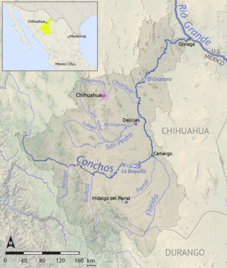
The Río Conchos is a large river in the Mexican state of Chihuahua. It joins the Río Bravo del Norte at the town of Ojinaga, Chihuahua.

The Portolá expedition was a Spanish voyage of exploration in 1769–1770 that was the first recorded European exploration of the interior of the present-day California. It was led by Gaspar de Portolá, governor of Las Californias, the Spanish colonial province that included California, Baja California, and other parts of present-day Mexico and the United States. The expedition led to the founding of Alta California and contributed to the solidification of Spanish territorial claims in the disputed and unexplored regions along the Pacific coast of North America.

José de Gálvez y Gallardo, 1st Marquess of Sonora was a Spanish lawyer and Visitador general in New Spain (1764–1772); later appointed to the Council of the Indies (1775–1787). He was one of the prime figures behind the Bourbon Reforms. He belonged to an important political family that included his brother Matías de Gálvez and nephew Bernardo de Gálvez.
Antonio de Espejo (1540–1585) was a Spanish explorer who led an expedition, accompanied by Diego Perez de Luxan, into New Mexico and Arizona in 1582–83. The expedition created interest in establishing a Spanish colony among the Pueblo Indians of the Rio Grande valley.
San Francisco de Conchos is one of the 67 municipalities of Chihuahua, in northern Mexico. The municipal seat lies at San Francisco de Conchos. The municipality covers an area of 1,169.1 km².
Pedro Meoqui is a city named after General Pedro Meoqui and is the seat of the municipality of Meoqui, in the northern Mexican state of Chihuahua. As of 2010, the municipality had a total population of 22,574, up from 21,306 as of 2005.
Santa Cruz de Rosales is a town and seat of the municipality of Rosales, in the northern Mexican state of Chihuahua. As of 2010, the town had a population of 5,570, up from 5,377 as of 2005

The City of San Antonio is one of the oldest Spanish settlements in Texas and was, for decades, its largest city. Before Spanish colonization, the site was occupied for thousands of years by varying cultures of indigenous peoples. The historic Payaya Indians were likely those who encountered the first Europeans.
The Chamuscado and Rodríguez Expedition visited the land on what became present day New Mexico in 1581–1582. The expedition was led by Francisco Sánchez, called "El Chamuscado," and Fray Agustín Rodríguez, the first Spaniards known to have visited the Pueblo Indians since Francisco Vásquez de Coronado 40 years earlier.
Antonio de San Buenaventura y Olivares or simply Fray Antonio de Olivares was a Spanish Franciscan who officiated at the first Catholic Mass celebrated in Texas, and he was known for contributing to the founding of San Antonio and to the prior exploration of the area. He founded, among other missions, the Alamo Mission in San Antonio, the Presidio San Antonio de Bexar, and the Acequia Madre de Valero.
Isidro Félix de Espinosa (1679–1755) was a Franciscan missionary from New Spain who participated in several expeditionary missions throughout the province of Tejas. He was the president of the missionaries from the College of Santa Cruz de Querétaro.
Don Pedro de Rábago y Terán was a Spanish administrator and military officer in New Spain, now Mexico. He was governor of Coahuila from August 1744 to June 1754. In 1754, Don Pedro de Rábago y Terán was sent by the viceroy of New Spain to find a site for an Apache Mission, named a pass between the hills in Menard County overlooking the San Saba River as Puerto de Baluartes. The Santa Cruz de San Sabá Mission was established three years later on the San Saba River near Menard, Texas. As an explorer in the late 1740s he went on three expeditions to the confluence of the Rio Grande and the Rio Conchos, known as La Junta de los Rios, in order to establish a presidio or military camp to serve six missions in the area of La Junta, which were being attacked by the Apache. He recommended a site that became the Presidio de la Junta de los Ríos Norte y Conchos near what is now Presidio, Texas.
Gregorio de Salinas Varona was a noble and Spanish administrator who served as governor in Texas, Coahuila, Nuevo Leon, Honduras and Pensacola. He was from Burgos and was descended from a noble family of civil servants with roots in the towns of Salinas de Rosío and Medina de Pomar.

This timeline of the Portolá expedition tracks the progress during 1769 and 1770 of the first European exploration-by-land of north-western coastal areas in what became Las Californias, a province of Spanish colonial New Spain. Later, the region was administratively-split into Baja and Alta. The first section of the march was on the Baja California peninsula, and the northern section of the expedition's trail was in today's US state of California.

