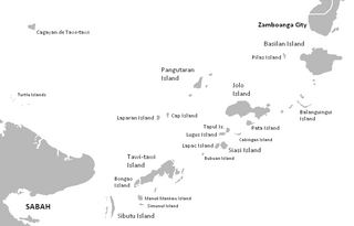
The Sulu Archipelago is a chain of islands in the Pacific Ocean, in the southwestern Philippines. The archipelago forms the northern limit of the Celebes Sea and southern limit of the Sulu Sea. The Sulu Archipelago islands are within the Mindanao island group, consisting of the provinces of Basilan, Sulu, and Tawi-Tawi; hence the archipelago is sometimes referred to as Basulta, derived from the first syllables of the three provinces.

Iloilo, officially the Province of Iloilo, is a province in the Philippines located in the Western Visayas region. Its capital and largest city is Iloilo City, the regional center of Western Visayas. Iloilo occupies a major southeast portion of the Visayan island of Panay and is bordered by the province of Antique to the west, Capiz to the north, the Jintotolo Channel to the northeast, the Guimaras Strait to the east, and the Iloilo Strait and Panay Gulf to the southwest.

Isabela, officially the City of Isabela, is a 4th class Independent component city and de facto capital of the province of Basilan, Philippines. According to the 2020 census, it has a population of 130,379 people.

A presidio was a fortified base established by the Spanish Empire between the 16th and 18th centuries in areas in of their control or influence. The term is derived from the Latin word praesidium meaning protection or defense.

Bantayan, officially the Municipality of Bantayan, is a 1st class municipality in the province of Cebu, Philippines. According to the 2020 census, it has a population of 86,247 people, making it the island's most populous town as well as the largest.

Fort San Pedro is a military defense structure in Cebu, Philippines, built by the Spanish under the command of Miguel López de Legazpi, first governor of the Captaincy General of the Philippines. It is located in the area now called Plaza Independencia, in the pier area of the city. The original fort was made of wood and built after the arrival of Legazpi and his expedition. In the early 17th century a stone fort was built to repel Muslim raiders. Today's structure dates from 1738 and is the oldest triangular bastion fort in the country. It served as the nucleus of the first Spanish settlement in the Philippines. During the Philippine Revolution at the end of the 19th century, it was attacked and taken by Filipino revolutionaries, who used it as a stronghold.

Madridejos, officially the Municipality of Madridejos, is a 4th class municipality in the province of Cebu, Philippines. According to the 2020 census, it has a population of 42,039 people.

Bantayan Island is an island located in the Visayan Sea, Philippines. It is situated to the west of the northern end of Cebu island, across the Tañon Strait. According to the 2015 census, it has a population of 145,436.

Juan Cerezo de Salamanca was interim Spanish governor of the Philippines from August 2, 1633 to June 25, 1635.
The architecture of the Philippines reflects the historical and cultural traditions in the country. Most prominent historic structures in the archipelago are influenced by Austronesian, American architectures.

The Real Fuerte de Nuestra Señora del Pilar de Zaragoza, also Fort Pilar, is a 17th-century military defense fortress built by the Spanish colonial government in Zamboanga City. The fort, which is now a regional museum of the National Museum of the Philippines, is a major landmark of the city and it symbolize the cultural heritage.
Basilan is an island province of the Philippines. It is the largest and northernmost of the major islands of the Sulu Archipelago and is located just off the southern coast of Zamboanga Peninsula. Its capital is Lamitan. Basilan is home to three main ethnic groups, the indigenous Yakans, and the later-arriving Tausugs and Zamboangueños. The Yakans and Tausugs are predomimantly Muslim, while the Chavacanos are mainly Christian. There are also a number of smaller groups.

The Spanish forts of the Philippines, or fuerzas, are strongholds constructed by Filipinos and Spaniards primarily for protection against local and foreign aggressors during the Spanish colonial period, and during the subsequent American and Japanese occupations. Many are badly damaged, either due to old age or past conflicts. Currently, there are initiatives for restorations of all forts, beginning when the Baluarte Luna of La Union and the Intramuros of Manila were restored in the 2010s. In 2013, a typhoon and earthquake hit Central Visayas and damaged numerous Spanish fortifications, leading to the largest restoration activity for fortifications in Philippine history.

The Spanish–Moro conflict was a series of battles in the Philippines lasting over several centuries. It began during the Spanish Philippines and lasted until the Spanish–American War, when Spain finally began to subjugate the Moro people after centuries of attempts to do so. Spain ultimately conquered portions of the Mindanao and Jolo islands and turned the Sultanate of Sulu into a protectorate, establishing geographic dominance over the region until the Spanish-American War. Moro resistance continued.

Gabriel Lázaro de Mangubat, also known as Capitán Loreto Mangubat, was a Visayan Filipino conquistador, Spanish nobleman, and armiger of Spanish Heraldic shield from the early 17th century.
Tanguingui is a small, uninhabited island in the Visayan Sea of the Philippines. The island is under the jurisdiction of the municipality of Madridejos, Cebu. There is a lighthouse on the island.
Singhapala was an ancient fortified city or a region, the capital of the Indianized Rajahnate of Cebu. The location of this ancient city is what is now the modern Barangay Mabolo in the northern district of Cebu City. Founded by Sri Lumay or Raja Muda Lumaya, a half-Tamil prince.

Lanong were large outrigger warships used by the Iranun and the Banguingui people of the Philippines. They could reach up to 30 m (98 ft) in length and had two biped shear masts which doubled as boarding ladders. They also had one to three banks of oars rowed by galley slaves. They were specialized for naval battles. They were prominently used for piracy and slave raids from the mid-18th century to the early 19th century in most of Southeast Asia. The name lanong is derived from Lanun, an exonym of the Iranun people.
Dapitan Kingdom is the term used by local historians of Bohol, Philippines, to refer to the Dauis–Mansasa polity in the modern city of Tagbilaran and the adjecent island of Panglao. The volume of artifacts unearthed in the sites of Dauis and Mansasa may have inspired the creation of the legend of the "Dapitan Kingdom" through piecing together the oral legends of the Eskaya people and historical events such as the Ternatan raid of Bohol and the migration of Boholanos under Datu Pagbuaya to Dapitan.

The Romblon Cathedral, officially the Saint Joseph Cathedral Parish, is a Roman Catholic cathedral in Romblon town, in the province of Romblon, Philippines. One of the province's known landmarks, it is the seat of the Roman Catholic Diocese of Romblon and was declared a National Cultural Treasure in 2001 by the National Museum of the Philippines.

