Parris Island, South Carolina

Last updated

Parris Island, South Carolina
District
1882 U.S. Coast Survey Map of Beaufort, South Carolina - Geographicus - Beaufort-uscs-1882.jpg
1882 U.S. Coast Survey Map of Beaufort River, showing the island (at left) designated "Paris I."
SCMap-doton-ParrisIsland.PNG
Location of Parris Island, South Carolina
Coordinates: 32°19′44″N80°41′41″W / 32.32889°N 80.69472°W / 32.32889; -80.69472
Country United States
State South Carolina
County Beaufort
Area
  Total19.6 sq mi (51 km2)
  Land12.2 sq mi (32 km2)
  Water7.4 sq mi (19 km2)
Population
 (2000)
  Total4,841
  Density250/sq mi (95/km2)
Time zone UTC-5 (Eastern (EST))
  Summer (DST) UTC-4 (EDT)
ZIP codes
29902, 29905
Area code(s) 843, 854
FIPS code 45-54850 [1]

Parris Island is a district of the city of Port Royal, South Carolina on an island of the same name. It became part of the city with the annexation of the Marine Corps Recruit Depot Parris Island on October 11, 2002. For statistical purposes, the United States Census Bureau previously defined Parris Island as a census-designated place (CDP) when it was an unincorporated area of Beaufort County. The population was 4,841 at the 2000 census. As defined by the U.S. Census Bureau, Parris Island is included within the Beaufort Urban Cluster and the larger Hilton Head Island Beaufort Micropolitan Statistical Area. [2]

Contents

History

Parris Island was first colonized by Europeans in 1562, when members of a French expedition led by Jean Ribaut temporarily settled on the island. This was the first semi-permanent European settlement in what are now considered the United States. Four years later, a town named Santa Elena was founded here by Spanish Conquistador Pedro Menéndez de Avilés. It was the capital of La Florida from 1566 to 1587, during which time Spanish explorers sailed from Santa Elena to explore the Tennessee Valley and Chesapeake Bay. An expedition also traveled overland into the interior to western North Carolina and points west.

After coming under English control, the island was granted to Robert Daniell in 1706 and became known as Port Royal Island. It later came into the hands of Colonel Alexander Parris, sometimes spelled "Paris", Public Treasurer of South Carolina. After his death in 1736, it gradually became known as Parris Island (and the name Port Royal Island was applied to a different one to the north). [3] [4] [5]

Parris Island was captured by the Union Army in 1861 during the American Civil War. It became a coaling station during the war. After the war, through the efforts of African American Congressman Robert Smalls, it continued as a coaling station for the United States Navy and became known as the Port Royal Naval Station. The neighboring Port Royal Sound is the deepest natural harbor on the Atlantic coast of the United States south of New York. The island was purchased outright in 1883. In the early 1890s, a dry dock was constructed at the naval station. The dry dock was completed in 1895. The construction of the Charleston Naval Shipyard in 1901 resulted in the closing of the Port Royal Naval Station in 1903. [6]

In 1915, Parris Island became the Marine Corps Recruit Depot. In the early years of the Marine Corps presence it was referred to as Paris Island. [7]

The Charlesfort-Santa Elena Site and Parris Island Drydock and Commanding Generals House are listed on the National Register of Historic Places. [8]

Geography

According to the United States Census Bureau, the CDP had a total area of 19.6 square miles (51 km2), of which 12.2 square miles (32 km2) of it is land and 7.4 square miles (19 km2) of it (37.96%) is water.

Demographics

As of the census [1] of 2000, there were 4,841 people, 318 households, and 297 families residing in the CDP. The population density was 398.0 inhabitants per square mile (153.7/km2). There were 358 housing units at an average density of 29.4 per square mile (11.4/km2). The racial makeup of the CDP was 69.14% White, 17.35% African American, 0.83% Native American, 1.76% Asian, 0.12% Pacific Islander, 7.13% from other races, and 3.68% from two or more races. Hispanic or Latino of any race were 13.16% of the population.

There were 318 households, out of which 72.3% had children under the age of 18 living with them, 87.7% were married couples living together, 4.4% had a female householder with no husband present, and 6.3% were non-families. 4.4% of all households were made up of individuals, and none had someone living alone who was 65 years of age or older. The average household size was 3.31 and the average family size was 3.40.

In the CDP, the population was spread out, with 10.6% under the age of 18, 72.4% from 18 to 24, 15.7% from 25 to 44, and 1.2% from 45 to 64. The median age was 20 years. For every 100 females, there were 303.8 males. For every 100 females age 18 and over, there were 339.3 males.

The median income for a household in the CDP was $46,335, and the median income for a family was $45,750. Males had a median income of $17,428 versus $16,359 for females. The per capita income for the CDP was $11,216. About 7.6% of families and 6.9% of the population were below the poverty line, including 4.1% of those under age 18 and none of those age 65 or over.

Parris Island was the setting for the first half of Stanley Kubrick's 1987 war film Full Metal Jacket , as well as the scene of several flashbacks in the TV series Revolution . [9] [10] It is also mentioned in the opening lines of the song "Goodnight Saigon" by Billy Joel.

See also

Related Research Articles

<span class="mw-page-title-main">Jasper County, South Carolina</span> County in South Carolina, United States

Jasper County is the southernmost county in the U.S. state of South Carolina. As of the 2020 census, the population was 28,791. Its county seat is Ridgeland and its largest community is Hardeeville. The county was formed in 1912 from portions of Hampton County and Beaufort County.

<span class="mw-page-title-main">Beaufort County, South Carolina</span> County in South Carolina, United States

Beaufort County is a county in the U.S. state of South Carolina. As of the 2020 census, its population was 187,117. Its county seat is Beaufort and its largest community is Hilton Head Island.

<span class="mw-page-title-main">Iroquois Point, Hawaii</span> Census-designated place in Hawaii, United States

Iroquois Point is a census-designated place (CDP) in Honolulu County, Hawaii, United States, on the island of Oahu near Pearl Harbor. The population was 4,549 at the 2020 census. "Iroquois Point" refers to the geographic land area that is occupied by the Kapilina Beach Homes, a firing range, a Navy Exchange shoppette and gas station, and Iroquois Point Elementary School. Once primarily used as a military housing community, it is now privately operated.

<span class="mw-page-title-main">Brunswick Station, Maine</span> Census-designated place in Maine, United States

Brunswick Station was a census-designated place (CDP) within the town of Brunswick in Cumberland County, Maine, United States. The population was 578 at the 2010 census. It consists of an area that was part of the former Naval Air Station Brunswick and was part of the Portland–South Portland–Biddeford, Maine Metropolitan Statistical Area. The 2020 census shows it as part of the Brunswick CDP.

<span class="mw-page-title-main">Medford, New York</span> Hamlet & census-designated place in New York, United States

Medford is a hamlet and census-designated place (CDP) in the Town of Brookhaven in Suffolk County, on Long Island, in New York, United States. The population was 24,247 at the 2020 census.

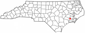
River Road is a census-designated place (CDP) in Beaufort County, North Carolina, United States. The population was 4,048 at the 2020 Census.

<span class="mw-page-title-main">Newport, North Carolina</span> Town in North Carolina, United States

Newport is a town in Carteret County, North Carolina, United States. The population was 4,510 at the 2010 census.

Lake Norman of Catawba is a census-designated place (CDP) in Catawba County, North Carolina, United States. The population was 11,395 at the 2020 census up from 7,411 at the 2010 census. It is part of the Hickory-Lenoir-Morganton Metropolitan Statistical Area.

<span class="mw-page-title-main">Neuse Forest, North Carolina</span> Census-designated place in North Carolina, United States

Neuse Forest is a census-designated place (CDP) in Craven County, North Carolina, United States. The population was 2,005 at the 2010 census. It is part of the New Bern, North Carolina Metropolitan Statistical Area.

<span class="mw-page-title-main">Beaufort, South Carolina</span> City in South Carolina, United States

Beaufort is a city in and the county seat of Beaufort County, South Carolina, United States. Chartered in 1711, it is the second-oldest city in South Carolina, behind Charleston. Beaufort is known as the "Queen of the Carolina Sea Islands". The city's population was 13,607 at the 2020 census. It is part of the Hilton Head Island–Bluffton metropolitan area.

<span class="mw-page-title-main">Burton, South Carolina</span> CDP in South Carolina, United States

Burton is a census-designated place (CDP) on Port Royal Island in Beaufort County, South Carolina, United States. The population was 6,976 at the 2010 census. As defined by the U.S. Census Bureau, Burton is included within the Hilton Head Island-Bluffton-Beaufort, SC Metropolitan Statistical Area.

<span class="mw-page-title-main">Laurel Bay, South Carolina</span> CDP in South Carolina, United States

Laurel Bay is a census-designated place and military housing complex in Beaufort County, South Carolina, United States. The population was 5,891 at the 2010 census. As defined by the U.S. Census Bureau, Laurel Bay is included within the Hilton Head Island-Bluffton-Beaufort, SC Metropolitan Statistical Area.

<span class="mw-page-title-main">Port Royal, South Carolina</span> Town in South Carolina, United States

Port Royal is a town on Port Royal Island in Beaufort County, South Carolina, United States. The population was 14,220 at the 2020 census. It is part of the Hilton Head Island–Bluffton metropolitan area. Port Royal is home to Marine Corps Recruit Depot Parris Island and United States Naval Hospital Beaufort.

<span class="mw-page-title-main">Shell Point, South Carolina</span> CDP in South Carolina, United States

Shell Point is a census-designated place (CDP) in Beaufort County, South Carolina, United States. The population was 2,336 at the 2010 census. As defined by the U.S. Census Bureau, Shell Point is in the Hilton Head Island−Bluffton, SC Metropolitan Statistical Area.

<span class="mw-page-title-main">Bucksport, South Carolina</span> Census-designated place in South Carolina, United States

Bucksport is an unincorporated community and census-designated place (CDP) in Horry County, South Carolina, United States. The population was 876 at the 2010 census. It is a rural port on the Atlantic Intracoastal Waterway at the merger point with the Waccamaw River. The port has some services available for boaters and is also home to the Bucksport Restaurant.

<span class="mw-page-title-main">Socastee, South Carolina</span> CDP in South Carolina, United States

Socastee is a census-designated place (CDP) in Horry County, South Carolina, United States. The population was 19,952 at the 2010 census.

<span class="mw-page-title-main">Lugoff, South Carolina</span> Census-designated place in South Carolina, United States

Lugoff is an unincorporated community and census-designated place (CDP) in Kershaw County, South Carolina, United States. The population was 9,990 at the 2020 census, up from 7,434 at the 2010 census. It is part of the Columbia, South Carolina Metropolitan Statistical Area.

<span class="mw-page-title-main">Dentsville, South Carolina</span> Census-designated place in South Carolina, United States

Dentsville is a census-designated place (CDP) in Richland County, South Carolina, United States. The population was 14,062 at the 2010 census. It is part of the Columbia, South Carolina, Metropolitan Statistical Area.

<span class="mw-page-title-main">Port Mansfield, Texas</span> CDP in Texas, United States

Port Mansfield is a census-designated place (CDP) in Willacy County, Texas, United States. The population was 226 at the 2010 census.

<span class="mw-page-title-main">Yemassee, South Carolina</span> Town in South Carolina, United States

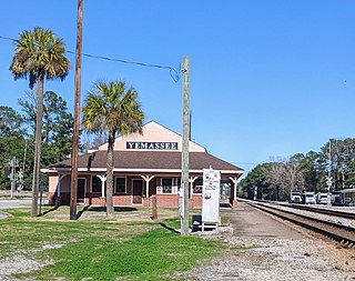
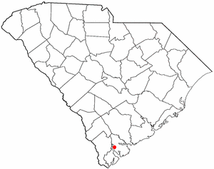
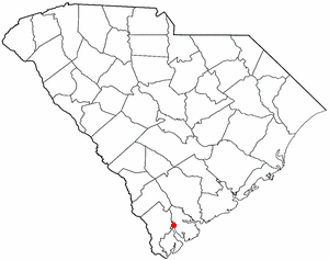
Yemassee is a small Lowcountry town in Beaufort and Hampton counties in the U.S. state of South Carolina. The population was 1,027 at the 2010 census. Yemassee is near the borders of Colleton and Jasper counties. The town is divided by the county line between Beaufort and Hampton counties, which follows the roadbed of the CSX railroad. Most of the town's population presently lies within Hampton County. As defined by the U.S. Census Bureau, the Beaufort County portion of Yemassee is included within the Hilton Head Island-Bluffton-Beaufort, SC Metropolitan Statistical Area. Yemassee hosts one of the few commercial breeding facilities of non-human primates in the entire United States, Alpha Genesis, Inc., which serves as a major employer for the town. Also, the Frank Lloyd Wright-designed Auldbrass Plantation house and outbuildings lie just outside the town limits of Yemassee.

References

  1. 1 2 "U.S. Census website". United States Census Bureau . Retrieved January 31, 2008.
  2. Population Estimates Boundary Changes, United States Census Bureau, 2007-07-01. Accessed 2008-11-06.
  3. Alexander Samuel Salley (1919). Parris Island, the Site of the First Attempt at a Settlement of White People Within the Bounds of what is Now South Carolina. The Commission. pp. 8–11.
  4. Tryals for High-treason, and Other Crimes: Vol VIII. London: Thomas Wotton. 1731. p. 337. Retrieved November 5, 2019.
  5. McCord, David J, ed. (1840). The Statutes at Large of South Carolina: Vol 7. Columbia SC. p. 26. Retrieved November 5, 2019.
  6. Rowland, Lawrence S. (August 22, 2022). "Port Royal Naval Station". South Carolina Encyclopedia. Institute for Southern Studies, University of South Carolina. Retrieved December 15, 2023.
  7. The Navy Register. Washington DC: Bureau of Naval Personnel. January 1, 1919. pp. 817, 853. Retrieved November 4, 2019.
  8. "National Register Information System". National Register of Historic Places . National Park Service. July 9, 2010.
  9. Full Metal Jacket (1987) - Filming & production - IMDb , retrieved August 17, 2023
  10. Rome, Emily. "Revolution recap: The Birth of a Militia". Entertainment Weekly. Entertainment Weekly. Retrieved November 22, 2016.