Notable earthquakes in the history of El Salvador include the following:
| Date | Location | Mag. | MMI | Deaths | Injuries | Notes | ||
|---|---|---|---|---|---|---|---|---|
| 2023-01-15 | Ahuachapán | 5.2 Mw | VII | 4 | Severe damage | [1] [2] [3] | ||
| 2019-05-30 | La Libertad | 6.6 Mw | VI | 1 | 1 | [4] | ||
| 2018-05-06 | La Unión | 5.4 Mw | VI | 1 | Moderate damage | [5] | ||
| 2017-04-01 | La Libertad | 5.1 Mw | VI | 1 | ||||
| 2016-11-24 | San Vicente | 6.9 Mw | IV | 1 | Death caused by heart attack | [6] [7] | ||
| 2015-08-09 | Usulután | 4.5 Mw | V | 4 | Moderate damage | [8] | ||
| 2014-10-14 | La Unión | 7.3 Mw | VII | 4 | Several | Severe damage | [9] | |
| 2012-08-27 | Usulután | 7.3 Mw | V | 0 | 40+ | Major tsunami, over 6 meters | ||
| 2001-05-08 | San Vicente | 5.7 Mw | VI | 1 | Moderate damage | [10] | ||
| 2001-02-13 | La Paz | 6.6 Mw | VIII | 315 | Severe damage | |||
| 2001-01-13 | Usulután | 7.7 Mw | IX | 944 | 5,565 | Severe damage, Major landslide | ||
| 1987-01-15 | La Libertad | 4.0 Mw | IV | Severe damage | [11] | |||
| 1986-10-10 | San Salvador | 4.6 Mw | V | Additional damage | [12] | |||
| 1986-10-10 | San Salvador | 5.7 Mw | IX | 1,000–3,000 | 10,000–20,000 | Extreme damage | ||
| 1982-06-19 | Usulután | 7.3 Mw | VII | 43 | $5 million damage | |||
| 1965-05-03 | San Salvador | 5.9 Mw | VIII | 125 | 500 | [13] | ||
| 1951-05-06 | Usulután, La Paz | 6.2 Ms | 400–1,100 | [13] | ||||
| 1936-12-19 | San Vicente | 6.1 | VII | 200 | [14] | |||
| 1919-04-28 | San Salvador | 5.9 | VII | 100 | [14] | |||
| 1917-06-07 | La Libertad | 6.2–6.5 | VIII | 1,050 | Severe damage | [14] | ||
| 1873-03-19 | San Salvador | 7.3 | 57 | [14] | ||||
| 1859-08-12 | La Libertad | 7.3 | VII | Severe damage | [14] | |||
| 1831-02-07 | San Salvador | 7.1 | [14] | |||||
| 1783-11-29 | San Vicente | 7.6 | [14] | |||||
| 1776-05-30 | San Salvador | 7.5 | [14] | |||||
| 1719-06-03 | San Salvador | 7.0 | 7 | [14] | ||||
| 1625 | San Salvador | IX | Severe damage | [14] | ||||
| 1594-04-21 | San Salvador | 13 | [14] | |||||
| 1575-05-23 | San Salvador | 3 | Severe damage | [14] | ||||
| The inclusion criteria for adding events are based on WikiProject Earthquakes' notability guideline that was developed for stand alone articles. The principles described are also applicable to lists. In summary, only damaging, injurious, or deadly events should be recorded. | ||||||||
The 1982 El Salvador earthquake occurred southeast of San Salvador on 19 June at 00:21 local time. This undersea earthquake struck offshore in the Pacific Ocean and had a surface wave magnitude of 7.3 and a maximum Mercalli intensity of VII. Occurring adjacent to a subduction zone at the Middle America Trench, this normal-slip shock left at least 16 and as many as 43 people dead, and many injured, and also inflicted $5 million in damage.
The 1960 Concepción earthquakes were a succession of three destructive earthquakes that happened between 21 and 22 May 1960. They formed part of the foreshock sequence for the 1960 Valdivia earthquake, the largest recorded earthquake in history.
The 2012 Guerrero–Oaxaca earthquake struck southern Mexico with a moment magnitude of 7.4 at 12:02 local time on Tuesday, 20 March. Its epicenter was near Ometepec, in the border between the states of Guerrero and Oaxaca. With a shallow focus of 20 km, the earthquake caused strong shaking over a large area along the Oaxaca–Guerrero border and the adjacent Pacific coastline. Significant tremors were felt in areas up to several hundred kilometers away, including Mexico City and also in Guatemala. Two people were killed and over 30,000 houses were damaged or destroyed.
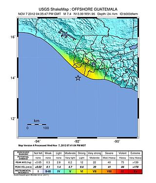
The 2012 Guatemala earthquake occurred on November 7 at 10:35:45 local time. The shock had a moment magnitude of 7.4 and a maximum Mercalli Intensity of VII. The epicenter was located in the Pacific Ocean, 35 kilometres (22 mi) south of Champerico in the department of Retalhuleu. The affected region is earthquake-prone, where the Cocos Plate is being subducted along the Middle America Trench beneath the North American and the Caribbean Plates, near their triple junction.
The 1625 El Salvador earthquake struck El Salvador in 1625. Described as a "violent earthquake that caused serious damage", it affected the city of San Salvador, and left it in ruins. Surrounding pueblos were also affected.

The 2019 Coquimbo earthquake occurred 10 km south southwest of Coquimbo in Chile, on January 19, 2019 at 22:32. The epicenter was located off the coast of the Coquimbo Region at a depth of 63.0 km,) and had a moment magnitude of 6.7. On the Mercalli scale, the earthquake reached an intensity of VIII.
A moment magnitude Mw 7.0 or 7.1 earthquake occurred near the city of Acapulco in the Mexican state of Guerrero at 20:47 local time on 7 September with an estimated intensity of VIII (Severe) on the MMI scale. The earthquake killed 13 people and injured at least 23 others. At least 1.6 million people in Mexico were affected by the earthquake which resulted in localized severe damage. The earthquake occurred on the anniversary of the 2017 Chiapas earthquake which measured Mw 8.2. It was also the largest earthquake in Mexico since the 2020 Oaxaca earthquake.

A major earthquake struck northern Peru on November 28, 2021, 5:52 a.m. local time with a magnitude of 7.5 on the moment magnitude scale between the Amazonas and Loreto departments of Peru. A maximum Modified Mercalli intensity (MMI) of VII was reported in the town of Santa Maria de Nieva according to the Geological Institute of Peru.

On 19 September 2022, a moment magnitude 7.6-7.7 earthquake struck between the Mexican states of Michoacán and Colima at 13:05:06 local time. The earthquake had a depth of 26.9 km (16.7 mi), resulting in a maximum intensity of VIII (Severe) on the Modified Mercalli intensity scale. The USGS reported the epicentre was 35 km (22 mi) southwest of the town of Aquila. Two people were killed and at least 35 others were injured across several states. A magnitude 6.8 aftershock struck on 22 September, causing three more deaths.
On 23 May 1575, a telluric earthquake struck the city of San Salvador in the Spanish colony of New Spain. The earthquake destroyed the city. The earthquake was the second earthquake recorded with its epicenter in modern-day El Salvador, after the 1524 San Salvador earthquake.
| Authority control databases: National |
|---|