Highways


- Dwight D. Eisenhower System of Interstate and Defence Highways
- Eisenhower Parkway in Essex County, New Jersey
- Eisenhower Expressway (Interstate 290) near Chicago
- Eisenhower Tunnel on Interstate 70 west of Denver
This is a list of places in the United States named for Dwight D. Eisenhower:
Colleges and universities named after Dwight D. Eisenhower

Dwight David Eisenhower, nicknamed Ike, was an American military officer and statesman who served as the 34th president of the United States from 1953 to 1961. During World War II, he served as Supreme Commander of the Allied Expeditionary Force in Europe and achieved the five-star rank as General of the Army. Eisenhower planned and supervised two of the most consequential military campaigns of World War II: Operation Torch in the North Africa campaign in 1942–1943 and the D-Day invasion of Normandy in 1944.

Kansas is a state in the Midwestern United States. Its capital is Topeka, and its most populous city is Wichita. Kansas is a landlocked state bordered by Nebraska to the north; Missouri to the east; Oklahoma to the south; and Colorado to the west. Kansas is named after the Kansas River, which in turn was named after the Kansa Native Americans who lived along its banks. For thousands of years, what is now Kansas was home to numerous and diverse Native American tribes. Tribes in the eastern part of the state generally lived in villages along the river valleys. Tribes in the western part of the state were semi-nomadic and hunted large herds of bison.

Interstate 25 (I-25), also known as the Pan-America Freeway, is a major Interstate Highway in the western United States. It is primarily a north–south highway, serving as the main route through New Mexico, Colorado, and Wyoming. I-25 stretches from I-10 at Las Cruces, New Mexico to I-90 in Buffalo, Wyoming. It passes through or near Albuquerque, New Mexico; Pueblo, Colorado; Colorado Springs, Colorado; Denver, Colorado; Fort Collins, Colorado; and Cheyenne, Wyoming. The I-25 corridor is mainly rural, especially in Wyoming, excluding the Albuquerque, Pueblo, Colorado Springs, Denver, and Fort Collins metropolitan areas.

Interstate 70 (I-70) is a major east–west Interstate Highway in the United States that runs from I-15 near Cove Fort, Utah, to I-695 and Maryland Route 570 in Woodlawn, just outside Baltimore, Maryland. I-70 approximately traces the path of U.S. Route 40 east of the Rocky Mountains. West of the Rockies, the route of I-70 was derived from multiple sources. The Interstate runs through or near many major cities, including Denver, Topeka, Kansas City, St. Louis, Indianapolis, Columbus, Pittsburgh, and Baltimore. The sections of the Interstate in Missouri and Kansas have laid claim to be the first Interstate in the United States. The Federal Highway Administration (FHWA) has claimed the section of I-70 through Glenwood Canyon, Colorado, completed in 1992, to be the last piece of the Interstate Highway System, as originally planned, to open to traffic. The construction of I-70 in Colorado and Utah is considered an engineering marvel, as the route passes through the Eisenhower Tunnel, Glenwood Canyon, and the San Rafael Swell. The Eisenhower Tunnel is the highest point along the Interstate Highway System, with an elevation of 11,158 feet (3,401 m).

Sedgwick County is located in the U.S. state of Kansas. Its county seat is Wichita, the most populous city in the state. As of the 2020 census, the population was 523,824, making it the second-most populous county in Kansas. The county was named for John Sedgwick, the highest ranking Union general killed during the American Civil War.

Abilene is a city in, and the county seat of, Dickinson County, Kansas, United States. As of the 2020 census, the population of the city was 6,460. It is home of The Dwight D. Eisenhower Presidential Library and Museum and the Greyhound Hall of Fame.

Wichita is the most populous city in the U.S. state of Kansas and the county seat of Sedgwick County. As of the 2020 census, the population of the city was 397,532. The Wichita metro area had a population of 647,610 in 2020. It is located in south-central Kansas on the Arkansas River.
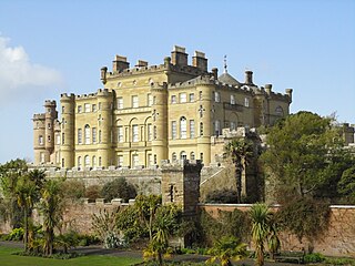
Culzean Castle is a castle overlooking the Firth of Clyde, near Maybole, Carrick, in South Ayrshire, on the west coast of Scotland. It is the former home of the Marquess of Ailsa, the chief of Clan Kennedy, but is now owned by the National Trust for Scotland. The clifftop castle lies within the Culzean Castle Country Park and is opened to the public. From 1972 until 2015, an illustration of the castle was featured on the reverse side of five pound notes issued by the Royal Bank of Scotland.

U.S. Route 54 is an east–west United States Highway that runs northeast–southwest for 1,197 miles (1,926 km) from El Paso, Texas, to Griggsville, Illinois. The Union Pacific Railroad's Tucumcari Line runs parallel to US 54 from El Paso to Pratt, Kansas, which comprises about two-thirds of the route.

The following is an alphabetical list of articles related to the U.S. state of Kansas.

Wichita Dwight D. Eisenhower National Airport is a commercial airport 7 miles (11 km) west of downtown Wichita, Kansas, United States. It is the largest and busiest airport in the state of Kansas. Located south of US-54 in southwest Wichita, it covers 3,248 acres and contains three runways.
The Dwight D. Eisenhower Presidential Library, Museum and Boyhood Home is the presidential library and museum of Dwight David Eisenhower, the 34th president of the United States (1953–1961), located in his hometown of Abilene, Kansas. The museum includes Eisenhower's boyhood home, where he lived from 1898 until being appointed to West Point in 1911, and is also the president's final resting place. It is one of the thirteen presidential libraries under the auspices of the National Archives and Records Administration (NARA).

Harry Darby was an American politician from Kansas.
The Fort Worth and Denver Railway, nicknamed "the Denver Road", was a class I American railroad company that operated in the northern part of Texas from 1881 to 1982, and had a profound influence on the early settlement and economic development of the region.
In the US state of Colorado, Interstate 25 (I-25) follows the north–south corridor through Colorado Springs and Denver. The highway enters the state from the north near Carr and exits the state near Starkville. The highway also runs through the cities of Fort Collins, Broomfield, Loveland, and Pueblo. The route is concurrent with U.S. Route 87 (US 87), which is unsigned, through the entire length of the state. I-25 replaced US 87 and most of US 85 for through traffic.
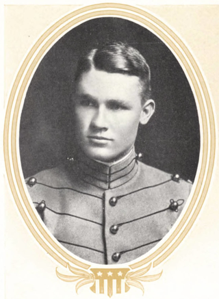
Paul Alfred Hodgson was a West Point graduate who served in World War I and World War II. While at West Point, he roomed with the future President of the United States, Dwight D. Eisenhower. The two enjoyed a lifelong friendship through their military career and their enjoyment for sports.
U.S. Route 54 is a part of the U.S. Highway System that runs from El Paso, Texas, to Interstate 72 (I-72) in Griggsville, Illinois. In the U.S. state of Kansas, US 54 is a main east–west highway that runs from the Oklahoma border east to the Missouri border.
Westport Airport is a privately owned, public use airport located three nautical miles (6 km) southwest of the central business district of Wichita, a city in Sedgwick County, Kansas, United States. It is in the Class C airspace of neighboring Wichita Dwight D. Eisenhower National Airport.
The following is a timeline of the history of the city of Wichita, Kansas, USA.