Related Research Articles

Asia is the largest continent in the world by both land area and population. It covers an area of more than 44 million square kilometers, about 30% of Earth's total land area and 8% of Earth's total surface area. The continent, which has long been home to the majority of the human population, was the site of many of the first civilizations. Its 4.7 billion people constitute roughly 60% of the world's population.

India is situated north of the equator between 8°4' north to 37°6' north latitude and 68°7' east to 97°25' east longitude. It is the seventh-largest country in the world, with a total area of 3,287,263 square kilometres (1,269,219 sq mi). India measures 3,214 km (1,997 mi) from north to south and 2,933 km (1,822 mi) from east to west. It has a land frontier of 15,200 km (9,445 mi) and a coastline of 7,516.6 km (4,671 mi).

Kashmir is the northernmost geographical region of the Indian subcontinent. Until the mid-19th century, the term "Kashmir" denoted only the Kashmir Valley between the Great Himalayas and the Pir Panjal Range. Today, the term encompasses a larger area that includes the India-administered territories of Jammu and Kashmir and Ladakh, the Pakistan-administered territories of Azad Kashmir and Gilgit-Baltistan, and the Chinese-administered territories of Aksai Chin and the Trans-Karakoram Tract.

The Himalayas, or Himalaya, is a mountain range in Asia, separating the plains of the Indian subcontinent from the Tibetan Plateau. The range has some of the Earth's highest peaks, including the highest, Mount Everest; more than 100 peaks exceeding elevations of 7,200 m (23,600 ft) above sea level lie in the Himalayas.

The Hindu Kush is an 800-kilometre-long (500 mi) mountain range on the Iranian Plateau in Central and South Asia to the west of the Himalayas. It stretches from central and eastern Afghanistan into northwestern Pakistan and far southeastern Tajikistan. The range forms the western section of the Hindu Kush Himalayan Region (HKH); to the north, near its northeastern end, the Hindu Kush buttresses the Pamir Mountains near the point where the borders of China, Pakistan and Afghanistan meet, after which it runs southwest through Pakistan and into Afghanistan near their border.

The Yeti is an ape-like creature purported to inhabit the Himalayan mountain range in Asia. In Western popular culture, the creature is commonly referred to as the Abominable Snowman. Many dubious articles have been offered in an attempt to prove the existence of the Yeti, including anecdotal visual sightings, disputed video recordings, photographs, and plaster casts of large footprints. Some of these are speculated or known to be hoaxes.

The Karakoram is a mountain range in the Kashmir region spanning the borders of Pakistan, China, and India, with the northwestern extremity of the range extending to Afghanistan and Tajikistan. Most of the Karakoram mountain range falls under the jurisdiction of Gilgit-Baltistan, which is administered by Pakistan. Its highest peak, K2, is located in Gilgit-Baltistan. It begins in the Wakhan Corridor (Afghanistan) in the west, encompasses the majority of Gilgit-Baltistan, and extends into Ladakh and Aksai Chin.

Northern Pakistan is a tourism region in northern and north-western parts of Pakistan, comprising the administrative units of Gilgit-Baltistan, Azad Kashmir, Khyber Pakhtunkhwa, Islamabad Capital Territory and the Rawalpindi Division in Punjab. The first two territories are a part of the wider Kashmir region. It is a mountainous region straddling the Himalayas, Karakoram and the Hindu Kush mountain ranges, containing many of the highest peaks in the world and some of the longest glaciers outside polar regions. Northern Pakistan accounts for a high level of Pakistan's tourism industry.

The Sivalik Hills, also known as the Shivalik Hills and Churia Hills, are a mountain range of the outer Himalayas that stretches over about 2,400 km (1,500 mi) from the Indus River eastwards close to the Brahmaputra River, spanning the northern parts of the Indian subcontinent. It is 10–50 km (6.2–31.1 mi) wide with an average elevation of 1,500–2,000 m (4,900–6,600 ft). Between the Teesta and Raidāk Rivers in Assam is a gap of about 90 km (56 mi). The literal translation of "Sivalik" is 'tresses of Shiva'. Sivalik region is home to the Soanian archaeological culture. The hills are well known for their Neogene and Pleistocene aged vertebrate fossils.
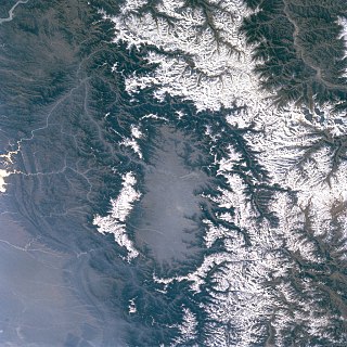
The Kashmir Valley, also known as the Vale of Kashmir, is an intermontane valley in northern Jammu and Kashmir, a region in Indian-administered Kashmir. The valley is surrounded by ranges of the Himalayas, bounded on the southwest by the Pir Panjal Range and on the northeast by the Greater Himalayan range. It is approximately 135 km (84 mi) long and 32 km (20 mi) wide, and drained by the Jhelum River. It forms the bulk of the Kashmir Division of Jammu and Kashmir.
Foothills or piedmont are geographically defined as gradual increases in elevation at the base of a mountain range, higher hill range or an upland area. They are a transition zone between plains and low relief hills and the adjacent topographically higher mountains, hills, and uplands. Frequently foothills consist of alluvial fans, coalesced alluvial fans, and dissected plateaus.
The Karakoram Pass is a 5,540 m or 18,176 ft mountain pass between India and China in the Karakoram Range. It is the highest pass on the ancient caravan route between Leh in Ladakh and Yarkand in the Tarim Basin. 'Karakoram' literally means 'Black Gravel' in Mongolic.

The Ladakh Range is a mountain range in central Ladakh in India with its northern tip extending into Baltistan in Pakistan. It lies between the Indus and Shyok river valleys, stretching to 230 miles (370 km). Leh, the capital city of Ladakh, is on the foot of Ladakh Range in the Indus river valley.
The Mustagh Pass or Muztagh Pass is a mountain pass across the Baltoro Muztagh range in the Karakorams which includes K2, the world's second highest mountain. The crest of the Baltoro Muztagh marks the present border between Pakistani and Chinese territory. Sarpo Laggo Pass is a 6,013-meter (19,728 ft)-high mountain pass at 35.8234°N 76.16249°E near Mustagh Pass.

The snow leopard, commonly known as the ounce, is a species of large cat in the genus Panthera of the family Felidae. The species is native to the mountain ranges of Central and South Asia. It is listed as Vulnerable on the IUCN Red List because the global population is estimated to number fewer than 10,000 mature individuals and is expected to decline about 10% by 2040. It is mainly threatened by poaching and habitat destruction following infrastructural developments. It inhabits alpine and subalpine zones at elevations of 3,000–4,500 m (9,800–14,800 ft), ranging from eastern Afghanistan, the Himalayas and the Tibetan Plateau to southern Siberia, Mongolia and western China. In the northern part of its range, it also lives at lower elevations.

The Indian subcontinent is a physiographical region in Southern Asia, mostly situated on the Indian Plate, projecting southwards into the Indian Ocean from the Himalayas. Geopolitically, it spans major landmasses from the countries of Bangladesh, Bhutan, India, Maldives, Nepal, Pakistan, and Sri Lanka. Although the terms "Indian subcontinent" and "South Asia" are often used interchangeably to denote the region, the geopolitical term of South Asia frequently includes Afghanistan, which is not considered part of the subcontinent.

South Asia is the southern subregion of Asia, which is defined in both geographical and ethnic-cultural terms. As commonly conceptualized, the modern states of South Asia include Afghanistan, Bangladesh, Bhutan, India, Maldives, Nepal, Pakistan, Sri Lanka, and in some cases, Iran. South Asia borders East Asia to the northeast, Central Asia to the northwest, West Asia to the west and Southeast Asia to the east. Topographically, it is dominated by the Indian subcontinent and is bounded by the Indian Ocean in the south, and the Himalayas, Karakoram, and Pamir mountains in the north.
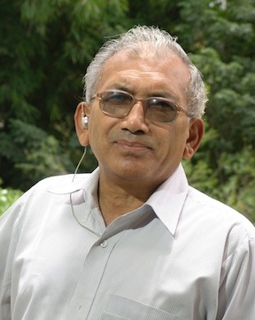
Khadg Singh (KS) Valdiya was an Indian geologist and a former vice chancellor of Kumaon University, known for his contributions in the field of geodynamics. A 2007 recipient of Padma Shri, he was honoured again by the Government of India in 2015 with Padma Bhushan, the third highest Indian civilian award.

Arunachal Pradesh is primarily a hilly tract nestled in the foothills of the Himalayas in northeast India. It is spread over an area of 83,743 km2 (32,333 sq mi). 98% of the geographical area is land out of which 80% is forest cover; 2% is water. River systems in the region, including those from the higher Himalayas and Patkoi and Arakan Ranges, eventually drain into the Brahmaputra River.

Tamotsu Nakamura, FRGS, is a Japanese explorer, alpinist, photographer and author. Since 1990, he has explored the mountainous areas between the Himalayas and the Sichuan basin; which he documents in photographs. He is a leading authority on the Alps of Tibet, the south-eastern sector of the Tibetan high plateau.
References
- ↑ "Mountains in Oman". omantourism.gov.om. Ministry of Tourism, Sultanate of Oman. Retrieved 10 November 2017.
- ↑ "Alborz Mountains". TIME FOR IRAN. Retrieved 11 November 2017.
- ↑ Hatam Chavari, Y; Djamour, Y; Abolghasem, Amir; Bayer, R; Vaníček, P. (2009). "Gravity and height measurements along the profile of Damavand mountain in Iran". ResearchGate.
- ↑ Kenneth Pletcher (2010). The Geography of India: Sacred and Historic Places. The Rosen Publishing Group. p. 28. ISBN 978-16-1530-142-3.
- ↑ "Knuckles Range in Sri Lanka". lanka.com. Retrieved 11 November 2017.
- ↑ "Koriak Mountains". The Great Soviet Encyclopedia (1979), on TheFreeDictionary.com.
- ↑ Jürgen Herget (2005). Reconstruction of Pleistocene Ice-dammed Lake Outburst Floods in the Altai Mountains, Siberia. Geological Society of America. p. 13. ISBN 978-0-8137-2386-0.
- ↑ "Himalayas - Himalayan Ranges: Middle or the Lesser Himalaya". PMF IAS. 17 January 2016.
- ↑ "The Salt Range". WWF Pakistan. Retrieved 12 November 2017.
- ↑ "Himalayas - Himalayan Ranges: Shiwalik Range". PMF IAS. 17 January 2016.
- ↑ Brian Glyn Williams (2011). Afghanistan Declassified: A Guide to America's Longest War. University of Pennsylvania Press. p. 71. ISBN 0-8122-0615-0.
- ↑ John C. Dewdney (2013). A Geography of the Soviet Union: Pergamon Oxford Geographies. Elsevier. p. 10. ISBN 978-1-4831-5799-3.
- ↑ Pakistan: An Official Handbook. Department of Films & Publications, Ministry of Information & Broadcasting, Government of Pakistan. 1991. p. 19.
- 1 2 Ravi Korisettar; Michael D. Petraglia (2003). Early Human Behaviour in Global Context: The Rise and Diversity of the Lower Palaeolithic Record. Routledge. p. 221. ISBN 978-1-134-82856-2.
- ↑ Jamie Woodward (2009). The Physical Geography of the Mediterranean. OUP Oxford. p. 529. ISBN 978-0-19-160841-4.
- ↑ Choudhary RahmatʻAli (1947). Pakistan: The Fatherland of the Pak Nation. Book Traders. p. 40.
- ↑ Defence Journal. Vol. 18. 1992.
- ↑ Malik, Arsalan. "Peaks Of Pakistan" . Retrieved 12 November 2017.