These are the named mountain ranges in Nevada. Some of them are quite small but still constitute distinct biomes.
These are the named mountain ranges in Nevada. Some of them are quite small but still constitute distinct biomes.

The Sierra Nevada is a mountain range in the Western United States, between the Central Valley of California and the Great Basin. The vast majority of the range lies in the state of California, although the Carson Range spur lies primarily in Nevada. The Sierra Nevada is part of the American Cordillera, an almost continuous chain of mountain ranges that forms the western "backbone" of the Americas.

California is a U.S. state on the western coast of North America. Covering an area of 163,696 sq mi (423,970 km2), California is among the most geographically diverse states. The Sierra Nevada, the fertile farmlands of the Central Valley, and the arid Mojave Desert of the south are some of the major geographic features of this U.S. state. It is home to some of the world's most exceptional trees: the tallest, most massive, and oldest. It is also home to both the highest and lowest points in the 48 contiguous states. The state is generally divided into Northern and Southern California, although the boundary between the two is not well defined. San Francisco is decidedly a Northern California city and Los Angeles likewise a Southern California one, but areas in between do not often share their confidence in geographic identity. The US Geological Survey defines the geographic center of the state at a point near North Fork, California.

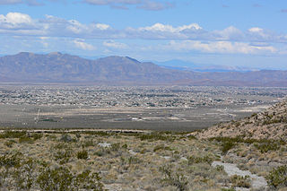
The Black Rock Desert is a semi-arid region of lava beds and playa, or alkali flats, situated in the Black Rock Desert–High Rock Canyon Emigrant Trails National Conservation Area, a silt playa 100 miles (160 km) north of Reno, Nevada that encompasses more than 300,000 acres (120,000 ha) of land and contains more than 120 miles (200 km) of historic trails. It is in the northern Nevada section of the Great Basin with a lakebed that is a dry remnant of Pleistocene Lake Lahontan.

The Walker River is a river in west-central Nevada in the United States, approximately 62 miles (100 km) long. Fed principally by snowmelt from the Sierra Nevada of California, it drains an arid portion of the Great Basin southeast of Reno and flows into the endorheic basin of Walker Lake. The river is an important source of water for irrigation in its course through Nevada; water diversions have reduced its flow such that the level of Walker Lake has fallen 160 feet (49 m) between 1882 and 2010. The river was named for explorer Joseph Reddeford Walker, a mountain man and experienced scout who is known for establishing a segment of the California Trail.

The Tehachapi Mountains are a mountain range in the Transverse Ranges system of California in the Western United States. The range extends for approximately 40 miles (64 km) in southern Kern County and northwestern Los Angeles County and form part of the boundary between the San Joaquin Valley and the Mojave Desert.

The Funeral Mountains are a short, arid mountain range in the United States along the California-Nevada border approximately 100 mi (160 km) west of Las Vegas. The mountains are considered a subrange of the Amargosa Range that form the eastern wall of Death Valley.

The Inyo Mountains are a short mountain range east of the Sierra Nevada in eastern California in the United States. The range separates the Owens Valley to the west from Saline Valley to the east, extending for approximately 70 miles (110 km) south-southeast from the southern end of the White Mountains, from which they are separated by Westgard Pass, to the east of Owens Lake.
The Pah Rah Range is a mountain range located in western Nevada in Washoe County just to the northeast of Reno. It is a hook shaped range with the main eastern portion oriented northwest-southeast, approximately 20 miles (32 km) long. The northwest flowing Cottonwood Creek in Warm Springs Valley is bounded on three sides by the range. To the south and east the Truckee River forms the boundary and Pyramid Lake is at the northeast. Spanish Springs Valley north of Reno forms the southwest margin. To the north the narrow Mullen Pass separates the Pah Rah Range from the Virginia Mountains.
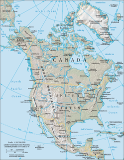
The North American Cordillera, sometimes also called the Western Cordillera of North America, the Western Cordillera or the Pacific Cordillera, is the North American portion of the American Cordillera, the mountain chain system (cordillera) along the western coast of the Americas. The North American Cordillera covers an extensive area of mountain ranges, intermontane basins and plateaus in Western/Northwestern Canada, Western United States and Mexico, including much of the territory west of the Great Plains.

The Virgin Mountains are a mountain range of the northeastern Mojave Desert, located in Clark County, southeastern Nevada and Mohave County, northwestern Arizona.

The New York Mountains are a small mountain range found in northeastern San Bernardino County in California, USA. The range's northeastern area lies in southeastern Nevada. The range lies just south of the small community of Ivanpah, and north of the Lanfair Valley. The mountains are part of the mountain ranges, cones, mountains, and landforms in the Mojave National Preserve. The mountains reach an elevation of 7,533 feet (2,296 m), and run in a mostly southwest-northeasterly direction between the Providence Mountains and the McCullough Range approximately five miles into Nevada and border the northwest corner of the Piute Valley of Nevada-California.

The Diamond Mountains are a mountain range along the border of Eureka and White Pine Counties, in northern Nevada, Western United States.

Oasis is a census-designated place (CDP) located in eastern Elko County, Nevada, United States, at the junction of State Route 233 and Interstate 80, 31 miles (50 km) northwest of the Utah border and 77 miles (124 km) east of Elko. As of the 2008 American Community Survey it had a population of 34.
The Seven Troughs Range is a mountain range in western Pershing County, Nevada.
The Clover Mountains are a mountain range in Lincoln County, Nevada.
The Kern Mountains are a mountain range primarily on the eastern edge of White Pine County, Nevada, United States, but extending slightly east into western Juab County, Utah.
Pahrump Valley is a Mojave Desert valley west of Las Vegas and the Spring Mountains massif in southern Nye County, Nevada, and eastern San Bernardino County, California. Pahrump, Nevada, is in the valley's center and the Tecopa and Chicago Valleys are immediately to the west. The valley has routes to Death Valley and a route to Las Vegas. Pahrump Valley Days is the annual event in February each year, along with the sanctioned JRH-HS Rodeo.

The Mountain States form one of the nine geographic divisions of the United States that are officially recognized by the United States Census Bureau. It is a subregion of the Western United States.
Goodale Mountain is a 12,772-foot-elevation (3,893 meter) mountain summit located one mile east of the crest of the Sierra Nevada mountain range, in Inyo County of northern California. It is situated less than two miles southeast of Taboose Pass in the John Muir Wilderness, on land managed by Inyo National Forest. It is also 16.5 miles (26.6 km) northwest of the community of Independence, and one mile northeast of Striped Mountain, the nearest higher neighbor. Topographic relief is significant as the east aspect rises 7,200 feet (2,200 meters) above Owens Valley in 3.5 miles. It ranks as the 218th highest peak in California.

Sawmill Point is a 9,429-foot-elevation (2,874 meter) mountain summit located in Inyo County, California. It is situated 2.6 miles east of the crest of the Sierra Nevada mountain range, in the John Muir Wilderness, on land managed by Inyo National Forest. It is also 10.5 miles (16.9 km) northwest of the community of Independence, and 2.6 miles (4.2 km) east of proximate parent Colosseum Mountain. Topographic relief is significant as the summit rises 4,770 feet (1,454 meters) above Owens Valley in two miles. The Sawmill Pass Trail traverses the east and south slopes of the peak, providing an approach option, and access to the John Muir Trail.