
Catron County is a county in the U.S. state of New Mexico. As of the 2010 census, the population was 3,725, making it New Mexico's third-least populous county. Its county seat is Reserve. Catron County is New Mexico's largest county by area.

Victorio was a warrior and chief of the Warm Springs band of the Tchihendeh division of the central Apaches in what is now the American states of Texas, New Mexico, Arizona, and the Mexican states of Sonora and Chihuahua.

Mescalero or Mescalero Apache is an Apache tribe of Southern Athabaskan–speaking Native Americans. The tribe is federally recognized as the Mescalero Apache Tribe of the Mescalero Apache Reservation, located in south-central New Mexico.

The Cibola National Forest is a 1,633,783 acre United States National Forest in New Mexico, USA. The name Cibola is thought to be the original Zuni Indian name for their pueblos or tribal lands. The name was later interpreted by the Spanish to mean "buffalo." The forest is disjointed with lands spread across central and northern New Mexico, west Texas and Oklahoma. The Cibola National Forest is divided into four Ranger Districts: the Sandia, Mountainair, Mt. Taylor, and Magdalena. The Forest includes the San Mateo, Magdalena, Datil, Bear, Gallina, Manzano, Sandia, Mt. Taylor, and Zuni Mountains of west-central New Mexico. The Forest also manages four National Grasslands that stretch from northeastern New Mexico eastward into the Texas Panhandle and western Oklahoma. The Cibola National Forest and Grassland is administered by Region 3 of the United States Forest Service from offices in Albuquerque, New Mexico. Elevation ranges from 5,000 ft to 11,301 ft. The descending order of Cibola National Forest acres by county are: Socorro, Cibola, McKinley, Catron, Torrance, Bernalillo, Sandoval County, New Mexico, Lincoln, Sierra, and Valencia counties in New Mexico. The Cibola National Forest currently has 137,701 acres designated as Wilderness. In addition to these acres, it has 246,000 acres classified as Inventoried Roadless Areas pursuant to the Roadless Area Conservation Rule.

The Sacramento Mountains are a mountain range in the south-central part of the U.S. state of New Mexico, lying just east of Alamogordo in Otero County. From north to south, the Sacramento Mountains extend for 85 miles (137 km), and from east to west they encompass 42 miles (68 km).
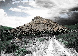
Victorio Peak is a high rocky outcropping in the Hembrillo Basin in southern New Mexico. This was one of Chief Victorio's hideouts, and was the site of a battle in 1880 between Victorio's Apaches and the U.S. Army Ninth Cavalry "Buffalo Soldiers." Additionally, gold prospector Milton "Doc" Noss claimed to have found hidden treasure inside the Mountains in the late 1930s.

The Sierra Blanca is an ultra-prominent range of volcanic mountains in Lincoln and Otero counties in the south-central part of the U.S. state of New Mexico. The range is about 40 miles (64 km) from north to south and 20 miles (32 km) wide.

The Plains of San Agustin is a region in the southwestern U.S. state of New Mexico in the San Agustin Basin, south of U.S. Highway 60. The area spans Catron and Socorro Counties, about 50 miles (80 km) west of the town of Socorro and about 25 miles north of Reserve. The plains extend roughly northeast-southwest, with a length of about 55 miles (88 km) and a width varying between 5–15 miles (8–24 km). The basin is bounded on the south by the Luera Mountains and Pelona Mountain ; on the west by the Tularosa Mountains; on the north by the Mangas, Crosby, Datil, and Gallinas Mountains; and on the east by the San Mateo Mountains. The Continental Divide lies close to much of the southern and western boundaries of the plains.
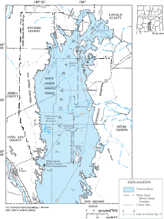
The Tularosa Basin is a graben basin in the Basin and Range Province and within the Chihuahuan Desert, east of the Rio Grande in southern New Mexico and West Texas, in the Southwestern United States.

The San Mateo Mountains are a mountain range in Socorro County, in west-central New Mexico in the southwestern United States. The highest point in the range is West Blue Mountain, at 10,336 ft. The range runs roughly north-south and is about 40 miles (64 km) long. It lies about 25 miles (40 km) north-northwest of the town of Truth or Consequences and about 30 miles (48 km) southwest of Socorro. They should not be confused with the identically named range in Cibola and McKinley counties, north of this range.

Salinas Peak is the highest point in the San Andres Mountains of south-central New Mexico, in the United States. It lies near the northern end of the range, about 50 miles (80 km) northwest of Alamogordo and 50 miles (80 km) southeast of Socorro. To the east lies the Tularosa Basin, while to the west is the Jornada del Muerto.
Apache Kid Wilderness is a 44,626-acre (18,060 ha) Wilderness area located within the Magdalena Ranger District of the Cibola National Forest in the state of New Mexico. Straddling a southern portion of the San Mateo Mountains of southwestern Socorro County, the area is characterized by rugged, narrow, and steep canyons bisecting high mountain peaks exceeding 10,000 feet (3,000 m). The highest peak is West Blue Mountain which reaches an elevation of 3,151 metres (10,338 ft).

The San Augustin Mountains are a small mountain subrange located at the southern terminus of the San Andres Mountains east of Las Cruces, New Mexico.
Victorio's War, or the Victorio Campaign, was an armed conflict between the Apache followers of Chief Victorio, the United States, and Mexico beginning in September 1879. Faced with arrest and forcible relocation from his homeland in New Mexico to San Carlos Indian Reservation in southeastern Arizona, Victorio led a guerrilla war across southern New Mexico, west Texas and northern Mexico. Victorio fought many battles and skirmishes with the United States Army and raided several settlements until the Mexican Army killed him and most of his warriors in October 1880 in the Battle of Tres Castillos. After Victorio's death, his lieutenant Nana led a raid in 1881.
The San Andres Formation is a geologic formation found in New Mexico and Texas. It contains fossils characteristic of the late Leonardian (Kungurian) Age) of the Permian Period.
The Gray Mesa Formation is a geologic formation in New Mexico. Its fossil assemblage dates the formation to the Moscovian age of the Pennsylvanian.

Oscura Mountains, originally known to the Spanish as the Sierra Oscura, are a ridge of mountains, trending north and south, east of the Jornada del Muerto and west of the Tularosa Valley. It is located in Socorro County and Lincoln County, New Mexico. Their highest elevation is Oscura Peak at 8,625 feet / 2,629 meters. Its southern end is at 33°30′30″N106°18′45″W and its north end is at 33°49′15″N106°22′20″W near North Oscura Peak.