
The Great Basin Desert is part of the Great Basin between the Sierra Nevada and the Wasatch Range. The desert is a geographical region that largely overlaps the Great Basin shrub steppe defined by the World Wildlife Fund, and the Central Basin and Range ecoregion defined by the U.S. Environmental Protection Agency and United States Geological Survey. It is a temperate desert with hot, dry summers and snowy winters. The desert spans large portions of Nevada and Utah, and extends into eastern California. The desert is one of the four biologically defined deserts in North America, in addition to the Mojave, Sonoran, and Chihuahuan Deserts.

The San Francisco Peaks are a volcanic mountain range in the San Francisco volcanic field in north central Arizona, just north of Flagstaff and a remnant of the former San Francisco Mountain. The highest summit in the range, Humphreys Peak, is the highest point in the state of Arizona at 12,633 feet (3,851 m) in elevation. The San Francisco Peaks are the remains of an eroded stratovolcano. An aquifer within the caldera supplies much of Flagstaff's water while the mountain itself is in the Coconino National Forest, a popular recreation site. The Arizona Snowbowl ski area is on the western slopes of Humphreys Peak, and has been the subject of major controversy involving several tribes and environmental groups.

The Davis Mountains, originally known as Limpia Mountains, are a range of mountains in West Texas, located near Fort Davis, after which they are named. The fort was named for then United States Secretary of War and later Confederate President Jefferson Davis. They are a popular site for camping and hiking and the region includes Fort Davis National Historic Site and Davis Mountains State Park. The historical and architectural value of the fort, alongside the rugged natural environment of the park are a significant destination for tourism in Texas.
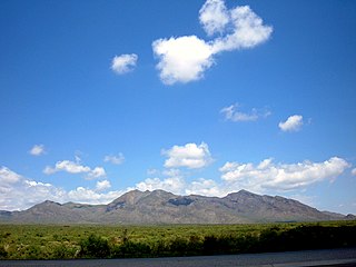
The San Andres Mountains are a mountain range in the southwestern U.S. state of New Mexico, in the counties of Socorro, Sierra, and Doña Ana. The range extends about 75 miles (121 km) north to south, but are only about 12 miles (19 km) wide at their widest. The highest peak in the San Andres Mountains is Salinas Peak, at 8,965 feet (2,733 m).

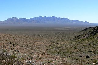
The Mormon Mountains are located in Lincoln and Clark counties in Nevada, between 16 and 28 miles (45 km) northwest of Mesquite on I–15 in the Virgin Valley, east of the Meadow Valley Mountains and Meadow Valley and northeast of Moapa Valley. The highest point in the range is Mormon Peak, at 7,414 feet (2,260 m) above sea level. Another smaller mountain range lies to the east, called the East Mormon Mountains. The south fork of the Toquop Wash drains the east side of the range and continues on through the N–S linear ridge of the East Mormon Mountains.
The Kingston Range, sometimes called the Kingston Mountains, is located in Inyo and San Bernardino counties in the Mojave Desert in eastern California. The range reaches a height of 7,323 feet (2,232 m) above sea level at Kingston Peak.
The Pine Nut Mountains are a north–south mountain range in the Great Basin, in Douglas and Lyon counties of northwestern Nevada, United States. The highest mountain in the range is Mount Siegel at 9,456 ft.

The Tularosa Basin is a graben basin in the Basin and Range Province and within the Chihuahuan Desert, east of the Rio Grande in southern New Mexico and West Texas, in the Southwestern United States.

Salinas Peak is the highest point in the San Andres Mountains of south-central New Mexico, in the United States. It lies near the northern end of the range, about 50 miles (80 km) northwest of Alamogordo and 50 miles (80 km) southeast of Socorro. To the east lies the Tularosa Basin, while to the west is the Jornada del Muerto.

The Carrizozo volcanic field is a monogenetic volcanic field located in New Mexico, US. The volcanic field consists of two lava flows, the Broken Back flow and the Carrizozo lava flow, the second youngest in New Mexico. Both lava flows originated from groups of cinder cones. The Broken Back flow is approximately 16 kilometres (10 mi) long and the Carrizozo, one of the largest in the world, is 68 kilometres (42 mi) long, covering 328 square kilometres (127 sq mi) with a volume of 4.2 cubic kilometres (1.0 cu mi).
North Oscura Peak, is a summit in the Oscura Mountains in Socorro County, New Mexico is the location of an Air Force Research Laboratory (AFRL) site in the northern portion of the White Sands Missile Range. It rises to an elevation of 7,976 feet.

The Kiavah Wilderness is a federally designated wilderness area located in the Mojave Desert, Scodie Mountains, and southern Sierra Nevada in Kern County, California, United States. California State Route 178 connects the town of Lake Isabella to State Highway 14 in the east, crossing Walker Pass at the north boundary of the wilderness.

The Northern Basin and Range ecoregion is a Level III ecoregion designated by the United States Environmental Protection Agency (EPA) in the U.S. states of Oregon, Idaho, Nevada, Utah, and California. It contains dissected lava plains, rolling hills, alluvial fans, valleys, and scattered mountain ranges in the northern part of the Great Basin. Although arid, the ecoregion is higher and cooler than the Snake River Plain to the north and has more available moisture and a cooler climate than the Central Basin and Range to the south. Its southern boundary is determined by the highest shoreline of Pleistocene Lake Bonneville, which once inundated the Central Basin and Range. The western part of the region is internally drained; its eastern stream network drains to the Snake River system.
The San Andres National Wildlife Refuge is located in the southern San Andres Mountains of southcentral New Mexico, USA. The refuge, which lies within the northernmost extension of the Chihuahuan Desert, has elevations ranging from 4,200 feet (1,300 m) to 8,239 feet (2,511 m) feet. Refuge habitats vary from creosote and Chihuahuan desert grasslands in the bajadas to pinyon-juniper woodlands at higher elevations. A few springs, seeps, and seasonal streams provide water for wildlife and riparian habitats in the refuge.
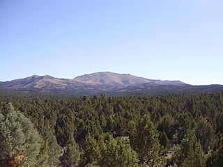
Pinyon–juniper woodland, also spelled piñon–juniper woodland, is a vegetation type (biome) of Western United States higher elevation deserts, characterized by being an open forest dominated by low, bushy, evergreen junipers, pinyon pines, and their associates which vary from region to region. The woodland's density and crown height varies dramatically depending on the site's soil and climate, the age of the stand, and the particular species present, with mature trees ranging in height from as low as 2 meters up to 15 meters. At lower elevations, junipers often predominate and trees are spaced widely, bordering on and mingling with grassland or shrubland. As elevation increases, pinyon pines become common and trees grow closer, forming denser canopies. Historically, pinyon-juniper woodland has provided a vital source of fuel and food for peoples of the American Southwest.

The San Augustin Mountains are a small mountain subrange located at the southern terminus of the San Andres Mountains east of Las Cruces, New Mexico.

The Great Basin montane forests is an ecoregion of the Temperate coniferous forests biome, as designated by the World Wildlife Fund (WWF).

The pinyon jay is a species of jay, and is the only member of the genus Gymnorhinus. Native to Western North America, the species ranges from central Oregon to northern Baja California, and eastward as far as western Oklahoma, though wanderers are often sighted beyond this range. It is typically found within foothills, especially where pinyon pines occur.
Sagebrush scrub is a vegetation type (biome) of mid to high elevation Western United States deserts characterized by low growing, drought resistant shrubs including sagebrush and its associates. It is the dominant vegetation type of the Great Basin Desert, occurs along the margins of the Mojave Desert, including in the southern slopes of the Sierra Nevadas and Transverse Ranges of California, and occurs in the Colorado Plateau and Canyonlands region, where it may be referred to as cool desert shrub.
Oscura Peak is a mountain summit in the Oscura Mountains in Socorro County, New Mexico. Its elevation is 8,625 feet.

