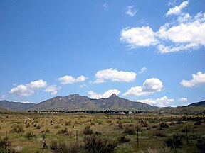
The Organ Mountains are a rugged mountain range in southern New Mexico in the Southwestern United States. Organ Mountains–Desert Peaks National Monument was declared a national monument on May 21, 2014. They lie 10 mi (16 km) east of the city of Las Cruces, in Doña Ana County.

The Peloncillo Mountains of Cochise County is a mountain range in northeast Cochise County, Arizona. A northern north–south stretch of the range extends to the southern region of Greenlee County on the northeast, and a southeast region of Graham County on the northwest. The north stretch of the Peloncillo's forms the border between the two counties. It lies east and northeast of the Willcox Playa, and the San Simon Valley.
The San Luis Mountains are a small, lower elevation mountain range of central-southern Pima County Arizona adjacent to the U.S.-Mexico border, northeast of Sasabe, Arizona–Sasabe, Sonora.

The Galiuro Mountains are a large sky island mountain range of southeast Arizona, United States. It is a northerly mountain range in the Madrean Sky Islands region of southeast Arizona, northern Sonora in northwestern Mexico, and the extreme southwest of New Mexico.
The Little Burro Mountains are a short 15 mi (24 km) long mountain range located in Grant County, New Mexico. The range lies adjacent to the southeast border of the larger Big Burro Mountains. The Little Burro Mountains are located 8 mi southwest of Silver City. State Road 90 from Silver City skirts the southern perimeter of the range on its route to Lordsburg.
The Canyon Creek Mountains are a short 10 miles (16 km) long, mountain range located in southeast Catron County, New Mexico near the source of the Gila River and north of the Gila Wilderness. The Elk Mountains are adjacent northwest, where the continental divide passes from north to east on the south of the Plains of San Agustin.
The Cedar Mountain Range is a short 20 mi (32 km) long, mountain range in southwest Luna County, New Mexico, USA, just north of the Mexico–United States border with Chihuahua.
The Luera Mountains are a 15 mi (24 km) long, mountain range in southeast Catron County, New Mexico, USA in the central-southeast of the Plains of San Agustin. The range abuts the northwest end of the north-south extensive Black Range where the Continental Divide of the Americas traverses the Black Range's ridgeline.

The Big Burro Mountains are a moderate length 35-mile (56 km) long, mountain range located in central Grant County, New Mexico. The range's northwest-southeast 'ridgeline' is located 15 mi southwest of Silver City.
The Fra Cristobal Range, is a 17 mi (27 km) long, mountain range in central-north Sierra County, New Mexico. Its northern extreme above Fra Cristoblal Mountain extends into Socorro County. The range borders the eastern shore of Elephant Butte Reservoir on the Rio Grande, and the range lies towards the southwest of the Jornada del Muerto, the desert region east of the river.

The Poachie Range is a moderate length mountain range and massif in southeast Mohave County, Arizona, and the extreme southwest corner of Yavapai County; the range also abuts the northeast corner of La Paz County. The Poachie Range massif is bordered by the south-flowing Big Sandy River on its west, and the west-flowing Santa Maria River on its south; both rivers converge at the Poachie Range's southwest at Alamo Lake in Alamo Lake State Park.
The Guadalupe Mountains of Hidalgo County are a 13 mi (21 km) long, sub–range in southwest Hidalgo County, New Mexico, adjacent the southeast border of Arizona's Cochise County. A small portion of the range is in Cochise County, namely the outlet of Guadalupe Canyon, famous for the Guadalupe Canyon Massacre. The very southern end of the range is also in the border region of Sonora, just north of Federal Highway 2.
The West Hills are a 20-mile long (32 km) mountain range located in northeast Box Elder County, Utah, United States. The range is connected to the Samaria Mountains, a small range on the north in southern Idaho. The West Hills are also connected to another section on the southwest, the Blue Spring Hills. West of the Blue Spring and West Hills is a long north–south valley, the Blue Creek Valley.

The San Francisco Mountains are a 20-mile-long (32 km) mountain range located in north‑central Beaver County, Utah, United States that extend into central-south Millard County.
The Hogup Mountains are a small 25-mile (40 km) long mountain range located in central Box Elder County, Utah, United States. The range lies on the northwest perimeter of the Great Salt Lake, and also lies surrounded by the Great Salt Lake Desert; it lies in the desert's northeast.
The Fish Springs Range is a 16-mile (26 km) long narrow, and north-trending mountain range located in center-west Juab County, Utah. The northeast of the range borders the Fish Springs National Wildlife Refuge; the entire east of the range borders the Fish Springs Flat, where the east region of the flat borders the Thomas Range.

The Gilson Mountains are an 11-mile (18 km) long almost circular, small mountain range adjacent the north terminus of the Canyon Mountains,, located in far eastern Juab County, Utah, United States.
The Black Mountains is a 30-mile (48 km) long mountain range in northeastern Iron County and southeastern Beaver County in southwestern Utah, United States.
The Valley Mountains are a 28-mile (45 km) long mountain range located on the southwest border of Sanpete County, Utah, with the northeast border of Millard County. The north of the range is in Juab County; the south in Sevier County.
The Peacock Mountains are a small, 26 mi (42 km) long mountain range in northwest Arizona, US. The range is a narrow sub-range, and an extension north, at the northeast of the Hualapai Mountains massif, which lies to the southwest. The range is defined by the Hualapai Valley to the northwest, and north and south-flowing washes on its east border, associated with faults and cliffs; the Cottonwood Cliffs are due east, and are connected to the Aquarius Cliffs southward at the west perimeter of the Aquarius Mountains; the cliffs are a result of the Aquarius Fault, which is an extension southward from the Grand Wash Cliffs and Grand Wash Fault which crosses the Colorado River at Lake Mead, and the west perimeter of the Grand Canyon/Colorado Plateau.