San Antonio Mountain (New Mexico)

Last updated

San Antonio Mountain
San Antonio Mountain.jpg
San Antonio Mountain, New Mexico, as seen from the Colorado side of the NM-CO state line on U.S. Route 285
Highest point
Elevation 10,912 ft (3,326 m)  NAVD 88 [1]
Prominence 2,108 ft (643 m) [2]
Coordinates 36°51′34″N106°01′07″W / 36.859444953°N 106.018705147°W / 36.859444953; -106.018705147
Geography
USA New Mexico relief location map.svg
Red triangle with thick white border.svg
San Antonio Mountain
Location Rio Arriba County, New Mexico, U.S.
Topo map USGS San Antonio Mountain N. Mex.
Geology
Mountain type Shield volcano
Volcanic arc Taos Plateau volcanic field

San Antonio Mountain is a free-standing volcanic peak in Rio Arriba County, New Mexico. With an elevation of 10,908 feet, San Antonio Mountain is the highest peak within the Taos Plateau volcanic field, the largest volcanic field within the Rio Grande Rift valley.

Contents

The mountain lies just outside a northwest boundary of the Rio Grande del Norte National Monument. It lies within the Carson National Forest and is administered by the U.S. Forest Service rather than the Bureau of Land Management.

It is called "Bear Mountain" by Tewa-speaking peoples in the Rio Grande valley, and is known as the mountain of the north in their cosmology. [3]

Geography

San Antonio Mountain is one of several volcanic peaks within the 7000 square kilometer Taos Plateau volcanic field, a region of volcanic activity within the Rio Grande rift valley. Other nearby peaks include Ute Mountain (10,082 feet), Cerro de la Olla (9,475 feet), Cerro del Aire (9,023 feet), and Cerro Montoso (8,655 feet). San Antonio Mountain is both the highest peak in the region and possesses the greatest relief, but it is shorter than the highest peaks in the surrounding ranges: Grouse Mesa (11,403 feet) in the Tusas Mountains to the west, and Wheeler Peak (13,161 feet) in the Sangre de Cristo Mountains to the east. However, because it stands alone, San Antonio Mountain is a distinctive feature that can be seen from as far as 60 or more miles away in southern Colorado and northern New Mexico. [3]

San Antonio Mountain has a base diameter of five miles, and rises dramatically from the surrounding sagebrush plains of the lower San Luis Valley. [3]

Forest Road 418 goes to the top, where there are radio and television towers. However it may not be open to motorized travel by the general public, as there is a locked gate where the road crosses private property. Hikers may walk around the private property. [4]

Climate

Climate data for San Antonio Mountain 36.8596 N, 106.0263 W, Elevation: 10,794 ft (3,290 m) (1991–2020 normals)
MonthJanFebMarAprMayJunJulAugSepOctNovDecYear
Mean daily maximum °F (°C)31.1
(−0.5)
32.0
(0.0)
38.6
(3.7)
44.2
(6.8)
53.3
(11.8)
65.0
(18.3)
68.8
(20.4)
66.3
(19.1)
60.3
(15.7)
50.0
(10.0)
38.2
(3.4)
31.0
(−0.6)
48.2
(9.0)
Daily mean °F (°C)20.6
(−6.3)
21.2
(−6.0)
26.9
(−2.8)
32.3
(0.2)
41.3
(5.2)
51.9
(11.1)
56.2
(13.4)
54.4
(12.4)
48.5
(9.2)
38.7
(3.7)
28.0
(−2.2)
20.9
(−6.2)
36.7
(2.6)
Mean daily minimum °F (°C)10.1
(−12.2)
10.4
(−12.0)
15.1
(−9.4)
20.4
(−6.4)
29.3
(−1.5)
38.9
(3.8)
43.6
(6.4)
42.5
(5.8)
36.7
(2.6)
27.3
(−2.6)
17.9
(−7.8)
10.8
(−11.8)
25.3
(−3.8)
Average precipitation inches (mm)3.15
(80)
3.28
(83)
3.47
(88)
2.42
(61)
1.56
(40)
0.97
(25)
2.20
(56)
2.63
(67)
1.91
(49)
2.03
(52)
2.54
(65)
3.20
(81)
29.36
(747)
Source: PRISM Climate Group [5]

Geology

The mountain is a dacite dome, built up of lava high in silica and mildly elevated in alkali metal oxides that erupted between 3.36 and 2.9 million years ago. Most of the mountain consists of dacite flows up to 30 meters (100 ft) thick. These are glassy at their bases, massive and grey in their center sections, and blocky on the upper surfaces. These are sometimes oxidized to a red color. The mountain has north and south summits separated by a shallow saddle, with cinder and spatter around the southern summit that shows this was the youngest vent area. The mountain almost buries a slightly older and much smaller andesite cone to the northwest. [6]

Flora and fauna

The mountain features Gambel oak and ponderosa pine, with Douglas fir, Engelmann spruce, and quaking aspens at higher elevations. [3] [7]

San Antonio Mountain is an important winter habitat for migrating herds of elk, and hosts one of the largest populations of elk in New Mexico, estimated at 7,000 individuals. [8] The mountain and its surroundings also provide habitat for pronghorn, golden eagle, hawks, bears, mountain lions, mule deer and white-tailed jackrabbits among other smaller mammals. In the fall, the Stuart Meadows wetlands on the nearby Rio San Antonio provide a stopover for migrating Sandhill cranes, mallards, American wigeon, Northern pintail, common yellowthroat, and sora. [7]

Related Research Articles

<span class="mw-page-title-main">Wheeler Peak (New Mexico)</span> Mountain in New Mexico, United States

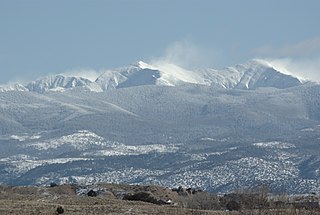
Wheeler Peak is the highest natural point in the U.S. state of New Mexico. It is located northeast of Taos and south of Red River in the northern part of the state, and just 2 miles (3.2 km) southeast of the ski slopes of Taos Ski Valley. It lies in the Sangre de Cristo Mountains, the southernmost subrange of the Rocky Mountains. The peak's elevation is 13,167 feet (4,013 m).

<span class="mw-page-title-main">Sierra Madre Oriental</span> Mountain range in Mexico

The Sierra Madre Oriental is a mountain range in northeastern Mexico. The Sierra Madre Oriental is part of the American Cordillera, a chain of mountain ranges (cordillera) that consists of an almost continuous sequence of mountain ranges that form the western "backbone" of North America, Central America, South America, and Antarctica.

<span class="mw-page-title-main">Santa Fe Baldy</span>

Santa Fe Baldy is a prominent summit in the Sangre de Cristo Mountains of New Mexico, United States, located 15 mi (24 km) northeast of Santa Fe. There are no higher mountains in New Mexico south of Santa Fe Baldy. It is prominent as seen from Los Alamos and communities along the Rio Grande in northern New Mexico, but is relatively inconspicuous from Santa Fe, as its north-south trending main ridge line is seen nearly end-on, disguising the size of the mountain. Tree line in the Sangre de Cristos is unusually high and only the top 600 to 800 feet of the mountain is perpetually free of trees, but several severe forest fires have created bare spots extending to lower elevations. An extensive region of aspen trees on its flanks produces spectacular orange-yellow coloration during the fall that is the subject of many photographic studies.

<span class="mw-page-title-main">Mount Taylor (New Mexico)</span> Stratovolcano in the San Mateo Mountains, North America

Mount Taylor is a dormant stratovolcano in northwest New Mexico, northeast of the town of Grants. It is the high point of the San Mateo Mountains and the highest point in the Cibola National Forest.

<span class="mw-page-title-main">Sierra Blanca (New Mexico)</span> Mountain range in New Mexico, USA

The Sierra Blanca is an ultra-prominent range of volcanic mountains in Lincoln and Otero counties in the south-central part of the U.S. state of New Mexico. The range is about 40 miles (64 km) from north to south and 20 miles (32 km) wide.

<span class="mw-page-title-main">Carson National Forest</span> National forest in New Mexico, United States

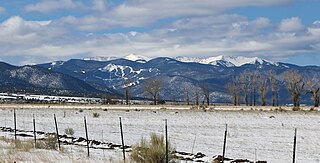
Carson National Forest is a national forest in northern New Mexico, United States. It encompasses 6,070 square kilometers and is administered by the United States Forest Service. The Forest Service's "mixed use" policy allows for its use for recreation, grazing, and resource extraction.

<span class="mw-page-title-main">Sandia Crest</span> Highpoint of the Sandia-Manzano Mountains in New Mexico, United States

Sandia Crest, also known locally as Sandia Peak or simply as the Crest, is a mountain ridge that, at 10,679 feet (3,255 m), is the highpoint of the Sandia–Manzano Mountains, and is located in the Sandia Mountains of Bernalillo County, New Mexico, United States. Instead of a true summit or topographic peak, this range climbs to a long ridge line. To the east, the range slopes down from the Crest and merges into the plains below. On the west side of the Crest is a cliff; the range dramatically drops over 4,000 feet in elevation over 2 miles of horizontal distance to the Rio Grande Valley and city of Albuquerque below. It is within the Sandia Ranger District of the Cibola National Forest. The Crest features a viewing area with a shop and visitor center, telecommunications transmitters, the popular La Luz Trail, the Sandia Mountain Wilderness, and the summit of Sandia Peak Ski Area and the Sandia Peak Tramway, which is the longest aerial tramway in the Americas.

<span class="mw-page-title-main">Truchas Peak</span>

Truchas Peak is the second highest peak in the U.S. State of New Mexico behind Wheeler Peak. It is in the Sangre de Cristo Mountains 26 miles (42 km) northeast of Santa Fe. It lies within the Pecos Wilderness, part of the Santa Fe National Forest. The name of the peak is Spanish for "trout" (plural). It is the highest point in both Rio Arriba and Mora counties. It is also the most southerly peak and land area in the continental United States to rise above 13,000 feet (3,962 m).

<span class="mw-page-title-main">Venado Peak</span>

Venado Peak is one of the major peaks of the Taos Mountains group of the Sangre de Cristo Mountains, a subrange of the Rocky Mountains. It is located in Taos County, New Mexico, about 8 miles (13 km) northeast of the town of Questa. Its summit is the highest point in the Latir Peak Wilderness, part of Carson National Forest. The peak's name means "deer" in Spanish.

<span class="mw-page-title-main">Mount Baldy (Arizona)</span> Mountain in Apache County, Arizona, United States

Mount Baldy is an extinct stratovolcano in eastern Arizona in the United States. With a summit elevation of 11,409 feet (3,477 m), the peak of Mount Baldy rises above the tree line and is left largely bare of vegetation, lending the mountain its current name. The Mount Baldy Wilderness occupies the eastern slope of the mountain and is managed by the Apache-Sitgreaves National Forest.

Caja del Rio is a dissected plateau, of volcanic origin, which covers approximately 84,000 acres of land in northern Santa Fe County, New Mexico, United States. The region is also known as the Caja, Caja del Rio Plateau, and Cerros del Rio. The center of the area is approximately 15 miles (23 km) west of Santa Fe, New Mexico. Most of the Caja is owned by the United States Forest Service and managed by the Santa Fe National Forest. Access is through New Mexico Highway 599, Santa Fe County Road 62, and Forest Service Road 24.

<span class="mw-page-title-main">Beaverhead Mountains</span> Mountain range in the U.S. states of Montana and Idaho

The Beaverhead Mountains, highest point Scott Peak, el. 11,393 feet (3,473 m), are a mountain range straddling the Continental Divide in the U.S. states of Montana and Idaho. They are a sub-range of the Bitterroot Range, and divide Beaverhead County, Montana from Lemhi County, Idaho and Clark County, Idaho.

<span class="mw-page-title-main">Rio Grande del Norte National Monument</span> Protected area in New Mexico, United States

The Rio Grande del Norte National Monument is an approximately 242,555-acre (98,159 ha) area of public lands in Taos County, New Mexico, United States, proclaimed as a national monument on March 25, 2013, by President Barack Obama under the provisions of the Antiquities Act. It consists of the Rio Grande Gorge and surrounding lands, managed by the Bureau of Land Management (BLM).

South River Peak, elevation 13,154 ft (4,009 m), is a summit in the San Juan Mountains of southwestern Colorado, United States. The mountain is in the Weminuche Wilderness of Rio Grande National Forest.

<span class="mw-page-title-main">Bennett Peak</span> Mountain in Colorado, United States

Bennett Peak is a high and prominent mountain summit in the San Juan Mountains range of the Rocky Mountains System, in southwestern Colorado.

<span class="mw-page-title-main">Wild Rivers Recreation Area</span>

Wild Rivers Recreation Area is located in north central New Mexico within the Rio Grande del Norte National Monument. Two rivers that run through the park, the Rio Grande and Red River are National Wild and Scenic Rivers. NM 378 that traverses the recreation area is designated a New Mexico Scenic Byway. Recreational opportunities include whitewater rafting, hiking, biking, fishing and camping.

<span class="mw-page-title-main">Rio San Antonio (Colorado–New Mexico)</span> River in New Mexico, United States

Rio San Antonio is a tributary of the Conejos River in northern New Mexico and southern Colorado. Via the Conejos River, it is part of the upper Rio Grande system. The river is used extensively for irrigation in its lower course through the southern San Luis Valley.

<span class="mw-page-title-main">Tusas Mountains</span> Mountain range in New Mexico, United States

The Tusas Mountains are a mountain range in northern New Mexico, extending slightly into southern Colorado. They are considered the southeasternmost part of the San Juan Mountains. Grouse Mesa, 11,407 feet (3,477 m), is the highest peak in the range. The mountains are located to the west of Taos and northwest of Santa Fe. The Tusas Mountains are a wide region of upland mesas and gently sloping mountains, dissected in places by deep canyons.

Cerro del Yuta Wilderness is a 13,420-acre wilderness area in the Rio Grande del Norte National Monument managed by the U.S. Bureau of Land Management in the U.S. state of New Mexico. Established in 2019, this Wilderness is centered around Ute Mountain, the high point of the monument at 10,093 feet. The mountain is a volcanic cone set atop the Taos Plateau. The area's forest is made up of pinyon pine and juniper on the lower slopes, with ponderosa pine and douglas fir on the upper north facing slopes, and even some aspen groves close to the summit.

<span class="mw-page-title-main">Ute Mountain (New Mexico)</span>

Ute Mountain is a 10,093-foot elevation (3,076 m) summit located in Taos County, New Mexico, United States.

References

  1. "San Antone". NGS Data Sheet. National Geodetic Survey, National Oceanic and Atmospheric Administration, United States Department of Commerce . Retrieved February 14, 2014.
  2. "San Antonio Mountain, New Mexico". Peakbagger.com. Retrieved February 14, 2014.
  3. 1 2 3 4 Julyan, Robert Hixson (2006). The Mountains of New Mexico. UNM Press. p. 368. ISBN   0826335160.
  4. "San Antonio Mountain Forest Road 418". summitpost.org. Retrieved October 30, 2021.
  5. "PRISM Climate Group, Oregon State University". PRISM Climate Group, Oregon State University. Retrieved October 2, 2023. To find the table data on the PRISM website, start by clicking Coordinates (under Location); copy Latitude and Longitude figures from top of table; click Zoom to location; click Precipitation, Minimum temp, Mean temp, Maximum temp; click 30-year normals, 1991-2020; click 800m; click Retrieve Time Series button.
  6. Turner, Kenzie J.; Thompson, Ren A.; Cosca, Michael A.; Shroba, Ralph R.; Chan, Christine F.; Morgan, Leah E. (2018). "Geologic map of the San Antonio Mountain area, northern New Mexico and southern Colorado". USGS Scientific Investigations Map. Scientific Investigations Map. 3417. doi: 10.3133/sim3417 .
  7. 1 2 "San Antonio Mountain - Watchable Wildlife Site #14" (PDF). Wildlife Restoration. Archived from the original (PDF) on October 29, 2013. Retrieved October 26, 2013.
  8. Smallidge, Samuel T.; et al. (March 2003). "Demographics, temporal and spatial dynamics, and resource conflict evaluation of elk wintering near San Antonio Mountain in North Central New Mexico" (PDF). Federal Aid in Wildlife Restoration Project W-136-R. New Mexico Game & Fish and Wildlife Restoration. Archived from the original (PDF) on July 23, 2013. Retrieved October 26, 2013.