Shield volcano

Last updated
Mauna Loa, a shield volcano in Hawaii Mauna Loa Volcano.jpg
Mauna Loa, a shield volcano in Hawaii
An Ancient Greek warrior's shield--its circular shape and gently sloping surface, with a central raised area, is a shape shared by many shield volcanoes. Bronze votive shield.JPG
An Ancient Greek warrior's shield—its circular shape and gently sloping surface, with a central raised area, is a shape shared by many shield volcanoes.

A shield volcano is a type of volcano named for its low profile, resembling a shield lying on the ground. It is formed by the eruption of highly fluid (low viscosity) lava, which travels farther and forms thinner flows than the more viscous lava erupted from a stratovolcano. Repeated eruptions result in the steady accumulation of broad sheets of lava, building up the shield volcano's distinctive form.

Contents

Shield volcanoes are found wherever fluid, low-silica lava reaches the surface of a rocky planet. However, they are most characteristic of ocean island volcanism associated with hot spots or with continental rift volcanism. [1] They include the largest active volcanoes on Earth, such as Mauna Loa. Giant shield volcanoes are found on other planets of the Solar System, including Olympus Mons on Mars [2] and Sapas Mons on Venus. [3]

Etymology

The term 'shield volcano' is taken from the German term Schildvulkan, coined by the Austrian geologist Eduard Suess in 1888 and which had been calqued into English by 1910. [4] [5]

Geology

Structure

Diagram of the common structural features of a shield volcano

Shield volcanoes are distinguished from the three other major volcanic types stratovolcanoes, lava domes, and cinder cones by their structural form, a consequence of their particular magmatic composition. Of these four forms, shield volcanoes erupt the least viscous lavas. Whereas stratovolcanoes and lava domes are the product of highly viscous flows, and cinder cones are constructed of explosively eruptive tephra, shield volcanoes are the product of gentle effusive eruptions of highly fluid lavas that produce, over time, a broad, gently sloped eponymous "shield". [6] [7] Although the term is generally applied to basaltic shields, it has also at times been applied to rarer scutiform volcanoes of differing magmatic compositionprincipally pyroclastic shields, formed by the accumulation of fragmental material from particularly powerful explosive eruptions, and rarer felsic lava shields formed by unusually fluid felsic magmas. Examples of pyroclastic shields include Billy Mitchell volcano in Papua New Guinea and the Purico complex in Chile; [8] [9] an example of a felsic shield is the Ilgachuz Range in British Columbia, Canada. [10] Shield volcanoes are similar in origin to vast lava plateaus and flood basalts present in various parts of the world. These are eruptive features which occur along linear fissure vents and are distinguished from shield volcanoes by the lack of an identifiable primary eruptive center. [6]

Active shield volcanoes experience near-continuous eruptive activity over extremely long periods of time, resulting in the gradual build-up of edifices that can reach extremely large dimensions. [7] With the exclusion of flood basalts, mature shields are the largest volcanic features on Earth. [11] The summit of the largest subaerial volcano in the world, Mauna Loa, lies 4,169 m (13,678 ft) above sea level, and the volcano, over 60 mi (100 km) wide at its base, is estimated to contain about 80,000 km3 (19,000 cu mi) of basalt. [12] [7] The mass of the volcano is so great that it has slumped the crust beneath it a further 8 km (5 mi). [13] Accounting for this subsidence and for the height of the volcano above the sea floor, the "true" height of Mauna Loa from the start of its eruptive history is about 17,170 m (56,000 ft). [14] Mount Everest, by comparison, is 8,848 m (29,029 ft) in height. [15] In 2013, a team led by the University of Houston's William Sager announced the discovery of Tamu Massif, an enormous extinct submarine volcano, approximately 450 by 650 km (280 by 400 mi) in area, which dwarfs all previously known volcanoes on Earth. However, the extents of the volcano have not been confirmed. [16] Although Tamu Massif was initially believed to be a shield volcano, Sanger and his colleagues acknowledged in 2019 that Tamu Massif is not a shield volcano. [17]

Shield volcanoes feature a gentle (usually 2° to 3°) slope that gradually steepens with elevation (reaching approximately 10°) before flattening near the summit, forming an overall upwardly convex shape. In height they are typically about one twentieth their width. [7] Although the general form of a "typical" shield volcano varies little worldwide, there are regional differences in their size and morphological characteristics. Typical shield volcanoes found in California and Oregon measure 3 to 4 mi (5 to 6 km) in diameter and 1,500 to 2,000 ft (500 to 600 m) in height, [6] while shield volcanoes in the central Mexican Michoacán–Guanajuato volcanic field average 340 m (1,100 ft) in height and 4,100 m (13,500 ft) in width, with an average slope angle of 9.4° and an average volume of 1.7 km3 (0.4 cu mi). [18]

Rift zones are a prevalent feature on shield volcanoes that is rare on other volcanic types. The large, decentralized shape of Hawaiian volcanoes as compared to their smaller, symmetrical Icelandic cousins [7] can be attributed to rift eruptions. Fissure venting is common in Hawaiʻi; most Hawaiian eruptions begin with a so-called "wall of fire" along a major fissure line before centralizing to a small number of points. This accounts for their asymmetrical shape, whereas Icelandic volcanoes follow a pattern of central eruptions dominated by summit calderas, causing the lava to be more evenly distributed or symmetrical. [12] [7] [19] [20]

Eruptive characteristics

Hawaiian Eruption-numbers.svg
Diagram of a Hawaiian eruption. (key: 1. Ash plume 2. Lava fountain 3. Crater 4. Lava lake 5. Fumaroles 6. Lava flow 7. Layers of lava and ash 8. Stratum 9. Sill 10. Magma conduit 11. Magma chamber 12. Dike) Click for larger version.

Most of what is currently known about shield volcanic eruptive character has been gleaned from studies done on the volcanoes of Hawaiʻi Island, by far the most intensively studied of all shields because of their scientific accessibility; [21] the island lends its name to the slow-moving, effusive eruptions typical of shield volcanism, known as Hawaiian eruptions. [22] These eruptions, the least explosive of volcanic events, are characterized by the effusive emission of highly fluid basaltic lavas with low gaseous content. These lavas travel a far greater distance than those of other eruptive types before solidifying, forming extremely wide but relatively thin magmatic sheets often less than 1 m (3 ft) thick. [12] [7] [19] Low volumes of such lavas layered over long periods of time are what slowly constructs the characteristically low, broad profile of a mature shield volcano. [12]

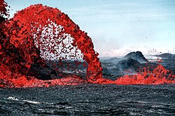
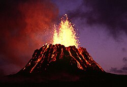
Also unlike other eruptive types, Hawaiian eruptions often occur at decentralized fissure vents, beginning with large "curtains of fire" that quickly die down and concentrate at specific locations on the volcano's rift zones. Central-vent eruptions, meanwhile, often take the form of large lava fountains (both continuous and sporadic), which can reach heights of hundreds of meters or more. The particles from lava fountains usually cool in the air before hitting the ground, resulting in the accumulation of cindery scoria fragments; however, when the air is especially thick with pyroclasts, they cannot cool off fast enough because of the surrounding heat, and hit the ground still hot, accumulating into spatter cones. If eruptive rates are high enough, they may even form splatter-fed lava flows. Hawaiian eruptions are often extremely long-lived; Puʻu ʻŌʻō, a cinder cone of Kīlauea, erupted continuously from January 3, 1983, until April 2018. [19]

Flows from Hawaiian eruptions can be divided into two types by their structural characteristics: pāhoehoe lava which is relatively smooth and flows with a ropey texture, and ʻaʻā flows which are denser, more viscous (and thus slower moving) and blockier. These lava flows can be anywhere between 2 and 20 m (10 and 70 ft) thick. ʻAʻā lava flows move through pressure the partially solidified front of the flow steepens because of the mass of flowing lava behind it until it breaks off, after which the general mass behind it moves forward. Though the top of the flow quickly cools down, the molten underbelly of the flow is buffered by the solidifying rock above it, and by this mechanism, ʻaʻā flows can sustain movement for long periods of time. Pāhoehoe flows, in contrast, move in more conventional sheets, or by the advancement of lava "toes" in snaking lava columns. Increasing viscosity on the part of the lava or shear stress on the part of local topography can morph a pāhoehoe flow into an ʻaʻā one, but the reverse never occurs. [23]

Although most shield volcanoes are by volume almost entirely Hawaiian and basaltic in origin, they are rarely exclusively so. Some volcanoes, such as Mount Wrangell in Alaska and Cofre de Perote in Mexico, exhibit large enough swings in their historical magmatic eruptive characteristics to cast strict categorical assignment in doubt; one geological study of de Perote went so far as to suggest the term "compound shield-like volcano" instead. [24] Most mature shield volcanoes have multiple cinder cones on their flanks, the results of tephra ejections common during incessant activity and markers of currently and formerly active sites on the volcano. [11] [19] An example of these parasitic cones is at Puʻu ʻŌʻō on Kīlauea [20] continuous activity ongoing since 1983 has built up a 2,290 ft (698 m) tall cone at the site of one of the longest-lasting rift eruptions in known history. [25]

The Hawaiian shield volcanoes are not located near any plate boundaries; the volcanic activity of this island chain is distributed by the movement of the oceanic plate over an upwelling of magma known as a hotspot. Over millions of years, the tectonic movement that moves continents also creates long volcanic trails across the seafloor. The Hawaiian and Galápagos shields, and other hotspot shields like them, are constructed of oceanic island basalt. Their lavas are characterized by high levels of sodium, potassium, and aluminium. [26]

Features common in shield volcanism include lava tubes. [27] Lava tubes are cave-like volcanic straights formed by the hardening of overlaying lava. These structures help further the propagation of lava, as the walls of the tube insulate the lava within. [28] Lava tubes can account for a large portion of shield volcano activity; for example, an estimated 58% of the lava forming Kīlauea comes from lava tubes. [27]

In some shield volcano eruptions, basaltic lava pours out of a long fissure instead of a central vent, and shrouds the countryside with a long band of volcanic material in the form of a broad plateau. Plateaus of this type exist in Iceland, Washington, Oregon, and Idaho; the most prominent ones are situated along the Snake River in Idaho and the Columbia River in Washington and Oregon, where they have been measured to be over 1 mi (2 km) in thickness. [12]

Calderas are a common feature on shield volcanoes. They are formed and reformed over the volcano's lifespan. Long eruptive periods form cinder cones, which then collapse over time to form calderas. The calderas are often filled up by progressive eruptions, or formed elsewhere, and this cycle of collapse and regeneration takes place throughout the volcano's lifespan. [11]

Interactions between water and lava at shield volcanoes can cause some eruptions to become hydrovolcanic. These explosive eruptions are drastically different from the usual shield volcanic activity [11] and are especially prevalent at the waterbound volcanoes of the Hawaiian Isles. [19]

Distribution

Shield volcanoes are found worldwide. They can form over hotspots (points where magma from below the surface wells up), such as the Hawaiian–Emperor seamount chain and the Galápagos Islands, or over more conventional rift zones, such as the Icelandic shields and the shield volcanoes of East Africa. Although shield volcanoes are not usually associated with subduction, they can occur over subduction zones. Many examples are found in California and Oregon, including Prospect Peak in Lassen Volcanic National Park, as well as Pelican Butte and Belknap Crater in Oregon. Many shield volcanoes are found in ocean basins, such as Kīlauea in Hawaii, although they can be found inland as wellEast Africa being one example of this. [29]

Hawaiian–Emperor seamount chain

The largest and most prominent shield volcano chain in the world is the Hawaiian–Emperor seamount chain, a chain of hotspot volcanoes in the Pacific Ocean. The volcanoes follow a distinct evolutionary pattern of growth and death. [30] The chain contains at least 43 major volcanoes, and Meiji Seamount at its terminus near the Kuril–Kamchatka Trench is 85 million years old. [31]

The youngest part of the chain is Hawaii, where the volcanoes are characterized by frequent rift eruptions, their large size (thousands of km3 in volume), and their rough, decentralized shape. Rift zones are a prominent feature on these volcanoes and account for their seemingly random volcanic structure. [7] They are fueled by the movement of the Pacific Plate over the Hawaii hotspot and form a long chain of volcanoes, atolls, and seamounts 2,600 km (1,616 mi) long with a total volume of over 750,000 km3 (179,935 cu mi). [32]

The chain includes Mauna Loa, a shield volcano which stands 4,170 m (13,680 ft) above sea level and reaches a further 13 km (8 mi) below the waterline and into the crust, approximately 80,000 km3 (19,000 cu mi) of rock. [27] Kīlauea, another Hawaiian shield volcano, is one of the most active volcanoes on Earth, with its most recent eruption occurring in 2021. [12]

Galápagos Islands

The Galápagos Islands are an isolated set of volcanoes, consisting of shield volcanoes and lava plateaus, about 1,100 km (680 mi) west of Ecuador. They are driven by the Galápagos hotspot, and are between approximately 4.2 million and 700,000 years of age. [26] The largest island, Isabela, consists of six coalesced shield volcanoes, each delineated by a large summit caldera. Española, the oldest island, and Fernandina, the youngest, are also shield volcanoes, as are most of the other islands in the chain. [33] [34] [35] The Galápagos Islands are perched on a large lava plateau known as the Galápagos Platform. This platform creates a shallow water depth of 360 to 900 m (1,181 to 2,953 ft) at the base of the islands, which stretch over a 174 mi (280 km) diameter. [36] Since Charles Darwin's visit to the islands in 1835 during the second voyage of HMS Beagle, there have been over 60 recorded eruptions in the islands, from six different shield volcanoes. [33] [35] Of the 21 emergent volcanoes, 13 are considered active. [26]

Cerro Azul is a shield volcano on the southwestern part of Isabela Island and is one of the most active in the Galapagos, with the last eruption between May and June 2008. The Geophysics Institute at the National Polytechnic School in Quito houses an international team of seismologists and volcanologists [37] whose responsibility is to monitor Ecuador's numerous active volcanoes in the Andean Volcanic Belt and the Galapagos Islands. La Cumbre is an active shield volcano on Fernandina Island that has been erupting since April 11, 2009. [38]

The Galápagos islands are geologically young for such a big chain, and the pattern of their rift zones follows one of two trends, one north-northwest, and one east–west. The composition of the lavas of the Galápagos shields are strikingly similar to those of the Hawaiian volcanoes. Curiously, they do not form the same volcanic "line" associated with most hotspots. They are not alone in this regard; the Cobb–Eickelberg Seamount chain in the North Pacific is another example of such a delineated chain. In addition, there is no clear pattern of age between the volcanoes, suggesting a complicated, irregular pattern of creation. How the islands were formed remains a geological mystery, although several theories have been proposed. [39]

Iceland

Skjaldbreidur is a shield volcano in Iceland, whose name means broad shield in Icelandic. Skjaldbreidur Herbst 2004.jpg
Skjaldbreiður is a shield volcano in Iceland, whose name means broad shield in Icelandic.

Located over the Mid-Atlantic Ridge, a divergent tectonic plate boundary in the middle of the Atlantic Ocean, Iceland is the site of about 130 volcanoes of various types. [20] Icelandic shield volcanoes are generally of Holocene age, between 5,000 and 10,000 years old. The volcanoes are also very narrow in distribution, occurring in two bands in the West and North Volcanic Zones. Like Hawaiian volcanoes, their formation initially begins with several eruptive centers before centralizing and concentrating at a single point. The main shield then forms, burying the smaller ones formed by the early eruptions with its lava. [36]

Icelandic shields are mostly small (~15 km3 (4 cu mi)), symmetrical (although this can be affected by surface topography), and characterized by eruptions from summit calderas. [36] They are composed of either tholeiitic olivine or picritic basalt. The tholeiitic shields tend to be wider and shallower than the picritic shields. [40] They do not follow the pattern of caldera growth and destruction that other shield volcanoes do; caldera may form, but they generally do not disappear. [7] [36]

Turkey

Bingöl Mountains are one of the shield volcanoes in Turkey.

East Africa

In East Africa, volcanic activity is generated by the development of the East African Rift and from nearby hotspots. Some volcanoes interact with both. Shield volcanoes are found near the rift and off the coast of Africa, although stratovolcanoes are more common. Although sparsely studied, the fact that all of its volcanoes are of Holocene age reflects how young the volcanic center is. One interesting characteristic of East African volcanism is a penchant for the formation of lava lakes; these semi-permanent lava bodies, extremely rare elsewhere, form in about 9% of African eruptions. [41]

The most active shield volcano in Africa is Nyamuragira. Eruptions at the shield volcano are generally centered within the large summit caldera or on the numerous fissures and cinder cones on the volcano's flanks. Lava flows from the most recent century extend down the flanks more than 30 km (19 mi) from the summit, reaching as far as Lake Kivu. Erta Ale in Ethiopia is another active shield volcano and one of the few places in the world with a permanent lava lake, which has been active since at least 1967, and possibly since 1906. [41] Other volcanic centers include Menengai, a massive shield caldera, [42] and Mount Marsabit in Kenya.

Extraterrestrial shield volcanoes

Scaled image showing Olympus Mons, top, and the Hawaiian island chain, bottom. Martian volcanoes are far larger than those found on Earth. Olympus Mons and Hawaii to scale.png
Scaled image showing Olympus Mons, top, and the Hawaiian island chain, bottom. Martian volcanoes are far larger than those found on Earth.

Shield volcanoes are not limited to Earth; they have been found on Mars, Venus, and Jupiter's moon, Io. [43]

The shield volcanoes of Mars are very similar to the shield volcanoes on Earth. On both planets, they have gently sloping flanks, collapse craters along their central structure, and are built of highly fluid lavas. Volcanic features on Mars were observed long before they were first studied in detail during the 1976–1979 Viking mission. The principal difference between the volcanoes of Mars and those on Earth is in terms of size; Martian volcanoes range in size up to 14 mi (23 km) high and 370 mi (595 km) in diameter, far larger than the 6 mi (10 km) high, 74 mi (119 km) wide Hawaiian shields. [44] [45] [46] The highest of these, Olympus Mons, is the tallest known mountain on any planet in the solar system.

Venus has over 150 shield volcanoes which are much flatter, with a larger surface area than those found on Earth, some having a diameter of more than 700 km (430 mi). [47] Although the majority of these are long extinct it has been suggested, from observations by the Venus Express spacecraft, that many may still be active. [48]

Related Research Articles

<span class="mw-page-title-main">Volcano</span> Rupture in a planets crust where material escapes

A volcano is a rupture in the crust of a planetary-mass object, such as Earth, that allows hot lava, volcanic ash, and gases to escape from a magma chamber below the surface.

<span class="mw-page-title-main">Mauna Loa</span> Volcano in Hawaii, United States

Mauna Loa is one of five volcanoes that form the Island of Hawaii in the U.S. state of Hawaii in the Pacific Ocean. Mauna Loa is Earth's largest active volcano by both mass and volume. It was historically considered to be the largest volcano on Earth until Tamu Massif was discovered to be larger. Mauna Loa is a shield volcano with relatively gentle slopes, and a volume estimated at 18,000 cubic miles (75,000 km3), although its peak is about 125 feet (38 m) lower than that of its neighbor, Mauna Kea. Lava eruptions from Mauna Loa are silica-poor and very fluid, and tend to be non-explosive.

<span class="mw-page-title-main">Kīlauea</span> Active volcano in Hawaii

Kīlauea is an active shield volcano in the Hawaiian Islands. It is located along the southeastern shore of Hawaii Island. The volcano is between 210,000 and 280,000 years old and grew above sea level about 100,000 years ago. Since the islands were settled it has been the most active of the five volcanoes that together form the island.

<span class="mw-page-title-main">Volcanism of Iceland</span>

Iceland experiences frequent volcanic activity, due to its location both on the Mid-Atlantic Ridge, a divergent tectonic plate boundary, and being over a hot spot. Nearly thirty volcanoes are known to have erupted in the Holocene epoch; these include Eldgjá, source of the largest lava eruption in human history. Some of the various eruptions of lava, gas and ash have been both destructive of property and deadly to life over the years, as well as disruptive to local and European air travel.

<span class="mw-page-title-main">Medicine Lake Volcano</span> Shield volcano in northeastern California, United States

Medicine Lake Volcano is a large shield volcano in northeastern California about 30 mi (50 km) northeast of Mount Shasta. The volcano is located in a zone of east-west crustal extension east of the main axis of the Cascade Volcanic Arc and the Cascade Range. The 0.6 mi (1 km) thick shield is 22 mi (35 km) from east to west and 28 to 31 mi from north to south, and covers more than 770 sq mi (2,000 km2). The underlying rock has downwarped by 0.3 mi (0.5 km) under the center of the volcano. The volcano is primarily composed of basalt and basaltic andesite lava flows, and has a 4.3 by 7.5 mi caldera at the center.

<span class="mw-page-title-main">National Park of American Samoa</span> United States national park in American Samoa

The National Park of American Samoa is a national park in the United States territory of American Samoa, distributed across four islands: Tutuila, Ofu, Olosega, and Ta‘ū. The park preserves and protects coral reefs, tropical rainforests, fruit bats, and the Samoan culture. Popular activities include hiking and snorkeling. Of the park's 8,257 acres (3,341 ha), 2,500 acres (1,000 ha) is coral reefs and ocean. The park is the only American National Park Service system unit south of the equator.

<span class="mw-page-title-main">Anahim Volcanic Belt</span> Chain of volcanoes and related magmatic features in British Columbia, Canada

The Anahim Volcanic Belt (AVB) is a west–east trending chain of volcanoes and related magmatic features in British Columbia, Canada. It extends from Athlone Island on the Central Coast, running eastward through the strongly uplifted and deeply dissected Coast Mountains to near the community of Nazko on the Interior Plateau. The AVB is delineated as three west-to-east segments that differ in age and structure. A wide variety of igneous rocks with differing compositions occur throughout these segments, comprising landforms such as volcanic cones, volcanic plugs, lava domes, shield volcanoes and intrusions.

<span class="mw-page-title-main">Evolution of Hawaiian volcanoes</span> Processes of growth and erosion of the volcanoes of the Hawaiian islands

The fifteen volcanoes that make up the eight principal islands of Hawaii are the youngest in a chain of more than 129 volcanoes that stretch 5,800 kilometers (3,600 mi) across the North Pacific Ocean, called the Hawaiian–Emperor seamount chain. Hawaiʻi's volcanoes rise an average of 4,600 meters (15,000 ft) to reach sea level from their base. The largest, Mauna Loa, is 4,169 meters (13,678 ft) high. As shield volcanoes, they are built by accumulated lava flows, growing a few meters or feet at a time to form a broad and gently sloping shape.

<span class="mw-page-title-main">Active volcano</span> Geological feature

An active volcano is a volcano that has erupted during the Holocene, is currently erupting, or has the potential to erupt in the future. A volcano that is not currently erupting but could erupt in the future is known as a dormant volcano. Volcanoes that will not erupt again are known as extinct volcanoes.

<span class="mw-page-title-main">Hawaiian eruption</span> Effusive volcanic eruption

A Hawaiian eruption is a type of volcanic eruption where lava flows from the vent in a relatively gentle, low level eruption; it is so named because it is characteristic of Hawaiian volcanoes. Typically they are effusive eruptions, with basaltic magmas of low viscosity, low content of gases, and high temperature at the vent. Very small amounts of volcanic ash are produced. This type of eruption occurs most often at hotspot volcanoes such as Kīlauea on Hawaii's big island and in Iceland, though it can occur near subduction zones and rift zones. Hawaiian eruptions may occur along fissure vents, such as during the eruption of Mauna Loa in 1950, or at a central vent, such as during the 1959 eruption in Kīlauea Iki Crater, which created a lava fountain 580 meters (1,900 ft) high and formed a 38-meter cone named Puʻu Puaʻi. In fissure-type eruptions, lava spurts from a fissure on the volcano's rift zone and feeds lava streams that flow downslope. In central-vent eruptions, a fountain of lava can spurt to a height of 300 meters or more.

<span class="mw-page-title-main">Types of volcanic eruptions</span> Overview of different types of volcanic eruptions

Several types of volcanic eruptions—during which material is expelled from a volcanic vent or fissure—have been distinguished by volcanologists. These are often named after famous volcanoes where that type of behavior has been observed. Some volcanoes may exhibit only one characteristic type of eruption during a period of activity, while others may display an entire sequence of types all in one eruptive series.

<span class="mw-page-title-main">Volcanism of Canada</span> Volcanic activity in Canada

Volcanic activity is a major part of the geology of Canada and is characterized by many types of volcanic landform, including lava flows, volcanic plateaus, lava domes, cinder cones, stratovolcanoes, shield volcanoes, submarine volcanoes, calderas, diatremes, and maars, along with less common volcanic forms such as tuyas and subglacial mounds.

<span class="mw-page-title-main">Geology of the Pacific Northwest</span> Geology of Oregon and Washington (United States) and British Columbia (Canada)

The geology of the Pacific Northwest includes the composition, structure, physical properties and the processes that shape the Pacific Northwest region of North America. The region is part of the Ring of Fire: the subduction of the Pacific and Farallon Plates under the North American Plate is responsible for many of the area's scenic features as well as some of its hazards, such as volcanoes, earthquakes, and landslides.

<span class="mw-page-title-main">Hawaii hotspot</span> Volcanic hotspot near the Hawaiian Islands, in the Pacific Ocean

The Hawaiʻi hotspot is a volcanic hotspot located near the namesake Hawaiian Islands, in the northern Pacific Ocean. One of the best known and intensively studied hotspots in the world, the Hawaii plume is responsible for the creation of the Hawaiian–Emperor seamount chain, a 6,200-kilometer (3,900 mi) mostly undersea volcanic mountain range. Four of these volcanoes are active, two are dormant; more than 123 are extinct, most now preserved as atolls or seamounts. The chain extends from south of the island of Hawaiʻi to the edge of the Aleutian Trench, near the eastern coast of Russia.

<span class="mw-page-title-main">Chain of Craters Road</span> Road in Hawaii

Chain of Craters Road is a 19-mile (31 km) long winding paved road through the East Rift and coastal area of the Hawaii Volcanoes National Park on the island of Hawaii, in the state of Hawaii, United States. The original road, built in 1928, connected Crater Rim Drive to Makaopuhi Crater. The road was lengthened to reach the tiny town of Kalapana in 1959. As of 2018, the road has had parts covered by lava in 41 of the past 53 years, due to eruptions of Kīlauea volcano.

<span class="mw-page-title-main">Lava</span> Molten rock expelled by a volcano during an eruption

Lava is molten or partially molten rock (magma) that has been expelled from the interior of a terrestrial planet or a moon onto its surface. Lava may be erupted at a volcano or through a fracture in the crust, on land or underwater, usually at temperatures from 800 to 1,200 °C. The volcanic rock resulting from subsequent cooling is also often called lava.

<span class="mw-page-title-main">Volcanism of Eastern Canada</span>

The volcanism of Eastern Canada includes the hundreds of volcanic areas and extensive lava formations in Eastern Canada. The region's different volcano and lava types originate from different tectonic settings and types of volcanic eruptions, ranging from passive lava eruptions to violent explosive eruptions. Eastern Canada has very large volumes of magmatic rock called large igneous provinces. They are represented by deep-level plumbing systems consisting of giant dike swarms, sill provinces and layered intrusions. The most capable large igneous provinces in Eastern Canada are Archean age greenstone belts containing a rare volcanic rock called komatiite.

<span class="mw-page-title-main">Volcanic history of the Northern Cordilleran Volcanic Province</span>

The volcanic history of the Northern Cordilleran Volcanic Province presents a record of volcanic activity in northwestern British Columbia, central Yukon and the U.S. state of easternmost Alaska. The volcanic activity lies in the northern part of the Western Cordillera of the Pacific Northwest region of North America. Extensional cracking of the North American Plate in this part of North America has existed for millions of years. Continuation of this continental rifting has fed scores of volcanoes throughout the Northern Cordilleran Volcanic Province over at least the past 20 million years and occasionally continued into geologically recent times.

<span class="mw-page-title-main">Volcanoes of the Galápagos Islands</span>

The Galápagos Islands are an isolated set of volcanoes, consisting of shield volcanoes and lava plateaus, located 1,200 km (746 mi) west of Ecuador. They are driven by the Galápagos hotspot, and are between 4.2 million and 700,000 years of age. The largest island, Isabela, consists of six coalesced shield volcanoes, each delineated by a large summit caldera. Española, the oldest island, and Fernandina, the youngest, are also shield volcanoes, as are most of the other islands in the chain. The Galápagos Islands are perched on a large lava plateau known as the Galápagos Platform, which creates a shallow-water depth of 360 to 900 m at the base of the islands, which stretch over a 174 mi (280 km)-long diameter. Since Charles Darwin's famous visit to the islands in 1835, over 60 recorded eruptions have occurred in the islands, from six different shield volcanoes. Of the 21 emergent volcanoes, 13 are considered active.

<span class="mw-page-title-main">North Arch volcanic field</span> Underwater volcanic field north of Oahu, Hawaii

North Arch volcanic field is an underwater volcanic field north of Oahu, Hawaii. It covers an area of about 25,000 square kilometres (9,700 sq mi) and consists of large expanses of alkali basalt, basanite and nephelinite that form extensive lava flows and volcanic cones. Some lava flows are longer than 100 kilometres (62 mi).

References

  1. Schmincke, Hans-Ulrich (2003). Volcanism. Berlin: Springer. pp. 127–128. ISBN   9783540436508.
  2. Plescia, J. B. (2004). "Morphometric properties of Martian volcanoes". Journal of Geophysical Research. 109 (E3): E03003. Bibcode:2004JGRE..109.3003P. doi: 10.1029/2002JE002031 .
  3. Keddie, Susan T.; Head, James W. (1994). "Sapas Mons, Venus: evolution of a large shield volcano". Earth, Moon, and Planets. 65 (2): 129–190. Bibcode:1994EM&P...65..129K. doi:10.1007/BF00644896. S2CID   122532573.
  4. Douglas Harper (2010). "Shield volcano". Online Etymology Dictionary. Douglas Harper. Retrieved February 13, 2011.
  5. "Shield volcano" at Oxford English Dictionary
  6. 1 2 3 John Watson (1 March 2011). "Principal Types of Volcanoes". United States Geological Survey. Retrieved 30 December 2013.
  7. 1 2 3 4 5 6 7 8 9 "How Volcanoes Work: Shield Volcanoes". San Diego State University. Archived from the original on 2 January 2014. Retrieved 30 December 2013.
  8. "Purico Complex". Global Volcanism Program . Smithsonian Institution . Retrieved 30 December 2013.
  9. "Billy Mitchell". Global Volcanism Program . Smithsonian Institution . Retrieved 30 December 2013.
  10. Wood, Charles A.; Kienle, Jürgen (1990). Volcanoes of North America: United States and Canada. Cambridge, England: Cambridge University Press. p. 133. ISBN   0-521-43811-X.
  11. 1 2 3 4 "Shield Volcanoes". University of North Dakota. Archived from the original on 8 August 2007. Retrieved 22 August 2010.
  12. 1 2 3 4 5 6 Topinka, Lyn (28 December 2005). "Description: Shield Volcano". USGS. Retrieved 21 August 2010.
  13. J.G. Moore (1987). "Subsidence of the Hawaiian Ridge". Volcanism in Hawaii. Geological Survey Professional Paper. Vol. 1350.
  14. "How High is Mauna Loa?". Hawaiian Volcano Observatory – United States Geological Survey. 20 August 1998. Retrieved 5 February 2013.
  15. Navin Singh Khadka (28 February 2012). "Nepal in new bid to finally settle Mount Everest height". BBC News. Retrieved 10 December 2012.
  16. Brian Clark Howard (5 September 2013). "New Giant Volcano Below Sea Is Largest in the World". National Geographic. Archived from the original on September 6, 2013. Retrieved 31 December 2013.
  17. Sanger, W.; et al. (2019). "Oceanic plateau formation by seafloor spreading implied by Tamu Massif magnetic anomalies". Nature Geoscience. 12 (8): 661–666. Bibcode:2019NatGe..12..661S. doi:10.1038/s41561-019-0390-y.
  18. Hasenaka, T. (October 1994). "Size, distribution, and magma output rate for shield volcanoes of the Michoacán-Guanajuato volcanic field, Central Mexico". Journal of Volcanology and Geothermal Research . 63 (2): 13–31. Bibcode:1994JVGR...63...13H. doi:10.1016/0377-0273(94)90016-7.
  19. 1 2 3 4 5 "How Volcanoes Work: Hawaiian Eruptions". San Diego State University. Archived from the original on 3 March 2001. Retrieved 27 July 2014.
  20. 1 2 3 World Book: U  · V  · 20. Chicago: Scott Fetzer. 2009. pp. 438–443. ISBN   978-0-7166-0109-8 . Retrieved 22 August 2010.
  21. Marco Bagnardia; Falk Amelunga; Michael P. Poland (September 2013). "A new model for the growth of basaltic shields based on deformation of Fernandina volcano, Galápagos Islands". Earth and Planetary Science Letters . 377–378: 358–366. Bibcode:2013E&PSL.377..358B. doi:10.1016/j.epsl.2013.07.016.
  22. Regelous, M.; Hofmann, A. W.; Abouchami, W.; Galer, S. J. G. (2003). "Geochemistry of Lavas from the Emperor Seamounts, and the Geochemical Evolution of Hawaiian Magmatism from 85 to 42 Ma". Journal of Petrology. 44 (1): 113–140. Bibcode:2003JPet...44..113R. doi: 10.1093/petrology/44.1.113 .
  23. "How Volcanoes Work: Basaltic Lava". San Diego State University. Archived from the original on 8 October 2018. Retrieved 2 August 2010.
  24. Gerardo Carrasco-Núñeza; et al. (30 November 2010). "Evolution and hazards of a long-quiescent compound shield-like volcano: Cofre de Perote, Eastern Trans-Mexican Volcanic Belt". Journal of Volcanology and Geothermal Research . 197 (4): 209–224. Bibcode:2010JVGR..197..209C. doi:10.1016/j.jvolgeores.2009.08.010.
  25. "Summary of the Pu'u 'Ō 'ō-Kupaianaha Eruption, 1983-present". United States Geological Survey - Hawaii Volcano Observatory. 4 October 2008. Retrieved 5 February 2011.
  26. 1 2 3 Bill White & Bree Burdick. "Volcanic Galapagos: Formation of an Oceanic Archipelago". University of Oregon. Retrieved 23 February 2011.
  27. 1 2 3 "VHP Photo Glossary: Shield volcano". USGS. 17 July 2009. Retrieved 23 August 2010.
  28. Topinka, Lyn (18 April 2002). "Description: Lava Tubes and Lava Tube Caves". USGS. Retrieved 23 August 2010.
  29. James S. Monroe; Reed Wicander (2006). The changing Earth : exploring geology and evolution (5th ed.). Belmont, CA: Brooks/Cole. p. 115. ISBN   978-0-495-55480-6 . Retrieved February 22, 2011.
  30. "Evolution of Hawaiian Volcanoes". Hawaiian Volcano Observatory - United States Geological Survey. 8 September 1995. Retrieved 28 February 2011.
  31. Regelous, M.; Hofmann, A.W.; Abouchami, W.; Galer, S.J.G. (2003). "Geochemistry of Lavas from the Emperor Seamounts, and the Geochemical Evolution of Hawaiian Magmatism from 85 to 42 Ma" (PDF). Journal of Petrology . 44 (1): 113–140. Bibcode:2003JPet...44..113R. doi: 10.1093/petrology/44.1.113 . Archived from the original (PDF) on 19 July 2011. Retrieved 13 February 2011.
  32. Watson, Jim (5 May 1999). "The long trail of the Hawaiian hotspot". United States Geological Survey. Retrieved 13 February 2011.
  33. 1 2 "How Volcanoes Work: Galapagos Shield Volcanoes". San Diego State University. Archived from the original on 3 December 2010. Retrieved 22 February 2011.
  34. "Volcanoes". Galapagos Online Tours and Cruises. Archived from the original on 23 July 2001. Retrieved 22 February 2011.
  35. 1 2 "Volcanoes of South America: Galápagos Islands". Global Volcanism Program . Smithsonian National Museum of Natural History. Retrieved 22 February 2011.
  36. 1 2 3 4 Ruth Andrews & Agust Gudmundsson (2006). "Holocene shield volcanoes in Iceland" (PDF). University of Göttingen. Archived from the original (PDF) on 11 June 2007. Retrieved 21 February 2011.
  37. Institute for Geophysics at National Polytechnic School
  38. "Galapagos volcano erupts, could threaten wildlife". October 22, 2015. Archived from the original on 2009-04-15.
  39. Bailey, K. (30 April 1976). "Potassium-Argon Ages from the Galapagos Islands". Science . 192 (4238): 465–467. Bibcode:1976Sci...192..465B. doi:10.1126/science.192.4238.465. PMID   17731085. S2CID   11848528.
  40. Rossi, M. J. (1996). "Morphology and mechanism of eruption of postglacial shield volcanoes in Iceland". Bulletin of Volcanology . 57 (7): 530–540. Bibcode:1996BVol...57..530R. doi:10.1007/BF00304437. S2CID   129027679.
  41. 1 2 Lyn Topinka (2 October 2003). "Africa Volcanoes and Volcanics". United States Geological Survey. Retrieved 28 February 2011.
  42. "Menengai". Global Volcanism Program . Smithsonian National Museum of Natural History. Retrieved 28 February 2011.
  43. Heather Couper & Nigel Henbest (1999). Space Encyclopedia . Dorling Kindersley. ISBN   978-0-7894-4708-1.
  44. Watson, John (February 5, 1997). "Extraterrestrial Volcanism". United States Geological Survey. Retrieved February 13, 2011.
  45. Masursky, H.; Masursky, Harold; Saunders, R. S. (1973). "An Overview of Geological Results from Mariner 9". Journal of Geophysical Research . 78 (20): 4009–4030. Bibcode:1973JGR....78.4031C. doi:10.1029/JB078i020p04031.
  46. Carr, M.H., 2006, The Surface of Mars, Cambridge, 307 p.
  47. "Large Shield Volcanoes". Oregon State University. Archived from the original on January 5, 2018. Retrieved April 14, 2011.
  48. Nancy Atkinson (8 April 2010). "Volcanoes on Venus May Still Be Active". Universe Today . Retrieved April 14, 2011.