
This is a list of the rivers of Serbia , either those flowing entirely or partially within Serbia proper, or just being a border rivers.
This is a list of the rivers of Serbia , either those flowing entirely or partially within Serbia proper, or just being a border rivers.
All rivers in Serbia belong to the drainage basins of three seas: Black Sea, Adriatic Sea or Aegean Sea.
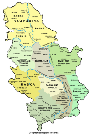
The largest in area, Black Sea drainage basin, covers an area of 81,261 km2 or 92% of the territory of Serbia. The entire basin is drained by only one river, the Danube, which flows into the Black Sea. All major rivers in Serbia, like Tisa, Sava, Velika Morava and Drina belong to it.
The Adriatic Sea drainage basin covers an area of 4,500 km2 or 5% of territory of Serbia. It comprises the western half of the Kosovo and Metohija and it is mostly drained by one river, the White Drin, which in Albania meets the Black Drin to create the Drin river, which flows into the Adriatic Sea. Smaller portion of it is drained by Crni Kamen-Radika river in the extreme southern region of Gora, which also drains into Black Drin in North Macedonia.
The Aegean Sea basin is the smallest in area, 2,650 km2 or 3% of the territory of Serbia, and covers the southern parts of Serbia, to the Macedonian and Bulgarian borders. It is drained by three rivers: Lepenac, Pčinja and Dragovištica. The first two flow into the Vardar river in North Macedonia, and the third flows into the Struma river in Bulgaria, and both of those rivers flow into the Aegean Sea.
All three basins meet at the Drmanska glava peak on the Crnoljeva mountain in central Kosovo, which represents the water divide of Serbia and the major one in the Balkans, as it divides three out of the Balkan's four drainage basins (the fourth being the Ionian Sea).
The lengths in the table present the overall lengths of the rivers, not just the Serbian parts of the flow. In the first table, rivers over 50 km are listed, including river systems (such as Great Morava) created by confluence of other major rivers; in those cases, the length is given as the total of the river and the longer headstream.
Selected list of shorter rivers is added below the two tables.
| Name | Cyrillic | Length (km) | Drainage area (km2) | Drainage basin (sea) | length measured as: | Main tributary (in Serbia) | Provinces within Serbia | Countries sharing the same river | |
|---|---|---|---|---|---|---|---|---|---|
| 1. | Danube | Дунав | 2888 | 817000 | Black | Breg-Danube | Tisa | Vojvodina, Central Serbia | Germany, Austria, Slovakia, Hungary, Croatia, Romania, Bulgaria, Ukraine |
| 2. | Tisa | Тиса | 1026 | 157020 | Black | Black Tisa-Tisa | Begej | Vojvodina | Ukraine, Romania, Hungary |
| 3. | Sava | Сава | 990 | 95719 | Black | Sava Dolinka-Sava | Drina | Vojvodina, Central Serbia | Slovenia, Croatia, Bosnia and Herzegovina |
| 4. | Velika Morava (Great Morava) | Велика Морава | 493 | 35419 | Black | Golijska Moravica-Zapadna Morava-Velika Morava | Južna Morava | Central Serbia | none |
| 5. | Drina | Дрина | 487 | 19570 | Black | Tara-Drina | Lim | Central Serbia | Montenegro, Bosnia and Herzegovina |
| 6. | Tamiš | Тамиш | 359 | 13085 | Black | regular | Brzava | Vojvodina | Romania |
| 7. | Drin | Дрим | 335 | 11756 | Adriatic | White Drin-Drin | Klina | Kosovo | Albania |
| 8. | Južna Morava (South Morava) | Јужна Морава | 295 | 15469 | Black | Golema-Binačka Morava-Južna Morava | Nišava | Kosovo, Central Serbia | North Macedonia |
| 9. | Ibar | Ибар | 276 | 8059 | Black | regular | Sitnica | Central Serbia, Kosovo | Montenegro |
| 10. | Begej | Бегеј | 254 | 2878 | Black | regular | Novi Begej | Vojvodina | Romania |
| 11. | Lim | Лим | 220 | 5963 | Black | Vrmoša-Luča-Lake Plav-Lim | Uvac | Central Serbia | Montenegro, Albania, Bosnia and Herzegovina |
| 12. | Nišava | Нишава | 218 | 3950 | Black | regular | Temštica | Central Serbia | Bulgaria |
| 13. | Timok | Тимок | 203 | 4630 | Black | Svrljiški Timok-Beli Timok-Timok | Crni Timok | Central Serbia | Bulgaria |
| 14. | Bosut | Босут | 186 | 3097 | Black | Biđ-Bosut | Studva | Vojvodina | Croatia |
| 15. | Brzava | Брзава | 166 | 1190 | Black | regular | minor flows | Vojvodina | Romania |
| 16. | Toplica | Топлица | 130 | 2600 | Black | Duboka-Toplica | Kosanica | Central Serbia | none |
| 17. | Pek | Пек | 129 | 1236 | Black | Lipa-Pek | Jagnjilo | Central Serbia | none |
| 18. | Plazović | Плазовић | 129 | Black | regular | minor flows | Vojvodina | Hungary | |
| 19. | Pčinja | Пчиња | 128 | 3140 | Aegean | regular | minor flows | Central Serbia | North Macedonia |
| 20. | Nera | Нера | 124 | 1420 | Black | regular | minor flows | Vojvodina | Romania |
| 21. | Kolubara | Колубара | 123 | 3639 | Black | Obnica-Kolubara | Tamnava | Central Serbia | none |
| 22. | Uvac | Увац | 119 | 1095 | Black | Rasanska reka-Vapa-Uvac | Tisnica | Central Serbia | Bosnia and Herzegovina |
| 23. | Mlava | Млава | 118 | 1210 | Black | Tisnica-Mlava | Vitovnica | Central Serbia | None |
| 24. | Karaš | Караш | 110 | 1400 | Black | regular | Ilidija | Vojvodina | Romania |
| 25. | Krivaja (Bačka) | Криваја | 109 | 956 | Black | regular | minor flows | Vojvodina | none |
| 26. | Čik | Чик | 95 | 481 | Black | regular | none | Vojvodina | none |
| 27. | Rasina | Расина | 92 | 994 | Black | regular | minor flows | Central Serbia | none |
| 28. | Sitnica | Ситница | 90 | 3129 | Black | regular | Lab | Kosovo | none |
| 29. | Tamnava | Тамнава | 90 | 930 | Black | regular | Ub | Central Serbia | none |
| 30. | Kereš | Кереш | 90 | 976 | Black | regular | none | Vojvodina | Hungary |
| 31. | Temštica | Темштица | 86 | 820 | Black | Visočica-Temštica | Dojkinička reka | Central Serbia | Bulgaria |
| 32. | Jablanica | Јабланица | 85 | 895 | Black | regular | Čokotinska reka | Central Serbia | none |
| 33. | Crni Timok | Црни Тимок | 84 | 1003 | Black | regular | Zlotska reka | Central Serbia | none |
| 34. | Nadela | Надела | 84 | Black | regular | minor flows | Vojvodina | none | |
| 35. | Jasenica | Јасеница | 79 | 1343 | Black | regular | Kubršnica | Central Serbia | none |
| 36. | Jadar | Јадар | 79 | 894 | Black | regular | Rakovica | Central Serbia | none |
| 37. | Gruža | Гружа | 77 | 622 | Black | regular | Kotlenjača | Central Serbia | none |
| 38. | Lepenac | Лепенац | 75 | 770 | Aegean | regular | Nerodimka | Kosovo | North Macedonia |
| 39. | Đetinja | Ђетиња | 75 | 1486 | Black | regular | Skrapež | Central Serbia | none |
| 40. | Veternica | Ветерница | 75 | 515 | Black | regular | Sušica | Central Serbia | none |
| 41. | Jerma | Јерма | 74 | Black | regular | Zvonačka reka | Central Serbia | Bulgaria | |
| 42. | Lab | Лаб | 72 | 950 | Black | regular | Kačandolska reka | Kosovo | none |
| 43. | Rzav (Drina) | Рзав | 72 | 605 | Black | Black Rzav-Rzav | White Rzav | Central Serbia | Bosnia and Herzegovina |
| 44. | Pusta reka (Južna Morava) | Пуста река | 71 | 569 | Black | Golema-Pusta reka | minor flows | Central Serbia | none |
| 45. | Mostonga | Мостонга | 70 | Black | regular | none | Vojvodina | none | |
| 46. | Radika | Радика | 70 | 665 | Adriatic | Crni Kamen-Ćafa Kadis-Radika | minor flows | Central Serbia | North Macedonia |
| 47. | Galacka | Галацка | 69 | 843 | Black | regular | minor flows | Vojvodina | none |
| 48. | Vlasina | Власина | 68 | 1050 | Black | regular | Lužnica | Central Serbia | none |
| 49. | Resava | Ресава | 65 | 685 | Black | regular | none | Central Serbia | none |
| 50. | Jegrička | Јегричка | 65 | Black | regular | none | Vojvodina | none | |
| 51. | Dragovištica | Драговиштица | 63 | Aegean | Mutnica-Božička reka-Dragovištica | Ljubatska reka | Central Serbia | Bulgaria | |
| 52. | Pećka Bistrica (Peć Bistrica) | Пећка Бистрица | 62 | 505 | Adriatic | regular | minor flows | Kosovo | Montenegro |
| 53. | Klina | Клина | 62 | 393 | Adriatic | regular | Move | Kosovo | none |
| 54. | Rzav (Golija) | Рзав | 61 | 575 | Black | Veliki Rzav-Rzav | Mali Rzav | Central Serbia | none |
| 55. | Studenica | Студеница | 60 | 582 | Black | Crna reka-Studenica | Brusnička reka | Central Serbia | none |
| 56. | Raška | Рашка | 60 | 1193 | Black | regular | Deževska reka | Central Serbia | none |
| 57. | Sokobanjska Moravica | Сокобањска Моравица | 58 | 606 | Black | regular | minor flows | Central Serbia | none |
| 58. | Ub | Уб | 57 | 274 | Black | regular | minor flows | Central Serbia | none |
| 59. | Lugomir | Лугомир | 57 | 447 | Black | Dulenska reka-Lugomir | Županjevačka reka | Central Serbia | none |
| 60. | Jerez | Јерез | 56 | 503 | Black | regular | minor flows | Central Serbia | none |
| 61. | Jasenička reka | Јасеничка река | 55 | Black | Vrelska reka-Jasenička reka | minor flows | Central Serbia | none | |
| 62. | Dečanska Bistrica (Dečani Bistrica) | Дечанска Бистрица | 53 | 300 | Adriatic | Kožnjarska Bistrica-Dečanska Bistrica | Kožnjarska Bistrica | Kosovo | none |
| 63. | Jarčina | Јарчина | 53 | Black | Međeš-Progarska Jarčina | minor flows | Vojvodina, Central Serbia | none | |
| 64. | Budovar | Будовар | 52 | Black | Patka-Budovar | minor flows | Vojvodina | none | |
| 65. | Drenica | Дреница | 51 | 447 | Black | regular | Vrbovačka reka | Kosovo | none |
| 66. | Ralja | Раља | 51 | 310 | Black | regular | minor flows | Central Serbia | none |
| 67. | Erenik | Ереник | 51 | 516 | Adriatic | regular | Loćanska Bistrica | Kosovo | none |
| 68. | Porečka reka | Поречка река | 50 | 538 | Black | Šaška-Porečka | Crnajka | Central Serbia | none |
| 69. | Trgoviški Timok | Трговишки Тимок | 50 | 520 | Black | Strma reka-Trgoviški Timok | Žukovska reka | Central Serbia | none |
Some rivers, historically with different names, are already included in the length of other rivers, but exist as separate rivers in topography or tradition. The most prominent ones are listed below.
| Name | Cyrillic | Length (km) | Drainage area (km2) | Drainage basin (sea) | length measured as: | Main tributary | Provinces within Serbia | Included in: | |
|---|---|---|---|---|---|---|---|---|---|
| 1. | Zapadna Morava (West Morava) | Западна Морава | 308 | 15849 | Black | Golijska Moravica-West Morava | Ibar | Central Serbia | Great Morava |
| 2. | White Drin | Бели Дрим | 175 | 4300 | Adriatic | regular | Klina | Kosovo | Drin |
| 3. | Beli Timok | Бели Тимок | 115 | 2167 | Black | Svrljiški Timok-White Timok | Trgoviški Timok | Central Serbia | Timok |
| 4. | Golijska Moravica | Голијска Моравица | 98 | 1486 | Black | regular | Ðetinja | Central Serbia | West and Great Morava |
| 5. | Visočica | Височица | 71 | Black | regular | Dojkinička reka | Central Serbia | Temštica | |
| 6. | Svrljiški Timok | Сврљишки Тимок | 64 | 720 | Black | regular | minor flows | Central Serbia | White Timok and Timok |
|
|
|
| History |
|  | |||||||||
|---|---|---|---|---|---|---|---|---|---|---|---|
| Geography | |||||||||||
| Politics |
| ||||||||||
| Economy |
| ||||||||||
| Society |
| ||||||||||

Bulgaria is a country situated in Southeast Europe that occupies the eastern quarter of the Balkan peninsula, being the largest country within its geographic boundaries. It borders Romania to the north, Serbia and North Macedonia to the west, Greece and Turkey to the south, and the Black Sea to the east. The northern border with Romania follows the river Danube until the city of Silistra. The land area of Bulgaria is 110,994 square kilometres (42,855 sq mi), slightly larger than that of Cuba, Iceland or the U.S. state of Tennessee. Considering its relatively compact territorial size and shape, Bulgaria has a great variety of topographical features. Even within small parts of the country, the land may be divided into plains, plateaus, hills, mountains, basins, gorges, and deep river valleys. The geographic center of Bulgaria is located in Uzana.

Albania is a country in Southeastern Europe that lies along the Adriatic and Ionian Seas, with a coastline spanning approximately 476 km (296 mi). Situated on the Balkan Peninsula, it is one of the most mountainous countries in Europe. It is bounded by Montenegro to the northwest, Kosovo to the northeast, North Macedonia to the east and Greece to the southeast and south.

North Macedonia is a country situated in southeastern Europe with geographic coordinates 41°50′N22°00′E, bordering Kosovo and Serbia to the north, Bulgaria to the east, Greece to the south and Albania to the west. The country is part of the wider region of Macedonia and makes up most of Vardar Macedonia. The country is a major transportation corridor from Western and Central Europe to Southern Europe and the Aegean Sea. North Macedonia is a landlocked country but has three major natural lakes: Lake Ohrid, Lake Prespa and Lake Dojran. It has a water area of 857 km2, while its land area is 24,856 km2.

The Vardar or Axios is the longest river in North Macedonia and a major river in Greece, where it reaches the Aegean Sea at Thessaloniki. It is 388 km (241 mi) long, out of which 76 km (47 mi) are in Greece, and drains an area of around 25,000 km2 (9,653 sq mi). The maximum depth of the river is 4 m (13 ft).
Serbia is a small country situated at the crossroads of Central and Southeast Europe, covering the far southern edges of the Pannonian Plain and the central Balkans. It shares borders with Bosnia and Herzegovina, Bulgaria, Croatia, Hungary, North Macedonia, Montenegro, and Romania. Serbia shares a contested border with Albania as it doesn't recognise the independence of Kosovo. Serbia is landlocked, though it is able to access the Adriatic Sea through Montenegro and inland Europe and the Black Sea via the Danube.
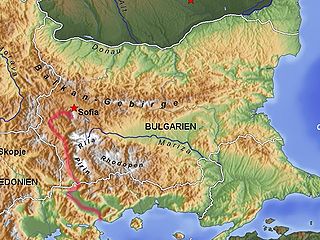
The Struma or Strymónas is a river in Bulgaria and Greece. Its ancient name was Strymṓn. Its drainage area is 17,330 km2 (6,690 sq mi), of which 8,670 km2 (3,350 sq mi) in Bulgaria, 6,295 km2 (2,431 sq mi) in Greece and the remaining 2,365 km2 (913 sq mi) in North Macedonia and Serbia. It takes its source from the Vitosha Mountain in Bulgaria, runs first westward, then southward, forming a number of gorges, enters Greece near the village of Promachonas in eastern Macedonia. In Greece it is the main waterway feeding and exiting from Lake Kerkini, a significant centre for migratory wildfowl. Also in Greece, the river entirely flows in the Serres regional unit into the Strymonian Gulf in Aegean Sea, near Amphipolis. The river's length is 415 kilometres (of which 290 kilometres in Bulgaria, making it the country's fifth-longest and one of the longest rivers that run solely in the interior of the Balkans.

The Great Morava is the final section of the Morava, a major river system in Serbia.

The Drin is a river in Southeastern Europe with two major tributaries – the White Drin and the Black Drin and two distributaries – one discharging into the Adriatic Sea, in the Gulf of Drin and the other into the Bojana River. Its catchment area extends across Albania, Kosovo, Serbia, Greece, Montenegro and North Macedonia and is home to more than 1.6 million people. The river and its tributaries form the Gulf of Drin, an ocean basin that encompasses the northern Albanian Adriatic Sea Coast.

The South Morava is a river in eastern Kosovo and in southern Serbia, which represents the shorter headwater of Great Morava. Today, it is 295 kilometres (183 mi) long, including its source river Binačka Morava. It flows generally in the south to north direction, from the Macedonian border to Kosovo and onwards to Central Serbia, where it meets West Morava at Stalać, to create Great Morava.

The Pčinja is a 135 km long river in Serbia and North Macedonia, a left tributary of the Vardar River.

The Lepenac is a river in southern Kosovo and northern North Macedonia, a 75 km (47 mi) long left tributary to the Vardar river.

The Lumbardhi i Pejës, or Peja Bistrica or Peć Bistrica, is a river in Kosovo. This 62 km-long right tributary to the White Drin river flows entirely within the south-western part of Kosovo.

The White Drin or White Drim is a river in Kosovo and northern Albania, a ca. 140-kilometre (87 mi) long headstream of the Drin.
Carraleva is a mountain in central Kosovo, dividing its two main geographical regions, the Kosovo Plain and Metohija. Carraleva is also a point where all three drainage basins of Kosovo meet, making the mountain a major hydrographic knot. It is named after the village of Carraleva.

The Nerodimka is a river in the Nerodime region of Kosovo, a 41 km-long left tributary to the Lepenc river. It represents Europe's only instance of a river bifurcation flowing into two seas, dividing into two irreversible branches. The left branch flows into the Black Sea, and the right branch flows into the Aegean Sea.

Radika is a river in southern Kosovo and western North Macedonia, a 70 km (43 mi)-long right tributary to the Black Drin river.

Kosovo is a small and landlocked country in Southeastern Europe. The country is strategically positioned in the center of the Balkan Peninsula enclosed by Montenegro to the west, Serbia to the north and east, North Macedonia to the southeast, and Albania to the southwest. It has no direct access to the Mediterranean Sea but its rivers flow into three seas, the Adriatic, Aegean and Black Sea.
Trekufiri, is a mountain located in the Albanian Alps and the Bogićevica range. Perched at 2,366 m (7,762 ft) above sea level, its summit marks the border where Albania, Kosovo, and Montenegro intersect. The height of the three-country point varies, with Albanian maps recording the mountain's height as 2,354 m (7,723 ft) above sea level while official Yugoslavian sources state it as 2366 m.

Prizren is located on the slopes of the Sharr Mountains in the southern part of Kosovo. The municipality has a border with Albania and North Macedonia.