
A state highway, state road, or state route is usually a road that is either numbered or maintained by a sub-national state or province. A road numbered by a state or province falls below numbered national highways in the hierarchy.
The Provincial Highway Network consists of all the roads in Ontario maintained by the Ministry of Transportation of Ontario (MTO), including those designated as part of the King's Highway, secondary highways, and tertiary roads. Components of the system—comprising 16,900 kilometres (10,500 mi) of roads and 2,880 bridges —range in scale from Highway 401, the busiest highway in North America, to unpaved forestry and mining access roads. The longest highway is nearly 2,000 kilometres (1,200 mi) long, while the shortest is less than a kilometre. Some roads are unsigned highways, lacking signage to indicate their maintenance by the MTO; these may be remnants of highways that are still under provincial control whose designations were decommissioned, roadway segments left over from realignment projects, or proposed highway corridors.
Highway 5 is a 543 km (337 mi) north–south route in southern British Columbia, Canada. Highway 5 connects the southern Trans-Canada route with the northern Trans-Canada/Yellowhead route, providing the shortest land connection between Vancouver and Edmonton. Despite the entire route being signed as part of the Yellowhead Highway, the portion of Highway 5 south of Kamloops is also known as the Coquihalla Highway, while the northern portion is known as the Southern Yellowhead Highway. The Coquihalla section was a toll road until 2008.

The national highways in India are a network of trunk roads owned by the Ministry of Road Transport and Highways. National highways have flyover access or some controlled-access, where entrance and exit is through the side of the flyover. At each highway intersection, flyovers are provided to bypass the traffic on the city, town, or village. These highways are designed for speeds of 100 km/h. Some national highways have interchanges in between, but do not have total controlled-access throughout the highways. The highways are constructed and managed by the Central Public Works Department (CPWD), the National Highways and Infrastructure Development Corporation Limited (NHIDCL), and the public works departments (PWD) of state governments. Currently, the longest national highway in India is National Highway 44 at 4,112 km. India started four laning of major national highways with the National Highway Development Project (NHDP). As of March 2022 India have approximately 35,000 km of four laned National highways.
King's Highway 427, also known as Highway 427 and colloquially as the 427, is a 400-series highway in the Canadian province of Ontario that runs from the Queen Elizabeth Way (QEW) and Gardiner Expressway in Toronto to Major Mackenzie Drive in Vaughan. It is Ontario's second busiest freeway by volume and the third busiest in North America, behind Highway 401 and Interstate 405 in California. Like Highway 401, a portion of the route is divided into a collector-express system with twelve to fourteen continuous lanes. Notable about Highway 427 are its several multi-level interchanges; the junctions with the QEW/Gardiner Expressway and Highway 401 are two of the largest interchanges in Ontario and were constructed between 1967 and 1971, while the interchanges with Highway 409 and Highway 407 were completed in 1992 and 1995, respectively.

A controlled-access highway is a type of highway that has been designed for high-speed vehicular traffic, with all traffic flow—ingress and egress—regulated. Common English terms are freeway, motorway, and expressway. Other similar terms include throughway or thruway and parkway. Some of these may be limited-access highways, although this term can also refer to a class of highways with somewhat less isolation from other traffic.

Roads in India are an important mode of transport in India. India has a network of over 6,331,791 kilometres (3,934,393 mi) of roads. This is the second-largest road network in the world, after the United States. At of roads per square kilometre of land, the quantitative density of India's road network is equal to that of Hong Kong, and substantially higher than the United States, China, Brazil and Russia. Adjusted for its large population, India has approximately 5.13 kilometres (3.19 mi) of roads per 1,000 people, which is much lower than United States 20.5 kilometres (12.7 mi) but higher than that of China 3.6 kilometres (2.2 mi). India's road network carries over 71% of its freight and about 85% of passenger traffic.

The National Highways Development Project (NHDP) was a project of four laning of existing national highways and six laning of selected major national highways of India. The project was started in 1998 under the leadership of Prime Minister, Atal Bihari Vajpayee. National Highways account for only about 2% of the total length of roads, but carry about 40% of the total traffic across the length and breadth of the country. This project is managed by the National Highways Authority of India (NHAI) under the Ministry of Road, Transport and Highways. The NHDP represents 49,260 km of roads and highways work and construction in order to boost economic development of the country. The government has planned to end the NHDP program in early 2018 and subsume the ongoing projects under a larger Bharatmala project.

Shingo La is a mountain pass in India, on the state boundary between Ladakh and Himachal Pradesh. It connects the Lahaul region of Himachal Pradesh with the Zanskar region of Ladakh. Nimmu-Padum-Darcha road, a strategic road with the unidirectional-twin-tube total-4-lane Shingo La Tunnel which is expected to be completed by 2025 will reduce the Manali to Kargil distance by 522 km, is being built on the pass to ensure an all-weather route to Ladakh, as an alternative to the Leh–Manali Highway.

Kerala, a state in Southern India, has a network of 11 National Highways, 72 State Highways and many district roads.

Georgia's road network plays an important role in both domestic and international traffic with the four neighboring countries. This is expressed in the road numbering system. The country has a network of 13 internationally oriented trunk highways that connect the capital Tbilisi, home to about a third of the national population, with its four neighboring countries. This is also the backbone of a network of domestic oriented national roads connecting vital regions with each other.

Bagmati Province is one of the seven provinces of Nepal established by the constitution of Nepal. Bagmati is Nepal's second-most populous province and fifth largest province by area. It is bordered by Tibet Autonomous Region of China to the north, Gandaki Province to the west, Koshi Province to the east, Madhesh Province and the Indian state of Bihar to the south. With Hetauda as its provincial headquarters, the province is also the home to the country's capital Kathmandu, is mostly hilly and mountainous, and hosts mountain peaks including Gaurishankar, Langtang, Jugal, and Ganesh.
Manitoba Transportation and Infrastructure is the provincial government department responsible for managing infrastructure in Manitoba. It is in charge of "the development of transportation policy and legislation, and [of] the management of the province’s vast infrastructure network."
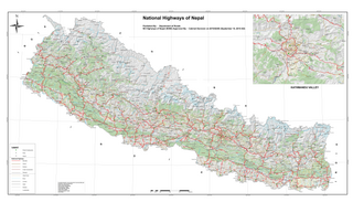
The National Highway System of Nepal is the group of main roads in Nepal. Any highway or road that connects east to west and north to south is considered a National Highway of Nepal.
India–China Border Roads is a Government of India project for developing infrastructure along the Sino-Indian border by constructing strategic roads, including bridges and tunnels. The ICBR project is largely in response to Chinese infrastructure development along the borderlands with India.

The National Highways & Infrastructure Development Corporation Limited (NHIDCL) is a fully owned company of the Government of India, set up in 2014 and is responsible for management of a network of over 10,000 km of National Highways out of 1,15,000 km in India. It is a nodal agency of the Ministry of Road Transport and Highways (MoRTH). Krishan Kumar (IAS) is the present Managing Director of NHIDCL since 14th February 2024. The corporate headquarters of NHIDCL is in Nauroji Nagar near Safdarjung Enclave, Delhi.


