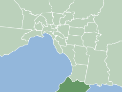
The Shire of Mornington Peninsula is a local government area in southeastern Metropolitan Melbourne, Victoria, Australia. It is located to the south of the Melbourne City Centre. It has an area of 724 square kilometres and in June 2018 it had a population of 165,822.

This is a list of local government areas (LGAs) in Victoria, sorted by region.

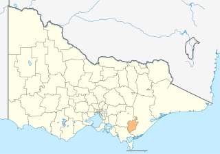
The City of Greater Geelong is a local government area in the Barwon South West region of Victoria, Australia, located in the western part of the state. It covers an area of 1,248 square kilometres (482 sq mi) and, had a population of 271,057 as of the 2021 Australian census. It is primarily urban with the vast majority of its population living in the Greater Geelong urban area, while other significant settlements within the LGA include Anakie, Balliang, Barwon Heads, Batesford, Ceres, Clifton Springs, Drysdale, Lara, Ocean Grove, Portarlington and St Leonards. It was formed in 1993 from the amalgamation of the Rural City of Bellarine, Shire of Corio, City of Geelong, City of Geelong West, City of Newtown, City of South Barwon, and parts of Shire of Barrabool and Shire of Bannockburn.

The Shire of Colac Otway is a local government area in the Barwon South West region of Victoria, Australia, located in the south-western part of the state. It covers an area of 3,438 square kilometres (1,327 sq mi) and in June 2018 had a population of 21,503. It includes the towns of Apollo Bay, Beeac, Beech Forest, Birregurra, Colac, Cressy, Forrest, Johanna, Kennett River, Lavers Hill, Warrion and Wye River. It came into existence on 23 September 1994 through the amalgamation of the local government areas of City of Colac, Shire of Colac, part of the Shire of Otway and part of the Shire of Heytesbury.
The City of Latrobe is a local government area in the Gippsland region in eastern Victoria, Australia, located in the eastern part of the state. It covers an area of 1,426 square kilometres (551 sq mi) and in June 2018 had a population of 75,211. It is primarily urban with the vast majority of its population living within the four major urban areas of Moe, Morwell, Traralgon, and Churchill, and other significant settlements in the LGA include Boolarra, Callignee, Glengarry, Jeeralang, Newborough, Toongabbie, Tyers, Yallourn North and Yinnar. It was formed in 1994 from the amalgamation of the City of Moe, City of Morwell, City of Traralgon, Shire of Traralgon, and parts of the Shire of Narracan and Shire of Rosedale. The Yallourn Works Area was added in 1996. When formed, the municipality was called the Shire of La Trobe, but on 6 April 2000, it adopted its current name.

The Shire of Alpine is a local government area in the Hume region of Victoria, Australia, located in the north-east part of the state. It covers an area of 4,788 square kilometres (1,849 sq mi) and in August 2021 had a population of 13,235.

The Town of Mosman Park is a local government area of Western Australia. It covers an area of approximately 4.3 km2 in western metropolitan Perth, the capital of Western Australia and lies about 14 km southwest of the Perth CBD and 5 km from Fremantle.
Local government is the third-level of government in Australia, administered with limited autonomy under the states and territories, and in turn beneath the federal government. Local government is not mentioned in the Constitution of Australia, and two referendums in 1974 and 1988 to alter the Constitution relating to local government were unsuccessful. Every state/territory government recognises local government in its own respective constitution. Unlike the two-tier local government system in Canada or the United States, there is only one tier of local government in each Australian state/territory, with no distinction between counties and cities.
Council rangers are officers employed by local government areas in Australia to enforce the by-laws of those local governments and a limited range of state laws relating to such matters as litter control, animal control, dog laws, cat laws, bush fire control, off-road vehicles, emergency management, and parking. A Council Ranger is also referred to as Local Laws Officers in some of Australia's eastern states.

The Shire of Northam is a local government area in the Wheatbelt region of Western Australia, beyond the northeastern fringe of the Perth metropolitan area centred on the town of Northam itself. The Shire covers an area of 1,431 square kilometres (553 sq mi). In 2007, it merged with the Town of Northam, almost tripling its population in the process from a previous size of 3,794.

The Shire of Peppermint Grove is a local government area in Perth, Western Australia, 12 kilometres (7.5 mi) southwest of the Perth central business district. At 1.1 km2 (0.42 sq mi), it is the smallest local government area in Australia; it contains only the eponymous suburb, Peppermint Grove. The council comprises seven elected councillors, with no ward divisions.
A local government area (LGA) is an administrative division of a country that a local government is responsible for. The size of an LGA varies by country but it is generally a subdivision of a state, province, division, or territory.

The Tiwi Islands Region is a local government area (LGA) of the Northern Territory, Australia. The LGA covers an area of 7,483 square kilometres (2,889 sq mi) and had an estimated population of 2,753 in June 2018, and is governed by the Tiwi Islands Regional Council, formerly Tiwi Islands Shire Council.

The City of Moreton Bay, known until July 2023 as the Moreton Bay Region, is a local government area in the north of the Brisbane metropolitan city in South East Queensland, Australia. Established in 2008, it replaced three established local government areas, the City of Redcliffe and the Shires of Pine Rivers and Caboolture.

The Gympie Region is a local government area in the Wide Bay–Burnett region of Queensland, Australia, about 170 kilometres (110 mi) north of Brisbane, the state capital. It is between the Sunshine Coast and Hervey Bay and centred on the town of Gympie. It was created in 2008 from a merger of the Shires of Cooloola and Kilkivan and part of the Shire of Tiaro.

Local government in Queensland, Australia, includes the institutions and processes by which towns and districts can manage their own affairs to the extent permitted by the Local Government Act 1993–2007. Queensland is divided into 78 local government areas, which may be called Cities, Towns, Shires, or Regions. Each area has a council that is responsible for providing a range of public services and utilities and derives its income from both rates and charges on resident ratepayers and grants and subsidies from the state and Commonwealth governments.
The Perth metropolitan region or the Perth metropolitan area is the administrative area and geographical extent of the Western Australian capital city of Perth and its conurbation.

The local government areas (LGA) of New South Wales are the third tier of government in the Australian state. Under the Local Government Act 1993 (NSW) they can manage their own affairs to the extent permitted by the legislation. They may be designated as cities or otherwise as areas, though the latter units may choose to use titles that had distinctions under older forms of the act. The smallest local government by area in the state is the Municipality of Hunter's Hill 5.7 km2 (2.2 sq mi) and the largest by area is Central Darling Shire Council 53,492 km2 (20,653 sq mi). There are 129 local government areas in the state as of December 2022.

Local government in the Australian state of Victoria consists of 79 local government areas (LGAs). Also referred to as municipalities, Victorian LGAs are classified as cities (34), shires (38), rural cities (6) and boroughs (1). In general, an urban or suburban LGA is called a city and is governed by a City Council, while a rural LGA covering a larger rural area is usually called a shire and is governed by a Shire Council. Local councils have the same administrative functions and similar political structures, regardless of their classification.