Related Research Articles
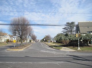
Newtown Grant is a census-designated place (CDP) in Bucks County, Pennsylvania, United States. The population was 3,620 at the 2010 census.
Buford is an unincorporated community and census-designated place (CDP) in Lancaster County, South Carolina, United States. It was first listed as a CDP in the 2020 census with a population of 398. It lies at the intersection of South Carolina Highways 9 and 522.
Homewood is an unincorporated community and census-designated place (CDP) in Horry County, South Carolina, United States, just north of Conway in the northeastern part of the state. It was first listed as a CDP in the 2020 census with a population of 1,693.
DeBordieu Colony, DeBordieu Beach or simply DeBordieu is a private, unincorporated community and census-designated place (CDP) in Georgetown County, South Carolina, United States. It consists of approximately 2,700 acres (11 km2) of land, of which roughly 800 acres is wildlife preserve inaccessible to the citizens of Georgetown County. Parts of DeBordieu lie on Debidue Island. DeBordieu is located south of Pawleys Island and north of Georgetown east of U.S. Route 17. It is an oceanfront gated community with a private golf and country club.

Sheldon is an unincorporated community and census-designated place (CDP) in Beaufort County, South Carolina, United States. It was first listed as a CDP in the 2020 census with a population of 579.
Harbor Island is a small residential island located 14 miles (22 km) east of Beaufort, South Carolina. It is one of the Carolina Sea Islands. The swing drawbridge has been replaced by a fixed high level bridge. , Harbor River Bridge, that connects the island to Saint Helena Island towards the west. A small causeway crossing Johnson Creek connects Harbor Island with Hunting Island towards the south.
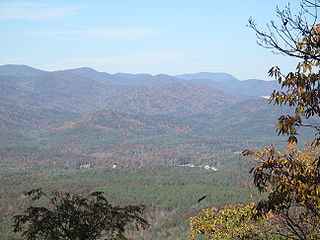
Tamassee is an unincorporated community and census-designated place (CDP) located in northwestern Oconee County, South Carolina, United States. It was first listed as a CDP in the 2020 census with a population of 60.
Dacusville is a small unincorporated community and census-designated place (CDP) in Pickens County, South Carolina, United States. It is best known for its tractor show once a year in the month of September. The community also has an elementary school and a middle school. It was first listed as a CDP in the 2020 census with a population of 399.
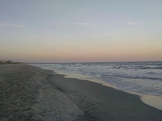
Litchfield Beach, also known simply as Litchfield, is an unincorporated community and census-designated place (CDP) in South Carolina, United States. It was first listed as a CDP in the 2020 census with a population of 8,370.
Drayton is an unincorporated community and census-designated place (CDP) in Spartanburg County, in the U.S. state of South Carolina. It was first listed as a CDP in the 2020 census with a population of 1,115.
Cash is an unincorporated community and census-designated place (CDP) in Chesterfield County, in the U.S. state of South Carolina. It was first listed as a CDP in the 2020 census with a population of 445.
Long Creek is an unincorporated community and census-designated place (CDP) in Pender County, North Carolina, United States. It was first listed as a CDP in the 2020 census with a population of 277.
Dovesville is an unincorporated community and census-designated place (CDP) in Darlington County, South Carolina, United States. It was first listed as a CDP prior to the 2020 census. Per the 2020 census, the population was 827.
Pine Ridge is an unincorporated community and census-designated place (CDP) in Darlington County, South Carolina, United States. It was first listed as a CDP prior to the 2020 census with a population of 807.
Ashwood is an unincorporated community and census-designated place (CDP) in Lee County, South Carolina, United States. It was first listed as a CDP prior to the 2020 census which showed a population of 116.
Cateechee is an unincorporated community and census-designated place (CDP) in Pickens County, South Carolina, United States. It was first listed as a CDP prior to the 2020 census. The population as of 2020 was 321.
Ben Avon is an unincorporated area and census-designated place (CDP) adjacent to the city of Spartanburg in Spartanburg County, South Carolina, United States. It was first listed as a CDP prior to the 2020 census. The population as of 2020 was 2,428.
The Cliffs Valley is a resort community and census-designated place (CDP) in Greenville County, South Carolina, United States. It was first listed as a CDP prior to the 2020 census with a population of 736.
Camp Croft is an unincorporated area and census-designated place (CDP) in Spartanburg County, South Carolina, United States. It was first listed as a CDP prior to the 2020 census. The 2020 census lists a population of 2,110.
Whitney is an unincorporated area and census-designated place (CDP) adjacent to the city of Spartanburg in Spartanburg County, South Carolina, United States. It was first listed as a CDP prior to the 2020 census with a population of 4,409.
References
- ↑ "ArcGIS REST Services Directory". United States Census Bureau. Retrieved October 15, 2022.
- 1 2 "Census Population API". United States Census Bureau. Retrieved Oct 15, 2022.
- ↑ "Long Creek ZIP Code". zipdatamaps.com. 2022. Retrieved November 11, 2022.
- ↑ U.S. Geological Survey Geographic Names Information System: Long Creek, South Carolina
- ↑ "Longcreek CDP, South Carolina". United States Census Bureau . Retrieved April 7, 2022.
- ↑ "Decennial Census of Population and Housing by Decades". US Census Bureau.
- 1 2 "P2 HISPANIC OR LATINO, AND NOT HISPANIC OR LATINO BY RACE – 2020: DEC Redistricting Data (PL 94-171) – Longcreek CDP, South Carolina". United States Census Bureau .
Municipalities and communities of Oconee County, South Carolina, United States | ||
|---|---|---|
| Cities |  | |
| Towns | ||
| CDPs | ||
| Other communities | ||
| Ghost towns | ||