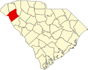
Oconee County is the westernmost county in the U.S. state of South Carolina. As of the 2020 census, the population was 78,607. Its county seat is Walhalla and its largest community is Seneca. Oconee County is included in the Seneca, SC Micropolitan Statistical Area, which is also included in the Greenville-Spartanburg-Anderson, SC Combined Statistical Area. South Carolina Highway 11, the Cherokee Foothills National Scenic Highway, begins in southern Oconee County at Interstate Highway 85 at the Georgia state line.

Anderson County is a county located in the U.S. state of South Carolina. As of the 2020 census, its population was 203,718. Its county seat is Anderson. Named for Revolutionary War leader Robert Anderson, the county is located in northwestern South Carolina, along the state line of Georgia. Anderson County is included in the Greenville-Anderson-Greer, SC Metropolitan Statistical Area. Anderson County contains 55,950-acre (22,640 ha) Lake Hartwell, a U.S. Army Corps of Engineers lake with nearly 1,000 miles (1,600 km) of shoreline for residential and recreational use. The area is a growing industrial, commercial and tourist center. It is the home of Anderson University, a private, selective comprehensive university of approximately 4,000 undergraduate and graduate students.

Johnson County is a county located along the oconee River in the U.S. state of Georgia. As of the 2020 census, the population was 9,189. The county seat is Wrightsville. Johnson County is part of the Dublin, Georgia, micropolitan statistical area.

Allentown is a city in Bleckley, Laurens, Twiggs, and Wilkinson counties in the U.S. state of Georgia, primarily in Wilkinson County. As of the 2010 census, the city had a population of 169, down from 287 at the 2000 census. In 2020, its population was 195. The Twiggs County portion is part of the Macon metropolitan statistical area, while the Laurens County portion is part of the Dublin micropolitan statistical area. The remaining Wilkinson and Bleckley County portions are not part of any metropolitan or micropolitan area.
Evans is an unincorporated community and census-designated place (CDP) in Columbia County, Georgia, United States. It is a suburb of Augusta and is part of the Augusta metropolitan area. The population was 29,011 at the 2010 census, up from 17,727 at the 2000 census.

Greensboro is a city in and the county seat of Greene County, Georgia, United States. Its population was 3,648 as of the 2020 census. The city is located approximately halfway between Atlanta and Augusta on Interstate 20.

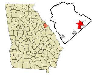
Jefferson is a city and the county seat of Jackson County, Georgia, United States. The population was 9,432 at the 2010 census, up from 3,825 at the 2000 census. As of 2019 the estimated population was 12,032.

Experiment is an unincorporated community and census-designated place (CDP) in Spalding County, Georgia, United States. The population was 3,233 at the 2000 census.

Mountain View is a census-designated place (CDP) in Catawba County, North Carolina, United States. The population was 3,552 at the 2010 census. It is part of the Hickory–Lenoir–Morganton Metropolitan Statistical Area.

Gloverville is a census-designated place (CDP) in Aiken County, South Carolina, United States. The population was 2,831 at the 2010 census. It is part of the Augusta, Georgia metropolitan area. Gloverville is located in historic Horse Creek Valley.

Joanna is an unincorporated community and census-designated place (CDP) in Laurens County, South Carolina, United States. The population was 1,539 at the 2010 census, down from 1,609 at the 2000 census. It is part of the Greenville–Mauldin–Easley Metropolitan Statistical Area.
Rougemont is an unincorporated community and census-designated place (CDP) in Durham and Person counties, North Carolina, United States. The population of the CDP was 978 at the 2010 census. An act to incorporate Rougemont as a town was introduced to the North Carolina General Assembly in 2011.
Long Creek is an unincorporated community and census-designated place (CDP) in western Oconee County, South Carolina, United States. It was first listed as a CDP in the 2020 census with a population of 96.
Darling is a census-designated place in Quitman County, Mississippi. Darling is located on Mississippi Highway 3, north of Marks. Per the 2020 Census, the population was 154.
Alcolu is an unincorporated community and census-designated place (CDP) in Clarendon County, South Carolina, United States. As of the 2010 census, its population was 429. Alcolu has a post office with ZIP code 29001, which opened on August 17, 1888. It developed as a lumber and mill town.
Smock is an unincorporated community and census-designated place that is located in Franklin and Menallen townships in Fayette County, Pennsylvania, United States. Situated roughly halfway between the borough of Perryopolis and the city of Uniontown, it is part of the Pittsburgh metropolitan area.
Godfrey is an unincorporated community and census-designated place in Morgan County, in the U.S. state of Georgia. It first appeared as a CDP in the 2020 Census with a population of 108.
Chickasaw Point is a lakeside community and census-designated place (CDP) in Oconee County, South Carolina, United States. It was first listed as a CDP prior to the 2020 census. The population as of 2020 was 718.
Keowee Key is a lakeside community and census-designated place (CDP) in Oconee County, South Carolina, United States. It is considered part of the Salem community. It was first listed as a CDP prior to the 2020 census with a population of 2,716.
South Union is an unincorporated community and census-designated place (CDP) in Oconee County, South Carolina, United States. It was first listed as a CDP prior to the 2020 census with a population of 341.