Williamston, South Carolina

Last updated

Williamston
WilliamstonSCMon.png
Top, left to right: Downtown Williamston, the grave of West Allen Williams (founder of Williamston) in Williamston Springs Mineral Park, water tower at the Williamston Mill, Williamston Municipal Center
Williamston, SC Town Flag.jpg
Williamston, SC Town Seal.jpg
SCMap-doton-Williamston.PNG
Location of Williamston, South Carolina
Coordinates: 34°37′4″N82°28′45″W / 34.61778°N 82.47917°W / 34.61778; -82.47917
CountryUnited States
State South Carolina
County Anderson
Area
[1]
  Total3.73 sq mi (9.65 km2)
  Land3.69 sq mi (9.55 km2)
  Water0.04 sq mi (0.09 km2)
Elevation
[2]
807 ft (246 m)
Population
 (2020) [3]
  Total4,043
  Density1,095.96/sq mi (423.20/km2)
Time zone UTC−5 (Eastern (EST))
  Summer (DST) UTC−4 (EDT)
ZIP code
29697
Area code 864
FIPS code 45-77875 [4]
GNIS feature ID1251452 [2]
Website www.williamstonsc.us

Williamston is a town in Anderson County, South Carolina. The population was 4,043 at the 2020 census. [5] [6]

Contents

Geography

Williamston is located in northeastern Anderson County at 34°37′4″N82°28′45″W / 34.61778°N 82.47917°W / 34.61778; -82.47917 (34.617699, -82.479256). [7] The twin towns of Pelzer and West Pelzer are 2 miles (3 km) to the north. Anderson, the county seat, is 15 miles (24 km) to the southwest.

According to the United States Census Bureau, the town has a total area of 3.7 square miles (9.5 km2), of which 3.6 square miles (9.4 km2) is land and 0.04 square miles (0.1 km2), or 1.01%, is water. [8]

Demographics

Historical population
CensusPop.Note
1890 935
1900 9916.0%
1910 1,95797.5%
1920 2,32218.7%
1930 2,235−3.7%
1940 2,50912.3%
1950 2,78210.9%
1960 3,72133.8%
1970 3,9917.3%
1980 4,3108.0%
1990 3,876−10.1%
2000 3,791−2.2%
2010 3,9343.8%
2020 4,0432.8%
2022 (est.)4,1482.6%
U.S. Decennial Census [9] [3]

2020 census

Williamston racial composition [10]
RaceNum.Perc.
White (non-Hispanic)3,11777.1%
Black or African American (non-Hispanic)51712.79%
Native American 230.57%
Asian 60.15%
Pacific Islander 10.02%
Other/Mixed 1453.59%
Hispanic or Latino 2345.79%

As of the 2020 United States census, there were 4,043 people, 1,963 households, and 1,092 families residing in the town.

2000 census

As of the census [4] of 2000, there were 3,791 people, 1,590 households, and 1,090 families residing in the town. The population density was 1,056.2 inhabitants per square mile (407.8/km2). There were 1,762 housing units at an average density of 490.9 per square mile (189.5/km2). The racial makeup of the town was 80.80% White, 17.67% African American, 0.08% Native American, 0.11% Asian, 0.66% from other races, and 0.69% from two or more races. Hispanic or Latino of any race were 1.74% of the population.

There were 1,590 households, out of which 27.6% had children under the age of 18 living with them, 49.9% were married couples living together, 14.0% had a female householder with no husband present, and 31.4% were non-families. 28.8% of all households were made up of individuals, and 14.7% had someone living alone who was 65 years of age or older. The average household size was 2.38 and the average family size was 2.91.

In the town, the population was spread out, with 22.8% under the age of 18, 7.4% from 18 to 24, 28.3% from 25 to 44, 22.7% from 45 to 64, and 18.9% who were 65 years of age or older. The median age was 40 years. For every 100 females, there were 91.7 males. For every 100 females age 18 and over, there were 86.7 males.

The median income for a household in the town was $31,458, and the median income for a family was $37,679. Males had a median income of $30,585 versus $21,771 for females. The per capita income for the town was $14,085. About 9.4% of families and 12.3% of the population were below the poverty line, including 10.3% of those under age 18 and 13.3% of those age 65 or over.

Education

Public schools in the Pelzer/Williamston/West Pelzer area are administered by Anderson District One. The public elementary schools in Anderson district one are Cedar Grove Elementary, Powdersville Elementary, Concrete Primary, Spearman Elementary, Hunt Meadows Elementary, West Pelzer Elementary, Palmetto Elementary, and Wren Elementary. The Middle schools are Palmetto Middle, Wren Middle, and Powdersville Middle. High schools are; Palmetto High School, Palmetto High Freshman Academy, Powdersville High School, Wren High School, and Wren High School Freshman Academy. [11]

Willimaston has a public library, a branch of the Anderson County Library System. [12]

Emergency Services

Related Research Articles

<span class="mw-page-title-main">Pickens County, South Carolina</span> County in South Carolina, United States

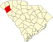
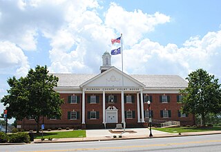
Pickens County is located in the northwest part of the U.S. state of South Carolina. As of the 2020 census, its population was 131,404. Its county seat is Pickens. The county was created in 1826. It is part of the Greenville-Anderson-Greer, SC Metropolitan Statistical Area.

<span class="mw-page-title-main">Anderson County, South Carolina</span> County in South Carolina, United States

Anderson County is a county located in the U.S. state of South Carolina. As of the 2020 census, its population was 203,718. Its county seat is Anderson. Named for Revolutionary War leader Robert Anderson, the county is located in northwestern South Carolina, along the state line of Georgia. Anderson County is included in the Greenville-Anderson-Greer, SC Metropolitan Statistical Area. Anderson County contains 55,950-acre (22,640 ha) Lake Hartwell, a U.S. Army Corps of Engineers lake with nearly 1,000 miles (1,600 km) of shoreline for residential and recreational use. The area is a growing industrial, commercial and tourist center. It is the home of Anderson University, a private, selective comprehensive university of approximately 4,000 undergraduate and graduate students.

<span class="mw-page-title-main">Union City, Georgia</span> City in Georgia, United States

Union City is a city in Fulton County, Georgia, United States. The population was 26,830 at the 2020 census.

<span class="mw-page-title-main">Lapel, Indiana</span> Town in Indiana, United States

Lapel is a town in Stony Creek and Green townships, Madison County, Indiana, United States. It is part of the Indianapolis–Carmel–Anderson metropolitan statistical area. The population was 2,325 at the 2020 census, up from 2,068 in 2010.

<span class="mw-page-title-main">Jolley, Iowa</span> City in Iowa, United States

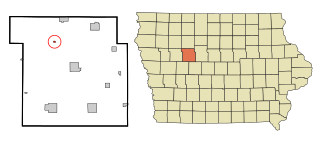
Jolley is a city in Calhoun County, Iowa, United States. The population was 28 at the time of the 2020 census.

<span class="mw-page-title-main">Williamston, Michigan</span> City in Michigan, United States

Williamston is a city in Ingham County in the U.S. state of Michigan. The population was 3,854 at the 2010 census. Williamston is located east of the city of Lansing and borders Williamstown Township to the north and Wheatfield Township to the south. The Red Cedar River and M-43 run through the center of the city.

<span class="mw-page-title-main">Waterville Valley, New Hampshire</span> Town in New Hampshire, United States

Waterville Valley is a New England town in Grafton County, New Hampshire, United States. The population was 508 at the 2020 census, up from 247 at the 2010 census.

<span class="mw-page-title-main">Williamston, North Carolina</span> Town in North Carolina, United States

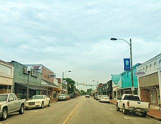
Williamston is a town and the county seat of Martin County, North Carolina, United States. The population was 5,248 at the 2020 census. It is located in North Carolina's Inner Banks region. The closest major city is Greenville, approximately 28 miles (45 km) to the southwest.

<span class="mw-page-title-main">Calhoun Falls, South Carolina</span> Town in South Carolina, United States

Calhoun Falls is a town in Abbeville County, South Carolina, United States. The population was 1,724 at the 2020 census, down from 2,004 at the 2010 census.

<span class="mw-page-title-main">Belton, South Carolina</span> City in South Carolina, United States

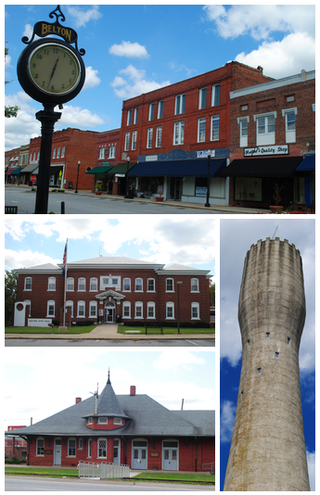
Belton is a city in eastern Anderson County, South Carolina. The population was 4,134 at the 2010 census.

<span class="mw-page-title-main">Pelzer, South Carolina</span> Town in South Carolina, United States

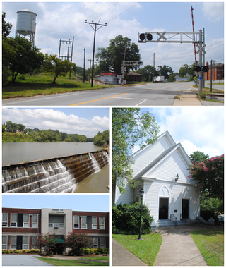
Pelzer is a town in Anderson County, South Carolina, United States, along the Saluda River. The population was 89 at the 2010 census, and grew to 1,344 at the 2020 census.

<span class="mw-page-title-main">Powdersville, South Carolina</span> CDP in South Carolina, United States

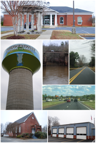
Powdersville is a census-designated place (CDP) in Anderson County, South Carolina. The population was 10,025 at the 2020 census,.

<span class="mw-page-title-main">West Pelzer, South Carolina</span> Town in South Carolina, United States

West Pelzer is a town in Anderson County, South Carolina. The population was 962 at the 2020 census.

<span class="mw-page-title-main">Mullins, South Carolina</span> City in South Carolina, United States

Mullins is a city in Marion County, South Carolina, United States. As of the 2010 census, the city population was 4,663.

<span class="mw-page-title-main">Easley, South Carolina</span> City in South Carolina, United States

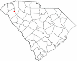
Easley is a city in Pickens County in the U.S. state of South Carolina. Most of the city lies in Pickens County, with a small portion of the city in Anderson County.

<span class="mw-page-title-main">Manvel, Texas</span> City in Texas, United States

Manvel is a city in Brazoria County, Texas, United States. As of July 2022, the population was 14,803, up from 9,908 at the 2020 census.

<span class="mw-page-title-main">Nesbitt, Texas</span> Unincorporated community in Texas, United States

Nesbitt is an unincorporated community in Harrison County, Texas, United States. Nesbitt's town government was disestablished on January 1, 2000, but it was still listed as a town at the 2010 census, with a population of 281.

<span class="mw-page-title-main">Piedmont, South Carolina</span> CDP in South Carolina, United States

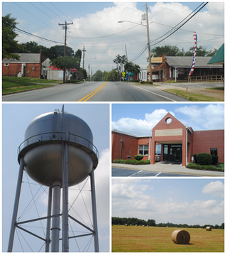
Piedmont is a census-designated place (CDP) along the Saluda River in Anderson and Greenville counties in the U.S. state of South Carolina. The population was 5,411 at the 2020 census.

<span class="mw-page-title-main">Kennedy Township, Allegheny County, Pennsylvania</span> Township in Pennsylvania, United States

Kennedy Township is a township in Allegheny County, Pennsylvania, United States, located 10 miles west of Pittsburgh and 12 miles east of Pittsburgh International Airport. The population was 8,701 at the 2020 United States Census.

<span class="mw-page-title-main">Oregon, Wisconsin</span> Village in Wisconsin, United States

Oregon is a village in Dane County, Wisconsin. As of the census of 2020, the population was 11,179. Oregon is part of the Madison Metropolitan Statistical Area. The village is located mostly within the Town of Oregon.

References

  1. "ArcGIS REST Services Directory". United States Census Bureau. Retrieved October 15, 2022.
  2. 1 2 U.S. Geological Survey Geographic Names Information System: Williamston, South Carolina
  3. 1 2 "Census Population API". United States Census Bureau. Retrieved October 15, 2022.
  4. 1 2 "U.S. Census website". United States Census Bureau . Retrieved January 31, 2008.
  5. "Population and Housing Unit Estimates". United States Census Bureau. 2016.
  6. "Population and Housing Unit Estimates". United States Census Bureau. Retrieved November 18, 2017.
  7. "US Gazetteer files: 2010, 2000, and 1990". United States Census Bureau. February 12, 2011. Retrieved April 23, 2011.
  8. "Geographic Identifiers: 2010 Demographic Profile Data (G001): Williamston town, South Carolina". U.S. Census Bureau, American Factfinder. Archived from the original on February 12, 2020. Retrieved August 8, 2013.
  9. "Census of Population and Housing". Census.gov. Retrieved June 4, 2015.
  10. "Explore Census Data". data.census.gov. Retrieved December 14, 2021.
  11. "Schools / Primary & Elementary Schools". Anderson1.k12.sc.us. Retrieved January 2, 2018.
  12. "South Carolina libraries and archives". SCIWAY. Retrieved June 7, 2019.