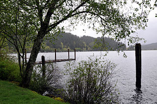
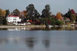
Detroit Lake is a reservoir impounded by the Detroit Dam on the North Santiam River 46 miles (74 km) southeast of Salem, Oregon, United States. The lake is adjacent to Oregon Route 22 near the city of Detroit. This mesotrophic lake stores water for use by the city of Salem and other nearby communities.
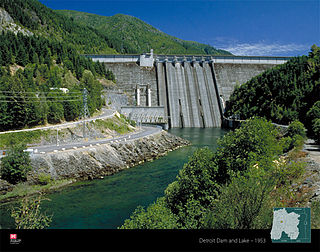
Detroit Dam is a gravity dam on the North Santiam River between Linn County and Marion County, Oregon. It is located in the Cascades, about 5 mi (8.0 km) west of the city of Detroit. It was constructed between 1949 and 1953 by the United States Army Corps of Engineers. The dam created 400-foot (120 m) deep Detroit Lake, more than 9 miles (14 km) long with 32 miles (51 km) of shoreline.

Mount McLoughlin is a steep-sided stratovolcano, or composite volcano, in the Cascade Range of southern Oregon and within the Sky Lakes Wilderness. It is one of the volcanic peaks in the Cascade Volcanic Arc, within the High Cascades sector. A prominent landmark for the Rogue River Valley, the mountain is north of Mount Shasta, and Crater Lake lies to the north-northeast. It was named around 1838 after John McLoughlin, a Chief Factor for the Hudson's Bay Company. McLouglin's prominence has made it a landmark to Native American populations for thousands of years.

The North Yamhill River is a 31-mile (50 km) tributary of the Yamhill River in the U.S. state of Oregon. It drains an area of the Northern Oregon Coast Range, as well as part of the Willamette Valley west of the Willamette River.

The Bull Run River is a 21.9-mile (35.2 km) tributary of the Sandy River in the U.S. state of Oregon. Beginning at the lower end of Bull Run Lake in the Cascade Range, it flows generally west through the Bull Run Watershed Management Unit (BRWMU), a restricted area meant to protect the river and its tributaries from contamination. The river, impounded by two artificial storage reservoirs as well as the lake, is the primary source of drinking water for the city of Portland, Oregon.

Black Butte is a stratovolcano 5.5 miles (8.9 km) west of Sisters, Oregon in Deschutes National Forest.

Loon Lake Reservoir is a reservoir in the Eldorado National Forest of El Dorado County, California, United States. The 76,200 acre⋅ft (94,000,000 m3) lake is formed by Loon Lake Dam, completed in 1963 as part of the Upper American River Project by Sacramento Municipal Utility District to conserve spring snow melt runoff for use during the summer and autumn for hydroelectric power production. Loon Lake Dam impounds water at the headwaters of Gerle Creek which, prior to the dam, flowed intermittently through (natural) Loon and Pleasant Lakes. But most of the water now stored in Loon Lake Reservoir arrives from Buck Island Reservoir in the adjacent Rubicon River watershed by way of the Buck-Loon Tunnel. Nearby is Loon Lake Chalet, a popular winter recreation destination. In summer, a boat ramp for water sports and camping are available, but the area is less popular than nearby Union Valley Reservoir and Rubicon Trail.
The Donner und Blitzen River is a river on the eastern Oregon high desert which drains a relatively arid basin, the southern portion of Harney Basin, from roughly 20 to 80 miles south-southeast of Burns including Malheur National Wildlife Refuge. Though much of its course is marsh, it offers scenic glaciated canyons, unique ecosystems, and exceptional wild trout fisheries. Named by soldiers of German origin, the Donner und Blitzen River translates as "thunder and lightning". The name usually brings to mind two of Santa Claus' reindeer, but the river is named for a thunderstorm the soldiers experienced as they crossed the river; dry lightning is an almost daily occurrence in the region during certain times of the year.

Olallie Butte is a steep-sided shield volcano in the Cascade Range of the northern part of the U.S. state of Oregon. It is the largest volcano and highest point in the 50-mile (80 km) distance between Mount Hood and Mount Jefferson. Located just outside the Olallie Scenic Area, it is surrounded by more than 200 lakes and ponds fed by runoff, precipitation, and underground seepage, which are popular spots for fishing, boating, and swimming. The butte forms a prominent feature in the Mount Jefferson region and is usually covered with snow during the winter and spring seasons.

Little Yosemite Valley is a smaller glacial valley upstream in the Merced River drainage from the Yosemite Valley in Yosemite National Park. The Merced River meanders through the 3.5 mi (5.6 km) long flat valley, draining out over Nevada Fall and Vernal Fall before emptying into the main Yosemite Valley. It can be reached by a day hike from the main valley, and is the most popular area in the Yosemite Wilderness. The Valley provides access to nearby destinations such as the back side of Half Dome, Clouds Rest and the High Sierra Camp at Merced Lake.
Triangle Lake is an unincorporated community in Lane County, Oregon, United States. It is about 25 miles (40 km) west of Junction City on Oregon Route 36, on the southwest side of the lake of same name. Lake Creek, a tributary of the Siuslaw River, enters and exits the lake. Triangle Lake is closely linked to the unincorporated community of Blachly, on the northeast side of the lake, and the two communities share the K-12 Triangle Lake School, the only school in Blachly School District. Triangle Lake is served by the Blachly post office and the Pioneer Telephone Cooperative.

Butte Creek is a stream in the U.S. state of Oregon, a tributary of the Pudding River. It is approximately 33 miles (53 km) long and, for all of its course, defines part of the northeastern boundary of Marion County and the southern boundary of Clackamas County.

Eagle Cap Wilderness is a wilderness area located in the Wallowa Mountains of northeastern Oregon, within the Wallowa–Whitman National Forest. The wilderness was established in 1940. In 1964, it was included in the National Wilderness Preservation System. A boundary revision in 1972 added 73,000 acres (30,000 ha) and the Wilderness Act of 1984 added 66,100 acres (26,700 ha) resulting in a current total of 361,446 acres, making Eagle Cap by far Oregon's largest wilderness area.

The Cascades ecoregion is a Level III ecoregion designated by the United States Environmental Protection Agency (EPA) in the U.S. states of Washington, Oregon, and California. Somewhat smaller than the Cascade mountain range for which it is named, the ecoregion extends north to Snoqualmie Pass, near Seattle, and south to Hayden Pass, near the Oregon-California border, including the peaks and western slopes of most of the High Cascades. A discontiguous section is located on Mount Shasta in California.

Lake Sunapee is located within Sullivan County and Merrimack County in western New Hampshire, the United States. It is the fifth-largest lake located entirely in New Hampshire.
Fairview Creek is a 5-mile (8.0 km) tributary of the Columbia Slough in the U.S. state of Oregon. The creek forms in a wetland near Grant Butte in Gresham and flows north for 5 miles (8.0 km) to Fairview Lake in Fairview. Grant Butte, rising to 602 feet (183 m) above sea level, is one of eight dormant volcanic formations near Gresham. Fairview Creek begins northeast of the butte at an elevation of 278 feet (85 m) and falls to an elevation of 10 feet (3.0 m) at the lake.

Salt Creek Falls is a cascade and plunge waterfall on Salt Creek, a tributary of the Middle Fork Willamette River, that plunges into a gaping canyon near Willamette Pass in the Willamette National Forest, near Oakridge, Oregon. The waterfall is notable for its main drop of 286 feet (87 m) which makes it the third highest plunge waterfall in Oregon after Multnomah Falls and Watson Falls the second highest, which was re-measured in 2009 and found to be 293 feet rather than an earlier measurement of 272 feet passing Salt Creek Falls. The pool at the bottom of the waterfall is 20 metres (66 ft) deep.

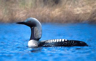
Loon Lake is a 1,100-acre (450 ha) lake located in Stevens County, Washington, 30 miles (48 km) north-northwest of Spokane, Washington at an elevation of 726 metres (2,382 ft). The lake is about two miles wide, one mile long, and has a maximum depth of 100 feet (30 m).

The South Fork Breitenbush River is a 10-mile (16 km) tributary of the Breitenbush River in the U.S. state of Oregon. The river flows generally northwest from Russell Lake in the Mount Jefferson Wilderness of the Cascade Range to near Breitenbush Hot Springs, where it merges with the North Fork Breitenbush River to form the main stem.

Floras Lake is a natural 236-acre (96 ha) body of water on the southern Oregon Coast of the United States. Fed by four small tributaries from a basin of about 10 square miles (26 km2) in Curry County, it lies about 10 miles (16 km) north of Port Orford and 2 miles (3 km) west of U.S. Route 101. It was probably named for Fred Flora, a 19th-century settler and miner who lived nearby.