Douglas County, Oregon

Last updated

Douglas County
Douglas County Courthouse Oregon (cropped).jpg
Douglas County Courthouse in Roseburg
Map of Oregon highlighting Douglas County.svg
Location within the U.S. state of Oregon
Oregon in United States.svg
Oregon's location within the U.S.
Coordinates: 43°17′N123°11′W / 43.29°N 123.18°W / 43.29; -123.18
CountryFlag of the United States.svg United States
StateFlag of Oregon.svg  Oregon
FoundedJanuary 7, 1852
Named for Stephen A. Douglas
Seat Roseburg
Largest cityRoseburg
Area
  Total5,134 sq mi (13,300 km2)
  Land5,036 sq mi (13,040 km2)
  Water98 sq mi (250 km2)  1.9%
Population
 (2020)
  Total111,201
  Estimate 
(2023)
112,435 Increase2.svg
  Density21/sq mi (8/km2)
Time zone UTC−8 (Pacific)
  Summer (DST) UTC−7 (PDT)
Congressional districts 2nd, 4th
Website douglascountyor.gov
Map of Douglas County Douglas County.svg
Map of Douglas County
The county, looking east from west of Roseburg Douglas County, OR from Callahans.JPG
The county, looking east from west of Roseburg
A gold "needle" from the Bohemia District in Douglas County Gold-md63a.jpg
A gold "needle" from the Bohemia District in Douglas County

Douglas County is one of the 36 counties in the U.S. state of Oregon. As of the 2020 census, the population was 111,201. [1] The county seat is Roseburg. [2] The county is named after Stephen A. Douglas, an American politician who supported Oregon statehood. Douglas County comprises the Roseburg, OR Micropolitan Statistical Area. In regards to area, Douglas County is the largest county west of the Oregon Cascades.

Contents

History

The area originally was inhabited by the Umpqua Indians, a grouping of natives who spoke a variety of Penutian and Athabaskan languages. Following the Rogue River Indian War in 1856, most of the remaining natives were moved by the government to the Grand Ronde Indian Reservation. However, seven families of Umpqua hid in the hills, eluding capture for many decades. They are now federally recognized as the Cow Creek Band of Umpqua Tribe of Indians. The tribe manages a small reservation in Canyonville, Oregon, and has a Casino/Hotel named Seven Feathers to represent the seven families who refused forced removal to the Grand Ronde Reservation.

Douglas County was created on January 7, 1852, from the portion of Umpqua County which lay east of the Coast Range summit. In 1856 the Camas Valley was annexed to Douglas County from Coos County. In 1862, the rest of Umpqua county was absorbed into Douglas County, some say due to the loss of population following the end of the early gold boom, while others attribute the absorption to politics. Further boundary adjustments were made with Jackson and Lane Counties in 1915. The borders of Douglas County are largely defined by the Umpqua River watershed.

In 2017, after the defeat of a referendum, the Douglas County Library System ceased operations and all public libraries in the county were closed. [3] Subsequently, 10 of the cities reopened their libraries to continue serving their communities.

Geography

According to the United States Census Bureau, the county has a total area of 5,134 square miles (13,300 km2), of which 5,036 square miles (13,040 km2) is land and 98 square miles (250 km2) (1.9%) is water. [4] It is the fifth-largest county in Oregon by area. A portion of the Umpqua National Forest is in Douglas County. Douglas County is one of two Oregon counties that extend from the Pacific Ocean to the Cascade Range. (The other is Lane County.)

National protected areas

Adjacent counties

Demographics

An aerial view of the county Douglas County, OR aerial.JPG
An aerial view of the county
Historical population
CensusPop.Note
1860 3,203
1870 6,06689.4%
1880 9,59658.2%
1890 11,86423.6%
1900 14,56522.8%
1910 19,67435.1%
1920 21,3328.4%
1930 21,9653.0%
1940 25,72817.1%
1950 54,549112.0%
1960 68,45825.5%
1970 71,7434.8%
1980 93,74830.7%
1990 94,6491.0%
2000 100,3996.1%
2010 107,6677.2%
2020 111,2013.3%
2023 (est.)112,435 [5] 1.1%
U.S. Decennial Census [6]
1790–1960 [7] 1900–1990 [8]
1990–2000 [9] 2010–2020 [1]

2020 census

As of the 2020 census, there were 111,201 people residing in the county. [1]

2010 census

As of the 2010 census, there were 107,667 people, 44,581 households, and 29,839 families living in the county. [10] The population density was 21.4 inhabitants per square mile (8.3 inhabitants/km2). There were 48,915 housing units at an average density of 9.7 units per square mile (3.7 units/km2). [11] The racial makeup of the county was 92.4% white, 1.8% American Indian, 1.0% Asian, 0.3% black or African American, 0.1% Pacific islander, 1.2% from other races, and 3.2% from two or more races. Those of Hispanic or Latino origin made up 4.7% of the population. [10] In terms of ancestry, 25.6% were German, 16.7% were Irish, 15.8% were English, and 5.7% were American. [12]

Of the 44,581 households, 26.4% had children under the age of 18 living with them, 51.2% were married couples living together, 10.8% had a female householder with no husband present, 33.1% were non-families, and 26.6% of all households were made up of individuals. The average household size was 2.38 and the average family size was 2.82. The median age was 46.1 years. [10]

The median income for a household in the county was $39,711 and the median income for a family was $48,729. Males had a median income of $39,308 versus $28,176 for females. The per capita income for the county was $21,342. About 10.6% of families and 15.6% of the population were below the poverty line, including 24.1% of those under age 18 and 9.0% of those age 65 or over. [13]

2000 census

As of the 2000 census, there were 100,399 people, 39,821 households, and 28,233 families living in the county. The population density was 20 people per square mile (7.7 people/km2). There were 43,284 housing units at an average density of 9 units per square mile (3.5/km2). The racial makeup of the county was 93.86% White, 0.18% Black or African American, 1.52% Native American, 0.63% Asian, 0.09% Pacific Islander, 1.02% from other races, and 2.70% from two or more races. 3.27% of the population were Hispanic or Latino of any race. 18.4% were of German, 13.2% American, 12.6% English and 10.2% Irish ancestry. 96.5% spoke English and 2.2% Spanish as their first language.

There were 39,821 households, out of which 29.10% had children under the age of 18 living with them, 57.2% were married couples living together, 9.6% had a female householder with no husband present, and 29.1% were non-families. 23.9% of all households were made up of individuals, and 11% had someone living alone who was 65 years of age or older. The average household size was 2.48 and the average family size was 2.9.

In the county, the population was spread out, with 24% under the age of 18, 7.5% from 18 to 24, 24.2% from 25 to 44, 26.4% from 45 to 64, and 17.8% who were 65 years of age or older. The median age was 41 years. For every 100 females there were 96.8 males. For every 100 females age 18 and over, there were 94.2 males.

The median income for a household in the county was $33,223, and the median income for a family was $39,364. Males had a median income of $32,512 versus $22,349 for females. The per capita income for the county was $16,581. About 9.6% of families and 13.1% of the population were below the poverty line, including 16.6% of those under age 18 and 9.2% of those age 65 or over.

Communities

Cities

Census-designated places

Unincorporated communities

Transportation

Roads

Oregon Route 99 runs through Azalea, Tri-City, Myrtle Creek, Canyonville, Green, Roseburg, Winchester, Sutherlin, Rice Hill, Drain, and Anlauf.

Interstate 5 provides access to the communities of Tri-City, Myrtle Creek, Canyonville, Green, Roseburg, Sutherlin, and Rice Hill.

Oregon Route 138 runs northwest from Roseburg to Elkton, Oregon, and generally east from Roseburg to its terminus at a junction with U.S. Route 97, just east of Diamond Lake and Crater Lake.

Buses

The communities of Douglas county are regionally served by U-Trans (formerly Umpqua Transit), the local bus service. In 2017, these services were significantly expanded to include locations such as Oakland, Oregon and Tenmile

Greyhound Lines provide the community of Roseburg with more distant transportation.

Airports

There are two public airports in Roseburg, Marion E. Carl Memorial Field at the north end of town and George Felt Airport to the west.

Politics

In contrast to the Willamette Valley, Douglas County is powerfully conservative and Republican, being akin to Josephine County to the south, or to Eastern Oregon. No Democratic presidential nominee has carried Douglas County since Lyndon Johnson's landslide win in 1964: indeed the last Democrat to crack forty percent of the county's vote was Michael Dukakis in 1988 during an election influenced by a major drought. Historically, the county, like all of Western Oregon north of the Rogue Valley, also leaned strongly Republican: before 1964 the only other Democrats to carry Douglas County had been John F. Kennedy in 1960, Franklin Delano Roosevelt in 1936 and 1932, Woodrow Wilson in 1912 and William Jennings Bryan in 1896. [14]

Douglas County is split between the heavily Republican 2nd congressional district, represented by Cliff Bentz, and the liberal-leaning 4th district, which includes the liberal stronghold of Eugene and has been represented by Democrat Val Hoyle since 2023. Within the Oregon House of Representatives, Douglas County is split between four districts. The coastal part, including Reedsport, lies within the 9th District represented by Republican Boomer Wright. A belt from Roseburg south lies in the 4th District, which extends into Jackson and Josephine counties, is represented by Republican Christine Goodwin. The far southwest adjacent to Curry and Coos counties is within the 1st District represented by Republican David Brock Smith, and the bulk of the county, centered on the northeastern half, lies in the 2nd District represented by Republican Virgle Osborne.

In the Oregon State Senate, Douglas County is split between three districts. The coastal part (9th House of Representatives District) lies within the 5th Senate District represented by Republican Dick Anderson. The two southwestern State House Districts (1st and 2nd) are part of the 1st Senate District represented by Republican David Brock Smith. The southernmost portion of Douglas County exists within the state's 2nd Senate District, represented by Republican Art Robinson.

Despite its conservative reputation, Douglas County voters rejected a secessionist proposal to join the Greater Idaho coalition in May of 2022.

United States presidential election results for Douglas County, Oregon [15] [16]
Year Republican Democratic Third party
No.%No.%No.%
2020 43,29867.29%19,16029.78%1,8912.94%
2016 34,58264.61%14,09626.34%4,8439.05%
2012 30,77661.80%17,14534.43%1,8823.78%
2008 30,91958.41%20,29838.34%1,7203.25%
2004 35,95665.39%18,08932.90%9391.71%
2000 30,29464.16%14,19330.06%2,7335.79%
1996 21,85551.10%15,25035.66%5,66413.24%
1992 19,01141.45%14,13730.83%12,71227.72%
1988 20,12052.38%17,25544.92%1,0402.71%
1984 25,24363.11%14,60936.53%1440.36%
1980 23,10158.46%12,56431.79%3,8519.75%
1976 16,50050.04%14,96545.39%1,5084.57%
1972 15,88157.73%9,00932.75%2,6189.52%
1968 13,41051.40%9,18635.21%3,49613.40%
1964 9,80638.13%15,90961.86%20.01%
1960 12,49348.39%13,32251.61%00.00%
1956 13,83753.92%11,82546.08%00.00%
1952 14,10964.11%7,83735.61%630.29%
1948 7,67156.35%5,50040.41%4413.24%
1944 6,13456.59%4,56342.09%1431.32%
1940 5,99155.63%4,70743.70%720.67%
1936 4,25442.08%4,89348.40%9639.53%
1932 4,04644.69%4,63851.23%3704.09%
1928 5,60970.52%2,19127.55%1541.94%
1924 4,21953.75%1,66621.23%1,96425.02%
1920 4,40260.18%2,42833.19%4856.63%
1916 3,92248.16%3,67945.18%5426.66%
1912 1,26726.04%1,60132.90%1,99841.06%
1908 2,09253.81%1,35934.95%43711.24%
1904 2,44363.21%90823.49%51413.30%
1900 1,91051.94%1,62444.17%1433.89%
1896 1,91747.66%2,05951.19%461.14%
1892 1,32944.27%52917.62%1,14438.11%
1888 1,30551.72%1,11744.27%1014.00%
1884 1,21651.20%1,12547.37%341.43%
1880 1,25652.80%1,10546.45%180.76%

Economy

Almost the entire watershed of the Umpqua River lies within the boundaries of Douglas County. The heavily timbered county contains nearly 1.8 million acres (7,300 km2) of commercial forest lands and one of the oldest stands of old growth timber in the world. Approximately 25–30% of the labor force is employed in the forest products industry. Agriculture, mainly field crops, orchards, and livestock (particularly sheep ranching), is also important to the economy of the county. The land of Douglas County is roughly half-publicly and half-privately owned. [17]

The post-Prohibition wine industry in Oregon began with Richard Somer planting Hillcrest Vineyard at the south end of the Umpqua Valley in 1961. The Umpqua Valley wine appellation lies entirely within Douglas county.

Nickel has been refined at Riddle since 1954. There is a significant federal presence in the region; the Forest Service and Bureau of Land Management administer more than 50% of the county's land.

As of 2015, the top ten private employers in the county were: [18]

#Employer# of Employees
1 Roseburg Forest Products 1,885
2 Mercy Medical Center 1,092
3 Swanson Group Aviation 682
4TMS Call Center615
5 Seven Feathers Hotel & Casino Resort 606
6First Call Resolution424
7 Umpqua Bank 331
8Orenco Systems266
9A&M Transport, Inc.200
10Douglas County Forest Products160

Media

See also

Notes

    Related Research Articles

    <span class="mw-page-title-main">Union County, Oregon</span> County in Oregon, United States

    Union County is one of the 36 counties in the U.S. state of Oregon, and one of the 8 counties of eastern Oregon. As of the 2020 census, the population was 26,196. The county comprises the La Grande micropolitan statistical area and the county seat is La Grande.

    <span class="mw-page-title-main">Polk County, Oregon</span> County in Oregon, United States

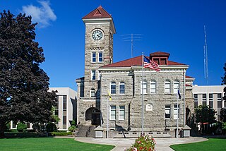
    Polk County is one of the 36 counties in the U.S. state of Oregon. As of the 2020 census, the population was 87,433. The county seat is Dallas. The county is named for James Knox Polk, the 11th president of the United States.

    <span class="mw-page-title-main">Malheur County, Oregon</span> County in Oregon, United States

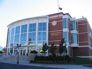
    Malheur County is one of the 36 counties in the U.S. state of Oregon. As of the 2020 census, the population was 31,571. Its county seat is Vale, and its largest city is Ontario. The county was named after the Malheur River, which runs through the county. The word "malheur" is French for misfortune or tragedy. Malheur County is included in the Ontario, Oregon Micropolitan Statistical Area, which is also included in the Boise Combined Statistical Area. It is included in the eight-county definition of Eastern Oregon.

    <span class="mw-page-title-main">Lane County, Oregon</span> County in Oregon, United States

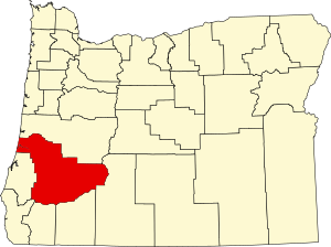
    Lane County is one of the 36 counties in the U.S. state of Oregon. As of the 2020 census, the population was 382,971, making it the fourth-most populous county in Oregon. The county seat is Eugene, the state's second most populous city. It is named in honor of Joseph Lane, Oregon's first territorial governor.

    <span class="mw-page-title-main">Klamath County, Oregon</span> County in Oregon, United States

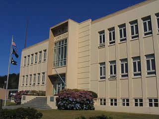
    Klamath County is one of the 36 counties in the U.S. state of Oregon. As of the 2020 census, the population was 69,413. The county seat is Klamath Falls. The county was named for the Klamath, the tribe of Native Americans living in the area at the time the first European explorers entered the region. Klamath County comprises the Klamath Falls, OR Micropolitan Statistical Area.

    <span class="mw-page-title-main">Josephine County, Oregon</span> County in Oregon, United States

    Josephine County is one of the 36 counties in the U.S. state of Oregon. As of the 2020 census, the population was 88,090. The county seat is Grants Pass. The county is named after Virginia Josephine Rollins (1834-1912), a settler who was the first white woman to live in the county's boundaries. Josephine County comprises the Grants Pass, OR Metropolitan Statistical Area, which is included in the Medford-Grants Pass, OR Combined Statistical Area.

    <span class="mw-page-title-main">Jackson County, Oregon</span> County in Oregon, United States

    Jackson County is one of the 36 counties in the U.S. state of Oregon. As of the 2020 census, the population was 223,259. The county seat is Medford. The county is named for Andrew Jackson, the seventh president of the United States.

    <span class="mw-page-title-main">Curry County, Oregon</span> County in Oregon, United States

    Curry County is the southwesternmost county in the U.S. state of Oregon located on the South Coast. As of the 2020 census, the population was 23,446. The county seat is Gold Beach. The county is named for George Law Curry, a two-time governor of the Oregon Territory. Curry County includes the Brookings, OR Micropolitan Statistical Area.

    <span class="mw-page-title-main">Coos County, Oregon</span> County in Oregon, United States

    Coos County is one of the 36 counties in the U.S. state of Oregon. As of the 2020 census, the population was 64,929. The county seat is Coquille. The county was formed from the western parts of Umpqua and Jackson counties. It is named after a tribe of Native Americans who live in the region. Coos County comprises the Coos Bay, OR Micropolitan Statistical Area.

    <span class="mw-page-title-main">Benton County, Oregon</span> County in Oregon, United States

    Benton County is one of the 36 counties in the U.S. state of Oregon. As of the 2020 census, the population was 95,184. Its county seat is Corvallis. The county was named after Thomas Hart Benton, a U.S. Senator who advocated American control over the Oregon Country. Benton County is designated as the Corvallis, OR Metropolitan Statistical Area, which is included in the Portland–Vancouver–Salem, OR–WA Combined Statistical Area. It is in the Willamette Valley.

    <span class="mw-page-title-main">Canyonville, Oregon</span> City in Oregon, United States

    Canyonville is a city in Douglas County, Oregon, United States. The population was 1,884 at the 2010 census. The main regional tourist attraction, the Seven Feathers Casino Resort is in Canyonville. The Weaver-Worthington Farmstead, a National Historical Landmark, is located near Canyonville.

    <span class="mw-page-title-main">Myrtle Creek, Oregon</span> City in Oregon, United States

    Myrtle Creek is a city in Douglas County, Oregon, United States. The population was 3,439 at the 2010 census.

    <span class="mw-page-title-main">Reedsport, Oregon</span> City in Oregon, United States

    Reedsport is a city in northwest Douglas County, Oregon, United States. As of the 2020 census, the population was 4,310.

    <span class="mw-page-title-main">Riddle, Oregon</span> City in Oregon, United States

    Riddle is a city in Douglas County, Oregon, United States. The population was 1,185 at the 2010 census.

    <span class="mw-page-title-main">Roseburg, Oregon</span> City in Oregon, United States

    Roseburg is a city in the U.S. state of Oregon. It is in the Umpqua River Valley in southern Oregon and is the county seat and most populous city of Douglas County. Founded in 1851, the population was 23,683 at the 2020 census, making it the principal city of the Roseburg, Oregon Micropolitan Statistical Area. The community developed along both sides of the South Umpqua River and is traversed by Interstate 5. Traditionally a lumber industry town, Roseburg was the original home of Roseburg Forest Products, which is now based in nearby Springfield.

    <span class="mw-page-title-main">Roseburg North, Oregon</span> CDP in Oregon, United States

    Roseburg North is a census-designated place (CDP) in Douglas County, Oregon, United States. The population was 5,912 at the 2010 census. Winchester, Oregon is included as part of Roseburg North.

    <span class="mw-page-title-main">Tri-City, Oregon</span> Unincorporated community in the state of Oregon, United States

    Tri-City is a census-designated place (CDP) and unincorporated community in Douglas County, Oregon, United States. The population was 3,931 at the 2010 census. The community in Missouri Bottom near the Umpqua River is named for the three cities among which it is centered: Myrtle Creek, Canyonville and Riddle. The Tri City School District probably originated the name, which was later adopted by the local sewer district and the former Tri City State Airport.

    <span class="mw-page-title-main">Winchester Bay, Oregon</span> Unincorporated community in the state of Oregon, United States

    Winchester Bay, formerly Umpqua City, is an unincorporated community in Douglas County, Oregon, United States. For statistical purposes, the United States Census Bureau has defined Winchester Bay as a census-designated place (CDP). The census definition of the area may not precisely correspond to local understanding of the area with the same name. The population of the CDP was 382 at the 2010 census. The community of Umpqua City was established in 1850.

    <span class="mw-page-title-main">Winston, Oregon</span> City in Oregon, United States

    Winston is a city in Douglas County, Oregon, United States, located 7 miles southwest of Roseburg. The population was 5,379 according to the 2010 United States Census. Winston is probably best-known as the home of Wildlife Safari.

    <span class="mw-page-title-main">Sutherlin, Oregon</span> City in Oregon, United States

    Sutherlin is a city in Douglas County, Oregon, United States. As of the 2010 Census, the population was 7,810, making it the second most populous city in Douglas County. Located off of I-5, nearby features include Cooper Creek Reservoir, Ford's pond, the Umpqua River, a golf course, and numerous vineyards.

    References

    1. 1 2 3 "State & County QuickFacts". United States Census Bureau. Retrieved May 15, 2023.
    2. "Find a County". National Association of Counties. Archived from the original on May 31, 2011. Retrieved June 7, 2011.
    3. "Anti-Tax Fervor Closed Their Libraries. Now Residents Are Trying to Go It Alone". MSN . Retrieved October 20, 2018.
    4. "2010 Census Gazetteer Files". United States Census Bureau. August 22, 2012. Retrieved February 25, 2015.
    5. "Annual Estimates of the Resident Population for Counties: April 1, 2020 to July 1, 2023". United States Census Bureau. Retrieved March 24, 2024.
    6. "U.S. Decennial Census". United States Census Bureau. Retrieved February 25, 2015.
    7. "Historical Census Browser". University of Virginia Library. Retrieved February 25, 2015.
    8. Forstall, Richard L., ed. (March 27, 1995). "Population of Counties by Decennial Census: 1900 to 1990". United States Census Bureau. Retrieved February 25, 2015.
    9. "Census 2000 PHC-T-4. Ranking Tables for Counties: 1990 and 2000" (PDF). United States Census Bureau. April 2, 2001. Archived from the original (PDF) on February 26, 2015. Retrieved February 25, 2015.
    10. 1 2 3 "DP-1 Profile of General Population and Housing Characteristics: 2010 Demographic Profile Data". United States Census Bureau. Archived from the original on February 13, 2020. Retrieved February 23, 2016.
    11. "Population, Housing Units, Area, and Density: 2010 - County". United States Census Bureau. Archived from the original on February 13, 2020. Retrieved February 23, 2016.
    12. "DP02 SELECTED SOCIAL CHARACTERISTICS IN THE UNITED STATES – 2006-2010 American Community Survey 5-Year Estimates". United States Census Bureau. Archived from the original on February 13, 2020. Retrieved February 23, 2016.
    13. "DP03 SELECTED ECONOMIC CHARACTERISTICS – 2006-2010 American Community Survey 5-Year Estimates". United States Census Bureau. Archived from the original on February 13, 2020. Retrieved February 23, 2016.
    14. Menendez, Albert J.; The Geography of Presidential Elections in the United States, 1868-2004, pp. 284-286 ISBN   0786422173
    15. Leip, David. "Dave Leip's Atlas of U.S. Presidential Elections". uselectionatlas.org. Retrieved April 2, 2018.
    16. "Our Campaigns - U.S. President" . Retrieved January 22, 2021.
    17. "Douglas County Case Study". Darkwing.uoregon.edu. Retrieved June 16, 2013.
    18. "2015 Douglas County Largest Employers (private sector)" (PDF). Umpqua Economic Development Partnership. Archived from the original (PDF) on October 1, 2015. Retrieved March 11, 2015.

    Further reading

    43°17′N123°11′W / 43.29°N 123.18°W / 43.29; -123.18