Hood River County, Oregon

Last updated

Hood River County
Hood River County Courthouse.jpg
Hood River County Courthouse in Hood River
Map of Oregon highlighting Hood River County.svg
Location within the U.S. state of Oregon
Oregon in United States.svg
Oregon's location within the U.S.
Coordinates: 45°31′03″N121°38′58″W / 45.5175°N 121.64944444444°W / 45.5175; -121.64944444444
CountryFlag of the United States.svg United States
StateFlag of Oregon.svg  Oregon
FoundedJune 23, 1908
Named for Hood River
Seat Hood River
Largest cityHood River
Area
  Total533 sq mi (1,380 km2)
  Land522 sq mi (1,350 km2)
  Water11 sq mi (30 km2)  2.1%
Population
 (2020)
  Total23,977
  Estimate 
(2022)
23,745 Decrease2.svg
  Density43/sq mi (17/km2)
Time zone UTC−8 (Pacific)
  Summer (DST) UTC−7 (PDT)
Congressional district 3rd
Website hoodrivercounty.gov

Hood River County is one of the 36 counties in the U.S. state of Oregon. As of the 2020 census, the population was 23,977. [1] The county seat is Hood River. [2] The county was established in 1908 and is named for the Hood River, a tributary of the Columbia River. Hood River County comprises the Hood River, OR Micropolitan Statistical Area. The Hood River Valley produces apples, pears, and cherries. Situated between Mount Hood and the Columbia River in the middle of the Columbia River Gorge, Hood River County is a popular destination for outdoor enthusiasts, such as windsurfers, mountain-bikers, skiers, hikers, kayakers, and many more.

Contents

History

The first permanent settlers in present-day Hood River County filed a donation land claim in 1854. The first school was built in 1863 and a road from The Dalles was completed in 1867. By 1880 there were 17 families living in the valley. By the latter part of the nineteenth century farmers of Japanese, Finnish, German, and French ethnicity had settled in the valley.

At the turn of the twentieth century, the people of the Hood River region in the northwest portion of Wasco County expressed a desire for political separation from the parent county. The passage of a statewide initiative established Hood River as the thirty-fourth county of the state. It was made official by a governor's proclamation on June 23, 1908. The Columbia River Highway was completed in 1922 from Portland to The Dalles, improving access between both those cities as well as to Hood River.

In response to controversy surrounding county approval of locating a destination resort at Cooper Spur ski area on Mount Hood, on November 5, 2003, 62% of the voters approved a measure requiring voter approval on residential developments of 25 units or more on land zoned for forest use. Opponents claimed that this measure was not enforceable and would end up in court.

Geography

Hood River County is 533 square miles (1,380 km2), of which 522 square miles (1,350 km2) is land and 11 square miles (28 km2) (2.1%) is water. [3] It is the second-smallest county in Oregon by area. Elevation ranges from 60 feet (18 m) above sea level at Cascade Locks in the northwest to 11,235 feet (3,424 m) at the summit of Mount Hood, the highest point in Oregon. [4]

The County lies in a transition zone in the Columbia River Gorge between the temperate rain forest of the Cascade range and dry desert of eastern Oregon. Precipitation varies considerably by longitude and elevation. Annual precipitation averages over 76 inches in Cascade Locks, but is less than 31 inches in the City of Hood River. [4] At the highest reaches of the County on Mount Hood precipitation can be up to 150 inches annually. [5]

The Gorge can have a moderating effect on air temperatures in the County near the Columbia River when maritime air moves in from the west. Major easterly flows, however, can occasionally cause extreme cold conditions as cold air moves west through the Gorge. Winds are generally from the west in the summer, resulting in strong and consistent winds on the Columbia River at Hood River County, making Hood River a world-renowned wind surfing location. Winter winds can blow from either the east or the west and can be of sufficient force to result in widespread damage. [6]

Hood River County contains the entirety of the 217,337 acres (87,953 ha) Hood River watershed, which covers nearly two-thirds of the county. This watershed includes four main sub-basins: the West Fork Hood River, the Middle Fork Hood River, the East Fork Hood River, and the Hood River Mainstem (the lower river and its tributaries). [7]

Sixty percent, or 209,385 acres (84,735 ha), of the county is federal land managed by the Mount Hood National Forest. [8] Another 31,000 acres (13,000 ha), or 8.8 percent, is forestland owned and managed by Hood River County. [9] The State of Oregon owns 3,894 acres (1,576 ha) within the county. [10] Weyerhaeuser Company became a major private landowner in 2013 after purchasing Longview Timber LLC, including its forest holdings in Hood River County. [11] 25,817 acres (10,448 ha), over seven percent of the county, is managed as private farmland. As of 2012 there were 554 farms, with a medium farm size of 19 acres (7.7 ha). [12]

Adjacent counties

Map of Hood River County
.mw-parser-output .legend{page-break-inside:avoid;break-inside:avoid-column}.mw-parser-output .legend-color{display:inline-block;min-width:1.25em;height:1.25em;line-height:1.25;margin:1px 0;text-align:center;border:1px solid black;background-color:transparent;color:black}.mw-parser-output .legend-text{}
U.S. Forest Service land
Bureau of Land Management land Hood River County.gif
Map of Hood River County
  U.S. Forest Service land
  Bureau of Land Management land

National protected areas

Demographics

Historical population
CensusPop.Note
1910 8,016
1920 8,3153.7%
1930 8,9387.5%
1940 11,58029.6%
1950 12,74010.0%
1960 13,3955.1%
1970 13,187−1.6%
1980 15,83520.1%
1990 16,9036.7%
2000 20,41120.8%
2010 22,3469.5%
2020 23,9777.3%
2023 (est.)23,745 [13] −1.0%
U.S. Decennial Census [14]
1790–1960 [15] 1900–1990 [16]
1990–2000 [17] 2010–2020 [1]

2010 census

As of the 2010 census, there were 22,346 people, 8,173 households, and 5,659 families residing in the county. [18] The population density was 42.8 inhabitants per square mile (16.5/km2). There were 9,271 housing units at an average density of 17.8 per square mile (6.9/km2). [19] The racial makeup of the county was 83.1% white, 1.4% Asian, 0.8% American Indian, 0.5% black or African American, 0.2% Pacific islander, 10.9% from other races, and 3.2% from two or more races. Those of Hispanic or Latino origin made up 29.5% of the population. [18] In terms of ancestry, 16.7% were German, 10.6% were English, 9.8% were Irish, and 3.8% were American. [20]

Of the 8,173 households, 35.9% had children under the age of 18 living with them, 55.4% were married couples living together, 9.3% had a female householder with no husband present, 30.8% were non-families, and 23.8% of all households were made up of individuals. The average household size was 2.64 and the average family size was 3.14. The median age was 38.0 years. [18]

The median income for a household in the county was $51,307 and the median income for a family was $57,644. Males had a median income of $37,901 versus $31,516 for females. The per capita income for the county was $23,930. About 7.5% of families and 9.5% of the population were below the poverty line, including 9.6% of those under age 18 and 9.1% of those age 65 or over. [21]

2000 census

As of the 2000 census, there were 20,411 people, 11.8 percent of a total of 9,271 housing units were vacant. Of the 8,173 occupied housing units, 62.9 percent were owner-occupied. [22]

Median household income was $51,307 and median income for a family was $57,644. [23] As of the 2010 census 2,235 persons, or 10.1 percent of the population, lived in poverty. [24]

Of the 20,258 people in the population that are five years and older, 25.6 percent speak Spanish or Spanish Creole, and 69 percent of this group speak English less than "very well." [25]

Communities

Cities

Census-designated places

Unincorporated communities

Historical communities

Government and infrastructure

Hood River is a home rule county with an administrative style of government. The county is governed by an elected board of five commissioners. Four commissioners are elected from four geographic districts, and the chair is elected at large. [26]

The county operates two campgrounds at Toll Bridge Park and Tucker Park. The Forestry Department manages the 31,000 acre County Forest for timber sale revenue and to develop and maintain recreation trails. In fiscal year 2014 gross revenue from County timber sales was $3,851,646 while Forestry Department expenses where $1,049,648. Property taxes generated $3,071,038 in revenue in the same year. [27]

The Northern Oregon Regional Corrections Facility (Norcor), a short-term jail, serves Hood River, Gilliam, Sherman, and Wasco counties. [28]

In presidential elections, while formerly a Republican-leaning county, Hood River County has been reliably Democratic since 1988.

Hood River County is currently one of 11 counties in Oregon in which therapeutic psilocybin is legal.

Presidential elections

Hood River County is a reliable state bellwether, having voted for Oregon's statewide winner in every presidential election since 1948, along with Benton County.

United States presidential election results for Hood River County, Oregon [29]
Year Republican Democratic Third party
No.%No.%No.%
2020 3,95530.21%8,76466.95%3712.83%
2016 3,27229.99%6,51059.67%1,12810.34%
2012 3,42934.85%6,05861.58%3513.57%
2008 3,26533.21%6,30264.11%2632.68%
2004 4,12441.83%5,58756.67%1481.50%
2000 3,72143.53%4,07247.63%7568.84%
1996 2,79436.89%3,65448.24%1,12614.87%
1992 2,45331.28%3,10639.61%2,28229.10%
1988 3,25748.69%3,27548.96%1572.35%
1984 4,53159.85%3,02239.92%180.24%
1980 3,45048.65%2,92441.23%71810.12%
1976 3,21048.37%3,11446.93%3124.70%
1972 3,15253.96%2,33039.89%3596.15%
1968 2,59748.84%2,38544.86%3356.30%
1964 1,78632.64%3,56465.13%1222.23%
1960 3,10355.86%2,45044.10%20.04%
1956 3,14956.29%2,44543.71%00.00%
1952 3,31062.84%1,93036.64%270.51%
1948 2,13452.80%1,76143.57%1473.64%
1944 2,00850.05%1,96048.85%441.10%
1940 2,30549.16%2,36750.48%170.36%
1936 1,24929.77%2,75965.77%1874.46%
1932 1,38742.60%1,68551.75%1845.65%
1928 1,80665.22%90532.68%582.09%
1924 1,21448.44%68327.25%60924.30%
1920 1,44959.95%76131.49%2078.56%
1916 1,31448.33%1,18843.69%2177.98%
1912 39625.05%51932.83%66642.13%
1908 76762.16%35929.09%1088.75%

Economy

Mount Hood Railroad MtHoodRailroad Spring.jpg
Mount Hood Railroad
View from McCall Point across Hood River County to Mount Hood Mount Hood 3233.JPG
View from McCall Point across Hood River County to Mount Hood

Health Care and Social Assistance was the largest major NAICS industry sector in Hood River County in 2013, with 14 percent of earnings. Manufacturing, at 12 percent, was the second largest sector. Farm Earnings combined with Forestry, Fishing and Related Activities represented nearly 11 percent of earnings. The Professional, Scientific, and Technical Services sector, while accounting for seven percent of earnings in 2013, was the fastest growing sector between 2002 and 2013, growing at an average annual rate of over 11 percent, and increasing its relative share of total earnings by 6.45 percent. Earnings in the Health Care and Social Assistance sector grew at an average of over five percent per year during that period. [30]

Despite a relatively small share of total earnings, farming, forestry and tourism are all important economic drivers in Hood River County. In 2013, Farm Earnings and Forestry, Fishing and Related Activities had location quotients of 8.57 percent and 12.09 percent, respectively, indicating an outsized concentration of these sectors within the county. The Arts, Entertainment, and Recreation industry, while comprising less than four percent of total earnings, had a location quotient of 3.27 percent, the highest of any county in the State of Oregon, indicating a highly concentrated tourism sector. [31]

Agriculture, timber, lumber and recreation are important sources of revenue and industry. Fruit grown in the fertile valley is of such exceptional quality the county leads the world in Anjou pear production. A 1997 census recorded 15,553 acres (62.94 km2) of commercial orchards growing pears, apples, cherries and peaches. Hood River County also has two ports and two boat basins, one serving local barge traffic, a steel boat manufacturing firm and Mid-Columbia yachting interests.

The Columbia River, which runs right by the city of Hood River, has become a premier windsurfing destination, attracting windsurfers from throughout the United States and around the world. Cool, moist coastal air is drawn through the Columbia River Gorge as the desert to the east heats up on warm days, creating winds between 15 and 35 knots most days in the summer. With the current in the Columbia River flowing from east to west, and the wind blowing from west to east, large swells are created on the river that windsurfers enjoy riding like waves. Windsurfing has affected the local economy in many ways: windsurfing-oriented businesses and upscale restaurants catering to visiting windsurfers have reinvigorated the downtown area, many people who first visited Hood River in search of wind and waves have settled in the area and become an integral part of the community, and the local economy has been infused with much needed tourist dollars.

The Mount Hood Railroad provides freight service, connecting with the Union Pacific at Hood River, Oregon, and operates excursion trains and dinner trains on a 22-mile (35 km) rail line running from Hood River to Parkdale. The line was completed in 1909, and operated as an independent company until acquired by Union Pacific Railroad in 1968. In 1987 a local group of investors purchased the line for $600,000, naming it the Mount Hood Railroad. In 2008 Mount Hood Railroad was acquired by Iowa Pacific Holdings, based in Chicago. The company leases storage on its lines for excess freight cars, in addition to, or at times in place of, operating recreational rides. [32]

See also

Notes

    Related Research Articles

    <span class="mw-page-title-main">Clark County, Washington</span> County in Washington, United States

    Clark County is the southernmost county in the U.S. state of Washington. As of the 2020 census, the population was 503,311, making it Washington's fifth-most populous county. Its county seat and largest city is Vancouver. It was the first county in Washington, first named Vancouver County in 1845 before being renamed for William Clark of the Lewis and Clark Expedition in 1849. It was created by the Provisional Government of Oregon in Oregon Country on August 20, 1845, and at that time covered the entire present-day state. Clark County is the third-most-populous county in the Portland-Vancouver-Hillsboro Metropolitan Statistical Area, and is across the Columbia River from Portland, Oregon.

    <span class="mw-page-title-main">Washington County, Oregon</span> County in Oregon, United States

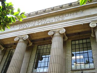
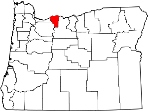
    Washington County is one of 36 counties in the U.S. state of Oregon and part of the Portland metropolitan area. The 2020 census recorded the population as 600,372, making it the second most populous county in the state and most populous "Washington County" in the United States. Hillsboro is the county seat and largest city, while other major cities include Beaverton, Tigard, Cornelius, Banks, Gaston, Sherwood, North Plains, and Forest Grove, the county's oldest city. Originally named Twality when created in 1843, the Oregon Territorial Legislature renamed it for the nation's first president in 1849 and included the entire northwest corner of Oregon before new counties were created in 1854. The Tualatin River and its drainage basin lie almost entirely within the county, which shares its boundaries with the Tualatin Valley. It is bordered on the west and north by the Northern Oregon Coast Range, on the south by the Chehalem Mountains, and on the north and east by the Tualatin Mountains, or West Hills.

    <span class="mw-page-title-main">Skamania County, Washington</span> County in Washington, United States

    Skamania County is a county located in the U.S. state of Washington. As of the 2020 census, the population was 12,036. The county seat and largest incorporated city is Stevenson, although the Carson River Valley CDP is more populous. Skamania County is included in the Portland-Vancouver-Hillsboro, OR-WA Metropolitan Statistical Area.

    <span class="mw-page-title-main">Wasco County, Oregon</span> County in Oregon, United States

    Wasco County is one of the 36 counties in the U.S. state of Oregon. As of the 2020 census, the population was 25,213. Its county seat is The Dalles. The county is named for a local tribe of Native Americans, the Wasco, a Chinook tribe who live on the south side of the Columbia River. It is near the Washington state line. Wasco County comprises The Dalles Micropolitan Statistical Area.

    <span class="mw-page-title-main">Union County, Oregon</span> County in Oregon, United States

    Union County is one of the 36 counties in the U.S. state of Oregon, and one of the 8 counties of eastern Oregon. As of the 2020 census, the population was 26,196. The county comprises the La Grande micropolitan statistical area and the county seat is La Grande.

    <span class="mw-page-title-main">Sherman County, Oregon</span> County in Oregon, United States

    Sherman County is one of the 36 counties in the U.S. state of Oregon. As of the 2020 census, the population was 1,870, making it the second-least populous county in Oregon after nearby Wheeler. The county seat is Moro, and the largest city is Wasco. The county is named for William Tecumseh Sherman, a Union general in the American Civil War.

    <span class="mw-page-title-main">Polk County, Oregon</span> County in Oregon, United States

    Polk County is one of the 36 counties in the U.S. state of Oregon. As of the 2020 census, the population was 87,433. The county seat is Dallas. The county is named for James Knox Polk, the 11th president of the United States.

    <span class="mw-page-title-main">Multnomah County, Oregon</span> County in Oregon, United States

    Multnomah County is one of the 36 counties in the U.S. state of Oregon. As of the 2020 census, the county's population was 815,428. Multnomah County is part of the Portland–Vancouver–Hillsboro, OR–WA metropolitan statistical area. Though smallest in area, Multnomah County is the state's most populous county. Its county seat, Portland, is the state's largest city.

    <span class="mw-page-title-main">Jefferson County, Oregon</span> County in Oregon, United States

    Jefferson County is one of the 36 counties in the U.S. state of Oregon. At the 2020 census, the population was 24,502. The county seat is Madras. The county is named after Mount Jefferson, the second tallest mountain in Oregon.

    <span class="mw-page-title-main">Grant County, Oregon</span> County in Oregon, United States

    Grant County is one of the 36 counties in the U.S. state of Oregon. As of the 2020 census, the population was 7,233, making it Oregon's fourth-least populous county. The county seat is Canyon City. It is named for President Ulysses S. Grant, who served as an army officer in the Oregon Territory, and at the time of the county's creation was a Union general in the American Civil War.

    <span class="mw-page-title-main">Gilliam County, Oregon</span> County in Oregon, United States

    Gilliam County is one of the 36 counties in the U.S. state of Oregon. As of the 2020 census, the population was 1,995, making it the third-least populous county in Oregon. The county seat is Condon. The county was established in 1885 and is named for Cornelius Gilliam, a colonel who commanded the forces of the provisional government of Oregon after the Whitman Massacre.

    <span class="mw-page-title-main">Deschutes County, Oregon</span> County in Oregon, United States

    Deschutes County is one of the 36 counties in the U.S. state of Oregon. As of the 2020 census, the population was 198,253. The county seat is Bend. The county was created in 1916 out of part of Crook County and was named for the Deschutes River, which itself was named by French-Canadian trappers of the early 19th century. It is the political and economic hub of Central Oregon. Deschutes comprises the Bend, Oregon Metropolitan Statistical Area and media market. Deschutes is Oregon's fastest-growing and most recently formed county.

    <span class="mw-page-title-main">Clackamas County, Oregon</span> County in Oregon, United States

    Clackamas County is one of the 36 counties in the U.S. state of Oregon. As of the 2020 census, the population was 421,401, making it Oregon's third-most populous county. Its county seat is Oregon City. The county was named after the native people living in the area at the time of the coming of Europeans, the Clackamas people, who are part of the Chinookan peoples.

    <span class="mw-page-title-main">Knox County, Indiana</span> County in Indiana, United States

    Knox County is a county in the U.S. state of Indiana in the United States. The oldest county in Indiana, it was one of two original counties created in the Northwest Territory in 1790, alongside St. Clair County, Illinois. Knox County was gradually reduced in size as subsequent counties were established. It was established in its present configuration when Daviess County was partitioned off. At the 2020 United States Census, the county population was 36,282. The county seat is Vincennes.

    <span class="mw-page-title-main">Mount Hood Village, Oregon</span> Unincorporated community in the state of Oregon, United States

    Mount Hood Village is the name of a census-designated place (CDP) within the Mount Hood Corridor in Clackamas County, Oregon, United States. As of the 2010 census, the CDP had a population of 4,864. The Villages at Mount Hood is the name of the combined government of several of the communities encompassed by the CDP and is a separate entity.

    <span class="mw-page-title-main">Cascade Locks, Oregon</span> City in Oregon, United States

    Cascade Locks is a city in Hood River County, Oregon, United States. The city got its name from a set of locks built to improve navigation past the Cascades Rapids of the Columbia River. The U.S. federal government approved the plan for the locks in 1875, construction began in 1878, and the locks were completed on November 5, 1896. The locks were subsequently submerged in 1938, replaced by Bonneville Lock and Dam, although the city did not lose land from the expansion of Lake Bonneville behind the dam some 4 miles (6 km) downstream of the city. The city population was 1,144 at the 2010 census.

    <span class="mw-page-title-main">Hood River, Oregon</span> City in Oregon, United States

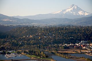
    Hood River is a city and the seat of Hood River County, Oregon, United States. It is a port on the Columbia River, and is named for the nearby Hood River. As of the 2020 census, the city population was 8,313. It is the only city in Oregon where public consumption of alcohol on sidewalks or parks is totally unrestricted.

    <span class="mw-page-title-main">Parkdale, Oregon</span> Unincorporated community in the state of Oregon, United States

    Parkdale is an unincorporated community and census-designated place (CDP) in Hood River County, Oregon, United States. As of the 2010 census, the population was 311, up from 266 at the 2000 census.

    <span class="mw-page-title-main">Troutdale, Oregon</span> City in Oregon, United States

    Troutdale is a city in Multnomah County, Oregon, United States, immediately north of Gresham and east of Wood Village. As of the 2020 census, the city population was 16,300. The city serves as the western gateway to the Historic Columbia River Highway, the Mount Hood Scenic Byway, and the Columbia River Gorge. It is approximately 12 miles (19 km) east of Portland.

    <span class="mw-page-title-main">The Dalles, Oregon</span> City in the United States

    The Dalles, formally the City of The Dalles and also called Dalles City, is an inland port and the largest city in Wasco County, Oregon, United States. The population was 16,010 at the 2020 census, and it is the largest city in Oregon along the Columbia River outside the Portland Metropolitan Area. The Dalles is 75 miles east of Portland, within the Columbia River Gorge National Scenic Area.

    References

    1. 1 2 "State & County QuickFacts". United States Census Bureau. Retrieved May 20, 2023.
    2. "Find a County". National Association of Counties. Archived from the original on May 31, 2011. Retrieved June 7, 2011.
    3. "2010 Census Gazetteer Files". United States Census Bureau. August 22, 2012. Retrieved February 25, 2015.
    4. 1 2 "Hood River County Chamber of Commerce".
    5. "Mount Hood Wilderness". United States Department of Agriculture, Forest Service. Retrieved October 15, 2015.
    6. "Climate of Hood River". Prepared by George Taylor, state climatologist, Cadee Hale & Sarah Joos, publication assistants. Archived from the original on March 8, 2016. Retrieved October 18, 2015.
    7. "Hood River Watershed Assessment, December 1999" (PDF). Holly Coccoli, Hood River Watershed Group. Archived (PDF) from the original on October 9, 2022.
    8. "Table 6 - NFS Acreage by State, Congressional District and County, October 10, 2007".
    9. "Hood River County Forestry Department, Hood River County, Oregon".
    10. "State of Oregon State Land Inventory Report" (PDF). Department of State Lands, Salem, Oregon. Archived (PDF) from the original on October 9, 2022.
    11. "Weyerhaeuser Completes Acquisition of Longview Timber LLC". Weyerhaeuser, Federal Way, Wash, July 23, 2013.
    12. "Table 1. County Summary Highlights: 2012 Census of Agriculture" (PDF). United States Department of Agriculture, National Agricultural Statistics Service. Archived (PDF) from the original on October 9, 2022. Retrieved October 15, 2015.
    13. "Annual Estimates of the Resident Population for Counties: April 1, 2020 to July 1, 2023". United States Census Bureau. Retrieved March 24, 2024.
    14. "U.S. Decennial Census". United States Census Bureau. Retrieved February 25, 2015.
    15. "Historical Census Browser". University of Virginia Library. Retrieved February 25, 2015.
    16. Forstall, Richard L., ed. (March 27, 1995). "Population of Counties by Decennial Census: 1900 to 1990". United States Census Bureau. Retrieved February 25, 2015.
    17. "Census 2000 PHC-T-4. Ranking Tables for Counties: 1990 and 2000" (PDF). United States Census Bureau. April 2, 2001. Archived from the original (PDF) on February 26, 2015. Retrieved February 25, 2015.
    18. 1 2 3 "DP-1 Profile of General Population and Housing Characteristics: 2010 Demographic Profile Data". United States Census Bureau. Archived from the original on February 13, 2020. Retrieved February 23, 2016.
    19. "Population, Housing Units, Area, and Density: 2010 - County". United States Census Bureau. Archived from the original on February 13, 2020. Retrieved February 23, 2016.
    20. "DP02 SELECTED SOCIAL CHARACTERISTICS IN THE UNITED STATES – 2006-2010 American Community Survey 5-Year Estimates". United States Census Bureau. Archived from the original on February 13, 2020. Retrieved February 23, 2016.
    21. "DP03 SELECTED ECONOMIC CHARACTERISTICS – 2006-2010 American Community Survey 5-Year Estimates". United States Census Bureau. Archived from the original on February 13, 2020. Retrieved February 23, 2016.
    22. "U.S. Census website". United States Census Bureau . Retrieved October 15, 2015.
    23. "Income in the Past 12 Month, 2006-2010 American Community Survey 5-Year Estimate". United States Census Bureau . Retrieved October 15, 2015.
    24. "Decennial Census, Poverty Rates by County". United States Census Bureau . Retrieved October 15, 2015.
    25. "Language Spoken at Home, 2006-2010 American Community Survey 5-Year Estimate". United States Census Bureau . Retrieved October 15, 2015.
    26. "Hood River County Home Rule Charter". Hood River County, Oregon.
    27. "Hood River County, Oregon, Comprehensive Annual Financial Report for fiscal year ended June 30, 2014". Hood River County.
    28. "Norcor Home Archived November 24, 2011, at the Wayback Machine ." Northern Oregon Regional Corrections Facility. Retrieved on November 22, 2011.
    29. Leip, David. "Dave Leip's Atlas of U.S. Presidential Elections". uselectionatlas.org. Retrieved April 11, 2018.
    30. "Bureau of Economic Analysis". United States Department of Commerce. Retrieved October 15, 2015.
    31. "Oregon Regional Economic Analysis Project". Oregon Regional Economic Analysis Project. Retrieved October 15, 2015.
    32. "Mount Hood Railroad". Iowa Pacific Holdings.

    45°31′03″N121°38′58″W / 45.51750°N 121.64944°W / 45.51750; -121.64944