Jefferson County, Oregon

Last updated

Jefferson County
MadrasJeffersoncourthouse.jpg
Jefferson County Courthouse in Madras
Map of Oregon highlighting Jefferson County.svg
Location within the U.S. state of Oregon
Oregon in United States.svg
Oregon's location within the U.S.
Coordinates: 44°38′N121°10′W / 44.63°N 121.17°W / 44.63; -121.17
CountryFlag of the United States.svg United States
StateFlag of Oregon.svg  Oregon
FoundedDecember 12, 1914
Named for Mount Jefferson
Seat Madras
Largest cityMadras
Area
  Total1,791 sq mi (4,640 km2)
  Land1,781 sq mi (4,610 km2)
  Water10 sq mi (30 km2)  0.6%
Population
 (2020)
  Total24,502
  Estimate 
(2023)
25,454 Increase2.svg
  Density12/sq mi (5/km2)
Time zone UTC−8 (Pacific)
  Summer (DST) UTC−7 (PDT)
Congressional districts 2nd, 5th
Website www.co.jefferson.or.us

Jefferson County is one of the 36 counties in the U.S. state of Oregon. At the 2020 census, the population was 24,502. [1] The county seat is Madras. [2] The county is named after Mount Jefferson, the second tallest mountain in Oregon. [3]

Contents

History

Jefferson County was created on December 12, 1914, from a portion of Crook County. The county owes much of its agricultural prosperity to the railroad, which links Madras with the Columbia River, and was completed in 1911, and to the development of irrigation projects in the late 1930s. The railroad was completed despite constant feuds and battles between two lines working on opposite sides of the Deschutes River.

Madras was incorporated in 1911, and has been the permanent county seat since a general election in 1916. The first (temporary) county seat was Culver, which was selected by a three-man commission appointed by the governor. Due to repeated tie votes over several days (with one vote each cast for Culver, Metolius and Madras). The deadlock was eventually broken by allowing the Metolius Commissioner to post the tie-breaker, by voting for Culver.[ citation needed ]

Rapid development in adjacent Deschutes County during the 1990s had farmers in Jefferson County concerned that they might be priced out of their own farmlands, which could be replaced by destination resorts, golf courses and other amenities for recent arrivals.[ citation needed ]

Geography

Map of Jefferson County Jefferson County.svg
Map of Jefferson County

According to the United States Census Bureau, the county has a total area of 1,791 square miles (4,640 km2), of which 1,781 square miles (4,610 km2) is land and 10 square miles (26 km2) (0.6%) is water. [4]

Adjacent counties

National protected areas

Demographics

Historical population
CensusPop.Note
1920 3,211
1930 2,291−28.7%
1940 2,042−10.9%
1950 5,536171.1%
1960 7,13028.8%
1970 8,54819.9%
1980 11,59935.7%
1990 13,67617.9%
2000 19,00939.0%
2010 21,72014.3%
2020 24,50212.8%
2023 (est.)25,454 [5] 3.9%
U.S. Decennial Census [6]
1790–1960 [7] 1900–1990 [8]
1990–2000 [9] 2010–2020 [1]
From 2000 to 2007, Jefferson County's population grew by 15.9%, more than twice the national average. It was the third fastest growing county in the state, after neighboring Deschutes and Crook counties. Oregon Population Growth by County.png
From 2000 to 2007, Jefferson County's population grew by 15.9%, more than twice the national average. It was the third fastest growing county in the state, after neighboring Deschutes and Crook counties.

2010 census

As of the 2010 census, there were 21,720 people, 7,790 households and 5,646 families living in the county. [10] The population density was 12.2 per square mile (4.7/km2). There were 9,815 housing units at an average density of 5.5 per square mile (2.1/km2). [11] The racial make-up was 69.0% white, 16.9% American Indian, 0.6% black or African American, 0.4% Asian, 0.1% Pacific islander, 9.1% from other races, and 3.8% from two or more races. Those of Hispanic or Latino origin made up 19.3% of the population. [10] In terms of ancestry, 15.0% were German, 9.4% were Irish, 8.3% were English, and 4.9% were American. [12]

Of the 7,790 households, 34.0% had children under the age of 18 living with them, 53.6% were married couples living together, 12.6% had a female householder with no husband present, 27.5% were non-families, and 22.2% of all households were made up of individuals. The average household size was 2.68 and the average family size was 3.11. The median age was 39.6 years. [10]

The median household income was $41,425 and the median family income was $48,818. Males had a median income of $37,370 and females $30,047. The per capita income was $20,009. About 13.5% of families and 20.1% of the population were below the poverty line, including 33.6% of those under age 18 and 6.5% of those age 65 or over. [13]

2000 census

As of the 2000 census, there were 19,009 people, 6,727 households and 5,166 families living in the county. The population density was 11 per square mile (4.2/km2). There were 8,319 housing units at an average density of 5 per square mile (1.9/km2). The racial make-up was 68.98% White, 0.26% Black or African American, 15.68% Native American, 0.30% Asian, 0.22% Pacific Islander, 11.32% from other races, and 3.23% from two or more races. 17.74% of the population were Hispanic or Latino of any race. 13.6% were of German, 9.5% English, 8.7% American and 5.3% Irish ancestry. 82.2% spoke English, 15.5% Spanish and 1.0% Sahaptian as their first language.

There were 6,727 households, of which 35.60% had children under the age of 18 living with them, 60.50% were married couples living together, 10.50% had a female householder with no husband present, and 23.20% were non-families. 18.60% of all households were made up of individuals, and 6.90% had someone living alone who was 65 years of age or older. The average household size was 2.80 and the average family size was 3.16.

29.80% of the population were under the age of 18, 7.70% from 18 to 24, 26.90% from 25 to 44, 23.20% from 45 to 64, and 12.40% who were 65 years of age or older. The median age was 35 years. For every 100 females there were 101.90 males. For every 100 females age 18 and over, there were 100.80 males.

The median household income was $35,853 and the median family income was $39,151. Males had a median income of $31,126 and females $22,086s. The per capita income was $15,675. About 10.40% of families and 14.60% of the population were below the poverty line, including 22.20% of those under age 18 and 5.90% of those age 65 or over.

Communities

Cities

Census-designated places

Unincorporated communities

Politics

United States presidential election results for Jefferson County, Oregon [14]
Year Republican Democratic Third party
No.%No.%No.%
2020 7,18960.35%4,39336.88%3312.78%
2016 5,48357.97%2,98031.50%99610.53%
2012 4,64256.78%3,30140.38%2322.84%
2008 4,40252.92%3,68244.27%2342.81%
2004 4,76258.68%3,24339.96%1101.36%
2000 3,83855.65%2,68138.87%3785.48%
1996 2,63442.52%2,55541.24%1,00616.24%
1992 1,96233.22%2,16136.59%1,78330.19%
1988 2,50950.23%2,34646.97%1402.80%
1984 3,28362.94%1,92036.81%130.25%
1980 2,52353.26%1,65434.92%56011.82%
1976 1,81047.92%1,76946.84%1985.24%
1972 1,81656.38%1,22938.16%1765.46%
1968 1,66955.26%1,16038.41%1916.32%
1964 1,19740.74%1,73959.19%20.07%
1960 1,41353.75%1,21446.18%20.08%
1956 1,35654.83%1,11745.17%00.00%
1952 1,48867.12%72332.61%60.27%
1948 62250.69%55945.56%463.75%
1944 41957.95%29741.08%70.97%
1940 42347.21%46752.12%60.67%
1936 25331.51%51464.01%364.48%
1932 25333.03%47762.27%364.70%
1928 48159.31%30837.98%222.71%
1924 37439.00%24225.23%34335.77%
1920 62361.56%30029.64%898.79%
1916 58136.13%90456.22%1237.65%
Political orientations in Jefferson County, Oregon (2009) Political orientations in Jefferson County, Oregon (2009).gif
Political orientations in Jefferson County, Oregon (2009)

Though Jefferson County is located in central Oregon, politically it falls in line with the eastern side of the state. The majority of registered voters who are part of a political party in Jefferson County, as well as most counties in eastern Oregon, are members of the Republican Party. [15] No Democrat has won the majority of the votes in Jefferson County since Lyndon B. Johnson in 1964; the last Democrat to carry the county in a presidential election was Bill Clinton in 1992. In the 2008 presidential election, 51.47% of Jefferson County voters voted for Republican John McCain, while 43.05% voted for Democrat Barack Obama and 5.46% of voters either voted for a Third Party candidate or wrote in a candidate. [16] These numbers show a small shift towards the Democratic candidate as well as a Third Party candidate when compared to the 2004 presidential election, in which 58.7% of Jefferson Country voters voted for George W. Bush, while 40% voted for John Kerry, and 1.3% of voters either voted for a Third Party candidate or a write-in candidate. [17]

Economy

Agriculture is the predominant source of income in the county, with vegetable, grass and flower seeds, garlic, mint and sugar beets cultivated on some 60,000 acres (240 km2) of irrigated land. Jefferson County also has vast rangelands and until 2016 had an industrial base related to forest products. The Warm Springs Forest Products Industry, a multimillion-dollar complex owned by the Confederated Tribes of Warm Springs partially located in the northwestern corner of the county was the single biggest industry. With 300 days of sunshine and a low yearly rainfall, fishing, hunting, camping, boating, water-skiing and rock hunting are major tourist activities.

The major landowners in the county are the Forest Service, which manages National Forest System Lands the comprise 24% of the lands within the county boundaries, and the Confederated Tribes of Warm Springs-Warm Springs Reservation, which owns and manages 21% of the lands within the county boundaries.

See also

Related Research Articles

<span class="mw-page-title-main">Wheeler County, Oregon</span> County in Oregon, United States

Wheeler County is a county in the U.S. state of Oregon. As of the 2020 census, the population was 1,451, making it Oregon's least populous county. It is named in honor of Henry H. Wheeler. an early settler who owned a farm near Mitchell. The county seat is Fossil, and Wheeler County is known for having Oregon's largest deposit of fossils.

<span class="mw-page-title-main">Wasco County, Oregon</span> County in Oregon, United States

Wasco County is one of the 36 counties in the U.S. state of Oregon. As of the 2020 census, the population was 25,213. Its county seat is The Dalles. The county is named for a local tribe of Native Americans, the Wasco, a Chinook tribe who live on the south side of the Columbia River. It is near the Washington state line. Wasco County comprises The Dalles Micropolitan Statistical Area.

<span class="mw-page-title-main">Union County, Oregon</span> County in Oregon, United States

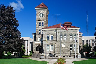
Union County is one of the 36 counties in the U.S. state of Oregon, and one of the 8 counties of eastern Oregon. As of the 2020 census, the population was 26,196. The county comprises the La Grande micropolitan statistical area and the county seat is La Grande.

<span class="mw-page-title-main">Sherman County, Oregon</span> County in Oregon, United States

Sherman County is one of the 36 counties in the U.S. state of Oregon. As of the 2020 census, the population was 1,870, making it the second-least populous county in Oregon after nearby Wheeler. The county seat is Moro, and the largest city is Wasco. The county is named for William Tecumseh Sherman, a Union general in the American Civil War.

<span class="mw-page-title-main">Polk County, Oregon</span> County in Oregon, United States

Polk County is one of the 36 counties in the U.S. state of Oregon. As of the 2020 census, the population was 87,433. The county seat is Dallas. The county is named for James Knox Polk, the 11th president of the United States.

<span class="mw-page-title-main">Morrow County, Oregon</span> County in Oregon, United States

Morrow County is one of the 36 counties in the U.S. state of Oregon. As of the 2020 census, the population was 12,186. The county seat is Heppner. The county is named for one of its first settlers, Jackson L. Morrow, who was a member of the state legislature when the county was created. Half of the Umatilla Chemical Depot, which includes the Umatilla Chemical Agent Disposal Facility, and the Naval Weapons Systems Training Facility Boardman are located within the county. Morrow County is part of the Pendleton-Hermiston, OR, Micropolitan Statistical Area. It is located on the south side of the Columbia River and is included in the eight-county definition of Eastern Oregon.

<span class="mw-page-title-main">Marion County, Oregon</span> County in Oregon, United States

Marion County is one of the 36 counties in the U.S. state of Oregon. The population was 345,920 at the 2020 census, making it the 5th most populous county in Oregon. The county seat is Salem, which is also the state capital of Oregon. The county was originally named the Champooick District, after Champoeg, a meeting place on the Willamette River. On September 3, 1849, the territorial legislature renamed it in honor of Francis Marion, a Continental Army general from South Carolina who served in the American Revolutionary War.

<span class="mw-page-title-main">Lake County, Oregon</span> County in Oregon, United States

Lake County is one of the 36 counties in the U.S. state of Oregon. As of the 2020 census, the population was 8,160. Its county seat is Lakeview. The county is named after the many lakes found within its boundaries, including Lake Abert, Summer Lake, Hart Lake, and Goose Lake.

<span class="mw-page-title-main">Klamath County, Oregon</span> County in Oregon, United States

Klamath County is one of the 36 counties in the U.S. state of Oregon. As of the 2020 census, the population was 69,413. The county seat is Klamath Falls. The county was named for the Klamath, the tribe of Native Americans living in the area at the time the first European explorers entered the region. Klamath County comprises the Klamath Falls, OR Micropolitan Statistical Area.

<span class="mw-page-title-main">Harney County, Oregon</span> County in Oregon, United States

Harney County is one of the 36 counties in the U.S. state of Oregon. As of the 2020 census, the population was 7,495, making it the sixth-least populous county in Oregon. The county seat is Burns. Established in 1889, the county is named in honor of William S. Harney, a military officer of the period, who was involved in the Pig War and popular in the Pacific Northwest.

<span class="mw-page-title-main">Deschutes County, Oregon</span> County in Oregon, United States

Deschutes County is one of the 36 counties in the U.S. state of Oregon. As of the 2020 census, the population was 198,253. The county seat is Bend. The county was created in 1916 out of part of Crook County and was named for the Deschutes River, which itself was named by French-Canadian trappers of the early 19th century. It is the political and economic hub of Central Oregon. Deschutes comprises the Bend, Oregon Metropolitan Statistical Area and media market. Deschutes is Oregon's fastest-growing and most recently formed county.

<span class="mw-page-title-main">Crook County, Oregon</span> County in Oregon, United States

Crook County is one of the 36 counties in the U.S. state of Oregon. As of the 2020 census, the population was 24,738. The county seat is Prineville. The county is named after George Crook, a U.S. Army officer who served in the American Civil War and various Indian Wars.

<span class="mw-page-title-main">Deschutes River Woods, Oregon</span> Unincorporated community in the state of Oregon, United States

Deschutes River Woods is a census-designated place (CDP) and unincorporated community in Deschutes County, Oregon, United States. It is part of the Bend, Oregon Metropolitan Statistical Area. The population was 5,077 at the 2010 census.

<span class="mw-page-title-main">Terrebonne, Oregon</span> Unincorporated community in the state of Oregon, United States

Terrebonne is an unincorporated community and census-designated place (CDP) in Deschutes County, Oregon, United States. It is part of the Bend, Oregon Metropolitan Statistical Area. The population was 1,257 at the 2010 census.

<span class="mw-page-title-main">Three Rivers South, Oregon</span> Unincorporated community in the state of Oregon, United States

Three Rivers South is a census-designated place (CDP) and unincorporated community in Deschutes County, Oregon, United States. It is part of the Bend, Oregon Metropolitan Statistical Area. The population was 3,014 at the 2010 census.

<span class="mw-page-title-main">Culver, Oregon</span> City in Oregon, United States

Culver is a city in Jefferson County, Oregon, United States. The population was 1,357 at the 2010 census.

<span class="mw-page-title-main">Metolius, Oregon</span> City in Oregon, United States

Metolius is a city in Jefferson County, Oregon, United States, named for the Metolius River, a nearby tributary of the Deschutes River. The name for both comes from the Warm Springs or Sahaptin word mitula, meaning white salmon and referring to a light colored Chinook salmon and not a whitefish. The population was 710 at the 2010 census.

<span class="mw-page-title-main">Warm Springs, Oregon</span> Unincorporated community in the state of Oregon, United States

Warm Springs is a census-designated place (CDP) and an unincorporated community in Jefferson County, Oregon, United States. Located on the Warm Springs Indian Reservation, the community is also known as the "Warm Springs Agency". The population was 2,945 at the 2010 census, up from 2,431 at the 2000 census.

<span class="mw-page-title-main">Jefferson, Oregon</span> City in Oregon, United States

Jefferson is a city in Marion County, Oregon, United States. It is part of the Salem Metropolitan Statistical Area. The population was 3,327 at the 2020 census. The city sits on the right bank of the Santiam River between Salem and Albany along Oregon Route 164 east of Interstate 5.

<span class="mw-page-title-main">Maupin, Oregon</span> City in Oregon, United States

Maupin is a city in Wasco County, Oregon, United States. Located on the Deschutes River, much of the city's economy is related to the river through outdoor activities, such as fishing and rafting. The population was 418 at the 2010 census.

References

  1. 1 2 "State & County QuickFacts". United States Census Bureau. Retrieved May 20, 2023.
  2. "Find a County". National Association of Counties. Archived from the original on May 31, 2011. Retrieved June 7, 2011.
  3. McArthur, Lewis A.; McArthur, Lewis L. (2003) [1928]. Oregon Geographic Names (7th ed.). Portland, Oregon: Oregon Historical Society Press. p. 509. ISBN   978-0875952772.
  4. "2010 Census Gazetteer Files". United States Census Bureau. August 22, 2012. Retrieved February 26, 2015.
  5. "Annual Estimates of the Resident Population for Counties: April 1, 2020 to July 1, 2023". United States Census Bureau. Retrieved March 24, 2024.
  6. "U.S. Decennial Census". United States Census Bureau. Retrieved February 26, 2015.
  7. "Historical Census Browser". University of Virginia Library. Retrieved February 26, 2015.
  8. Forstall, Richard L., ed. (March 27, 1995). "Population of Counties by Decennial Census: 1900 to 1990". United States Census Bureau. Retrieved February 26, 2015.
  9. "Census 2000 PHC-T-4. Ranking Tables for Counties: 1990 and 2000" (PDF). United States Census Bureau. April 2, 2001. Archived from the original (PDF) on February 26, 2015. Retrieved February 26, 2015.
  10. 1 2 3 "DP-1 Profile of General Population and Housing Characteristics: 2010 Demographic Profile Data". United States Census Bureau. Archived from the original on February 13, 2020. Retrieved February 23, 2016.
  11. "Population, Housing Units, Area, and Density: 2010 - County". United States Census Bureau. Archived from the original on February 13, 2020. Retrieved February 23, 2016.
  12. "DP02 SELECTED SOCIAL CHARACTERISTICS IN THE UNITED STATES – 2006-2010 American Community Survey 5-Year Estimates". United States Census Bureau. Archived from the original on February 13, 2020. Retrieved February 23, 2016.
  13. "DP03 SELECTED ECONOMIC CHARACTERISTICS – 2006-2010 American Community Survey 5-Year Estimates". United States Census Bureau. Archived from the original on February 13, 2020. Retrieved February 23, 2016.
  14. Leip, David. "Dave Leip's Atlas of U.S. Presidential Elections". US Election Atlas. Retrieved April 11, 2018.
  15. "2018 October voter registration". Oregon Secretary of State. November 15, 2018. p. 2. Archived from the original on July 23, 2019. Retrieved November 20, 2018.
  16. "[no title cited]" . Retrieved May 20, 2009.[ permanent dead link ]
  17. "[no title cited]" . Retrieved April 21, 2009.

44°38′N121°10′W / 44.63°N 121.17°W / 44.63; -121.17