Glendale, Oregon

Last updated
Glendale, Oregon
Glendale High School pirate ship entrance - Glendale Oregon.jpg
Douglas County Oregon Incorporated and Unincorporated areas Glendale Highlighted.svg
Location in Oregon
Coordinates: 42°44′13″N123°25′42″W / 42.73694°N 123.42833°W / 42.73694; -123.42833 Coordinates: 42°44′13″N123°25′42″W / 42.73694°N 123.42833°W / 42.73694; -123.42833
Country United States
State Oregon
County Douglas
Incorporated 1901
Government
   Mayor Lucille Martin [1]
Area
[2]
  Total0.39 sq mi (1.02 km2)
  Land0.39 sq mi (1.02 km2)
  Water0.00 sq mi (0.00 km2)
Elevation
1,410 ft (430 m)
Population
 (2020) [3]
  Total858
  Density2,188.78/sq mi (844.57/km2)
Time zone UTC-8 (Pacific)
  Summer (DST) UTC-7 (Pacific)
ZIP code
97442
Area code 541
FIPS code 41-29350 [4]
GNIS feature ID1166658 [5]
Website www.cityofglendaleor.com

Glendale is a city in Douglas County, Oregon, United States. The population was 874 at the 2010 census.

Contents

History

A historic view of Glendale Birds eye view of Glendale, Oregon (3229822290).jpg
A historic view of Glendale

After construction of a railroad line south from Roseburg in 1881–83, Solomon Abraham, the local right-of-way agent, platted the community and named it "Julia" after his wife. After a dispute with Abraham, A. F. Morris, the chief engineer for the railroad, changed the name to "Glendale". A Julia post office was established in February 1883, and its name was changed to Glendale in August of the same year. L. D. Montgomery was the first postmaster. Fire destroyed much of Glendale's business district in 1928. Glendale was quickly rebuilt.

In the 1880s, Russian-Jewish immigrants came here trying to escape the anti-Semitic rule of Alexander III. New Odessa, the first Jewish Communitarian Community in America settled near Glendale. By 1888 the New Odessa Community disbanded due to political and religious division.

Glendale was incorporated in 1901.

Historic Marker donated by the Jewish American Society for Historic Preservation in city park Glendale Marker.jpg
Historic Marker donated by the Jewish American Society for Historic Preservation in city park

[6]

Geography

According to the United States Census Bureau, the city has a total area of 0.40 square miles (1.04 km2), all of it land. [7]

Demographics

Historical population
CensusPop.
1910 646
1920 548−15.2%
1930 516−5.8%
1940 5577.9%
1950 87156.4%
1960 748−14.1%
1970 709−5.2%
1980 7120.4%
1990 707−0.7%
2000 85520.9%
2010 8742.2%
2020 858−1.8%
U.S. Decennial Census [8] [3]

2010 census

As of the census of 2010, there were 874 people, 325 households, and 229 families living in the city. The population density was 2,185.0 inhabitants per square mile (843.6/km2). There were 391 housing units at an average density of 977.5 per square mile (377.4/km2). The racial makeup of the city was 89.8% White, 0.3% African American, 1.4% Native American, 0.1% Asian, 3.8% from other races, and 4.6% from two or more races. Hispanic or Latino of any race were 9.4% of the population. [4]

There were 325 households, of which 38.2% had children under the age of 18 living with them, 51.4% were married couples living together, 11.1% had a female householder with no husband present, 8.0% had a male householder with no wife present, and 29.5% were non-families. 22.5% of all households were made up of individuals, and 9.6% had someone living alone who was 65 years of age or older. The average household size was 2.69 and the average family size was 3.14. [4]

The median age in the city was 35.8 years. 29.4% of residents were under the age of 18; 8% were between the ages of 18 and 24; 24.5% were from 25 to 44; 23.9% were from 45 to 64; and 14.3% were 65 years of age or older. The gender makeup of the city was 50.8% male and 49.2% female. [4]

2000 census

As of the census of 2000, there were 855 people, 311 households, and 224 families living in the city. The population density was 2,138.4 people per square mile (825.3/km2). There were 355 housing units at an average density of 887.9 per square mile (342.7/km2). The racial makeup of the city was 89.82% White, 2.92% Native American, 1.05% Asian, 0.12% Pacific Islander, 2.34% from other races, and 3.74% from two or more races. Hispanic or Latino of any race were 8.54% of the population. [4]

There were 311 households, out of which 40.5% had children under the age of 18 living with them, 49.8% were married couples living together, 12.9% had a female householder with no husband present, and 27.7% were non-families. 23.2% of all households were made up of individuals, and 7.1% had someone living alone who was 65 years of age or older. The average household size was 2.75 and the average family size was 3.23. [4]

In the city, the population was spread out, with 35.6% under the age of 18, 7.8% from 18 to 24, 26.9% from 25 to 44, 20.8% from 45 to 64, and 8.9% who were 65 years of age or older. The median age was 31 years. For every 100 females, there were 97.5 males. For every 100 females age 18 and over, there were 96.8 males. [4]

The median income for a household in the city was $27,625, and the median income for a family was $30,278. Males had a median income of $34,167 versus $17,143 for females. The per capita income for the city was $13,067. About 19.4% of families and 22.4% of the population were below the poverty line, including 26.6% of those under age 18 and 15.2% of those age 65 or over. [4]

See also

Related Research Articles

<span class="mw-page-title-main">Adams County, Idaho</span> County in Idaho, United States

Adams County is a rural county in the state of Idaho. As of the 2020 census, the county had a population of 4,379, making it the fifth-least populous county in Idaho. The county seat and largest city is Council. Established in 1911, the county was named for second U.S. President John Adams.

<span class="mw-page-title-main">Glendale, Missouri</span> City in Missouri, United States

Glendale is a city in St. Louis County, Missouri, United States. The population was 5,925 at the 2010 census.

<span class="mw-page-title-main">Haines, Oregon</span> City in Oregon, United States

Haines is a city in Baker County, Oregon, United States. The population was 416 at the 2010 census.

<span class="mw-page-title-main">Barlow, Oregon</span> City in Oregon, United States

Barlow is a city in Clackamas County, Oregon, United States. The population was 135 at the 2010 census. The mayor of Barlow is Michael Lundsten, as of the most recent election in 2018.

<span class="mw-page-title-main">Canyonville, Oregon</span> City in Oregon, United States

Canyonville is a city in Douglas County, Oregon, United States. The population was 1,884 at the 2010 census. The main regional tourist attraction, the Seven Feathers Casino Resort is in Canyonville.

<span class="mw-page-title-main">Yoncalla, Oregon</span> City in Oregon, United States

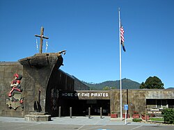
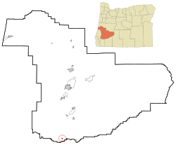
Yoncalla is a city in Douglas County, Oregon, United States. The population was 1,047 at the 2010 census.

<span class="mw-page-title-main">Dunes City, Oregon</span> City in Oregon, United States

Dunes City is a city in Lane County, Oregon, United States. The population was 1,303 at the 2010 census.

<span class="mw-page-title-main">Halsey, Oregon</span> City in Oregon, United States

Halsey is a city in Linn County, Oregon, United States. The population was 904 at the 2010 census.

<span class="mw-page-title-main">Harrisburg, Oregon</span> City in Oregon, United States

Harrisburg is a city in Linn County, Oregon, United States. The population was 3,567 at the 2010 census.

<span class="mw-page-title-main">Sodaville, Oregon</span> City in Oregon, United States

Recorder

<span class="mw-page-title-main">Tangent, Oregon</span> City in Oregon, United States

Tangent is a city in Linn County, Oregon, United States. The population was 1,231 at the 2020 census.

<span class="mw-page-title-main">Donald, Oregon</span> City in Oregon, United States

Donald is a city in Marion County, Oregon, United States. The population was 979 at the 2010 census. It is part of the Salem Metropolitan Statistical Area.

<span class="mw-page-title-main">Sublimity, Oregon</span> City in Oregon, United States

Sublimity is a city in Marion County, Oregon, United States. The population was 2,681 at the 2010 census. It is part of the Salem Metropolitan Statistical Area.

<span class="mw-page-title-main">Turner, Oregon</span> City in Oregon, United States

Turner is a city in Marion County, Oregon, United States. The population was 1,854 at the 2010 census. It is part of the Salem Metropolitan Statistical Area. The community was incorporated by the Oregon Legislative Assembly on February 10, 1905.

<span class="mw-page-title-main">Grass Valley, Oregon</span> City in Oregon, United States

Grass Valley is a city in Sherman County, Oregon, United States. The population was 164 at the 2010 census.

<span class="mw-page-title-main">Rufus, Oregon</span> City in Oregon, United States

Rufus is a city in Sherman County, Oregon, United States. The population was 249 at the 2010 census. The city was named for an early settler, Rufus Carrol Wallis.

<span class="mw-page-title-main">Adams, Oregon</span> City in Oregon, United States

Adams is a city in Umatilla County, Oregon, United States, located about 13 miles (21 km) northeast of Pendleton on Oregon Route 11. The population was 350 at the 2010 census. It is part of the Pendleton–Hermiston Micropolitan Statistical Area.

<span class="mw-page-title-main">Stanfield, Oregon</span> City in Oregon, United States

Stanfield is a city in Umatilla County, Oregon, United States. The population was 2,043 at the 2010 census. It is part of the Pendleton–Hermiston Micropolitan Statistical Area.

<span class="mw-page-title-main">Dundee, Oregon</span> City in Oregon, United States

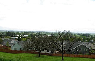
Dundee is a city in Yamhill County, Oregon, United States. The population was 3,162 at the 2010 census.

<span class="mw-page-title-main">Rivergrove, Oregon</span> City in Oregon, United States

Rivergrove is a city in Clackamas County, Oregon, United States. A small portion of the city extends into nearby Washington County. Its name is a portmanteau of the Tualatin River, which forms its southern border, and Lake Grove, a community that is now part of Lake Oswego. The population was 370 at the 2010 census.

References

  1. "Douglas County Election Results (2020)" (PDF). Douglas County Clerk.
  2. "ArcGIS REST Services Directory". United States Census Bureau. Retrieved October 12, 2022.
  3. 1 2 "Census Population API". United States Census Bureau. Retrieved Oct 12, 2022.
  4. 1 2 3 4 5 6 7 8 "U.S. Census website". United States Census Bureau . Retrieved 2012-12-21.
  5. "US Board on Geographic Names". United States Geological Survey. 2007-10-25. Retrieved 2008-01-31.
  6. McArthur, Lewis A.; Lewis L. McArthur (2003) [1928]. Oregon Geographic Names (7th ed.). Portland, Oregon: Oregon Historical Society Press. p. 406. ISBN   0-87595-277-1.
  7. "US Gazetteer files 2010". United States Census Bureau. Archived from the original on January 12, 2012. Retrieved 2012-12-21.
  8. "Census of Population and Housing". Census.gov. Retrieved June 4, 2015.