
Envisat is a large Earth-observing satellite which has been inactive since 2012. It is still in orbit and considered space debris. Operated by the European Space Agency (ESA), it was the world's largest civilian Earth observation satellite.

European Remote Sensing satellite (ERS) was the European Space Agency's first Earth-observing satellite programme using a polar orbit. It consisted of 2 satellites, ERS-1 and ERS-2.

Satellite images are images of Earth collected by imaging satellites operated by governments and businesses around the world. Satellite imaging companies sell images by licensing them to governments and businesses such as Apple Maps and Google Maps.
The Advanced Very-High-Resolution Radiometer (AVHRR) instrument is a space-borne sensor that measures the reflectance of the Earth in five spectral bands that are relatively wide by today's standards. AVHRR instruments are or have been carried by the National Oceanic and Atmospheric Administration (NOAA) family of polar orbiting platforms (POES) and European MetOp satellites. The instrument scans several channels; two are centered on the red (0.6 micrometres) and near-infrared (0.9 micrometres) regions, a third one is located around 3.5 micrometres, and another two the thermal radiation emitted by the planet, around 11 and 12 micrometres.

An imaging spectrometer is an instrument used in hyperspectral imaging and imaging spectroscopy to acquire a spectrally-resolved image of an object or scene, often referred to as a datacube due to the three-dimensional representation of the data. Two axes of the image correspond to vertical and horizontal distance and the third to wavelength. The principle of operation is the same as that of the simple spectrometer, but special care is taken to avoid optical aberrations for better image quality.

Copernicus is the Earth observation component of the European Union Space Programme, managed by the European Commission and implemented in partnership with the EU Member States, the European Space Agency (ESA), the European Organisation for the Exploitation of Meteorological Satellites (EUMETSAT), the European Centre for Medium-Range Weather Forecasts (ECMWF), the Joint Research Centre (JRC), the European Environment Agency (EEA), the European Maritime Safety Agency (EMSA), Frontex, SatCen and Mercator Océan.

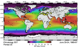
Ocean color is the branch of ocean optics that specifically studies the color of the water and information that can be gained from looking at variations in color. The color of the ocean, while mainly blue, actually varies from blue to green or even yellow, brown or red in some cases. This field of study developed alongside water remote sensing, so it is focused mainly on how color is measured by instruments.

SRON Netherlands Institute for Space Research (SRON) is the Dutch expertise institute for space research. It develops and uses innovative technology for analysis in space, focusing on astrophysical research, Earth observation, and exoplanetary research. SRON conducts research into new and more sensitive sensors for X-rays, infrared radiation, and visible light.

NOAA-18, also known as NOAA-N before launch, is an operational, polar orbiting, weather satellite series operated by the National Environmental Satellite Service (NESS) of the National Oceanic and Atmospheric Administration (NOAA). NOAA-18 also continued the series of Advanced TIROS-N (ATN) spacecraft begun with the launch of NOAA-8 (NOAA-E) in 1983 but with additional new and improved instrumentation over the NOAA A-M series and a new launch vehicle. NOAA-18 is in an afternoon equator-crossing orbit and replaced NOAA-17 as the prime afternoon spacecraft.

Landsat 8 is an American Earth observation satellite launched on 11 February 2013. It is the eighth satellite in the Landsat program; the seventh to reach orbit successfully. Originally called the Landsat Data Continuity Mission (LDCM), it is a collaboration between NASA and the United States Geological Survey (USGS). NASA Goddard Space Flight Center in Greenbelt, Maryland, provided development, mission systems engineering, and acquisition of the launch vehicle while the USGS provided for development of the ground systems and will conduct on-going mission operations. It comprises the camera of the Operational Land Imager (OLI) and the Thermal Infrared Sensor (TIRS), which can be used to study Earth surface temperature and is used to study global warming.

Sentinel-3 is an Earth observation heavy satellite series developed by the European Space Agency as part of the Copernicus Programme. It currently consists of 2 satellites: Sentinel-3A and Sentinel-3B. After initial commissioning, each satellite was handed over to EUMETSAT for the routine operations phase of the mission. Two recurrent satellites— Sentinel-3C and Sentinel-3D— will follow in approximately 2025 and 2028 respectively to ensure continuity of the Sentinel-3 mission.

ADEOS I was an Earth observation satellite launched by NASDA in 1996. The mission's Japanese name, Midori means "green". The mission ended in July 1997 after the satellite sustained structural damage to the solar panel. Its successor, ADEOS II, was launched in 2002. Like the first mission, it ended after less than a year, also following solar panel malfunctions.
GEOMS – Generic Earth Observation Metadata Standard is a metadata standard used for archiving data from groundbased networks, like the Network for the Detection of Atmospheric Composition Change (NDACC), and for using this kind of data for the validation of NASA and ESA satellite data.
IRS-1E was an Earth observation mission launched under the National Natural Resources Management System (NNRMS) programme by Indian Space Research Organisation (ISRO). Sometimes written IRS-P1. The objective of the mission was to develop Earth imagery using instruments carried on board. Due to a malfunction of the launch vehicle, the satellite deviated from its path and plunged into the Indian Ocean.

The Visible Infrared Imaging Radiometer Suite (VIIRS) is a sensor designed and manufactured by the Raytheon Company on board the polar-orbiting Suomi National Polar-orbiting Partnership, NOAA-20, and NOAA-21 weather satellites. VIIRS is one of five key instruments onboard Suomi NPP, launched on October 28, 2011. VIIRS is a whiskbroom scanner radiometer that collects imagery and radiometric measurements of the land, atmosphere, cryosphere, and oceans in the visible and infrared bands of the electromagnetic spectrum.
PRISMA is an Italian Space Agency pre-operational and technology demonstrator mission focused on the development and delivery of hyperspectral products and the qualification of the hyperspectral payload in space.

Sentinel-5 Precursor (Sentinel-5P) is an Earth observation satellite developed by ESA as part of the Copernicus Programme to close the gap in continuity of observations between Envisat and Sentinel-5.

Sentinel-4 is a European Earth observation mission developed to support the European Union Copernicus Programme for monitoring the Earth. It focuses on monitoring of trace gas concentrations and aerosols in the atmosphere to support operational services covering air-quality near-real time applications, air-quality protocol monitoring and climate protocol monitoring. The specific objective of Sentinel-4 is to support this with a high revisit time over Europe.
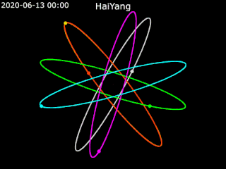
Haiyang is a series of marine remote sensing satellites developed and operated by the People's Republic of China since 2002. As of October 2022, eight satellites have been launched with ten more planned. Built by the state-owned aerospace contractor China Academy of Space Technology (CAST), Haiyang satellites carry a variety of ocean-imaging sensor payloads and are operated by the National Satellite Ocean Application Service (NSOAS), a subordinate agency of the State Oceanic Administration (SOA). Haiyang satellites are launched from Taiyuan Satellite Launch Center (TSLC) into Sun-synchronous orbit (SSO) aboard Long March-series rockets.

The Hyperspectral Imager for the Coastal Ocean (HICO) was a hyperspectral earth observation sensor that operated on the International Space Station (ISS) from 2009 to 2014. HICO collected hyperspectral satellite imagery of the earth's surface from the ISS.
